
Late Cenozoic Evolution of the Upper Mississippi River, Stream Piracy, and Reorganization of North American Mid-Continent Drainage Systems
Eric C. Carson et al.

In this article
Authors
Eric C. Carson*, J. Elmo Rawling III, John W. Attig, and Benjamin R. Bates§
Wisconsin Geological and Natural History Survey, Dept. of Environmental Sciences, University of Wisconsin–Extension, 3817 Mineral Point Road, Madison, Wisconsin 53705, USA
Abstract
River systems and associated landscapes are often viewed to exist in a dynamic equilibrium that exhibits a natural range of variability until and unless external driving forces cause a radical change such as abrupt drainage reorganization. Here, we reinterpret the late Cenozoic evolution of the upper Mississippi River and present evidence that the uppermost Mississippi River basin (upstream of the confluence of the Mississippi and Wisconsin Rivers) evolved as a late Cenozoic drainage system that carried water eastward into the Gulf of St. Lawrence and North Atlantic Ocean rather than to the Gulf of Mexico. Coring to determine the dip of a remnant strath surface in the lower Wisconsin River valley demonstrates that this valley was carved by an eastward-flowing river (opposite of the modern westward-flowing Wisconsin River). Geomorphic features, including the presence of numerous barbed tributaries along the lower Wisconsin River valley and the width and morphology of the Mississippi and Wisconsin River valleys, support this interpretation. GIS analysis of logs of water wells in east-central Wisconsin delineate the presence of a major buried valley system continuing east into the Great Lakes lowland. We herein refer to this ancestral drainage system as the “Wyalusing River.”
Quaternary glaciations played a significant role in reorganizing ancestral rivers in the Appalachians and eastern Great Lakes region to form the modern Ohio River as a tributary of the Mississippi River. We propose that Quaternary glaciations also played a significant role in capturing the Wyalusing drainage and routing it southward to the Gulf of Mexico. The total area diverted away from the Gulf of St. Lawrence and toward the Gulf of Mexico by Quaternary stream piracy represents at least ~420,000 km2 of the modern Mississippi River basin and provides nearly one quarter of the mean annual discharge of the Mississippi River. The permanent loss of that volume of freshwater runoff into the Gulf of St. Lawrence may have had a significant impact on North Atlantic thermohaline circulation and northern hemisphere climate dynamics through the Quaternary.
*Corresponding author e-mail: eric.carson@wgnhs.uwex.edu
§ Current address: Dept. of Geology, University of Cincinnati, P.O. Box 210013, Cincinnati, Ohio 45221-0013, USA.
Manuscript received 21 July 2017. Revised manuscript received 29 Sept. 2017. Manuscript accepted 30 Nov. 2017. Posted online 19 Jan. 2018.
© The Geological Society of America, 2018. CC-BY-NC.
Introduction
Over the past several decades, significant effort has been focused on constraining the flux of freshwater from the North American continent associated with the melting of the Laurentide Ice Sheet (e.g., Broecker et al., 1989; Teller, 1990; Licciardi et al., 1999; Wickert, 2016). This flux has been linked to abrupt cooling events during the last deglaciation as massive, temporary pulses of fresh meltwater off the North American continent disrupted North Atlantic thermohaline circulation (Condron and Winsor, 2012; Ivanovic et al., 2017). While much of this work has focused on abrupt climate change events during the last glaciation, the question of freshwater forcing on North Atlantic thermohaline circulation also pertains to longer timescales and processes not directly related to the demise of continental ice sheets.
For more than a century, it has been documented that the advance and retreat of Quaternary ice sheets in North America has profoundly altered fluvial drainage patterns (Fig. 1A). The southwesterly path of the Missouri River is the direct result of rerouting the river roughly parallel to the Marine Oxygen Isotope Stage 2 (MIS 2) ice margin (Todd, 1914; Flint, 1949; Dyke et al., 2002) and likely bears little resemblance to earlier Cenozoic drainage in the region (Sears, 2013). The modern Ohio River was formed by the blockage of several northward-flowing rivers by early to middle Quaternary glaciers that were rerouted to become a tributary of the Mississippi River (e.g., Wright, 1890; Chamberlin and Leverett, 1894; Tight, 1903). While some researchers have suggested alternate pre-Quaternary configurations of the upper Mississippi River (Hobbs, 1997) or changes in the size of the draining basin through the Quaternary (Knox, 2007; Galloway et al., 2011; Cox et al., 2014; Cupples and Van Arsdale, 2014), it has been axiomatic that the general course and planform of the upper Mississippi River evolved through the late Cenozoic as it appears today (e.g., Baker et al., 1998). Although some of the documented alterations to drainage systems have amounted to simply repositioning a reach of a river channel, other events have amounted to large-scale stream piracy that has redirected runoff to an entirely new master stream. This is particularly evident in the Ohio River basin, where rivers that flowed north to the Gulf of St. Lawrence prior to Quaternary glaciations were rerouted toward the Gulf of Mexico to become tributaries to the Mississippi River (Coffey, 1958). The record of late Cenozoic stream piracy is particularly significant in the humid eastern portions of the North American mid-continent, where a disproportionately large amount of its freshwater runoff into the oceans is derived.
Figure 1
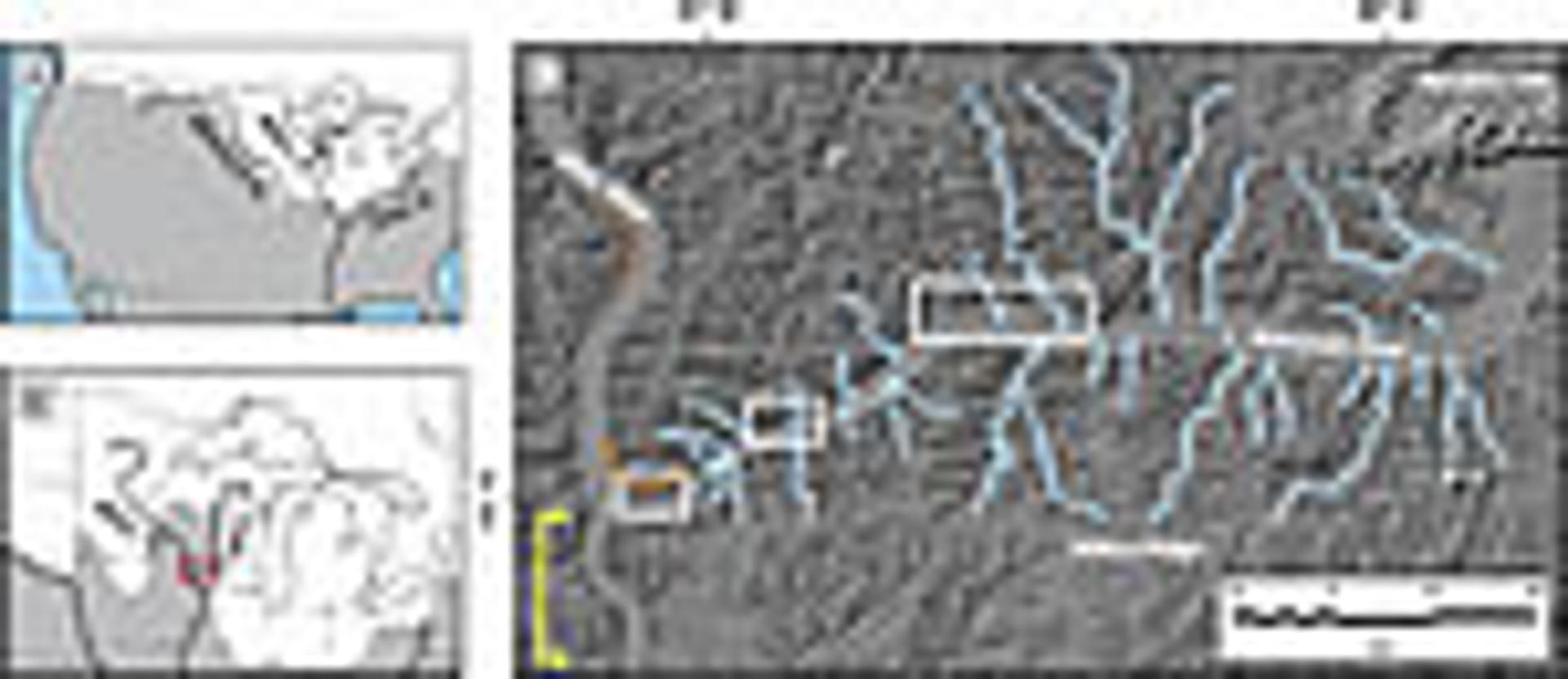
Location maps of study area. (A) Major tributaries of the Mississippi River system in relation to the maximum extent of all Quaternary glaciations, shown in white. The unglaciated Driftless Area (DA) shown in upper Midwest. (B) Location of the upper Mississippi River and Wisconsin River in relation to the maximum extent of MIS 2 glaciation, shown in white. Area of Figure 1C shown by red box. (C) LiDAR-derived hillshade image of the lower Wisconsin River valley and confluence with the Mississippi River. The three remnant segments of the Bridgeport strath are located within the white boxes, identifying areas of detailed maps in Figure 2. The white circle immediately south of the confluence of the Wisconsin and Mississippi Rivers indicates the location of the town of Wyalusing, Wisconsin, USA. Geomorphological features of the lower Wisconsin River valley that indicate drainage reorganization has occurred: barbed tributaries of the lower Wisconsin River (pale blue arrows); the curved inner valley wall at the confluence of the Wisconsin and Mississippi Rivers (solid orange line) more similar to the inside of a bend on a single river (example identified by dashed orange lines); narrow reach of the Mississippi River immediately downstream its confluence with the Wisconsin River (yellow bracketing arrows).
It is within the context of stream piracy and routing of freshwater off the North American mid-continent that we investigated the lower Wisconsin River valley in the Driftless Area of southwestern Wisconsin (Figs. 1A and 1B). As an isolated area of unglaciated terrain north of the overall maximum extent of Quaternary glaciations in North America, the Driftless Area provides a much longer temporal window to landscape and drainage basin evolution than in the surrounding glaciated regions. This allows the opportunity to reevaluate the late Cenozoic evolution of the upper Mississippi River basin, and to assess the impact of diversion of freshwater runoff from the North American mid-continent away from the North Atlantic Ocean and toward the Gulf of Mexico.
Study Area and Background
The upper Mississippi watershed is a major sub-basin of the greater Mississippi River system that has been significantly impacted by Quaternary glaciations. The upper Mississippi and Wisconsin Rivers and their major tributaries (Fig. 1) all cross the MIS 2 glacial margin and exhibit the effects of multiple Quaternary glaciations on their geomorphology, planform, and course (Warren, 1884; MacClintock, 1922). Buried bedrock valleys, modern streams under-fit to the bedrock channels in which they flow, and river courses aligned to former ice margin positions are common features. Furthermore, late Quaternary glaciations drove sequences of aggradation and incision, producing multiple cut-and-fill terraces along the upper Mississippi and lower Wisconsin Rivers and their tributaries; several outwash terraces are graded to a higher elevation than the modern floodplain surface (Flock, 1983; Knox, 1996). In the North American mid-continent, however, the lower Wisconsin River is atypical among major rivers for containing prominent remnants of a strath (bedrock) terrace. This surface, known as the Bridgeport terrace, is found at a higher elevation than adjacent depositional terraces along the Wisconsin River. Three isolated remnants of the strath occur within 60 km of the confluence of the Wisconsin and Mississippi Rivers (Figs. 1C and 2).
The lower Wisconsin River flows west from the Baraboo Hills in south-central Wisconsin through the Driftless Area to its confluence with the Mississippi River. This region of southwestern Wisconsin was apparently never glaciated during the Quaternary (Chamberlain, 1883; Alden, 1918), an observation that has been recognized since the 1820s (Martin, 1932). It is bounded on the east by MIS 2 glacial deposits, and on the north, west, and south by older glacial sediment. Regionally, the Paleozoic sedimentary bedrock is heavily dissected by fluvial incision (Trotta and Cotter, 1973) that is expressed in the hilly surface morphology because of the lack of Quaternary glacial deposits in the Driftless Area. While a traditional explanation for the particularly deep incision of the upper Mississippi and lower Wisconsin Rivers and their tributaries is simply surface expression of long-term process, a compelling argument will be made here that the lack of glacial cover in the Driftless Area affords a window to view late Cenozoic drainage integration of the upper Mississippi River basin.
Within the lower Wisconsin River valley, Knox and Attig (1988) identified a moraine and glacial outwash consistent with a glacial advance from the west to a few kilometers east of the confluence of the modern Wisconsin and Mississippi Rivers (Fig. 2A). The outwash, preserved on the Bridgeport strath, contains eastward-dipping foreset bedding, indicating that water flow at the time of deposition was in the opposite direction as flow of the modern Wisconsin River. Reversed polarity to the remnant magnetism of this sediment indicates it was deposited prior to ~780,000 years ago. They hypothesized that this glaciation blocked the mouth of the Wisconsin River and caused a temporary reversal of flow to the east.
Figure 2
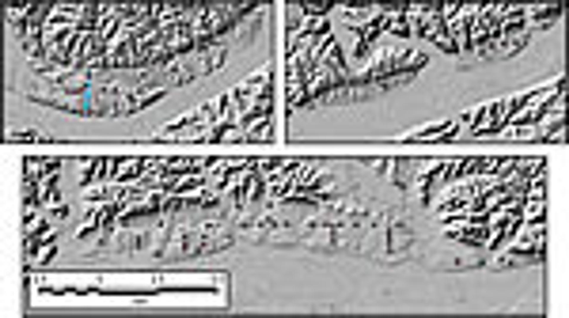
Detailed LiDAR-derived hillshade maps of the three remnant segments of the Bridgeport strath as identified in Figure 1, showing (A) the westernmost segment; (B) the central segment; and (C) the easternmost segment. Red squares identify locations of Geoprobe coring to determine bedrock surface elevations. Blue diamonds identify locations where Paleozoic bedrock crops out, verifying that the surface is a strath terrace. Blue dashed line in (A) identifies the location of the Bridgeport moraine, which represents the farthest west extent of a pre-Illinoian glaciation that advanced out of Minnesota and Iowa (Knox and Attig, 1988). All images are shown at the same scale.
An alternate hypothesis to the presumption that the lower Wisconsin River valley was incised through the late Cenozoic by a westward-flowing river and experienced a temporary reversal of flow at the time of the “Bridgeport” glaciation is that incision of the lower Wisconsin River valley to the level of the Bridgeport strath was accomplished through the late Cenozoic by an eastward-flowing river. A subsequent stream piracy event caused a permanent reversal to the modern westward flow. The test of this hypothesis is to identify the direction of dip of the bedrock surface of the Bridgeport strath, which necessarily dips in the direction of water flow at the time it was the bedrock floor of the valley.
Methods and Results
Testing this alternate hypothesis required coring through the unconsolidated sediment on the terrace to establish bedrock elevations at numerous points along the length of the terrace. This was accomplished using a combination of high-resolution LiDAR-derived digital elevation models to precisely identify ground-surface elevation to within ~5 cm and Geoprobe direct-push coring to precisely identify depth to bedrock to within ~2.5 cm. The strath surface is comprised of glauconitic units of the Cambrian Tunnel City Group, which facilitated unambiguous recognition of the transition between Quaternary sediment and the strath. Cores were collected from 62 sites on the strath surface on an ~60-km transect (Fig. 2; GSA Data Repository Table 11). The highest bedrock elevation points were connected, based on the assumption that they represent a good proxy for the original, un-eroded bedrock surface (see Data Repository Fig. 1 [see footnote 1]).
--------
1 GSA Data Repository Item 2017404, supplementary core and well log data and methods used to support interpretations, is online at www.geosociety.org/datarepository/2017/.
As expected, individual coring sites reveal considerable variability below the (upper) trend line of the original strath surface owing to localized erosion following abandonment. However, the trend of the strath dips to the east, in the opposite direction of flow of the modern Wisconsin River, with an estimated gradient of 0.15 m/km (Fig. 3A). The gradient of the strath surface estimated from coring is consistent over a broad scale with many other mid-continent streams, and close to the gradients of the modern lower Wisconsin River floodplain and associated MIS 2 outwash terraces. Within the context of the westward-dipping late Quaternary surfaces in the lower Wisconsin River valley, the eastward dip of the Bridgeport strath stands in stark contrast (Fig. 3B). The inescapable conclusion to be drawn from the orientation of the strath is that the lower Wisconsin River valley was carved to the level of the Bridgeport strath by a river flowing to the east.
Figure 3
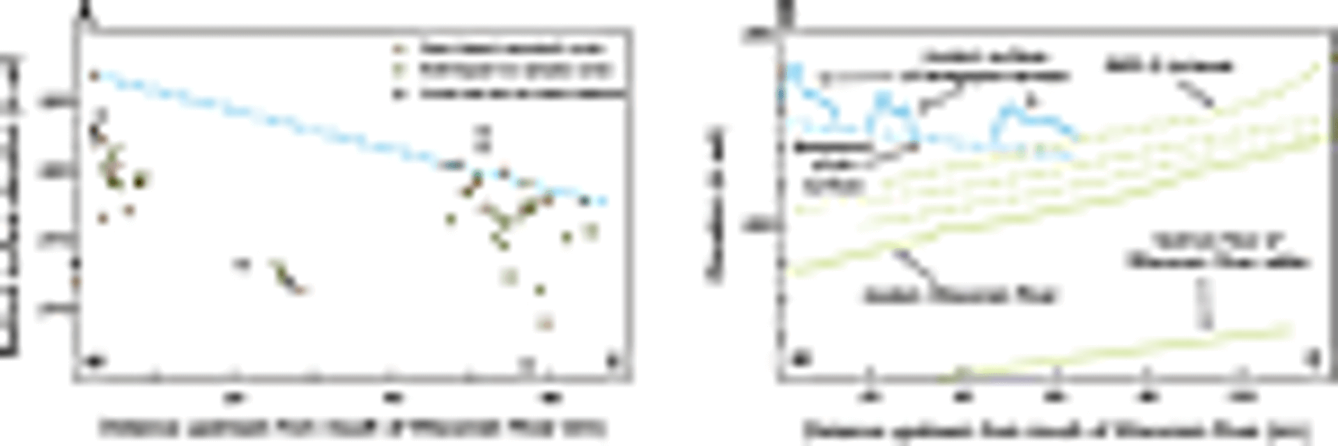
Results of Geoprobe coring to determine dip of strath surface. (A) Elevation of strath surface at each coring site as a function of distance upstream from the mouth of the Wisconsin River. Trendline (blue dashed line) represents original strath surface, dipping to the east with an estimated slope of 0.15 m/km; asl—above sea level. (B) Bridgeport strath surface as resolved from Geoprobe coring (eastward-dipping blue dashed line) in relation to other major (westward-dipping) surfaces in the lower Wisconsin River valley; modified from Knox and Attig (1988).
Geomorphology of the Lower Wisconsin River Valley
Transformative events to the landscape should—and often do—leave indications of previous conditions, and the geomorphology of the lower Wisconsin River valley contains several indications of having been formed by an eastward-flowing river (Fig. 4). They are as follows:
Figure 4
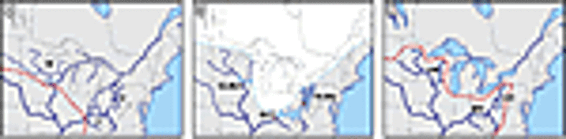
Proposed time series for the common processes that drove stream piracy and reorganization of pre-Quaternary drainage patterns in the North American mid-continent to create the modern Ohio (MO) and upper Mississippi (UM) Rivers. (A) Proposed configuration of the ancestral Wyalusing (W), Teays (T), and Pittsburgh (P) Rivers as they evolved prior to Quaternary glaciations. Red dashed line represents the approximate location of the continental drainage divide. (B) Damming of the lower St. Lawrence drainage by early to middle Quaternary glaciation(s) blocked the ancestral Wyalusing River to create the informally named glacial Lake Muscoda (GLMu); the ancestral Teays River to create glacial Lake Tight (GLT); and the ancestral Pittsburgh River to create glacial Lake Monongahela (GLMo). Spill-over of the lakes at the lowest drainage divides (red diamonds) initiated reorganization of river systems. (C) Modern drainage configuration, with continental drainage divide (red dashed line) moved northward as drainage capture diverted river systems away from the Gulf of St. Lawrence and toward the Gulf of Mexico. UO—upper Ohio River.
- The lower Wisconsin River valley, between the modern confluence with the Mississippi River and the MIS 2 glacial margin, has a large number of barbed tributaries—valleys that join the lower Wisconsin River valley angling to the east, as would be expected if they formed over time as tributaries to an eastward-flowing river (blue arrows in Fig. 1C). Lacking an overriding structural control, the presence of barbed tributary valleys has long been held as primary evidence of reversal of flow on the mainstem stream (e.g., Chamberlin and Leverett, 1894, p. 265).
- The curve of the valley wall at the inside of the confluence of the modern Mississippi and Wisconsin Rivers (i.e., to the immediate northeast; solid orange in Fig. 1C) is inconsistent with having been incised as the confluence of two rivers. Rather than coming to a point as would be expected at the confluence of streams in a dendritic system, the valley wall is a smooth curved radius. It is consistent with being at the inside of a tight bend of a single river; numerous similar forms can be found along the insides of curves along the upper Mississippi and lower Wisconsin Rivers.
- The lower Wisconsin River valley narrows incongruously from east to west. Lacking overriding bedrock geologic control, river valleys broaden in the downstream direction. The narrowing in the downstream direction exhibited in the lower Wisconsin River valley lends additional credence to the argument for a valley that was incised by an eastward-flowing river and subsequently reversed.
Geomorphology of the Upper Mississippi River
In addition to the lower Wisconsin River displaying geomorphic features that reflect a major reorganization, the Mississippi River also contains a hallmark feature of stream piracy. The reach of the Mississippi River valley immediately south of its confluence with the Wisconsin River is distinctly narrow with short, steep tributaries (yellow bracket in Fig. 1C). The dissimilarity of these tributaries to other valleys throughout the region is so striking, in fact, that the tributaries to the Mississippi River immediately north and south of the confluence with the Wisconsin River are locally referred to by the etymologically distinct term “coulee.” While these characteristics could be attributed to incision through the bedrock escarpment formed by resistant Ordovician dolostone in the area, they are consistent with a stream that has experienced recent and pronounced down-cutting driven by base-level adjustment following stream piracy. Within the context of recognizing a major reversal on the nearby lower Wisconsin River valley, it should not be surprising that the Mississippi River valley contains geomorphic features that reflect such a significant reorganization of drainage patterns.
Discussion
The Ancestral Wyalusing River and the Continental Drainage Divide
Recognition of an eastward-flowing river occupying the modern lower Wisconsin River valley necessitates consideration of the larger drainage pattern required to achieve this configuration. We propose that a river that we herein refer to as the “Wyalusing River” (named for the town of Wyalusing, Wisconsin, USA, immediately south of the confluence of the Wisconsin and Mississippi Rivers; Fig. 1C) developed through the late Cenozoic flowing eastward to incise the valley now occupied by the lower Wisconsin River. The high, east-west–trending ridge to the south of the lower Wisconsin River valley, known locally as Military Ridge (Fig. 1C), is formed by the resistant dolostone of the Ordovician Galena and Platteville Formations; the topographic ridge formed by this bedrock structure represents a logical location for a major drainage divide separating southward flow to the Gulf of Mexico from northeastward flow toward the Gulf of St. Lawrence. In this configuration, the numerous barbed tributaries along the modern lower Wisconsin River are explained; the curve of the valley wall at the modern confluence of the Mississippi and Wisconsin Rivers is simply the inside of a bend in the Wyalusing River; and the width of the valley along this reach broadens in the downstream direction as would typically be expected.
Downstream Continuation of the Wyalusing River
Late Quaternary glacial deposits obscure direct evidence for the course of this river east of the Baraboo Hills (Fig. 1C). However, depth-to-bedrock maps (Trotta and Cotter, 1973) and previous studies (Stewart, 1976) show a deep, buried bedrock valley that trends southwest-to-northeast in the east-central portion of the state. To evaluate this buried valley as a potential downstream continuation of the Wyalusing River system, Bates and Carson (2013) assessed 115,176 logs of water wells in east-central Wisconsin. As needed, logs were geo-located in ArcGIS to accurately identify ground surface elevation and sorted to remove logs that lacked relevant depth-to-bedrock information. After this processing, a total of 60,186 logs were used to generate a buried bedrock elevation map for east-central Wisconsin extending from the easternmost extent of the Bridgeport strath in the lower Wisconsin River valley to the shores of Green Bay. The resulting bedrock topography map identifies the presence of a buried bedrock valley trending to the more than 300 km northeast toward the Lake Michigan/Huron lowlands at the appropriate elevation and grade to be the continuation of the Wyalusing River (GSA Data Repository Fig. 2 [see footnote 1]). Having been traced into the Lake Michigan basin, we conclude that the Wyalusing River was the westernmost tributary of a major river system that drained the North American mid-continent through the St. Lawrence lowland to the Atlantic Ocean.
As such, this represents a significant drainage area that evolved through the late Cenozoic as part of the St. Lawrence drainage basin that has been pirated and converted to the headwaters of the Mississippi drainage basin. Reversal of the Wyalusing River and, as a result, redirection of the mainstem Mississippi River upstream of the modern confluence with the Wisconsin River, added 205,000 km2 to the modern Mississippi River basin. This is 6.9% of its total watershed area. This event likely occurred sometime during the early to middle Quaternary as constrained by the reversed paleomagnetism of fine-grained sediments within sand and gravel that were deposited while the river still drained to the Gulf of St. Lawrence (i.e., the deposits identified by Knox and Attig [1988] that are associated with eastward-dipping foreset beds). As interpreted by the data presented here, the conversion of the basin from the St. Lawrence to the Mississippi drainage involves shifting the continental drainage divide northward across Wisconsin and Minnesota. As an independent verification, our field-based interpretation of this drainage reorganization is consistent with the evolution of North American drainage systems through the Cenozoic as inferred by the volume and geometry of sediment packages deposited in the Gulf of Mexico (Galloway et al., 2011).
Reorganization of North American Mid-Continent Drainages
Having traced the ancestral Wyalusing River into the Lake Michigan basin, and thus into the St. Lawrence drainage, it is possible to consider the larger drainage patterns that are implicated by such a configuration of this river. The evolution of the ancestral Wyalusing River from headwaters of the St. Lawrence drainage system to its modern configuration as headwaters of the Mississippi drainage system is likely intimately associated with Quaternary glaciations. While this is a new observation in the upper Mississippi basin, it is not unique in the greater Mississippi basin. It has long been recognized that the ancestral Pittsburgh and Teays Rivers were rerouted to become the upper and middle Ohio River when Quaternary ice centered in the Hudson Bay region advanced far enough south to block the lower portions of the St. Lawrence valley (e.g., Chamberlin and Leverett, 1894; Tight, 1903). This caused large proglacial lakes to form: glacial Lake Monongahela in the ancestral Pittsburgh River valley (White, 1896; Leverett, 1934) and glacial Lake Tight in the ancestral Teays River valley (Janssen, 1953; Goldthwait, 1983). While there is a lack of consensus as to whether the ancestral Teays system drained to the St. Lawrence or into the now-buried Mahomet River system in Illinois (flowing toward the Gulf of Mexico) prior to Quaternary glaciations, it is certainly viable that the Teays River developed as a tributary of the St. Lawrence drainage and was pirated multiple times (e.g., Coffey, 1958; Gray, 1991). Spill-over of those lakes at the lowest drainage divide initiated stream piracy events that reorganized those river systems to become the modern Ohio River that drains to the Gulf of Mexico (Fig. 4). An isotopic signal for this reversal may be preserved in Gulf of Mexico sediments (e.g., Joyce et al., 1993; Shakun et al., 2016), although the clarity of such a signal would be a function of whether all drainages in the Midwest and Appalachians were rerouted in a short period of time or over multiple glaciations.
As outlined here, the ancestral Wyalusing River was also a tributary to the St. Lawrence River system prior to Quaternary glaciations. As such, a common mechanism for the reorganization of the Ohio and upper Mississippi Rivers during the Quaternary is logical and appealing. The early to middle Quaternary glaciations that blocked the lower St. Lawrence drainage and caused the reorganization of the modern Ohio River necessarily would have also blocked the ancestral Wyalusing River in the Midwest. This provides a single causative agent for reorganization of drainage systems across the eastern and Midwestern United States. Farther to the west, evidence exists that the area currently drained by the Missouri River was modified such that the modern Missouri River closely follows the MIS 2 margin, though it may previously have contributed additional drainage area and runoff to the Gulf of St. Lawrence–directed system.
Hemispheric Implications
The area of the combined ancestral Pittsburgh, Teays, and Wyalusing River basins is significant, representing at least ~420,000 km2 of the modern Mississippi River basin that has been pirated from the pre-Quaternary St. Lawrence River basin. Because these areas are located in the relatively humid portion of the larger Mississippi basin, they represent a disproportionately large amount of the Mississippi River’s discharge. Analysis of modern gage records indicates that these pirated basins represent ~14% of the area of the Mississippi River basin yet contribute nearly one quarter of the mean annual discharge of the Mississippi River (Carson et al., 2014), roughly equivalent to 150 km3/year of water (a permanent diversion of nearly 5,000 m3/s, based on modern hydrology). While this amount of freshwater is small relative to late Quaternary outburst floods that temporarily disrupted North Atlantic thermohaline circulation (e.g., Teller, 1990; Licciardi et al., 1999; Clark et al., 2001), piracy of these basins in the midcontinent and flux of that water away from the Gulf of St. Lawrence and toward the Gulf of Mexico represents a permanent step-function decrease in freshwater delivery to the North Atlantic from a non-climatic source. These estimations of drainage area shift and discharge flux are based on modern morphologies and flow regimes; the redirection of glacial meltwater toward the Gulf of Mexico following reorganization would only serve to further increase the significance of drainage reorganization on freshwater delivery to the Gulf of Mexico (Wickert et al., 2013; Wickert, 2016).
It has long been understood that the delivery of freshwater, and particularly fresh meltwater during glaciations, exerts a significant control on North Atlantic thermohaline circulation. Multiple studies (Broecker et al., 1989; Condron and Winsor, 2012; Ivanovic et al., 2017) have shown that a large pulse of meltwater was the mechanism that initiated the Younger Dryas by reducing Atlantic Meridional Overturning Circulation (AMOC), which led to cooler air and surface temperatures and increased ice cover. However, previous studies have focused on the effects of a large, discrete meltwater pulse derived from the demise of a North American ice sheet. The data and interpretations presented herein raise the question of the ability of a much smaller, though permanent, flux in continental runoff caused by drainage reorganization to impact North Atlantic thermohaline circulation.
For example, the middle Pleistocene is noted for a step-function shift in the periodicity of glacial maxima from a predominantly 41-k.y. cycle to a 100-k.y. cycle (Shackleton and Opdyke, 1976). This Middle Pleistocene Transition (MPT) took place between 1250 and 700 ka. Lacking a stochastic cause for this shift in glacial periodicity derived directly from orbital forcing, a deterministic mechanism is required. Numerous mechanisms have been proposed to explain the occurrence of the MPT, including physical processes associated with calving and meltwater discharge feedback (DeBlonde and Peltier, 1991); long-term deepwater cooling (Tziperman and Gildor, 2003); or the progressive erosion of regolith from the North American continent during successive early Quaternary glaciations that eventually exposed unweathered bedrock across the craton (Clark and Pollard, 1998; Clark et al., 2006). The budget of freshwater delivery to the North Atlantic Ocean is one of the major determinants of the strength of North Atlantic thermohaline circulation (Clark et al., 2002); the strength and structure of North Atlantic thermohaline circulation, in turn, plays a critical role in driving global heat transfer and climatic fluctuations. For example, coupled thermohaline circulation and energy balance climate models (e.g., Sakai and Peltier, 1997) demonstrate climate sensitivity to freshwater runoff from ice sheets. While this and similar studies explicitly investigate glacial versus non-glacial conditions during the late Pleistocene, a future avenue of investigation would be to assess the effects of a permanent step-function flux of freshwater away from the North Atlantic and toward the Gulf of Mexico. This may provide insight into the effect that reorganization of continental drainage systems may have imparted on the thermohaline circulation in the North Atlantic Ocean, thus providing an alternate explanation, or contributing factor, for the change in periodicity of glaciations associated with the MPT.
Conclusions
Coring to resolve the elevation of the bedrock surface of the Bridgeport strath along the lower Wisconsin River valley indicates that the strath surface dips to the east at an estimated slope of 0.15 m/km, as opposed to the westward dip of the bedrock floor of the valley, the modern floodplain surface, and all late Quaternary depositional outwash terraces. The direct conclusion drawn from the coring data is that incision of the lower Wisconsin River valley was achieved by an eastward-flowing river during the late Cenozoic, rather than by the westward-flowing modern Wisconsin River. Numerous geomorphic features along the lower Wisconsin River valley support the interpretation of a reversal of flow and reorganization of drainage patterns at some point in the past. Investigation of a buried bedrock valley in east-central Wisconsin confirms that this feature represents the downstream continuation of the river referred to herein as the Wyalusing River. Having been traced into the Lake Michigan basin, we conclude that this river evolved as part of the headwaters of the St. Lawrence drainage basin and drained into the Gulf of St. Lawrence to the northeast rather than the Gulf of Mexico to the south.
The data indicate that the entire upper Mississippi/Wisconsin River system upstream of the modern confluence of the Mississippi and Wisconsin River originally developed as an eastward-flowing system. As has been documented for several reaches of the modern Ohio River, we propose that early and/or middle Quaternary glaciations blocked the downstream portions of the St. Lawrence drainage basin, creating an ice-dammed lake in the Wyalusing River valley. Stream piracy at the location that is now the confluence of the Mississippi and Wisconsin Rivers redirected an area of ~205,000 km2 to the south as part of the greater Mississippi River basin. The stream piracy event caused a permanent reversal of flow along the lower Wisconsin River valley, and adjustment to the new base level drove subsequent incision along the lower Wisconsin and upper Mississippi Rivers and their tributaries, which left only the few remnant segments of the Bridgeport strath that exist today. These data and interpretations are consistent with independent studies of Cenozoic drainage evolution in the North American mid-continent as determined by alluvial sediment in the Gulf of Mexico (e.g., Galloway et al., 2011).
Acknowledgments
Initial conversations guiding the direction of this research are indebted to James C. Knox (deceased).The manuscript was significantly improved thanks to the critical comments provided by three anonymous reviewers, as well as the comments provided by C. Jennings and H. Loope on an earlier draft. GIS support was provided by S. Mauel, P. Schoephoester, and E. Ceperley. As a sounding board in the past and future, ECC would like to thank MKR. This work was partially funded by grants from STATEMAP (G12AC20121 and G13AC00138) and the Great Lakes Geologic Mapping Coalition (G12AC20388 and G13AC00296), and by the Wisconsin Geological and Natural History Survey.
References
- Alden, W.C., 1918, Quaternary geology of south-eastern Wisconsin: U.S. Geological Survey Professional Paper 106, 251 p.
- Baker, R.W., Knox, J.C., Lively, R.S., and Olsen, B.R., 1998, Evidence for early entrenchment of the upper Mississippi River valley, in Patterson, C.J., and Wright, H.E., Jr., eds., Contributions to Quaternary Studies in Minnesota: Minnesota Geological Survey Report of Investigations 49, p. 113–120.
- Bates, B.R., and Carson, E.C., 2013, GIS-based delineation of a buried bedrock valley in east-central Wisconsin: Geological Society of AmericaAbstracts with Programs, v. 46, no. 6, p. 45.
- Broecker, W.S., Kennett, J.P., Flower, B.P., Teller, J.T., Trumbore, S., Bonani, G., and Wolfli, W., 1989, Routing of meltwater from the Laurentide ice sheet during the Younger Dryas cold episode: Nature, v. 341, p. 318–321, https://doi.org/10
- .1038/341318a0.
- Carson, E.C., Rawling, J.E., III, Attig, J.W., and Bates, B.R., 2014, Quaternary reorganization of the Mississippi and St. Lawrence drainage basins: Geological Society of AmericaAbstracts with Programs, v. 46, no. 6, p. 378.
- Chamberlin, T.C., 1883, General Geology of Wisconsin: Geology of Wisconsin, v. 1, 300 p.
- Chamberlin, T.C., and Leverett, F., 1894, Further studies of the drainage features of the upper Ohio basin: American Journal of Science, v. 47, p. 247–283, https://doi.org/10.2475/ajs.s3-47.280.247.
- Clark, P.U., and Pollard, D., 1998, Origin of the middle Pleistocene transition by ice sheet erosion of regolith: Paleoceanography, v. 13, p. 1–9, https://doi.org/10.1029/97PA02660.
- Clark, P.U., Marshall, S.J., Clarke, G.K.C., Hostetler, S.W., Licciardi, J.M., and Teller, J.T., 2001, Freshwater forcing of abrupt climate change during the last deglaciation: Science, v. 293, p. 283–287, https://doi.org/10.1126/science.1062517.
- Clark, P.U., Pisias, N.G., Stocker, T.F., and Weaver, A.J., 2002, The role of the thermohaline circulation in abrupt climate change: Nature, v. 415, p. 863–869, https://doi.org/10.1038/415863a.
- Clark, P.U., Archer, D., Pollard, D., Blum, J.D., Rial, A.D., Brovkin, V., Mix, A.C., Pisias, N.G., and Roy, M., 2006, The middle Pleistocene transition: Characteristics, mechanisms, and implications for long-term changes in atmospheric pCO2: Quaternary Science Reviews, v. 25, p. 3150–3184, https://doi.org/10.1016/j.quascirev.2006.07.008.
- Coffey, G.N., 1958, Major glacial drainage changes in Ohio: The Ohio Journal of Science, v. 58, p. 43–49.
- Condron, A., and Winsor, P., 2012, Meltwater routing and the Younger Dryas: Proceedings of the National Academy of Sciences of the United States of America, v. 109, p. 19,928–19,933, https://doi.org/10.1073/pnas.1207381109.
- Cox, R.T., Lumsden, D.N., and Van Arsdale, R.B., 2014, Possible relict meanders of the Pliocene Mississippi River and their implications: The Journal of Geology, v. 122, p. 609–622, https://doi.org/10.1086/676974.
- Cupples, W., and Van Arsdale, R., 2014, The preglacial “Pliocene” Mississippi River: The Journal of Geology, v. 122, p. 1–15, https://doi.org/10.1086/674073.
- DeBlonde, G., and Peltier, W.R., 1991, A one-dimensional model of continental ice volume fluctuations through the Pleistocene: Implications for the origin of the mid-Pleistocene climate transition: Journal of Climatology, v. 4, p. 318–344, https://doi.org/10.1175/1520-0442(1991)004<0318:AODMOC>2.0.CO;2.
- Dyke, A.S., Andrews, J.T., Clark, P.U., England, J.H., Miller, G.H., Shaw, J., and Veillette, J.J., 2002, The Laurentide and Innuitian ice sheets during the Last Glacial Maximum: Quaternary Science Reviews, v. 21, p. 9–31, https://doi.org/10.1016/S0277-3791(01)00095-6.
- Flint, R.F., 1949, Pleistocene drainage diversions in South Dakota: Geografiska Annaler, v. 31, p. 56–74.
- Flock, M.A., 1983, The Late Wisconsinan Savanna Terrace in tributaries to the upper Mississippi River: Quaternary Research, v. 20, p. 165–176.
- Galloway, W.E., Whiteaker, T.L., and Ganey-Curry, P., 2011, History of Cenozoic North American drainage basin evolution, sediment yield, and accumulation in the Gulf of Mexico basin: Geosphere, v. 7, p. 938–973, https://doi.org/10.1130/GES00647.1.
- Goldthwait, R.P., 1983, Drainage revolution fostered by Lake Tight: The Ohio Journal of Science, v. 83, p. 27–28.
- Gray, H.H., 1991, Origin and history of the Teays drainage system: A view from midstream, in Melhorn, W.N., and Kempton, J.P., eds., Geology and Hydrogeology of the Teays-Mahomet Bedrock Valley System: Geological Society of America Special Paper 258, p. 42–50.
- Hobbs, H.C., 1997, Did the preglacial Mississippi River in Minnesota flow northward to the Arctic Ocean?: Geological Society of America Abstracts with Programs, v. 29, no. 6, p. 20.
- Ivanovic, R.F., Gregoire, L.J., Wickert, A.D., Valdes, P.J., and Burke, A., 2017, Collapse of the North American ice saddle 14,500 years ago caused widespread cooling and reduced ocean overturning circulation: Geophysical Research Letters, v. 44, p. 383–392, https://doi.org/10.1002/2016GL071849.
- Janssen, R.E., 1953, Varved clays in the Teays Valley: West Virginia Academy of Science Proceedings, v. 25, p. 53–54.
- Joyce, J.E., Tjaisma, L.R.C., and Prutzman, J.M., 1993, North American glacial meltwater history for the past 2.3 m.y.: Oxygen isotope evidence from the Gulf of Mexico: Geology, v. 21, p. 483–486, https://doi.org/10.1130/0091-7613(1993)021<0483:NAGMHF>2.3.CO;2.
- Knox, J.C., 1996, Late Quaternary upper Mississippi River alluvial episodes and their significance to the lower Mississippi River: Engineering Geology, v. 45, p. 263–285.
- Knox, J.C., 2007, The Mississippi River System, in Gupta, A., ed., Large Rivers: Geomorphology and Management: New York, John Wiley & Sons, p. 145–182, https://doi.org/10.1002/9780470723722.ch9.
- Knox, J.C., and Attig, J.W., 1988, Geology of the pre-Illinoian sediment in the Bridgeport Terrace, lower Wisconsin River valley, Wisconsin: The Journal of Geology, v. 96, p. 505–514, https://doi.org/10.1086/629244.
- Leverett, F., 1934, Glacial deposits outside the Wisconsin terminal moraine in Pennsylvania: Pennsylvania Geological Survey, 4th series, General Geology Report 7, 123 p.
- Licciardi, J.M., Teller, J.T., and Clark, P.U., 1999, Freshwater routing by the Laurentide Ice Sheet during the last deglaciation, in Clark, P.U., Webb, R.S., and Keigwin, L.D., eds., Mechanisms of Global Climate Change at Millennial Time Scales: American Geophysical Union Monograph 112, p. 177–202, https://doi.org/10.1029/GM112p0177.
- MacClintock, P., 1922, The Pleistocene history of the lower Wisconsin River: The Journal of Geology, v. 29, p. 615–626.
- Martin, L.M., 1932, The Physical Geography of Wisconsin: Madison, University of Wisconsin Press, Wisconsin Geological and Natural History Survey Bulletin 36, 608 p.
- Sakai, K., and Peltier, W.R., 1997, Dansgaard-Oeschger oscillations in a coupled atmosphere-ocean climate model: Journal of Climate, v. 10, p. 949–970, https://doi.org/10.1175/1520-0442(1997)010<0949:DOOIAC>2.0.CO;2.
- Sears, J.W., 2013, Late Oligocene–early Miocene Grand Canyon: A Canadian connection?: GSA Today, v. 23, p. 4–10, https://doi.org/10.1130/GSATG178A.1.
- Shackleton, N.J., and Opdyke, N.D., 1976, Oxygen-isotope and paleomagnetic stratigraphy of Pacific core V28–239: Late Pliocene to latest Pleistocene, in Cune, R.M., and Hays, J.D., eds., Investigation of Late Quaternary Paleoceanography and Paleoclimatology: Geological Society of America Memoir 145, p. 449–464, https://doi.org/10.1130/MEM145-p449.
- Shakun, J.D., Raymo, M.E., and Lea, D.W., 2016, An early Pleistocene Mg/Ca-d18O record from the Gulf of Mexico: Evaluating ice sheet size and pacing in the 41-kyr world: Paleoceanography, v. 31, p. 1011–1027, https://doi.org/10.1002/2016PA002956.
- Stewart, M.T., 1976, An integrated geologic, hydrology, and geophysical investigation of drift aquifers, western Outagamie County, Wisconsin [Ph.D. dissertation]: University of Wisconsin–Madison, 165 p.
- Teller, J.T., 1990, Volume and routing of late-glacial runoff from the southern Laurentide Ice Sheet: Quaternary Research, v. 34, p. 12–23, https://doi.org/10.1016/0033-5894(90)90069-W.
- Tight, W.G., 1903, Drainage modifications in southeastern Ohio and adjacent parts of West Virginia and Kentucky: U.S. Geological Survey Professional Paper 12, 111 p.
- Todd, J.E., 1914, The Pleistocene history of the Missouri River: Science, v. 39, p. 263–274, https://doi.org/10.1126/science.39.999.263.
- Trotta, L.C., and Cotter, R.D., 1973, Depth to bedrock in Wisconsin: Wisconsin Geological and Natural History Survey 1:1,000,000-scale map, 1 sheet.
- Tziperman, E., and Gildor, H., 2003, On the mid-Pleistocene transition to 100-kyr glacial cycles and the asymmetry between glaciation and deglaciation time: Paleoceanography, v. 18, p. 1-1–1-8, https://doi.org/10.1029/2001pa000627.
- Warren, U., 1884, The Minnesota Valley in the Ice Age: American Journal of Science, v. 27, p. 157–162.
- White, I.C., 1896, Origin of the high terrace deposits of the Monongahela River: American Geologist, v. 18, p. 368–379.
- Wickert, A.D., 2016, Reconstruction of North American drainage basins and river discharge since the Last Glacial Maximum: Earth Surface Dynamics, v. 4, p. 831–869, https://doi.org/10.5194/esurf-4-831-2016.
- Wickert, A.D., Mitrovica, J.X., Williams, C., and Anderson, R.S., 2013, Gradual demise of a thin southern Laurentide ice sheet recorded by Mississippi drainage: Nature, v. 502, p. 668–671, https://doi.org/10.1038/nature12609.
- Wright, G.F., 1890, The glacial boundary in western Pennsylvania, Ohio, Kentucky, Indiana, and Illinois: U.S. Geological Survey Bulletin 58, p. 2–38.
