
The Gulf of Mexico and Canada Basin: Genetic Siblings on Either Side of North America
E.R. Lundin, A.G. Doré
In this article
Authors
E.R. Lundin
Statoil ASA, Research Center, Arkitekt Ebbels vei 10, 7053 Trondheim, Norway
A.G. Doré
Statoil (UK) Ltd., One Kingdom Street, London W2 6BD, UK
Abstract
The Gulf of Mexico and Canada Basin are small oceans located in back-arc settings of the Paleo-Pacific Ocean, at the northern and southern tip of the North American craton. Both are pronounced rotational, pie-shaped basins, with their distal ends bounded by major transforms, and both opened by ~70° counter-clockwise rotation of micro-continents away from the craton. While they formed synchronously with elements of the Central and North Atlantic, their oceanic crust never connected with that of the Atlantic. Both oceans were periodically confined, with important implications for the paleo-environment and petroleum system. Their North American affinity resulted in a number of intriguing similarities, such as timing and magnitude of main sediment influx. We argue for a genetic relationship between the geometry and kinematics of these pie-shaped oceans, their proneness to confinement, and their back-arc setting. In contrast to common back-arc basins, the Gulf of Mexico and Canada Basin had spreading ridges oriented nearly orthogonally to the Paleo-Pacific subduction direction. This distinctive high-angle back-arc development may be due to “Wilson Cycle” reactivation of orogenic belts intersecting the Paleo-Pacific margin, and/or to interaction between descending slabs beneath adjacent cratonic masses, and may apply to other examples worldwide, such as the South China Sea.
*E-mails: erlun@statoil.com; agdo@statoil.com
Manuscript received 30 Nov. 2015; Revised manuscript received 13 June 2016; Manuscript accepted 18 June 2016
Introduction
Back-arc extension occurs adjacent to subduction boundaries and is manifested as small, contained areas of seafloor spreading. Back-arc basins are particularly common around the Pacific Rim but are by no means unique to that area. Their formation is thought to relate to the motion and geometry of the descending subduction slab. Mechanisms whereby extensional forces are communicated to the overriding plate are still under discussion (e.g., Heuret and Lallemand, 2005; Stern and Dickinson, 2010) and include relative backward motion of the upper plate versus the subducting slab, pull (rollback) driven by the negative buoyancy of the subducting lithosphere, and dynamic mantle flow.
While it is usually implicit in such models that the basin axes run parallel to the subduction boundary, it is becoming evident from recent studies (e.g., Stern and Dickinson, 2010) that basins in back-arc settings can also open orthogonally or at a high angle to subduction zones. We argue that this geometry constitutes a new class of basin that forms at the intersection of major continental masses along subduction margins, and that the Gulf of Mexico and Canada Basin are important examples bordering the North American continent. We also show that these confined basins form major sediment sinks that have resulted in large hydrocarbon resources and may have significantly affected global paleoclimate.
The Gulf of Mexico and Canada Basin (Fig. 1) are bordered by rift shoulders and underlain by oceanic crust and/or exhumed mantle, and contain substantial sedimentary fill, predominantly Cenozoic in age. Neither ocean has well-defined magnetic isochrons, but their ages can be deduced from other geologic constraints. Both oceans re-opened Late Paleozoic orogens, the Carboniferous-Permian Ouachita-Marathon orogen and the Carboniferous Innuitian orogen, respectively. Both oceans also opened by high-angle rotation during the Mesozoic. Both oceans hosted major Cenozoic river deltas, with a fill strongly influenced by erosion of the Paleogene Laramide orogen and subsequently of the uplifted Colorado Plateau (e.g., Galloway et al., 2000; Dixon et al., 2008).
Figure 1
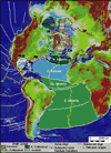
Topographic-bathymetric map of Atlantic-Arctic Oceans. The Gulf of Mexico and Canada Basin are located in back-arc settings, oriented at a high angle to the Paleo-Pacific subduction zone, and were never linked to the Atlantic seafloor. The pronounced wedge-shaped oceans are situated between North and South America and North America and Eurasia, respectively. Ap—Appalachian orogen; BB—Baffin Bay; Ca—Caledonian orogen; CB—Canada Basin; EB—Eurasia basin; GoM—Gulf of Mexico; In—Innuitian orogen; LS—Labrador Sea; MPB—Makarov-Podvodnikov Basin; NEA—Northeast Atlantic; O-M—Ouachita-Marathon orogen; Su—Suwanne suture; TS—Tyrrhenian Sea; Ur—Uralian orogen.
Differences also exist—in particular their paleo-latitudes during opening. The Gulf of Mexico opened between the Middle Jurassic and earliest Cretaceous and was located at a subtropical latitude, whereas the Canada Basin opened between Early and Late Cretaceous and was located close to 75° N. This difference is reflected by the presence of evaporites and carbonates in the Gulf of Mexico area, in contrast to siliciclastics in the Canada Basin (e.g., Shimeld et al., 2016). Another difference is the orientation of these oceans, with the Gulf of Mexico’s rift tip located toward the Atlantic and the Canada Basin’s toward the Pacific.
In all aspects, the Gulf of Mexico is the far better understood of the two basins, due to greater ease of access for data acquisition and its long and intensive history of petroleum exploration.
Gulf of Mexico Opening
Gulf of Mexico rifting started approximately in the Norian (228.4–209.5 Ma), marked by poorly dated red beds and volcanics of the Eagle Mills Formation (Moy and Traverse, 1986), approximately synchronous with rifting along the Central Atlantic margin along the U.S. East Coast (Olsen et al., 1996).
Modern interpretations of the continent- ocean boundary (COB) in the Gulf of Mexico range between two end-members. A “wide ocean” interpretation places COBs along the major (~200–300 nT) Houston, Florida, and Campeche magnetic anomalies (Imbert and Philippe, 2005), assumed by analogy with the Central Atlantic East Coast Magnetic Anomaly (ECMA) to represent a magma-rich margin (Holbrook et al., 1994; Imbert and Philippe, 2005) (Fig. 2). The alternative “narrower ocean” interpretation places COBs along the original limits of the Middle Jurassic Louann and Campeche salt bodies (e.g., Pindell and Kennan, 2009) (Fig. 2). These two salt bodies formed a contiguous evaporite basin in the Callovian (166.1–163.5 Ma) (e.g., Salvador, 1991). Although we lean toward the “wide ocean” interpretation, it is important to note that the alternative COB interpretations only influence the crustal type during the early phase of opening, not the kinematics or the resultant back-arc basin geometry.
Figure 2
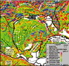
USGS magnetic data of Gulf of Mexico. GoM—Gulf of Mexico; COB—continent-ocean boundary; CMA—Campeche magnetic anomaly; FMA—Florida magnetic anomaly; HMA—Houston magnetic anomaly; CI—Chicxulub impact; ECMA—East Coast magnetic anomaly; TT—Tehuantepec transform. Lower Cretaceous carbonate platform after Winker and Buffler (1985). Large arrow illustrates the post–160 Ma rotational opening.
Like a number of previous workers (e.g., Molina-Garza et al., 1992; Marton and Buffler, 1994; Imbert and Philippe, 2005; Pindell and Kennan, 2009; Kneller and Johnson, 2011; Rowan, 2014) we favor a two-phase opening model for the Gulf of Mexico:
Phase 1 (Fig. 3A): Magma-rich break-up, governed by separation of Gondwanaland and Laurentia, marked by the large positive magnetic anomalies and seaward-dipping reflectors (SDRs), followed by a gradual transition to normal oceanic crust. During this phase, Yucatan was attached to, and moving with, the rest of Gondwanaland, and the Gulf of Mexico opening was only weakly rotational with the Yucatan block sliding along the proto-Florida Escarpment and proto-Tehuantepec transform. The fit between the Houston and Campeche magnetic anomalies, by comparison with the Atlantic ECMA (e.g., Labails et al., 2010), may indicate Early Jurassic opening. This fit also aligns a prominent linear magnetic anomaly crossing Yucatan (Fig. 3) with the similar anomaly marking the Appalachian fold belt front (Steltenpohl et al., 2013).
Figure 3
(A) Pre-opening reconstruction of the magnetic grid, restoring the Houston and Campeche magnetic anomalies. Note the alignment of the Appalachian frontal positive anomaly with a linear positive anomaly across Yucatan, suggestive of a good fit and a continuation of the orogen across Yucatan. Arrow indicates direction that Yucatan will become pulled with Gondwanaland away from North America. (B) 160 Ma reconstruction marking the transition between the mainly translational motion and subsequent pronounced rotation around a rotation pole in the Florida Straits area. ECMA—East Coast magnetic anomaly.
Phase 2 (Fig. 3B): Pronounced counter-clockwise (CCW) rotation of Yucatan about a pole in the Florida Straits, splitting the once-contiguous Callovian salt basin. Seafloor spreading during this phase is now widely accepted due, for example, to satellite gravity data (Sandwell et al., 2014). These data reveal abandoned spreading axis segments and fracture zones constraining the post-salt kinematics. Paleomagnetic data (e.g., Molina-Garza et al., 1992) indicate that Yucatan rotated 78 ± 11º CCW since the Permian, of which 63º occurred after Middle Jurassic. This rotation is reflected by the fracture zones imaged by satellite gravity data. Spreading termination probably occurred in the Berriasian (145.0–139.4 Ma), based on ODP Leg 77 boreholes in the Florida Strait (Marton and Buffler, 1994). Synchronously with the counter-clockwise rotation of Yucatan, complementary clockwise fan-shaped spreading probably took place in the proto-Caribbean (e.g., Pindell and Kennan, 2009).
The Tehuantepec transform in western Gulf of Mexico (Figs. 2 and 3B) marks the terminal shear to Gulf of Mexico rotational opening, and forms a classic sharp transition between continental and oceanic crust (Román Ramos et al., 2009). Straddling the transform is a thick Cenozoic apron, deformed at the updip end by the Neogene Quetzalcoatl extensional system, which is linked via detachments with the contractional Mexican Ridges fold and thrust belt (e.g., Salomón-Mora et al., 2009).
Regardless of preferred fit and timing, it is clear from refraction surveys that the Gulf of Mexico is underlain by thin crust (e.g., Marton and Buffler, 1994; Eddy et al., 2014), with substantial swathes of oceanic crust developing in a back-arc setting to the Paleo-Pacific (Stern and Dickinson, 2010) at an unusually high angle to the line of subduction.
Canada Basin Opening
The Canada Basin margins experienced significant rifting in the Kimmeridgian (157.3–152.1 Ma) (Dixon, 1982). Barremian (130.8–126.3 Ma) break-up was coincident with major dike swarms in the Canadian Arctic Island area, Svalbard, and Franz Josef Land. Ages range between ca. 138 and 125 Ma, but appear dominated by ca. 125 Ma high-precision U/Pb geochronology (e.g., Corfu et al., 2013; Døssing et al., 2013; Polteau et al., 2015). Break-up is also marked by a pronounced regional unconformity in the Mackenzie Delta–Beaufort Sea and North Slope of Alaska (e.g., Bird and Houseknecht, 2011). The Canada Basin is underlain by thin crust (e.g., Alvey et al., 2008; Chian et al., 2016; Doré et al., 2016; Mosher et al., 2016) and has been interpreted to have magma-poor margins, with exhumed mantle, flanking a central area with oceanic crust (Grantz et al., 2011; Chian et al., 2016).
The Arctic is comparatively data-poor due to its remoteness and harsh climate, and several vastly different plate models have been proposed (older models summarized by Lawver and Scotese, 1990). Recently acquired data (e.g., Gottlieb et al., 2014; Mosher et al., 2016) underpin modern models (e.g., Alvey et al., 2008; Whittaker and Ady, 2015; Doré et al., 2016). These are mostly a variation of the “windshield wiper” model (Hamilton, 1970; Grantz et al., 1979), whereby the Canada Basin opened by ~66º CCW rotation of a microcontinental fragment (Alaska-Chukotka), away from the Canadian Arctic margin, simultaneously closing the South Anyui Sea, a former arm of the paleo-Pacific Ocean between North America and Eurasia (Figs. 4A and 4B). Differences between modern models mainly relate to the size and nature of crustal domains in the Canada Basin and adjacent Arctic Ocean (oceanic crust, exhumed mantle, and hyperextended continental crust). These interpretations variously utilize gravity inversion of crustal thickness (Alvey et al., 2008), seismic mapping (Nikishin et al., 2014), analysis of seismic refraction velocities (Chian et al., 2016), and integration of all of these techniques with gravity and magnetic data (e.g., Gaina et al., 2011). While the different approaches affect the interpreted location of the distal transform, the kinematic solution with a counter-clockwise rotational opening of the Canada Basin is similar. The rift tip of the Canada Basin rotation was located in the Mackenzie Delta area, while the distal transform ran along the proto-North Barents and Kara Sea margin, either tracking the Alpha Ridge (Doré et al., 2016; see also Figs. 4A and 4B) or the Lomonosov Ridge (Grantz et al., 1979; Evangelatos and Mosher, 2016). The rifted margins of the North American craton and the Alaska-Chukotka terrane made up the lateral boundaries. Recent models show that this rotation was succeeded by a Late Cretaceous phase of spreading, orthogonal to the previous direction, forming the Makarov-Podvodnikov Basin, which thus interposes between the Early Cretaceous Canada Basin and the Cenozoic Eurasia Basin (Fig. 1) (cf. Doré et al., 2016; Whittaker and Ady, 2015; Nikishin et al., 2014).
Figure 4

(A) 125 Ma pre-breakup plate reconstruction of Canada Basin (CB). (B) 80 Ma reconstruction. Note that CB is not linked with the Atlantic. ChB—Chukchi Borderlands; LS—Labrador Sea. For details, see Doré et al. (2016).
Termination of Canada Basin seafloor spreading is not well constrained. The Canada Basin has a distinct abandoned spreading axis, revealed by gravity data, and a few weak linear magnetic anomalies on either side of the ridge (Doré et al., 2016; Chian et al., 2016; Mosher et al., 2016). We interpret these magnetic anomalies as isochrons formed shortly after the Cretaceous magnetic quiet period (i.e., after 83.5 Ma), indicating that spreading ended at ca. 80 Ma (Fig. 4B). The amount of rotation is supported by paleomagnetic data from the Alaska margin (Halgedahl and Jarrard, 1987), and the resulting reconstruction is supported by detrital zircon data from the conjugate margins (Gottlieb et al., 2014).
Gulf of Mexico Basin Confinement
The Gulf of Mexico’s evaporite basin must represent confinement from the world’s oceans. The evaporites are mainly halite, and their age is constrained by overlying and underlying strata to approximately Callovian (e.g., Salvador, 1991; Marton and Buffler, 1994). Overlying the evaporites are eolian sands of the Norphlet Formation, in turn overlain by Kimmeridgian Smackover carbonate source rocks, followed by the Buckner Anhydrite. The basin-wide marine Tithonian (152.1–145.0 Ma) source rock (e.g., Cole et al., 2001; Holguín-Quiñones et al., 2005) was deposited next.
Evaporite deposition over oceanic crust was suggested by Marton and Buffler (1994) and Imbert and Philippe (2005), and indirectly implied by the mapping of oceanic crust under much of the northern Gulf of Mexico by Kneller and Johnson (2011). A magma-poor early development of the Gulf of Mexico (as proposed by e.g., Kneller and Johnson, 2011; Rowan, 2014) means that the evaporites must have formed on exhumed mantle and/or hyperextended crust. For all of these models, the basin floor must inevitably have subsided to great depths at the time of evaporation based on the general principles of isostasy (cf. Karner et al., 2012; Mohn et al., 2015). For the basin to have remained shallow (e.g., Marton and Buffler, 1994; Rowan, 2014), an unknown mechanism would be required. It thus seems more likely that the evaporites formed significantly below global base level by drawdown, analogously to the Mediterranean and Red Sea during the Messinian (7.25–5.83 Ma) crisis (e.g., Imbert and Philippe, 2005; Ryan, 2008), with rapid flooding rather than rapid basin deepening governing the deposition of the succeeding Smackover Formation (e.g., Heydari et al., 1997). Horbury et al. (2003) describe rapid base-level changes during the Late Jurassic, of magnitudes not readily explained by eustatic changes, and attribute these to tectonic forcing. In addition to possible breaching and rapid influx of water to the Gulf of Mexico during the Kimmeridgian, the basin-wide Tithonian source rock is a candidate for deposition during rapid influx of sea water into a confined (silled) basin, possibly analogous to the organic-rich sediments formed in the confined Holocene Black Sea (cf. Arthur and Sageman, 2004). Given the geometry of the Gulf of Mexico back-arc basin, it appears reasonable that tectonic forcing could cause both periodic closing and breaching of marine connections. The alternative, rapid whole-scale basin subsidence/uplift or eustatic sea-level changes, appears more difficult to explain.
Renewed confinement and drawdown of the Gulf of Mexico has been proposed during the Paleocene-Eocene (66.0–33.9 Ma), related to docking of Cuba and closing off of the Gulf of Mexico’s Atlantic connection in the Florida Strait (Rosenfeld and Pindell, 2002). Support for this interpretation includes major canyon cutting, karstification, sequence boundaries unrelated to worldwide eustatic changes, and coal beds immediately underlain and overlain by bathyal sediments (Rosenfeld and Blickwede, 2006; Cossey et al., 2016).
Canada Basin Confinement
The Arctic Ocean (Canada Basin, Makarov-Podvodnikov Basin, and Eurasia Basin) was periodically cut off from, or poorly connected to, the world’s oceans until the middle Miocene (ca. 17.5 Ma) opening of the Arctic Gateway along the Fram Strait (Jakobsson et al., 2007).
Early Cretaceous confinement events include the organic-rich Barremian Pebble Shale and Gamma Ray Zone of the Hue Shale, which were deposited immediately following Canada Basin break-up. These source rocks are observed to become richer toward the Canada Basin (Bird and Houseknecht, 2011). In the Late Cretaceous, the Arctic Ocean connected with the North American Western Interior Seaway (Arthur and Sageman, 2004), but significant local restriction is indicated by the organic-rich shales of the Smoking Hills, Boundary Creek, and Kanguk Formations, which constitute important source rocks (e.g., Houseknecht and Bird, 2011).
An indisputable period of basin confinement is marked by the early Eocene Azolla event (ca. 50 Ma) discovered by the Arctic Coring Expedition (e.g., Backman and Moran, 2009). During this interval, the Arctic Ocean was a very large isolated freshwater tract with prolific growth of the freshwater fern Azolla. Bujak and Bujak (2014) write that, at this time, the Arctic Ocean was an isolated, silled basin analogous to today’s Black Sea. Paleogene organic-rich shales near the North Pole reported by Stein (2007), and the Aklak, Taglu, Richards, and Kugmalit Paleogene prodelta source rock intervals in the Mackenzie Delta (e.g., Brooks, 1986), also suggest clastic input into a confined basin with episodic water stratification and anoxia.
Discussion
Empirical similarities between the Gulf of Mexico and the Canada Basin suggest a causal relationship and a similar mechanism of formation. These similarities are as follows:
- The overall geometry of the basins, characterized by a triangular shape and high angle of rotation (~70°);
- Their location in a back-arc setting relative to the subducting paleo-Pacific;
- Their resultant spreading ridges trending almost normal to the arc, i.e., approximately in the subduction direction, albeit with the rift tips and opposing transform margins reversed for the two basins (Fig. 1); and
- Their position at the intersection, along the paleo-Pacific margin, of North America with other major Pangean cratonic masses to the north (Siberia) and south (South America).
As indicated in the introduction to this paper, mechanisms for back-arc basin formation mainly imply extensional basin formation parallel to the subduction zone, and do not readily explain the development of highly oblique to orthogonal back-arc basins such as the Gulf of Mexico or Canada Basin. Elsewhere on the globe, both the Tyrrhenian Basin in the Mediterranean and the South China Sea appear analogous to Gulf of Mexico and Canada Basin, in that they are triangular and occupy back-arc settings with spreading approximately orthogonal to the prevailing subduction. Both of these spreading cells are thought by some workers to relate to continental collision. Tyrrhenian Basin spreading has been related to indentation of Africa into Eurasia (Faccena et al., 1996), while the South China Sea has been related to extrusion tectonics from India’s indentation into Eurasia (e.g., Tapponnier et al., 1986). However, an indentation mechanism of this type is not available to explain the formation of either the Gulf of Mexico or Canada Basin.
A general explanation for the formation of high-angle back-arc basins may be a manifestation of the Wilson Cycle; in this case, the reactivation of weak Paleozoic Pangean suture zones in a back-arc stress regime, where these sutures intersect the paleo-Pacific margin. Notably, both the Innuitian fold belt of Arctic Canada (essentially a continuation of the Caledonian fold belt; e.g., Ohta et al., 1989) and the Urals-Novaya Zemlya-Taimyr fold belt of Russia (e.g., Puchkov, 2013) intersected the paleo-Pacific where the Canada Basin later developed (Fig. 4A). To the south, the Gulf of Mexico formed where the Suwanne and Appalachian-Ouachita-Marathon sutures converged on the Pacific margin (e.g., Parker, 2014; Thomas, 2006). In the Mesozoic, these unusual basins then occupied the space between subduction zones from adjacent continental masses, and their formation may therefore also relate to interaction between adjacent descending slabs. Testing the viability of such speculative mechanisms requires further study, including modeling of lithosphere-mantle dynamics.
The tendency toward restriction in both basins was predisposed by their mode of formation and resulting geometries. Simple rules of plate tectonics require that the amount of extension is reduced toward the rotation pole (e.g., Cox and Hart, 1986), and likewise so would subsidence governed by crustal thinning (e.g., McKenzie, 1978). Beyond the rift tip there is no extension, and subsidence should not be expected. The tip of the Gulf of Mexico’s oceanic crust never connected with the oceanic crust of the Atlantic, while the transform boundary at the distal end was separated from the Pacific by continental terranes and a major volcanic arc (e.g., Dickinson and Lawton, 2001). Pacific seawater did not reach the Gulf of Mexico until the Middle Jurassic, while connection with the Atlantic was only achieved in the Late Jurassic (Salvador, 1987). Breaching of the rift tip in the Florida Strait (Schlager et al., 1984) generated the incursion that flooded the eolian Nophlet Formation, causing the rapid sea-level rise associated with deposition of the Smackover source rock (Heydari et al., 1997). The lateral boundaries to the pie-shaped ocean, the rifted margin of North American and the Yucatan microcontinent grade into thick continental crust, which remain elevated to this day. The pie-shaped oceanic Gulf of Mexico, graded into thick continental crust in all directions, and marine connections with the world ocean appear to have been sensitive to tectonic forcing, especially during the Late Jurassic (Horbury et al., 2003).
Similarly, the Canada Basin rift tip in the Mackenzie Delta area was located in the Cordillera hinterland and never connected with the Pacific. The lateral boundaries of the Canada Basin, the North American craton, and the Alaska-Chukotka terrane represent thick continental crust that has remained elevated, and the transform margin was located against Eurasian continental crust. Connection via the Western Interior Seaway to the Gulf of Mexico in the Late Cretaceous was governed by the Cordilleran foreland basin flexuring (e.g., Jordan, 1981), but even this connection was prone to periodic confinement during the Cenomanian-Turonian (100.5–89.8 Ma) (Arthur and Sageman, 2004). Deep ventilation between the Arctic Ocean and the Atlantic was not initiated until middle Miocene time, when the Arctic Gateway in the Fram Strait opened (Jakobsson et al., 2007), as a consequence of oblique opening along the De Geer Transform (e.g., Doré et al., 2016).
Thus, the first-order characteristics shared by the Gulf of Mexico and Canada Basin siblings have been critical in the geological history of the North American continent, and to its prolific petroleum resources. Both basins were confined for much of their early history with obvious implications for organic-rich deposits, and, in the case of the Canada Basin, with possible major implications for global climate via the early Eocene Azolla bloom, which may have tipped Earth’s climate from the Cretaceous and Paleocene “Super Greenhouse” into the “Ice House” climate that remains today (e.g., Moran et al., 2006; Bujak, 2007; Bujak and Bujak, 2014). In the Cenozoic, both basins formed massive depositional sinks for Laramide erosion products at either end of the continent and housed the two great North American deltas (the Mississippi and Mackenzie).
In conclusion, we propose that both the Gulf of Mexico and Canada Basin re-opened Late Paleozoic sutures between major continents, these sutures intersecting the paleo-Pacific margin at a high angle. Such small, highly rotational oceans, opening at a high angle to the subduction direction in back-arc settings (Fig. 5) could therefore constitute a lesser-known manifestation of the Wilson Cycle. This mode of formation may provide an alternative mechanism for development of other Pacific rim ocean basins, such as the South China Sea and possibly the Weddell Sea of Antarctica. Because their geometry governs periodic confinement, and has influenced global climate as well as source and reservoir rock distribution, there is significant environmental and economic incentive to understanding the genesis and common factors of these basins.
Figure 5
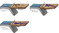
(A) Schematic illustration of classic back-arc basin experiencing trench-parallel extension. (B and C) Back-arc basin opening at high angle to the trench. The latter represents, for example, the Gulf of Mexico and the Canada Basin, and reveals why such basins are prone to confinement; these small oceans are surrounded by continental crust. EP—Euler pole. Preexisting Late Paleozoic sutures are shown schematically with a purple hatched pattern and are interpreted to have caused weaknesses that were exploited. Modified after Heuret and Lallemand (2005).
Acknowledgments
We thank Ana Gibbons for assistance with plate reconstructions and Christian Gram for assistance with the Gulf of Mexico magnetic data. We thank reviewers Mike Gurnis, Sergey Drachev, and Dave Mosher for constructive suggestions that improved the paper considerably.
References
- Alvey, A., Gaina, C., Kusznir, N.J., and Torsvik, T.H., 2008, Integrated crustal thickness mapping and plate reconstructions for the high Arctic: Earth and Planetary Science Letters, v. 274, p. 310–321, doi: 10.1016/j.epsl.2008.07.036.
- Arthur, M.A., and Sageman, B.B., 2004, Sea-level control on source-rock development: Perspectives from the Holocene Black Sea, the Mid-Cretaceous Western Interior Basin of North America, and the Late Devonian Appalachian Basin, in Harris, N.B., ed., The Deposition of Organic-Carbon-Rich Sediments: Models, Mechanisms, and Consequences: SEPM Special Publication 82, p. 35–59.
- Backman, J., and Moran, K., 2009, Expanding the Cenozoic paleoceanographic record in the Central Arctic Ocean: IODP Expedition 302 Synthesis: Central European Journal of Geosciences, v. 1, p. 157–175, doi: 10.2478/v10085-009-0015-6.
- Bird, K.J., and Houseknecht, D.W., 2011, Geology and petroleum potential of the Arctic petroleum province, in Spencer, A.M., Embry, A.F., Gautier, D., Stoupakova, A.V., and Sørenson, K., eds., Arctic Petroleum Geology: Geological Society, London, Memoir 35, p. 485–499.
- Brooks, P.W., 1986, Unusual biological marker geochemistry of oils and possible source rocks, offshore Beaufort-Mackenzie Delta, Canada: Organic Geochemistry, v. 10, p. 401–406, doi: 10.1016/0146-6380(86)90039-2.
- Bujak, J.P., 2007, The Azolla Story: Climate change and Arctic hydrocarbons: GeoExpro Magazine, v. 4, p. 66–72.
- Bujak, J.P., and Bujak, A., 2014, The Arctic Azolla Event: Geoscientist, v. 24, no. 5, p. 10–15.
- Chian, D., Jackson, H.R., Hutchinson, D.R., Shimeld, J.W., Oakey, G.N., Lebedeva-Ivanova, N., Li, Q., Saltus, R.W., and Mosher, D.C., 2016, Distribution of crustal types in Canada Basin, Arctic Ocean: Tectonophysics, p. 8–30, doi: 10.1016/j.tecto.2016.01.038.
- Cole, G.A., Yu, A., Peel, F., Requejo, R., DeVay, J., Brooks, J., Bernard, B., Zumberge, J., and Brown, S., 2001, Constraining source and charge risk in deepwater areas: WorldOil.com online magazine, v. 222, p. 1–15.
- Corfu, F., Polteau, S., Planke, S., Faleide, J.I., Svensen, H., Zayoncheck, A., and Stolbov, N., 2013, U-Pb geochronology of Cretaceous magmatism on Svalbard and Franz Josef Land, Barents Sea Large Igneous Province: Geological Magazine, v. 150, p. 1127–1135, doi: 10.1017/S0016756813000162.
- Cossey, S.P.J., van Nieuwenhuise, D., Davis, J., Rosenfeld, J.H., and Pindell, J., 2016, Compelling evidence from eastern Mexico for a Late Paleocene/Early Eocene isolation, drawdown, and refill of the Gulf of Mexico: Interpretation (Tulsa), v. 4, no. 1, SC63, doi: 10.1190/INT-2015-0107.1.
- Cox, A., and Hart, B., 1986, Plate Tectonics: How it Works: Boston, Blackwell Scientific, 392 p.
- Dickinson, W.R., and Lawton, T.F., 2001, Carboniferous to Cretaceous assembly and fragmentation of Mexico: GSA Bulletin, v. 113, p. 1142–1160, doi:10.1130/0016-7606(2001)113<1142:CTCAAF>2.0.CO;2.
- Dixon, J., 1982, Jurassic and Lower Cretaceous subsurface stratigraphy of the Mackenzie Delta-Tuktoyaktuk Peninsulas, N.W.T.: Bulletin of the Canadian Geological Survey, 349, 52 p.
- Dixon, J., Dietrich, J.R., Lane, L.S., and McNeil, D.H., 2008, Geology of the Late Cretaceous to Cenozoic Beaufort-Mackenzie Basin, Canada, Sedimentary Basins of the World, 5, Elsevier, p. 552–571, doi: 10.1016/S1874-5997(08)00016-6.
- Doré, A.G., Lundin, E.R., Gibbons, A., Sømme, T.O., and Tørudbakken, B.O., 2016, Transform margins of the Arctic: A synthesis and re-evaluation, in Nemčok, M., Rybár, S., Sinha, S.T., Hermeston, S.A., and Ledvényiová, L., eds., Transform Margins: Development, Controls and Petroleum Systems: Geological Society, London, Special Publication 431, p. 63–94, doi: 10.1144/SP431.8.
- Døssing, A., Jackson, R.H., Matzka, J., Einarsson, I., Rasmussen, T.M., Olesen, A.V., and Brozena, J.M., 2013, On the origin of the Amerasia Basin and the High Arctic Large Igneous Province—Results of new aeromagnetic data: Earth and Planetary Science Letters, v. 363, p. 219–230, doi: 10.1016/j.epsl.2012.12.013.
- Eddy, D.R., Van Avendonk, H.J.A., Christesen, G.L., Norton, I.O., Karner, G.D., Johnson, C.A., and Snedden, J.W., 2014, Deep crustal structure of the northeastern Gulf of Mexico: Implications for rift evolution and seafloor spreading: Journal of Geophysical Research, v. 119, p. 6802–6822, doi: 10.1002/2014JB011311.
- Evangelatos, J., and Mosher, D.C., 2016, Seismic stratigraphy, structure and morphology of Makarov Basin and surrounding regions: Tectonic implications: Marine Geology, v. 374, p. 1–13, doi: 10.1016/j.margeo.2016.01.013.
- Faccenna, C., Davy, P., Brun, J.-P., Funiciello, R., Giardini, D., Mattei, M., and Nalpas, T., 1996, The dynamics of back-arc extension: An experimental approach to the opening of the Tyrrhenian Sea: Geophysical Journal International, v. 126, p. 781–795, doi: 10.1111/j.1365-246X.1996.tb04702.x.
- Gaina, C., Werner, S.C., Saltus, R., and Maus, S., the CAMP-GMGROUP, 2011, Chapter 3 Circum-Arctic mapping project: New magnetic and gravity anomaly maps of the Arctic, in Spencer, A.M., Embry, A.F., Gautier, D.L., Stoupakova, A.V., and Sørensen, K., eds., Arctic Petroleum Geology: Geological Society, London, Memoir 35, p. 39–48, doi: 10.1144/M35.3.
- Galloway, W.E., Caney-Curry, P.E., Li, X., and Buffler, R.T., 2000, Cenozoic depositional history of the Gulf of Mexico basin: AAPG Bulletin, v. 84, p. 1743–1774.
- Gottlieb, E.S., Meisling, K.E., Miller, E.L., and Mull, C.G., 2014, Closing the Canada Basin: Detrital zircon geochronology relationships between the North Slope of Arctic Alaska and the Franklinian mobile belt of Arctic Canada: Geosphere, v. 10, p. 1366–1384, doi: 10.1130/GES01027.1.
- Grantz, A., Eittreim, S., and Dinter, D.A., 1979, Geology and tectonic development of the continental-margin north of Alaska: Tectonophysics, v. 59, p. 263–291, doi: 10.1016/0040-1951(79)90050-7.
- Grantz, A., Hart, P., and Childers, V.A., 2011, Geology and tectonic development of the Amerasia and Canada Basins, Arctic Ocean, in Spencer, A.M., Embry, A.F., Gautier, D.L., Stoupakova, A.V., and Sørensen, K., eds., Arctic Petroleum Geology: Geological Society, London, Memoir 35, p. 771–799, doi: 10.1144/M35.50.
- Halgedahl, S., and Jarrard, R., 1987, Paleomagnetism of the Kuparuk River formation from oriented drill core: Evidence for rotation of the Arctic Alaska plate, in Tailleur, I., and Weimer, P., eds., Alaskan North Slope Geology, Pacific Section, SEPM, v. 2, p. 581–617.
- Hamilton, W., 1970, The Uralides and the motion of the Russian and Siberian platforms: GSA Bulletin, v. 81, p. 2553–2576, doi:10.1130/0016-7606(1970)81[2553:TUATMO]2.0.CO;2.
- Heydari, E., Wade, W.J., and Anderson, L.C., 1997, Depositional environments, organic carbon accumulation, and solar-forcing cyclicity in Smackover Formation lime mudstones, northern Gulf Coast: AAPG Bulletin, v. 81, p. 760–774.
- Holbrook, S.W., Purdy, G.M., Sheridan, R.E., Glover, L., III, Talwani, M., Ewing, J., and Hutchinson, D., 1994, Seismic structure of the US Mid-Atlantic continental margin: Journal of Geophysical Research, v. 99, p. 17,871–17,891, doi: 10.1029/94JB00729.
- Holguín-Quiñones, Brooks, J.M., Román-Ramos, J.R., Bernards, B.B., Lara-Rodrigues, J., Zumberge, J.E., Medrano-Morales, L., Rosenfeld, J., De Fargó Botella, M., Maldanado-Villalón, R., and Martínez-Pontvianne, 2005, Estudio regional de manifestaciones superficilaes de acete y gas en el Sur del Golfo de México, su origen e implicaciones exploratorias: Boletín de la Asociación Mexicana de Geólogos Petroleros, v. 52, p. 20–41.
- Horbury, A.D., Hall, S., González,-P., F., Rodríguez-F., D., Reyes-F., A., Ortiz-G., P., Martínez-M., M., and Quintanilla-R., G., 2003, Tectonic sequence stratigraphy of the western margin of the Gulf of Mexico in the late Mesozoic and Cenozoic: Less passive than previously imagined, in Bartolini, C., Buffler, R.T., and Blickwde, J., eds., The Circum-Gulf of Mexico and the Caribbean: Hydrocarbon Habitats, Basin Formation, and Plate Tectonics: AAPG Memoir 79, p. 184–245.
- Houseknecht, D.W., and Bird, K.J., 2011, Geology and petroleum potential of the rifted margins
- of the Canada Basin, in Spencer, A.M., Embry, A.F., Gautier, D.L., Stoupakova, A.V., and Sørensen, K., eds., Arctic Petroleum Geology: Geological Society, London, Memoir 35, p. 509–526, doi: 10.1144/M35.34.
- Hueret, A., and Lallemand, S., 2005, Plate motions, slab dynamics and back-arc deformation: Physics of the Earth and Planetary Interiors, v. 149, p. 31–51, doi: 10.1016/j.pepi.2004.08.022.
- Imbert, P., and Philippe, Y., 2005, The Mesozoic opening of the Gulf of Mexico: Part 2. Integrating seismic and magnetic data into a general opening model, in Post, P.J., Rosen, N.C., Olson, D.L., Palmes, S.L., Lyons, K.T., and Newton, G.B., eds., Transactions of the 25th Annual GCSSEPM Research Conference: Petroleum Systems of Divergent Continental Margins, p. 1151–1189.
- Jakobsson, M., Backman, J., Rudels, B., Nycander, J., Frank, M., Mayer, L., Jokat, W., Sangiorgi, F., O’Regan, M., Brinkhuis, H., King, J., and Moran, K., 2007, The early Miocene onset of a ventilated circulation regime in the Arctic Ocean: Nature, v. 447, p. 986–990, doi: 10.1038/nature05924.
- Jordan, T.E., 1981, Thrust loads and foreland basin evolution, Cretaceous, western United States: AAPG Bulletin, v. 65, p. 2506–2520.
- Karner, G.D., Johnson, C.A., Mohn, G., and Manatschal, G., 2012, Depositional environments and source distribution across hyperextended rifted margins of the North Atlantic: Insights from the Iberia-Newfoundland margin: Trinity College Dublin, Third Central & North Atlantic Conjugate Margin Conference, 22–24 Aug. 2012, p. 7–17.
- Kneller, E.A., and Johnson, C.A., 2011, Plate kinematics of the Gulf of Mexico based on integrated observations from the Central and South Atlantic: Gulf Coast Association of Geological Societies Transactions, v. 61, p. 283–299.
- Labails, C., Olivet, J.-L., Aslanian, D., and Roest, W.R., 2010, An alternative early opening scenario for the Central Atlantic Ocean: Earth and Planetary Science Letters, v. 297, p. 355–368, doi: 10.1016/j.epsl.2010.06.024.
- Lawver, L.A., and Scotese, C.R., 1990, A review of tectonic models for the evolution of the Canada Basin, in Grantz, A., Johnson, G.L., and Sweeney, J.F., eds., The Arctic Ocean region: Boulder, Colorado, Geological Society of America, Geology of North America, v. L, p. 593–618.
- Marton, G., and Buffler, R.T., 1994, Jurassic reconstruction of the Gulf of Mexico Basin: International Geology Review, v. 36, p. 545–586, doi: 10.1080/00206819409465475.
- McKenzie, D.P., 1978, Some remarks on the development of sedimentary basins: Earth and Planetary Science Letters, v. 40, p. 25–32, doi: 10.1016/0012-821X(78)90071-7.
- Mohn, G., Karner, G., Manatchal, G., and Johnson, C.A., 2015, Structural and stratigraphic evolution of the Iberia-Newfoundland hyper-extended rifted margin: A quantitative modelling approach, in Gibson, G.M., Roure, F., and Manatschal, G., eds., Sedimentary Basins and Crustal Processes at Continental Margins: From Modern Hyper-Extended Margins to Deformed Ancient Analogues: Geological Society, London, Special Publication 413, p. 53–89, http://dx.doi.org/10.1144/SP413.9.
- Molina-Garza, R.S., Van Der Voo, R., and Urrutia-Fucugauchi, J., 1992, Evidence for rotation of the Maya Block and implications for the opening of the Gulf of Mexico: GSA Bulletin, v. 104, p. 1156–1168, doi:10.1130/0016-7606(1992)104<1156:POTCMS>2.3.CO;2.
- Moran, K., and 35 others, 2006, The Cenozoic palaeoenvironment of the Arctic Ocean: Nature, v. 441, p. 601–605, doi: 10.1038/nature04800.
- Mosher, D.C., Shimeld, J., Hutchinson, D., and Jackson, R., 2016, Canadian UNCLOS Extended Continental Shelf Program seismic reflection data holdings (2006–2011): Geological Survey of Canada Open File 7938 (digital) 8 pages, doi: 10.4095/297590.
- Moy, C., and Traverse, A., 1986, Palynostratigraphy of the subsurface Eagle Mills formation (Triassic) from a well in east-central Texas, USA: Palynology, v. 10, p. 225–234, doi: 10.1080/01916122.1986.9989310.
- Nikishin, A.M., Malyshev, N.A., and Petrov, E.I., 2014, Geological Structure and History of the Arctic Ocean: Houten, The Netherlands, EAGE Publications, 90 p.
- Ohta, Y., Dallmeyer, R.D., and Peucat, J.J., 1989, Caledonian Terranes in Svalbard: Geological Society of America Special Paper 230, p. 1–15, doi: 10.1130/SPE230-p1.
- Olsen, P.E., Kent, D.V., Cornet, B., Witte, W.K., and Schlische, R.W., 1996, High-resolution stratigraphy of the Newark rift basin (early Mesozoic, eastern North America): GSA Bulletin, v. 108, p. 40–77, doi:10.1130/0016-7606(1996)108<0040:HRSOTN>2.3.CO;2.
- Parker, E.H., Jr., 2014, Crustal magnetism, tectonic inheritance, and continental rifting in the southeastern United States: GSA Today, v. 24, p. 4–9, doi: 10.1130/GSAT-G192A.1.
- Pindell, J.L., and Kennan, L., 2009, Tectonic evolution of the Gulf of Mexico, Caribbean and northern South America in the mantle reference frame: an update: Geological Society, London, Special Publication 328, p. 1–55, doi: 10.1144/SP328.1.
- Polteau, S., Hendriks, B.W.H., Planke, S., Ganerød, M., Corfu, F., Faleide, J.I., Midtkandal, I., Svensen, H.S., and Myklebust, R., 2015, The Early Cretaceous Barents Sea Sill Complex: Distribution, 40Ar/39Ar geochronology, and implications for carbon gas formation: Palaeo-geography, Palaeoclimatology, Palaeoecology, doi: 10.1016/j.palaeo.2015.07.007.
- Puchkov, V.N., 2013, Structural stages and evolution of the Urals: Mineralogy and Petrology, v. 107, p. 3–37, doi: 10.1007/s00710-012-0263-1.
- Román Ramos, J.R., Cruz Mercado, M.A., Salomón Mora, L.E., and Lara, C.R., 2009. Structure in a Shear Margin: Western Main Transform, Offshore Veracruz, Southern Gulf of Mexico, in Bartolini, C., and Román Ramos, J.R., eds., Petroleum Systems in the Southern Gulf of Mexico: AAPG Memoir 90, p. 409–420.
- Rosenfeld, J., and Pindell, J., 2002, Latest Paleocene–Early Eocene isolation of the Gulf of Mexico from world oceans due to Cuba blocking the Florida Strait: A hypothesis to explain large-magnitude base level fall and resultant incision: Offshore Magazine, v. 62, pages 26, 28, 76.
- Rosenfeld, J., and Blickwede, J.F., 2006, Extreme evaporative drawdown of the Gulf of Mexico at the Paleocene-Eocene boundary: AAPG Annual Convention, Houston, Texas, April 9–12; AAPG Search and Discovery Article #30042(2006).
- Rowan, M.G., 2014, Passive-margin salt basins: Hyperextension, evaporate deposition, and salt tectonics: Basin Research, v. 26, p. 154–182, doi: 10.1111/bre.12043.
- Ryan, W.B.F., 2008, Modelling the magnitude and timing of evaporative drawdown during the Messinian salinity crisis: Stratigraphy, v. 5, p. 227–243.
- Salomón-Mora, L.E., Aranda-García, M., and Román-Ramos, J.R., 2009, Contractional growth faulting in the Mexican Ridges, Gulf of Mexico, in Bartolini, C., and Román Ramos, J.R., eds., Petroleum Systems in the Southern Gulf of Mexico: AAPG Memoir 90, p. 93–115.
- Salvador, A., 1987, Late Triassic–Jurassic paleo-geography and origin of Gulf of Mexico Basin: AAPG Bulletin, v. 71, p. 419–451.
- Salvador, A., 1991, Triassic-Jurassic, in Salvador, A., ed., The Gulf of Mexico Basin: Boulder, Colorado, Geological Society of America, Geology of North America, v. J, p. 131–180.
- Sandwell, D.T., Muller, D.R., Smith, W.H.F., Garcia, E., and Francis, R., 2014, New global marine gravity model from CryoSat-2 and Jason-1 reveals buried tectonic structure: Science, v. 346, p. 65–67, doi: 10.1126/science.1258213.
- Schlager, W., Buffler, R.T., Angstadt, D., and Phair, R., 1984, Geologic history of the southeastern Gulf of Mexico, in Buffler, R.T., and Schlager, W., Initial reports of the Deep Sea Drilling Project 77: Washington, D.C., U.S. Government Printing Office, p. 715–738, doi: 10.2973/dsdp
- .proc.77.132.1984.
- Shimeld, J., Li, Q., Chian, D., Lebedeva-Ivanova, N., Jackson, R., Mosher, D., and Hutchinson, D., 2016, Seismic velocities within the sedimentary succession of the Canada Basin and southern Alpha-Mendeleev Ridge, Arctic Ocean: Evidence for accelerated porosity reduction?: Geophysical Journal International, v. 204, p. 1–20, doi: 10.1093/gji/ggv416.
- Stein, R., 2007, Upper Cretaceous/lower Tertiary black shales near the North Pole: Organic-carbon origin and source-rock potential: Marine and Petroleum Geology, v. 24, p. 67–73, doi: 10.1016/j.marpetgeo.2006.10.002.
- Steltenpohl, M.G., Horton, J.W., Jr., Hatcher, R.D., Jr., Zietz, I., Daniels, D.L., and Higgins, M.W., 2013, Upper crustal structure of Alabama from regional magnetic and gravity data: Using geology to interpret geophysics, and vice versa: Geosphere, v. 9, p. 1044–1064, doi: 10.1130/GES00703.1.
- Stern, R.J., and Dickinson, W.R., 2010, The Gulf of Mexico is a Jurassic backarc basin: Geosphere, v. 6, p. 739–754, doi: 10.1130/GES00585.1.
- Tapponnier, P., Peltzer, G., and Armijo, R., 1986, Continent-continent collision: Himalayan-Alpine Belt, in Coward, M.P., and Ries, A.C., eds., Collision Tectonics: Geological Society London Special Publication 19, p. 115–157.
- Thomas, W.A., 2006, Tectonic inheritance at a continental margin: GSA Today, v. 16, p. 4–11, doi: 10.1130/1052-5173(2006)016[4:TIAACM]2.0.CO;2.
- Whittaker, R.C., and Ady, B.E., 2015, Implications for the timing, amount and direction of crustal extension in the eastern part of the Amerasia Basin from deformable plate reconstructions of the Labrador Sea–Baffin Bay and Northeast Atlantic: AAPG Arctic 3P Conference, Stavanger, Sept. 29–Oct. 2 2015.
- Winker, C.D., and Buffler, R.T., 1985, Paleogeographic evolution of the early deep-water Gulf of Mexico and margins, Jurassic to Middle Cretaceous (Comanchean): AAPG Bulletin, v. 72, p. 318–346.
