
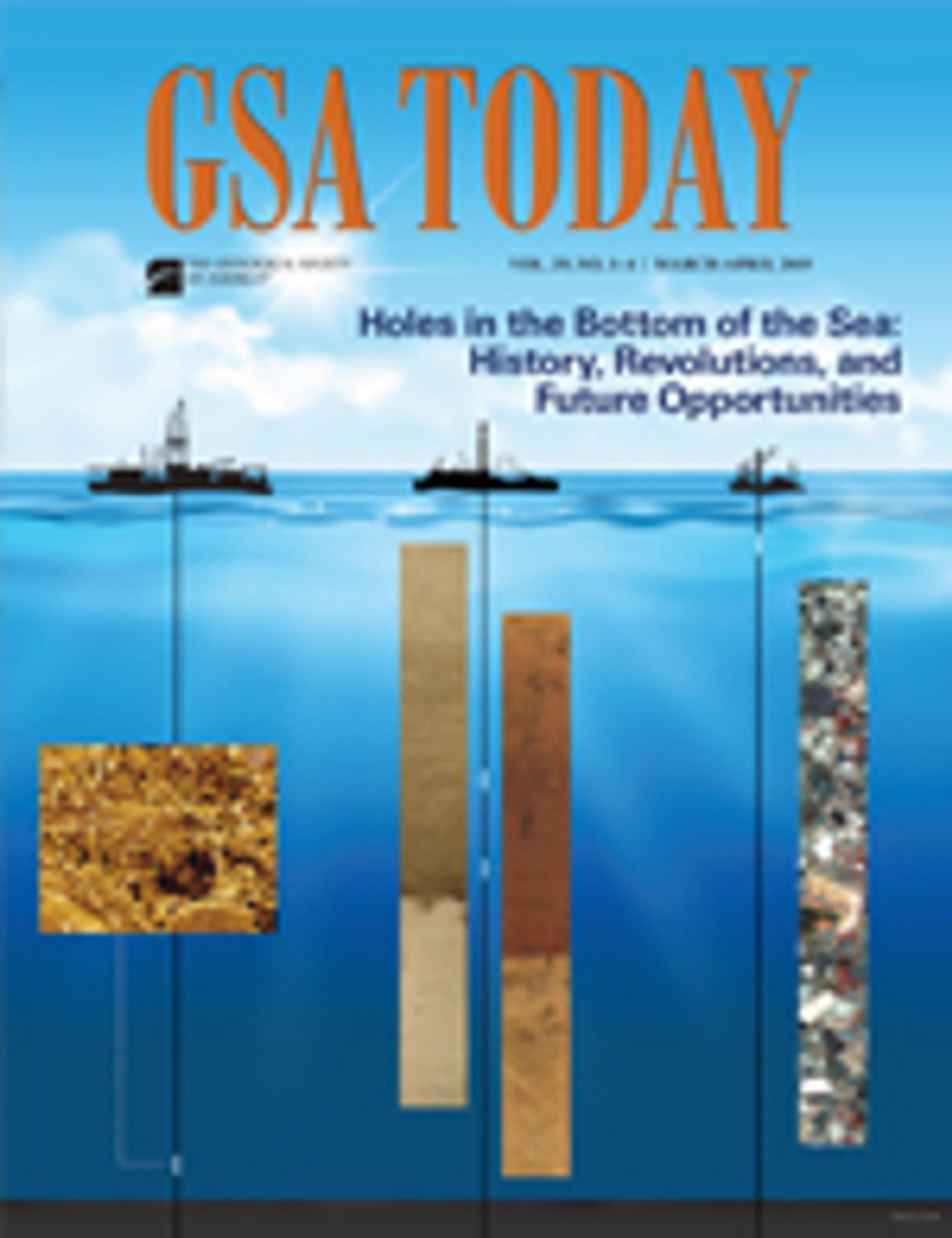
Holes in the Bottom of the Sea: History, Revolutions, and Future Opportunities
Suzanne OConnell
In this article
Authors
Suzanne OConnell
Professor of Earth & Environmental Sciences, Wesleyan University, Middletown, Connecticut 06459, USA, soconnell@wesleyan.edu
Abstract
No other international scientific collaboration has contributed as much to our knowledge of Earth processes as scientific ocean drilling (SOD). These contributions include geophysical surveys, core samples, borehole well logs, and sub-seafloor observatories. After more than half a century, involving thousands of scientists from around the world, SOD has been instrumental in developing three geoscience revolutions: (1) plate tectonics, (2) paleoceanography, and (3) the deep marine biosphere. Without SOD, it is unlikely that our current understanding of Earth processes could have developed. Building upon prior scientific results, the current science plan is guided by four interlinked themes: Planetary Dynamics, Climate and Ocean Change, Biosphere Frontiers, and Earth in Motion. SOD has also been a leader in international collaborations and the open sharing of samples, data, and information. Results from SOD expeditions are open access and available online. Almost 2.5 million samples have been taken from over 360 km of core located in three repositories. Today about half the members of scientific teams, including co-chief scientists, are women. This program is needed in the future for geoscientists to continue exploring our planet to understand how it functions and to create predictive models.
Manuscript received 12 July 2018. Revised manuscript received 26 Nov. 2018. Manuscript accepted 8 Dec. 2018. Posted 24 Jan. 2019.
© The Geological Society of America, 2019. CC-BY-NC.
https://doi.org/10.1130/GSATG380A.1
Introduction
Scientific ocean drilling (SOD) celebrated its 50th birthday in 2018. As of December 2018, 283 expeditions (formerly called legs) have been completed and >1600 sites have been drilled (see Fig. S1 in the GSA Data Repository1). These sites represent <0.0005% of the ocean floor, yet have provided essential information about plate tectonics, ocean chemistry, evolution, life in harsh environments, and climate change.
Scientists from across the world have benefited from and contributed to the program. Geophysical site survey data, cores, and associated information are available to the global scientific community to study and sample. More than 1000 international scientists, ranging in age from early career to retired, are proponents on active proposals for upcoming drilling.
This article, by no means comprehensive, highlights parts of the history and a few major discoveries of SOD. More complete histories are available in Ocean Drilling: Accomplishments and Challenges (National Research Council, 2011), Earth and Life Processes Discovered from Subseafloor Environments: A Decade of Science Achieved by the Integrated Ocean Drilling Program (IODP) (Stein et al., 2014), and Koppers et al. (2019). GSA Data Repository Table S1 (see footnote 1) provides URLs to detailed, preliminary information for all SOD expeditions and legs, including co-chief scientists, sites cored, and year.
-------
1GSA Data Repository item 2019051, Table S1 and Figures S1–S7, is available online at www.geosociety.org/datarepository/2019.
History
Pre-JOIDES (Joint Oceanographic Institutions for Deep Earth Sampling)
SOD may be said to have originated with the International Geophysical Year (1957–1958), and an organization with the unlikely name American Miscellaneous Society (AMSOC). AMSOC included men at pivotal positions at oceanographic institutions, oil companies, the Office of Naval Research, and the United States Geological Survey. Bascom (1961) provides details about AMSOC and the development of their discussions about SOD. Walter Munk (Scripps Institution of Oceanography [SIO]) and Harry Hess (Princeton University), both AMSOC members, proposed to drill a deep hole to sample Earth’s mantle below a zone of seismic velocity change, the Mohorovicic Discontinuity (Moho): “Project Mohole.”
The National Science Foundation (NSF) may have been in favor of the project, because the 1957 International Union of Geodesy and Geophysics Resolution 11 recommended that the Moho be drilled. The Soviet Union said they had the equipment and were looking for a place to drill (Bascom, 1961). They had just launched the Sputnik satellite. Their technological advance alarmed many Americans and spurred investment in U.S. science and technology.
Despite the difficulties of SOD, AMSOC, with NSF funding, took on the challenge. Many technological improvements were necessary for such a project: a drilling platform that could hold station in deep water and under different wave and wind conditions (dynamic positioning), a way to retrieve cores through drill pipe so that the drill pipe could stay in place, and a sturdy drill bit that could operate for days, even weeks. The first drilling was accomplished in 1961 with the barge, CUSS I (Continental, Union, Shell, and Superior). Unfortunately, after a promising start, organizational difficulties, and loss of political support, Project Mohole, deemed too expensive, was abandoned in 1966 (Hsü, 1992).
The Glomar Challenger
Not everyone agreed that drilling a single deep hole in igneous rock was the best initial SOD research objective. In 1962, Cesare Emiliani (University of Miami) proposed that a drilling vessel be deployed to core continuously through deep-sea sediment (project LOCO, LOng COres). Maurice Ewing (Columbia University, also a member of AMSOC) supported obtaining multiple long cores, stating, “The entire record of terrestrial conditions from the beginning of the ocean is there in the most undisturbed form it is possible to find anywhere—and the dream of my life is to punch that hole 2000 feet deep and bring the contents to the lab to study them” (Gray, 1956).
Thus, simultaneously with Project Mohole, a different kind of program was planned. Five U.S. oceanographic institutions established JOIDES (Joint Ocean-ographic Institutions for Deep Earth Sampling). In 1965, using dynamic positioning, fourteen holes were cored in the eastern Atlantic Ocean on board the Caldrill I. The results convinced the scientific community of the value of multiple holes throughout the ocean. In 1967, Global Marine was contracted to design a ship expressly for the purpose of SOD. With SIO as the prime contractor, the Deep Sea Drilling Project (DSDP), using the Glomar Challenger, was launched (Bascom, 1961).
Deep Sea Drilling Project (DSDP, 1968–1983)
By 1968, several seminal papers on plate tectonics (e.g., Hess, 1962; Vine and Matthews, 1963; Wilson, 1966) had been published. These papers were based on sparse data, leaving many unconvinced. Interpretation of marine magnetic anomalies (e.g., Pitman et al., 1968) and better earthquake data (e.g., Isacks et al., 1968) provided additional support for this theory. For many, final confirmation came from SOD.
As with Project Mohole, whose objective was seismically defined, Leg 1 of the Glomar Challenger and all subsequent expeditions have used seismic surveys to determine the ideal place to drill for science (Fig. 1) and for safety reasons, such as avoiding overpressured hydrocarbons. Leg 1’s objectives in the central Gulf of Mexico were clear; identify the cause of the reflectors on the seismic profiles, especially the domes and knolls on the deep-sea floor, and recover the oldest ocean sediment. Leg 1 of DSDP was a success. The domes were salt diapirs. The oldest sediment was Jurassic, much younger than expected.
Figure 1
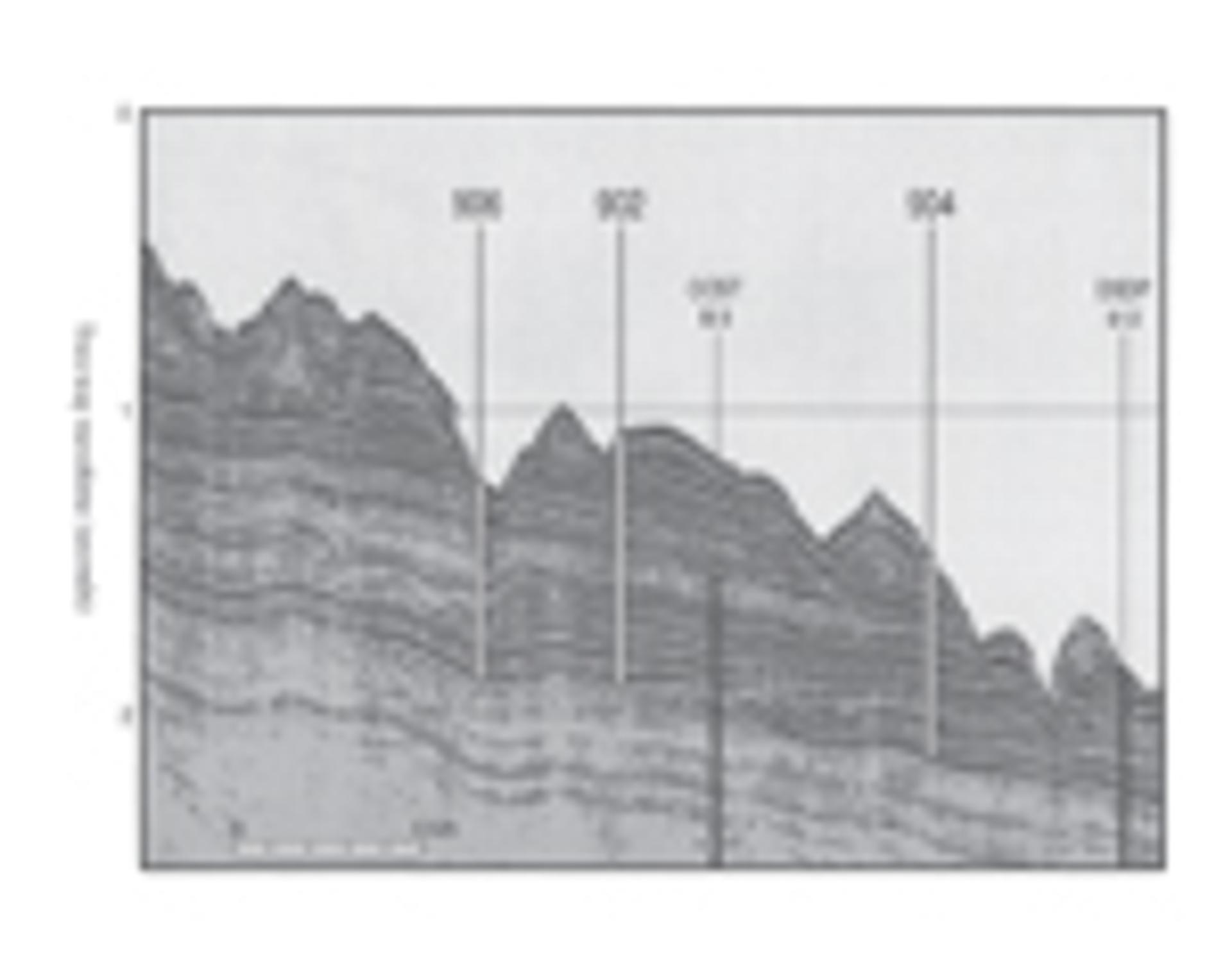
Multichannel Seismic Line 1027 in Baltimore Canyon, used to locate the best sites (902, 904, and 906) during Ocean Drilling Program Leg 150 (Mountain et al., 1994). Cored intervals are shown in white. Also shown are the locations of Deep Sea Drilling Project Site 612 (Leg 95) and the Continental Offshore Stratigraphic Test (COST) B-3 well. The COST B3 well was used to establish first-order age and facies successions. These sediments were cored to establish a history of sea-level variations along the mid-Atlantic U.S. continental margin. Mission-specific drilling platform Expedition 313 continued the coring in modern water depths of 30–35 m and recovered nearshore and onshore sediments deposited during Neogene changes in global sea level.
Seven days later, Leg 2 began coring across the Atlantic. The scientific party of eight included two female micropaleoentologists, Catherine Nigrini (SIO) and Maria Bianca Cita (Instituto di Geologia, Universitá di Milano, Italy). This began a tradition of international participation that was formalized in 1975: five countries (Federal Republic of Germany, France, Japan, the Soviet Union, and the UK) became contributing international partners in the International Phase of Ocean Drilling (IPOD). Today, 23 countries are part of the IODP consortium, and women comprise about half of the science team.
Technological development continually improved drilling, coring, and logging. In 1970, the first re-entry cone was deployed (Leg 15, Site 146, Venezuelan Basin), allowing the drill string to be pulled, a new bit attached, and coring in the same hole to continue. This enabled the drilling of deep holes through sediment and into hard rock. In 1979 (Leg 64, Guymas Basin), the hydraulic piston core (HPC) was deployed for the first time (Fig. S2 [see footnote 1]). Today, the HPC and multiple offset holes at a single site are routine for paleoceanographic expeditions. This allows construction of complete “composite” stratigraphic records, essential for detailed paleoceanographic research (Figs. 2 and S3–S5 [see footnote 1]).
Figure 2
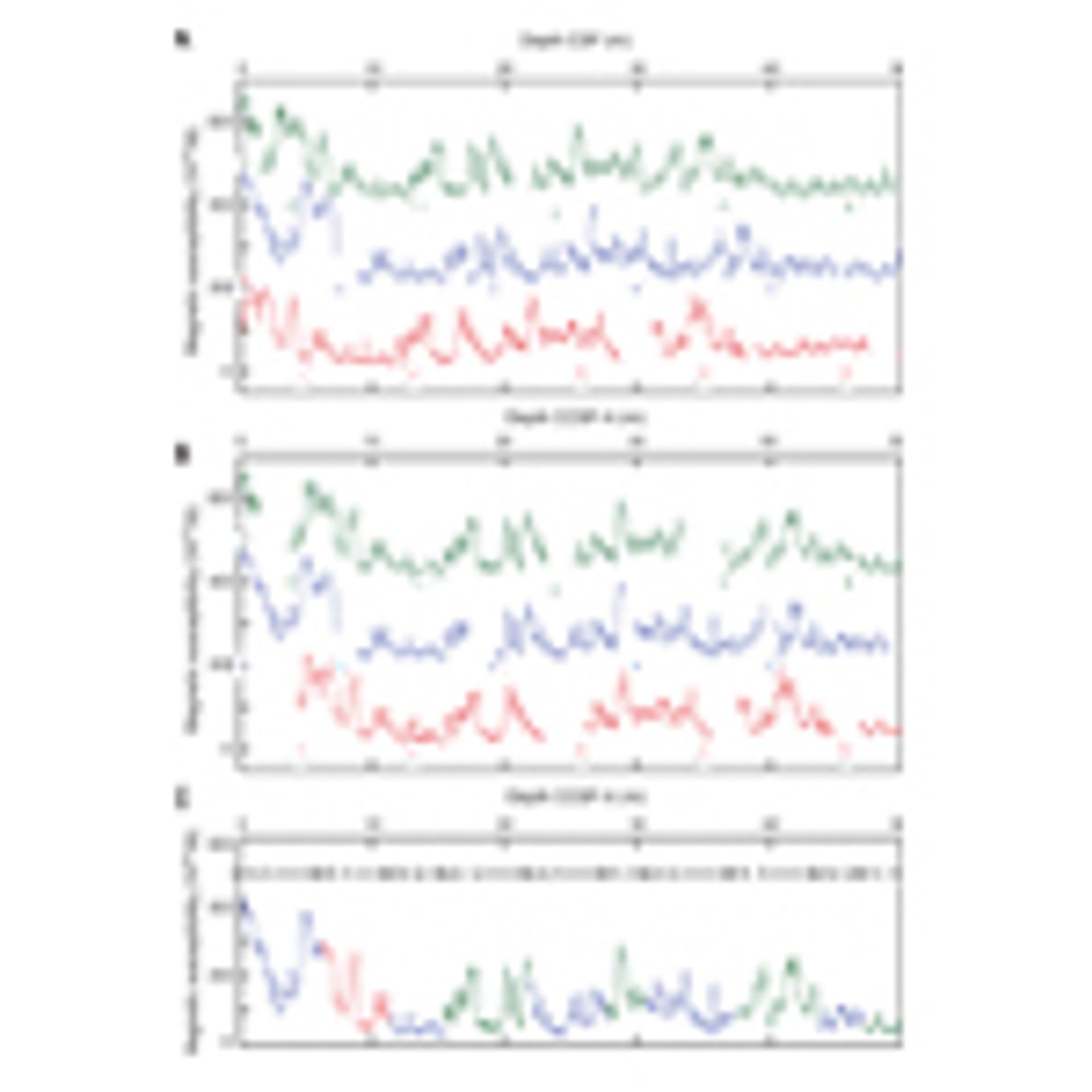
The tops and bottoms of cores are usually disturbed and there are often coring gaps between cores. To remedy this and create a complete stratigraphic sequence, a “composite” ideal core is created by splicing together data from different holes to so that coring gaps in one hole are filled with core intervals from an adjacent hole, trying not to use the tops and bottoms of cores. To generate a composite core depth below seafloor (CCSF-A) at least two or more holes are drilled at each site and each hole is slightly offset by depth from the other (Fig. S3 [see text footnote 1]). Hole core measurements, such as magnetic susceptibility and natural gamma ray, and/or split core images and lithologic changes from the different holes are aligned using distinguishing features, such as a sharp peak or a color change. (See Figs. S3–S5 for additional examples.) (A) Example from Site U1333, central Pacific, showing construction of a CCSF-A. In this example, magnetic susceptibility measurements from different holes are aligned by depth; Hole U1333A (red), Hole U1333B (blue), Hole U1333C (green). Numbers indicate the order of cores taken in the hole. (B) Depth-shifted cores on composite depth scale (CCSF-A [m]) aligning distinguishing features. (C) The magnetic susceptibility records the different holes that are part of the splice are shown by the hole color along the bottom. Along the top, core breaks (triangles) and hole designations are shown (from Pälike et al., 2010).
The JOIDES Resolution
Ocean Drilling Program (ODP, 1983–2003)
By the late 1970s, JOIDES began exploring alternative vessels. Major improvements in heave compensation and station-keeping ability offered better cores and an expansion of geographic areas that could be explored. More research could be accomplished with expanded laboratories and more scientists. The SEDCO/BP 471, an oil exploration vessel, was chosen, highlighting the advances in technology generated by the petroleum industry. Funding for the new program came from the United States and member countries. Texas A&M University was awarded the contract. The SEDCO/BP 471 was converted to a scientific drilling vessel, the JOIDES Resolution, and on 11 January 1985 commenced operations. Unlike petroleum exploration, which relies heavily on well logs and cuttings to understand the geology of a location, SOD collects cores. For most JOIDES Resolution legs, a shipboard scientific party would analyze cores and document findings during two-month expeditions, working in two 12-hour shifts, seven days a week.
Integrated Ocean Drilling Program (IODP, 2003–2013)
Despite the capabilities of the JOIDES Resolution, critical locations remained inaccessible. Without a riser system, with its casing and the ability to circulate mud and prevent blowouts, many thickly sedimented continental margins and subduction zones were out of reach. Locations at some high latitudes with ice and in very shallow water could not be explored. To meet these scientific needs, a new era of SOD began in October 2003. The riser-equipped, Japanese-built Chikyu, capable of drilling deep into heavily sedimented margins, and the mission-specific drilling platforms (MSPs) operated though the European Consortium for Ocean Research Drilling were added.
International Ocean Discovery Program (IODP, 2013–2023)
Today, there is a much broader understanding of the interconnections among Earth’s spheres, and new fields of research have developed. Much has been learned about how Earth operates. But, the details necessary to reach the next level of understanding require interdisciplinary expertise, atmospheric scientists, computer modelers, and biologists. Achieving deeper knowledge has become more complex and requires a new approach. This broadly integrated approach is laid out in the present science plan: Illuminating Earth’s Past, Present, and Future (IODP, 2011).
Some SOD Highlights
SOD has been an engine for understanding Earth processes. Tens of thousands of papers have been published, some among the most highly cited in Earth science. Thousands of scientists from around the world, from undergraduates to emeritus, have been involved in the research, forming international collaborations extending beyond SOD.
Describing the results in a short paper is challenging and necessarily incomplete. Here, three areas where SOD contributed to major revolutions in our understanding of Earth are described: plate tectonics, paleoceanography, and the deep marine biosphere. These topics are intertwined. Clearly, plate tectonics impacts ocean and climate history, which in turn affects the deep biosphere; all are connected through carbon and water cycling. Future drilling will continue to enhance geoscientists’ understanding of interconnected Earth processes from both a planetary and a human impact perspective.
Revolution #1: Plate Tectonics
In the ocean, plate tectonic knowledge has come from geophysical studies, submersible observations, and samples, drill cores, and instrumented boreholes to monitor in situ processes. As information leading to the wide acceptance of plate tectonics accumulated, one of the most convincing data sets came from DSDP Leg 3. “The most interesting finding from the paleontological studies is the correlation of paleontologic ages of sediments immediately overlying the basalt basement with ages of basement predicted by the sea-floor spreading hypothesis” (Maxwell et al., 1970, p. 445).
Below, briefly summarized, are some of the major results learned since Leg 3.
Rifted Margins (Also Called Passive Margins)
Continental rifting and ocean basin formation are central processes of plate tectonics and continue to be an important focus of SOD. This is an iterative process, with geophysical surveys identifying prime drilling targets and SOD providing the cores to determine the age and composition of specific reflectors. Primary influences on rift development are related to mantle composition, thermal structure, and tectonic stresses. This results in two end-member classifications, magma-rich and magma-poor (non-volcanic) margins.
Magma-rich margins were drilled during multiple expeditions (Legs 38, 81, 104, 152, 163) with segments along the East Greenland–Norwegian rifted margins (Fig. S6 [see footnote 1]), an area that constitutes part of the North Atlantic Igneous Province. An early surprise in drilling these margins was that some of the well-defined, seaward-dipping reflectors west of Norway consisted of subaerial extrusive basalts. Later, 40Ar-39Ar dating of volcanic rocks in southeast Greenland showed that the breakup evolution spanned ~12 m.y. (Tegner and Duncan, 1999).
Magma-poor margin drilling has taken place on the once contiguous Newfound-land-Iberian margins (Legs 47, 149, and 173, and Expedition 210), and in the South China Sea (Expeditions 349, 367, and 368). These expeditions, with sites carefully located along seismic lines, have recovered sediments, continental crust, a wide variety of igneous rocks, and even serpentinized mantle. Most recently, MSP Expedition 381 cored the Corinth Rift in the Mediterranean. There, a syn-rift sequence is accessible, allowing the fault and rift evolutionary history, including the deformation rates, to be determined.
Ocean Crust and Lithosphere
Understanding the composition and structure of ocean crust, how it varies, and how it is accreted is fundamental to understanding Earth’s basic evolution. In the late 1970s, the structure of ocean crust gleaned from geophysical surveys, dredge hauls, submersible observations, and ophiolites was perceived as fairly simple: basalts on the seafloor were fed by sheeted dike complexes that emanated from a magma chamber where gabbro crystalized and accumulated over underlying mantle. There was, as there is today, discussion about the differences between fast and slow spreading and the distinguishing features of backarc basins. Now parts of the ocean crust have been sampled, boreholes instrumented, and geophysical and submersible observations collected. The ocean floor is much more varied and complex than the early models suggested.
Multiple expeditions at Hole 504B (Alt et al., 1996) and Hole 1256D (Wilson et al., 2006) in the eastern Pacific partially support the model of layered ocean crust, with basalts overlying sheeted dikes, which in their deeper parts contain lenses of gabbro. The structure and composition of the deeper crustal components was addressed at the Hess Deep Rift on the East Pacific Rise (Leg 147 and Expedition 345). There, the variety of textures and composition of the plutonic rocks was larger than expected.
In the Atlantic, where spreading is slower, investigators were initially surprised by the presence of serpentine mixed with basalts (Site 395, Leg 45). Many subsequent expeditions showed that mantle and lower crustal rocks, displaced upward along major normal faults, are integral components of slow and ultra-slow spreading crust. These faults are also conduits for hydrothermal fluids that lead to the formation of massive sulfide deposits as observed in the Trans-Atlantic Geo-traverse hydrothermal field (Leg 158).
A critical component of modeling crustal accretion (and subduction) is understanding the role of hydrothermal circulation. To learn more about this plumbing system, many holes have been instrumented with circulation obviation retrofit kits (CORKs). CORKs seal off the borehole from the sea floor, allowing in situ measurements of pressure and temperature, and show the extent of fluid circulation in young ocean crust, which may be one of the most hydrologically active formations on Earth (Becker and Fisher, 2000). Advanced CORKs allow for additional measurements (e.g., seismometers and fluid sampling), ocean observatories, and experiments (Fisher et al., 2011; Figs. 3 and S7 [see footnote 1]).
Figure 3
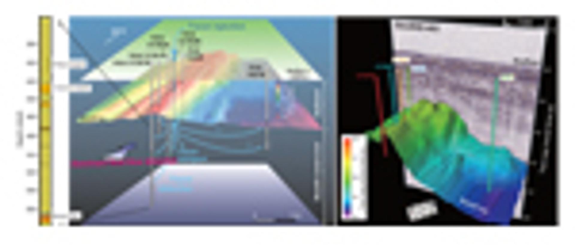
Schematic (not to scale) of borehole locations and experimental design for a tracer injection experiment conducted during and after Expedition 327 to investigate transport rates in the upper ocean crust. Boreholes observatories were placed in ~3.5–3.6-m.y.-old crust on the eastern flank of the Juan de Fuca Ridge. Thicker sections of the drill pipe indicate open intervals where tracer was injected or sampled. The stratigraphy of the upper volcanic crust at Hole U1301B is shown on the left. Main diagram modified from Fisher et al. (2011), and stratigraphic column is from Becker et al. (2013). Experimental results indicate very rapid tracer transport (meters/day), with most of the flow occurring in a small fraction of the rock (Neira et al., 2016). See Figure S7 for additional information (see text footnote 1).
Convergent Boundaries
Convergent boundaries (subduction zones) include island arcs, forearcs, backarc basins, and accretionary prisms. Processes at these plate boundaries are more likely to impact humans than any other component of plate tectonics, generating large earthquakes, explosive volcanoes, and tsunamis. The Chikyu has focused on the deeper portions of this plate boundary, especially in the Nankai Trough and Japan Trench.
Drilling has been essential in illuminating the origin and evolution of convergent margins. Not only are crust and sediment being subducted, but material from the overlying plate is scraped off by the underlying plate, termed subduction erosion. This process is ubiquitous at convergent margins, recycling material deep into the lower crust and mantle (e.g., Scholl and von Huene, 2009). Trace elements and isotopic tracers in volcanic rocks substantiate the subduction and hence chemical recycling of ocean sediments (e.g., Plank and Langmuir, 1993).
Crucial to the processes at subduction margins is illuminating the cause of large earthquakes, identifying what happens at the seismogenic zone when the release of pressure causes a major rupture. From cores and borehole measurements, variations in lithologies, fluids, pore pressure, and heat flow have been documented. These observations, in conjunction with dip angle, subducting seafloor topography, and results from ocean bottom seismometers, highlight this environment’s complexity.
Multiple Legs (DSDP, ODP) and Expeditions (IODP) have focused on subduction zones and backarc basins. The Nankai Trough Seismogenic Zone Experiment (NanTroSEIZE) on board the Chikyu is a multiyear project to core through a plate boundary in an active fault area. In addition to cores, it is providing the opportunity to monitor hydrologic and geodynamic properties of the subduction zone through borehole observatories. All of this information will help to develop models that describe subduction zone process and should allow geoscientists to better explain and predict earthquake behavior and tsunami generation.
Revolution #2: Climate and Ocean Change: Paleoceanography
The science of pre-Quaternary paleo-ceanography arguably did not exist when the Glomar Challenger set sail in 1968. The first International Congress of Paleoceanography took place in Zurich, Switzerland, in 1983, and the American Geophysical Union began publishing Paleoceanography (now Paleoceanography and Paleoclimatology) in 1986. Early paleoceanographic research, based on short cores, showed a marine expression of the Ice Ages recognized on land. Oxygen isotope records of foraminifera (Emiliani, 1957) documented more than the four previously identified Ice Ages and hinted at a cyclicity later tied to orbital forcing. Longer cores were needed to extend these records. Today, compilations of oxygen (δ18O) and carbon isotope values (δ13C) from calcite secreted by benthic foraminifera are essential for past climate reconstructions. Data compiled by Zachos et al. (2001), Lisiecki and Raymo (2005), and Cramer et al. (2009), include tens of thousands of analyses from hundreds of cores collected by many scientists over decades. These compilations and many new oceanographic proxies document long- and short-term climate change and rates of change. But the changes go far beyond “just” climate. SOD has allowed us to identify changes in ocean chemistry, better understand the effect of the asteroid impact at the K/Pg boundary, and, through continuous ocean records, better understand evolution.
All of these advances benefit from excellent resolution, provided by continuing developments in paleomagnetics, biostratigraphy, X-ray core scanners, and orbitally tuned age models. Early in SOD, holes were often spot cored. Then the community decided that holes generally should be continuously cored. After the advent of the HPC, higher resolution work became possible, but cores in a single hole do not provide a truly complete record. The top and bottom of each core is disturbed. Today, multiple, overlapping holes at a single site allow creation of a continuous composite core (Fig. 2). Here, highlights of two paleoceanographic achievements are briefly summarized.
Messinian Salinity Crisis
Leg 13 departed Lisbon, Portugal, in 1973 to explore the origins of the Mediterranean Sea and, in particular, to identify reflectors on seismic profiles. Coring the pervasive and prominent M-Reflector proved problematic. The problem was caused by the unexpected presence of gravel, which jammed the drill pipe, and salt (dolomite, gypsum, anhydrite, and halite), which was slow to impossible to penetrate. The M-reflector was caused by the top of a thick salt layer that accumulated in the late Miocene, 3 km below the surface of the Atlantic Ocean. The initial interpretation was that the Mediterranean dried up several times during the Messinian (Hsü et al., 1973). The details about the causes and extent of the desiccation and the role of tectonics have been debated ever since (Ryan, 2009). Additional drilling in the Mediterranean, with better coring capabilities and refinement of the areas to be drilled, is needed. Among the new IODP proposals is “The Demise of a Salt Giant,” to examine the climate and environmental transitions during the terminal Messinian salinity crisis.
Paleocene–Eocene Thermal Maximum (PETM)
At the start of the ODP, no one knew about the PETM. This global warming event challenges our understanding of the carbon cycle and is discussed in more than 500 refereed papers. Its discovery led to identification of multiple “hyperthermal events” of lesser magnitude in the Paleocene–Eocene, thus a new view of climate instability in a greenhouse world. First identified in Site 690 (Leg 113, Weddell Sea, Antarctica), it was characterized by extinction of benthic foraminifera (Thomas, 1989). Stable isotope data told an incredible story, a rapid deep-sea warming combined with a massive negative carbon isotope excursion (Kennett and Stott, 1991) and—as later recognized—widespread deep-sea carbonate dissolution due to ocean acidification (Zachos et al., 2005). The details of this event are still debated, but the deep ocean warmed ~5–8 °C in a few tens of thousands of years, ca. 55.8 Ma (Mudelsee et al., 2014). Even in the Arctic Ocean, already ~18 °C, temperatures rose an additional 5–6 °C during the PETM (Sluijs et al., 2006).
Acidification and a δ13C excursion were linked to a massive discharge of carbon. Calculating how much carbon was released depends upon the source and its isotopic composition. This has been highly debated and may be some combination of decomposing clathrates (Dickens et al., 1995), burning of organic matter (Kurtz et al., 2003), mantle-sourced volcanic CO2, and interaction of magma with organic matter (Svensen et al., 2004; Gutjahr et al., 2017).
Revolution #3: Biosphere Frontiers: Deep Marine Biosphere
From its initiation, there have been serendipitous discoveries by SOD, but probably none was as unexpected as that of the deep biosphere. In the late 1980s, some researchers began to discover microbial activity in deep marine sediments (e.g., Whelan and Tarafa, 1986). This discovery didn’t get celebrated the same way as the discovery of the hydrothermal vent communities a decade earlier. Yet these communities, invisible to the naked eye, contain abundant biomass. Just how much is a matter of debate; Kallmeyer et al. (2012) estimated there are roughly as many cells in marine sediment as in the ocean or in soil. Bar-On et al. (2018) refined the estimate to 77 Gt of carbon (~14% of biomass carbon) that reside in the deep subsurface, both land and marine.
Are they living cells? Metabolic rates of these communities are orders of magnitude slower than those on the surface and hence barely detectable (e.g., D’Hondt et al., 2002; Hoehler and Jørgensen, 2013). Unknown and critical to this discussion is determining the connections between the geobiosphere that humans inhabit and this barely explored marine world.
The accomplishments that have been made did not come easily. Even after samples are collected, there are challenges, such as characterizing bacteria that grow so slowly as to be virtually dormant. Despite the challenges, there is now access to this new world (Inagaki et al., 2015). Maybe fifty years from now geoscientists will be shocked at our ignorance about such a critical component of Earth processes.
Gas hydrates are also part of deep biosphere research. Several decades ago, they were inferred from bottom simulating reflectors (BSRs), a puzzling reflector that corresponded with the predicted base of the methane hydrate stability zone. First cored on Leg 67, sediment above the BSR indeed contained hydrates, and as the cores warmed and the gas expanded, the sediment left the core barrel and shot across the deck. Special pressure core barrels needed to be and were developed. Now scientists on the JOIDES Resolution have cored gas hydrates in many environments, especially on subduction margins. For example, scientists on Expedition 311 (Cascadia Margin) determined that most of the marine hydrate is caused by the microbial reduction of CO2 within the hydrate stability zone (Riedel et al., 2010). Looking to the future, dissociation of hydrates might produce slope instability and the release of methane.
Present (2013–2023)
Illuminating Earth’s Past, Present and Future (IODP, 2011) describes four themes of focus for the current IODP. It highlights opportunities to use SOD to explore connections between Earth’s spheres in ways that will help to further revolutionize geoscience. Each theme is briefly described in the following sections.
Planetary Dynamics (Deep Processes and Their Impact on the Earth’s Surface Environment)
Plate tectonics is the driving force for Earth processes. Yet, despite decades of research, some of the most basic mechanisms are not fully understood. What is clear is that the seemingly different components of the Earth system are connected, and water and carbon are primary connectors. To understand these processes, geoscientists need samples from the surface sediment, through the ocean crust to the mantle. Although plate tectonics appears to be a fairly steady-state process today, it may not always have been so. For example, there is much to learn about the past emplacement of large igneous provinces, when massive amounts of mafic magma were discharged into the ocean and onto land, and abundant gases (CO2, H2S, and SO2) were emitted into the atmosphere.
Climate and Ocean Change: Reading the Past, Informing the Future
The ocean ecosystem is changing in response to elevated atmospheric CO2: it is becoming warmer, and the ocean is acidifying. The rate of modern changes may be unprecedented (except for asteroid impacts), but Earth has experienced similar perturbations in the past. The carbonate compensation depth has risen and fallen, and icebergs left rocky trails of their passage. Through examination of marine sediment cores, geoscientists can determine how the ocean (and ocean life) responded in the past. Collecting the detailed data necessary to better characterize past changes will help climate modelers better predict our future.
Biosphere Frontiers: Deep Life, Biodiversity, and Environmental Forcing of Ecosystems
The unexpected finding of microbial communities in the sea floor opens a wide variety of possibilities for exploration. Their very existence challenges our understanding of the minimal conditions necessary for life. Three major themes are being addressed: (1) sub-seafloor microbial communities; (2) the limits to life in the deep biosphere; and (3) community adaptation to a changing environment. This information will increase understanding of biodiversity and evolutionary paths on Earth and aid expectations for the existence of life in other parts of the solar system.
Earth in Motion (Geohazards)
An increasing human population, especially in coastal areas, puts more people in harm’s way. This harm can come rapidly from earthquakes, tsunamis, volcanoes, and landslides. This is an area where borehole tools have a crucial role in furthering our understanding of the subsurface processes that cause these changes. Long-term, in situ data collection can monitor the conditions of earthquake generation and biogeochemical cycling, allowing the rate of the different components of these changes to be better understood and providing the data for more accurate modeling of these critical environments.
Future (Post-2023)
Plans for the science program for the next phase of SOD are already under way as many critical questions remain. For example: How do subduction zones initiate and continents rift? How fast can sea level rise? How have marine microbial communities responded to past changes in ocean chemistry and temperature? This is an opportunity for geoscientists from many disciplines and countries to become involved in the continuation of an exciting international program that is critical to Earth science.
Conclusions
Although we have yet to drill through the Mohorovicic Discontinuity, SOD has radically changed and continues to change our view of Earth. Early SOD showed an unexpectedly young ocean and confirmed plate tectonics as the underlying mechanism for Earth processes. Recent SOD provides new information about elemental recycling and Earth history. Just as we learn more about outer space and the origin of the universe with better telescopes and planetary missions, we will learn more about our planet, the processes that drive it, and the origin of life as drilling technology improves. The intrigue continues as each seismic survey defines where to drill, each core sheds new light on Earth’s past and helps predict its future, and borehole instrumentation provides in situ monitoring of Earth’s processes.
Acknowledgments
This article was considerably improved thanks to discussions with and reviews from B. Clement, S. D’Hondt, A. Fisher, J. Karson, J. McManus, E. Thomas, B. Tucholke, D. Royer, GSA Today editor G. Dickens, and two anonymous reviewers. Please share your favorite highlights of SOD in the GSA Member Community Open Forum at https://bit.ly/2KhR493.
References2
- Alt, J., Laverne, C., Vanko, D.A., Tartarotti, P., Teagle, D.A.H., Bach, W., Zuleger, E., Erzinger, J., Honnorez, J., Pezard, P.A., Becker, K., Salisbury, M.H., and Wilkens, R.H., 1996, Hydrothermal alteration of a section of upper oceanic crust in the eastern equatorial Pacific: A synthesis of results from Site 504 (DSDP Legs 69, 70, and 83, and ODP Legs 111, 137, 140, and 148), in Alt, J. C., Kinoshita, H., Stokking, L.B., and Michael, P.J., eds., Proceedings of the Ocean Drilling Program, Scientific Results, v. 148: College Station, Texas A&M University, https://doi.org/10.2973/ odp.proc.sr.148.159.1996.
- Bar-On, Y.M., Phillips, R., and Milo, R., 2018, The biomass distribution on Earth: Proceedings of the National Academy of Sciences, v. 115, p. 6506–6511, https://doi.org/10.1073/pnas.1711842115.
- Bascom, W., 1961, A Hole in the Bottom of the Sea; The Story of the Mohole Project: Garden City, N.Y., Doubleday, 352 p.
- Becker, K., and Fisher, A.T., 2000, Permeability of upper oceanic basement on the eastern flank of the Endeavor Ridge determined with drillstring packer experiments: Journal of Geophysical Research, v. 105, p. 897–912.
- Becker, K., Fisher, A.T., and Tsuji, T., 2013, New packer experiments and borehole logs in upper oceanic crust: Evidence for ridge-parallel consistency in crustal hydrogeologic properties: Geochemistry Geophysics Geosystems, v. 14, https://doi.org/10.1002/ggge.20201.
- Cramer, B.S., Toggweiler, J.R., Wright, J.D., Katz, M.E., and Miller, K.G., 2009, Ocean overturning since the Late Cretaceous: Inferences from a new benthic foraminiferal isotope compilation: Paleoceanography, v. 24, https://doi.org/10.1029/2008PA001683.
- D’Hondt, S., Rutherford, S., and Spivack, A.J., 2002, Metabolic activity of subsurface life in deep-sea sediments: Science, v. 295, p. 2067–2070, https://doi.org/10.1126/science.1064878.
- Dickens, G.R., O’Neil, J.R., Rea, D.K., and Owen, R.M., 1995, Dissociation of oceanic methane hydrate as a cause of the carbon-isotope excursion at the end of the Paleocene: Paleoceanography, v. 10, p. 965–971, https://doi.org/10.1029/95PA02087.
- Emiliani, C., 1957, Temperature and age analysis of deep-sea cores: Science, v. 125, p. 383–387, https://doi.org/10.1126/science.125.3244.383.
- Fisher, A.T., Cowen, J., Wheat, C.G., and Clark, J.F., 2011, Preparation and injection of fluid tracers during IODP Expedition 327, eastern flank of Juan de Fuca Ridge, in Fisher, A.T, Tsuji, T., Petronotis, K., and the Expedition 327 Scientists, Proceedings of the Integrated Ocean Drilling Program, v. 327: Tokyo, Integrated Ocean Drilling Program Management International, Inc., https://doi.org/ 10.2204/iodp.proc.327.108.2011.
- Gray, G.W., 1956, The Lamont Geological Observatory: Scientific American v. 195, p. 83–94, https://doi.org/10.1038/scientific american1256-83.
- Gutjahr, M., Ridgwell, A., Sexton, P.F., Anagnostou, E., Pearson, P.N., Palike, H., Norris, R.D., Thomas, E., and Foster, G.L., 2017, Very large release of mostly volcanic carbon during the Palaeocene–Eocene Thermal Maximum: Nature, v. 548, p. 573–577.
- Hess, H.H., 1962, History of ocean basins, in Engel, A.E.J., James, H.L., and Leonard, B.F., eds., Petrologic Studies: A Volume in Honor of A.F. Buddington: New York, Geological Society of America, p. 599–620.
- Hoehler, T.M., and Jørgensen, B.B., 2013, Microbial life under extreme energy limitation: Nature Reviews, Microbiology, v. 11, p. 83–94, https://doi.org/10.1038/nrmicro2939.
- Hsü, K., 1992, Challenger at Sea: A Ship That Revolutionized Earth Science: Princeton, New Jersey, Princeton University Press, 464 p., https://doi.org/10.1515/9781400863020.
- Hsü, K.J., Ryan, W.B.F., and Cita, M.B., 1973, Late Miocene desiccation of the Mediterranean: Nature, v. 242, p. 240–244, https://doi.org/ 10.1038/242240a0.
- Inagaki, H., et al., 2015, Exploring deep microbial life in coal-bearing sediment down to ~2.5 km below the ocean floor: Science, v. 349, p. 420–424, https://doi.org/10.1126/ science.aaa6882.
- IODP (International Ocean Discovery Program), 2011, Illuminating Earth’s Past, Present, and Future: http://www.iodp.org/about-iodp/iodp-science-plan-2013-2023 (accessed 14 Dec. 2018).
- Isacks, B., Oliver, J., and Sykes, L., 1968, Seismology and the new global tectonics: Journal of Geophysical Research, v. 73, p. 5855–5899, https://doi.org/10.1029/JB073i018p05855.
- Kallmeyer, J., Pockalny, R., Adhikari, R.R., Smith, D.C., and D’Hondt, S., 2012, Global distribution of microbial abundance and biomass in subseafloor sediment: Proceedings of the National Academy of Sciences, v. 109, 16,213–16,216, https://doi.org/10.1073/pnas.1203849109.
- Kennett, J.P., and Stott, L., 1991, Abrupt deep-sea warming, palaeoceanographic changes and benthic extinctions at the end of the Palaeocene: Nature, v. 353, p. 225–229, https://doi.org/10.1038/353225a0.
- Koppers, A.A.P., Escutia, C., Inagaki, F., Palike, H., Saffer, D., and Thomas, D., 2019, Scientific ocean drilling: Looking to the future: Oceanography, v. 32 (in press).
- Kurtz, A.C., Kump, L.R., Arthur, M.A., Zachos, J.C., and Paytan, A., 2003, Early Cenozoic decoupling of the global carbon and sulfur cycles: Paleoceanography, v. 18, p. 14-1–14-14, https://doi.org/10.1029/2003PA000908.
- Lisiecki, L.E., and Raymo, M.E., 2005, A Pliocene–Pleistocene stack of 57 globally distributed benthic δ18O records: Paleoceanography, v. 20, p. 1–17.
- Maxwell, A.E., Von Herzen, R., and Shipboard Scientists, 1970, Initial Reports of the Deep Sea Drilling Project, v. 3: Washington, D.C., U.S. Government Printing Office.
- Mountain, G.S., Miller, K.G., Blum, P., et al., 1994, Proceedings of the Ocean Drilling Project, Initial Reports, v. 150: College Station, Texas, Texas A&M University.
- Mudelsee, M., Bickert, T., Lear, C.H., and Lohmann, G., 2014, Cenozoic climate changes: A review based on time series analysis of marine benthic δ18O records: Reviews of Geophysics, v. 52, p. 333–374, https://doi.org/10.1002/2013RG000440.
- National Research Council, 2011, Scientific Ocean Drilling: Accomplishments and Challenges: Washington, D.C., The National Academies Press, 146 p.
- Neira, N.M., Clark, J.F., Fisher, A.T., Wheat, C.G., Haymon, R.M., and Becker, K., 2016, Cross-hole tracer experiment reveals rapid fluid flow in the upper ocean crust: Earth and Planetary Science Letters, v. 450, p. 355–365, https://doi.org/10.1016/j.epsl.2016.06.048.
- Pälike, H., Lyle, M., Nishi, H., Raffi, I., Gamage, K., Klaus, A., and the Expedition 320/321 Scientists, 2010, Pacific Equatorial Age Transect, Proceedings of the Integrated Ocean Drilling Program, v. 320–321: Tokyo, IODP Management International, Inc., https://doi.org/10.2204/iodp.proc .320321.2010.
- Pitman, W.C., Herron, E.M., and Heirtzler, J.R., 1968, Magnetic anomalies in the Pacific and sea floor spreading: Journal of Geophysical Research, v. 73, p. 2069–2085, https://doi.org/ 10.1029/JB073i006p02069.
- Plank, T., and Langmuir, C., 1993, Tracing trace elements from sediment input to volcanic output at subduction zones: Nature, v. 362, p. 739–743, https://doi.org/10.1038/362739a0.
- Riedel, M., Collett, T.S., and Malone, M., 2010, Expedition 311 synthesis: Scientific findings: Proceedings of the Integrated Ocean Drilling Program, v. 311: Integrated ODP Management International, Inc., https://doi.org/ 10.2204/iodp.proc.311.213.2010.
- Ryan, W.B.F., 2009, Decoding the Mediterranean salinity crisis: Sedimentology, v. 56, no. 1, p. 95–136, https://doi.org/10.1111/j.1365-3091 .2008.01031.x.
- Scholl, D.W., and von Huene, R., 2009, Implications of estimated magmatic additions and recycling losses at the subduction zones of accretionary (non-collisional) and collisional (suturing) orogens: Earth Accretionary Systems in Space and Time, v. 318, p. 105–125.
- Sluijs, A, Shouten, S., and Expedition 302 Scientists, 2006, Subtropical Arctic Ocean temperatures during the Palaeocene/Eocene thermal maximum: Nature, v. 441, p. 610–613, https://doi.org/10.1038/nature04668.
- Stein, R., Blackman, D.K., Inagaki, H., and Larsen, H.-C., editors, 2014, Earth and Life Processes Discovered from Subseafloor Environments: A Decade of Science Achieved by the Integrated Ocean Drilling Program (IODP), v. 7, Developments in Marine Geology: Amsterdam, Elsevier, 829 p.
- Storey, M., Duncan, R.A., and Tegner, C., 2007, Timing and duration of volcanism in the North Atlantic Igneous Province: Implications for geodynamics and links to the Iceland hotspot: Chemical Geology, v. 241, p. 264–281, https://doi.org/10.1016/j.chemgeo.2007.01.016.
- Svensen, H., Planke, S., Malthe-Sorenssen, A., Jamtveit, B., Myklebust, R., Eidem, T.R., and Rey, S.S., 2004, Release of methane from a volcanic basin as a mechanism for initial Eocene global warming: Nature, v. 429, p. 542–545, https://doi.org/10.1038/nature02566.
- Tegner, C., and Duncan, R.A., 1999, 40Ar-39Ar chronology for the volcanic history of the southeast Greenland rifted margin, v. 163: Proceedings of the Ocean Drilling Project, Scientific Results, p. 53–62, https://doi.org/ 10.2973/odp.proc.sr.163.108.1999.
- Thomas, E., 1989, Development of Cenozoic deep-sea benthic foraminiferal faunas in Antarctic waters, in Crame, J.A., ed., Origins and Evolution of the Antarctic Biota: An Introduction: London, Geological Society, p. 283–296.
- Vine, F.J., and Matthews, D.H., 1963, Magnetic anomalies over oceanic ridges: Nature, v. 199, p. 947–949, https://doi.org/10.1038/199947a0.
- Whelan, J., and Tarafa, M., 1986, Organic matter in Leg 96 sediments: Characterization by pyrolsis, in Bouma, A.H., Coleman, J.M., Meyer, A.W., et al., eds., Deep Sea Drilling Project Initial Reports, v. 96: Washington, D.C., U.S. Government Printing Office, p. 757–766, https://doi.org/10.2973/dsdp.proc.96.146.1986.
- Wilson, D.S., Teagle, D.A., Alt, J.C., and Shipboard Scientists, 2006, Drilling to gabbro in intact ocean crust: Science, v. 312, p. 1016–1020, https://doi.org/10.1126/science.1126090.
- Wilson, J.T., 1966, Did the Atlantic close and then re-open?: Nature, v. 211, p. 676–681, https://doi.org/10.1038/211676a0.
- Zachos, J.C., Pagani, M., Sloan, L., Thomas, E., and Billups, K., 2001, Trends, rhythms, and aberrations in global climate 65 Ma to present: Science, v. 292, p. 686–693, https://doi.org/ 10.1126/science.1059412.
- Zachos, J.C., Röhl, U., Schellenberg, S., Sluijs, A., Hodell, D., Thomas, E., Nicolo, M., Raffi, I., Lourens, L.J., McCarren, H., and Kroon, D., 2005, Rapid acidification of the ocean during the Paleocene–Eocene Thermal Maximum: Science, v. 308, p. 1611–1615, https://doi.org/10.1126/science.1109004.
-------
2 Here, unless there is a specific figure or quote from a scientific ocean drilling volume, references to initial discoveries from Legs (DSDP and ODP) and Expeditions (IODP) are given only by their Leg/Expedition number. Table S1 (see footnote 1) provides links to a complete listing of Legs and Expeditions.
