
Chicxulub and the Exploration of Large Peak-Ring Impact Craters through Scientific Drilling
David A. Kring et al.
In this article
Authors
David A. Kring
Lunar and Planetary Institute, Houston, Texas 77058, USA
Philippe Claeys
Analytical, Environmental and Geo-Chemistry, Vrije Universiteit Brussel, Pleinlaan 2, Brussels 1050, Belgium
Sean P.S. Gulick
Institute for Geophysics and Dept. of Geological Sciences, Jackson School of Geosciences, University of Texas at Austin, Austin, Texas 78758, USA
Joanna V. Morgan, Gareth S. Collins, and the IODP-ICDP Expedition 364 Science Party
Dept. of Earth Science and Engineering, Imperial College London SW7 2AZ, UK
Abstract
The Chicxulub crater is the only well-preserved peak-ring crater on Earth and linked, famously, to the K-T or K-Pg mass extinction event. For the first time, geologists have drilled into the peak ring of that crater in the International Ocean Discovery Program and International Continental Scientific Drilling Program (IODP-ICDP) Expedition 364. The Chicxulub impact event, the environmental calamity it produced, and the paleobiological consequences are among the most captivating topics being discussed in the geologic community. Here we focus attention on the geological processes that shaped the ~200-km-wide impact crater responsible for that discussion and the expedition’s first year results.
Manuscript received 3 July 2017; Revised manuscript received 26 July 2017; Manuscript accepted 28 July 2017; Published online 8 Sept. 2017
© The Geological Society of America, 2017.
Introduction
The Chicxulub crater (Hildebrand et al., 1991) on the Yucatán Peninsula of Mexico was produced by a terminal Cretaceous impact that has been linked to regional and global K-T or K-Pg boundary deposits (see reviews by Smit, 1999; Kring, 2000, 2007; Schulte et al., 2010). The subsurface structure was initially detected with geophysical techniques (Cornejo Toledo and Hernandez Osuna, 1950). While exploring the source of those anomalies, Petróleos Mexicanos (PEMEX) drilled three exploration wells (all dry) into the structure. Petrologic analyses of polymict breccias and melt rock in recovered core samples revealed shock-metamorphic and shock-melted features diagnostic of impact cratering (Kring et al., 1991; Kring and Boynton, 1992; Swisher et al., 1992, Sharpton et al., 1992; Claeys et al., 2003), proving the structure had an impact origin. The buried structure was confirmed by seismic surveys conducted in 1996 and 2005 to be a large ~180–200-km–diameter impact crater with an intact peak ring (Morgan et al., 1997; Gulick et al., 2008).
The discovery of the Chicxulub impact structure initially prompted two scientific drilling campaigns. In the mid-1990s, a series of shallow onshore wells up to 700 m deep were drilled by the Universidad Nacional Autónoma de México (UNAM; Urrutia-Fucugauchi et al., 1996) to sample near-surface impact breccias in the ejecta blanket surrounding the crater. In 2002, the International Continental Scientific Drilling Program (ICDP) also sponsored a deep drilling project, producing a 1511 m borehole between the peak ring and the crater rim. Continuous core beneath 404 m included Tertiary marine sediments, polymict impact breccias, an impact melt unit, and one or more blocks of Cretaceous sedimentary target rocks. We refer readers to two special issues of Meteoritics & Planetary Science (Jull, 2004a, 2004b) for the major results of that ICDP project, but note that the project left unresolved, among other things, the geologic processes that produced the peak-ring morphology of the crater.
The Chicxulub crater is the best-preserved peak-ring impact basin on Earth, so it is an essential target for additional study. The only other known similarly sized surviving impact structures, Sudbury and Vredefort, are tectonically deformed and eroded. Recently, the International Ocean Discovery Program (IODP) and ICDP drilled an offshore borehole into the crater (Fig. 1), recovering core from a depth of 505.7–1334.7 m below the sea floor (mbsf), to assess the depth of origin of the peak-ring rock types and determine how they were deformed during the crater-forming event. That information is needed to effectively test how peak-ring craters form on planetary bodies.
Figure 1
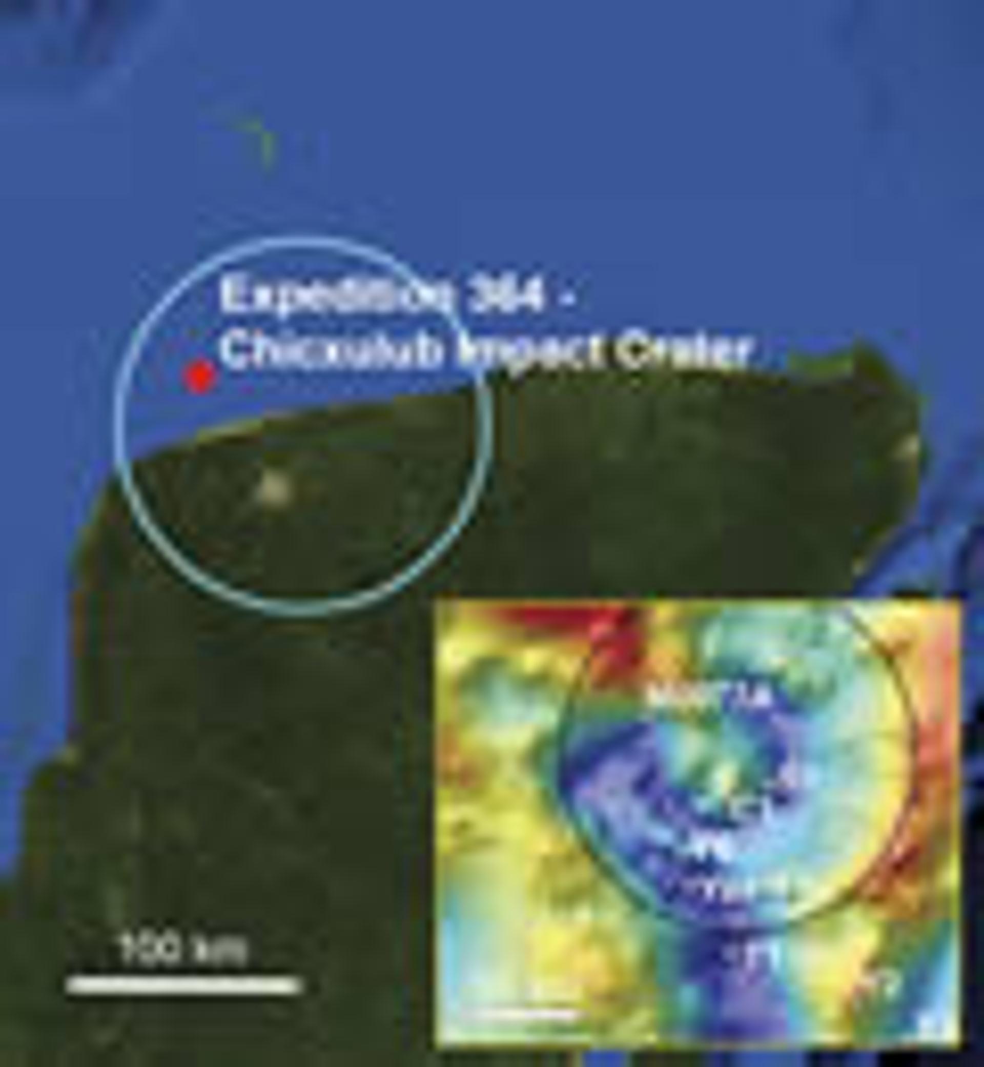
IODP-ICDP Expedition 364 drilled into the subsurface Chicxulub peak ring at borehole M0077A (red dot), which was ~30 km northwest of Progreso and the north shore of the Yucatán Peninsula. The blue circle represents the approximate diameter of the 180–200-km subsurface impact structure. The gravity signature of the structure (from lows of -16 to highs of +30 mgal) and locations of other drilling sites are shown in the inset. The only two sites with continuous core are the ICDP Yaxcopoil-1 (Yax-1) and IODP-ICDP M0077A boreholes. Other boreholes are Yucatán-1 (Y1), Yucatán-2 (Y2), Yucatán-6 (Y6), Chicxulub-1 (C1), Sacapuc-1 (S1), and Ticul-1 (T1).
The expedition was also designed to measure any hydrothermal alteration in the peak ring and physical properties of the rocks, such as porosity and permeability, to calibrate geophysical data, test models of impact-generated hydrothermal systems, evaluate the habitability of the peak ring, and investigate the recovery of life in a sterilized portion of Earth’s surface. The recovered rocks also make it possible to evaluate shock deformation of Earth’s crust, including the vaporization of rocks that may have contributed to climate-altering effects of the impact. A large number of geological, environmental, and biological results will emerge from the expedition. Here, we focus on the planetary geoscience findings: how the peak-ring crater formed and what peak-ring and multi-ring craters can reveal about deep planetary crusts. As the borehole pierced only a single location within the crater, we begin by looking at a fully exposed peak-ring crater on the Moon, which provides a picture of a similar structure to that targeted by Expedition 364.
Exposed Peak-Ring Craters
The Schrödinger basin near the south pole on the lunar far side is the youngest and best preserved peak-ring crater on the Moon (Fig. 2A). The ~320-km-diameter crater contains an ~150-km-diameter peak ring that rises up to 2.5 km above the crater floor (Shoemaker et al., 1994). The peak ring is topographically complex, with steep cliffs and open chasms. Summit heights vary along the circumference of the peak ring. On the Moon, where the erosional processes familiar on Earth do not occur, that differential topography is a primary feature, caused by shear and fault displacement during the emplacement of the peak ring (Kring et al., 2016).
Figure 2
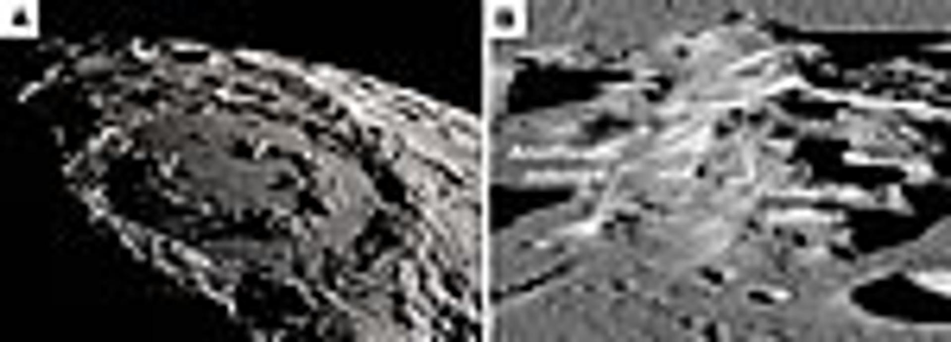
(A) The morphology of a peak ring is evident in this view of the ~320-km-diameter Schrödinger basin on the Moon, looking from the north toward the south pole. NASA’s Scientific Visualization Studio. (B) A close-up view of a segment of the peak ring with rocks uplifted from mid- to lower-crustal levels by the impact event. The field of view is ~17 km wide through the center of the image. Lunar Reconnaissance Orbiter Camera image M1192453566.
Spectral analyses of the lunar surface captured from the orbiting Chandraayan-1 spacecraft indicate the peak ring is composed of anorthositic, noritic, and olivine-bearing (e.g., troctolite or dunite) rocks from deep crustal or even upper mantle depths (Kramer et al., 2013). Those rock types occur in spectacular outcrops (Fig. 2B). Soon after Apollo, it was common to hear geologists lament that there are no outcrops on the Moon because the surface is covered with regolith. However, the rocks exposed in the peak ring constitute hectometer- to kilometer-size outcrops that are now recognized as high-priority sites for future lunar sample return missions (Potts et al., 2015; Steenstra et al., 2016).
Geologic mapping of those rock types and numerical modeling of peak-ring emplacement (Kring et al., 2016) suggest the rocks in the peak ring were derived from mid- to lower-crustal depths on the Moon (e.g., ~15–26 km deep). During the impact event, those rocks rose above the lunar surface and, without the strength to maintain that elevation, collapsed outward to form nappe-like structures in a circumferential peak-ring. Pre-impact crustal strength seems to have affected that process. A gap in the peak ring occurs in the southeastern quadrant, which is an area in the target that had been previously weakened by the Amundsen-Ganswindt basin-forming event. There, the peak ring collapsed below the level filled by impact melts and impact breccias. Pre-impact crustal thickness also varied across the target area, nearly doubling from 20 to 40 km from the east to the west and producing bilateral asymmetry in the peak ring (Fig. 3). As shown below, those types of morphological effects, visible at the surface on the Moon, are mirrored in the subsurface Chicxulub peak-ring basin on Earth.
Figure 3
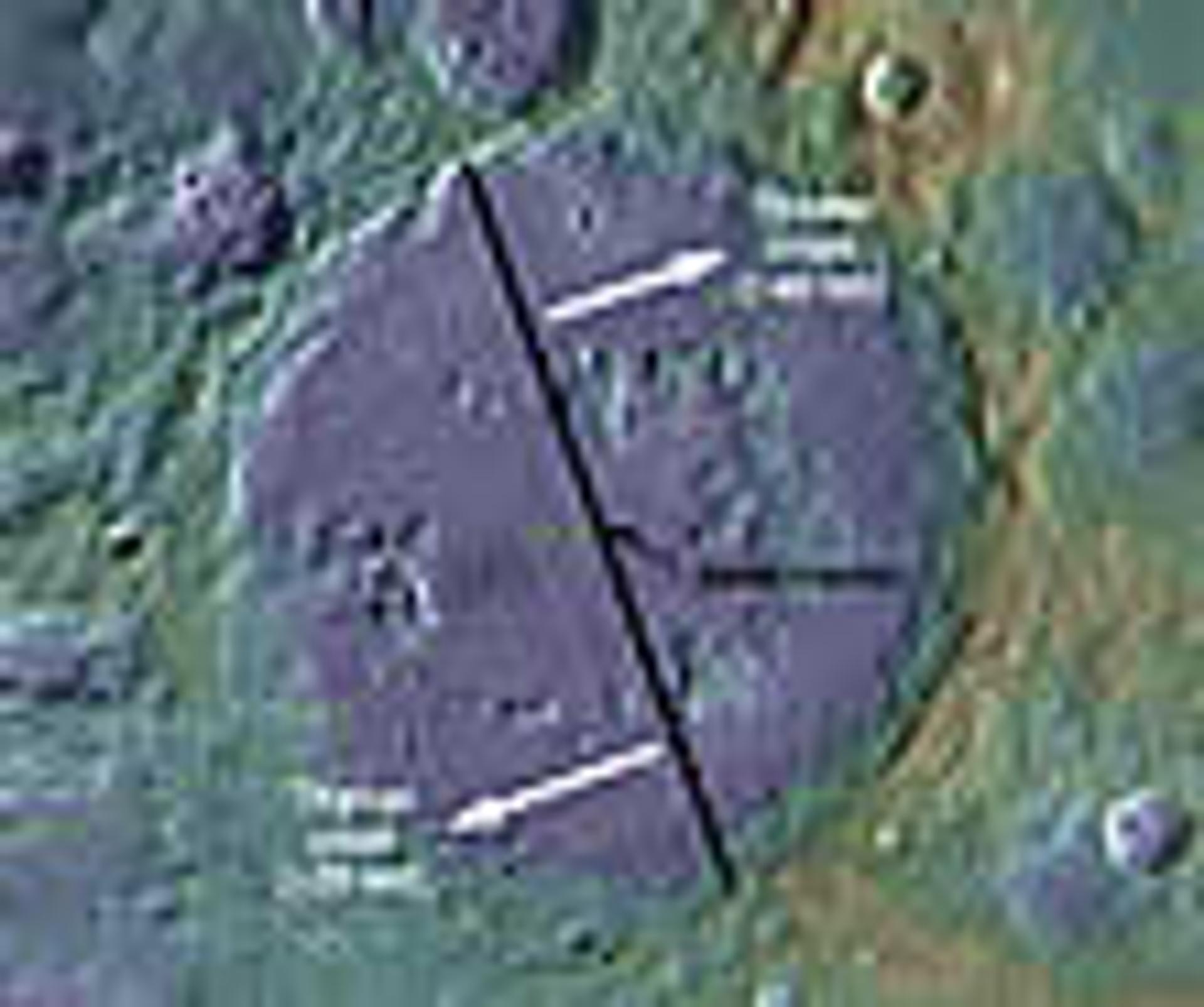
Pre-impact target conditions affected the formation of the peak ring in the ~320-km-diameter Schrödinger basin. In this view oriented with the south pole toward the top of the image, the peak ring collapsed below the level of the impact melt and breccia fill in the southeast quadrant. Also, differences in crustal thickness affected the morphology of the peak ring, producing bilateral asymmetry.
Chicxulub
The subsurface morphological character of the peak ring of the Chicxulub crater is similar to that of Schrödinger, although the topography on the upper surface of Chicxulub’s peak ring is more subdued because of Earth’s greater gravity. Thus, while Schrödinger’s peak ring rises up to 2.5 km above the basin floor, seismic reflection data (Morgan et al., 2000) indicate Chicxulub’s peak ring had ~400 m of relief before being buried. Additional seismic data suggest the peak ring varied in height circumferentially (Gulick et al., 2013), with reduced topography and thickening of the post-impact section in the northeast quadrant of the structure producing an anomalous gravity low (Fig. 1, inset). The offshore asymmetry in gravity data may be due to lateral variations in the continental shelf of the target which, in the northeast direction, is argued to have been thicker, topographically lower, and covered with deeper water at the time of impact (Gulick et al., 2008). Based in part on that assessment, Expedition 364 was designed to drill into the northwest quadrant (Morgan et al., 2016; Gulick et al., 2017), where seismic reflection data clearly image a high-relief peak ring that is relatively close to the surface (Morgan et al., 2011).
The borehole was drilled at Site M0077 (21.45° N, 89.95° W) a few kilometers north of the coastline in ~20 m water depth (Morgan et al., 2016). Those shallow water depths required the use of a leased jack-up platform or lift boat rather than one of the larger IODP ships (Gulick et al., 2017). The L/B Myrtle was anchored 5 April 2016 and drilling occurred from 7 April to 26 May 2016, followed by downhole logging and jack down of the platform on 30 May. Core recovery began at 505.7 mbsf and continued to 1334.7 mbsf with >99% recovery. The operator was able to maintain PQ3 core barrels from 701 m to the base of the borehole, producing ~83-mm-diameter core, which is wide for ocean drilling. Because the platform was so small, only limited measurements and core descriptions could be undertaken before the core was placed into refrigerated storage and shipped to the Bremen Core Repository, Center for Marine Environmental Sciences (MARUM), University of Bremen, Germany. The science party convened in Bremen in September and October 2016 to split the core into two halves, perform a suite of standard IODP measurements, and log and sample the core.
Impactites consisting of melt-bearing breccias (suevites) and impact melt rock were encountered at 617.33 mbsf and formed an ~130-m-thick unit over granite and related basement rock types within the uplifted peak ring (Fig. 4). Thin, <1-m-thick melt horizons were logged within the granite. Also, ~4 m of melt and melt-bearing breccias were encountered at ~1000 mbsf, and ~58 m of melt and melt-bearing breccias occur in the lowest 100 m of core. The rock sequence encountered within the borehole is in accordance with prior interpretations of seismic reflection and refraction data (Morgan et al., 2000, 2011; Gulick et al., 2013), including correctly predicting (1) the depth to the top of the peak ring, (2) that the uppermost peak ring is formed from ~150 m of low-velocity impact breccia, and (3) that the peak-ring rocks comprised heavily fractured basement. The total thickness of the granite-dominated basement interval is 588 m and, based on seismic reflection data (Morgan et al., 2000; Gulick et al., 2013), is predicted to continue to depths of ~3 km at the site of the borehole.
Figure 4
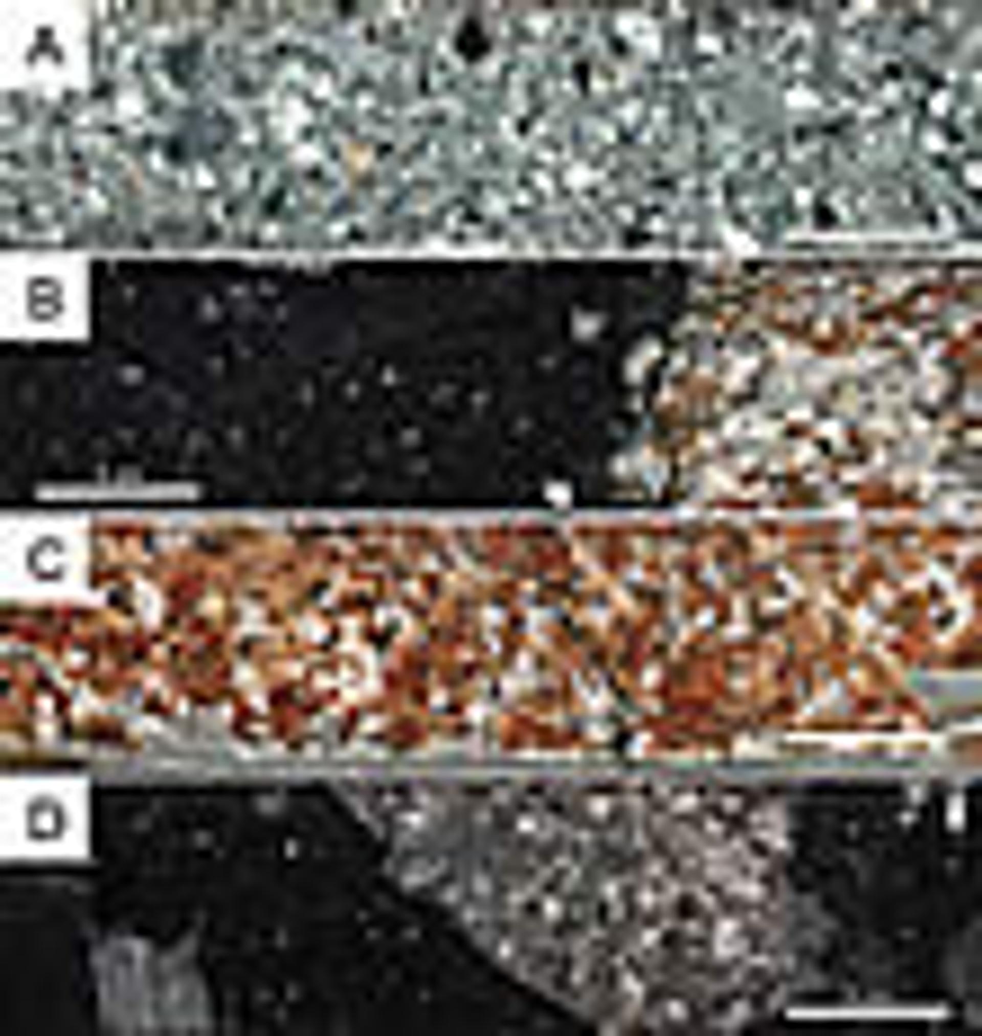
Representative core segments. (A) Suevite from ~645 mbsf contains fragments of impact melt, sedimentary target rocks, and igneous target rocks. (B) Melt rock from ~745 mbsf contains igneous clasts, dominated by granite. (C) Granite from ~814 mbsf with a gray-colored cataclastic vein. (D) Melt rock from ~1268 mbsf contains metamorphic and igneous clasts. The top of each core segment is located on the left.
The recovery of uplifted granitic rocks from the peak ring (Fig. 5) favors a dynamic collapse model for an over-heightened central uplift (Morgan et al., 2016), which is consistent with observations at other terrestrial craters (Grieve et al., 1981) and with an earlier set of numerical models of the Chicxulub-forming event (Collins et al., 2002; Ivanov, 2005; Collins et al., 2008). It is also similar to the processes inferred from geologic mapping and numerical modeling of the Schrödinger peak ring on the Moon (Kring et al., 2016). Shock metamorphism in the recovered Chicxulub peak-ring core samples indicates pressures of ~10–35 GPa, which are also consistent with a new, higher-fidelity numerical model of dynamic collapse at Chicxulub (Morgan et al., 2016). Confidence in the dynamic collapse model, finally tested with core samples, has grown substantially.
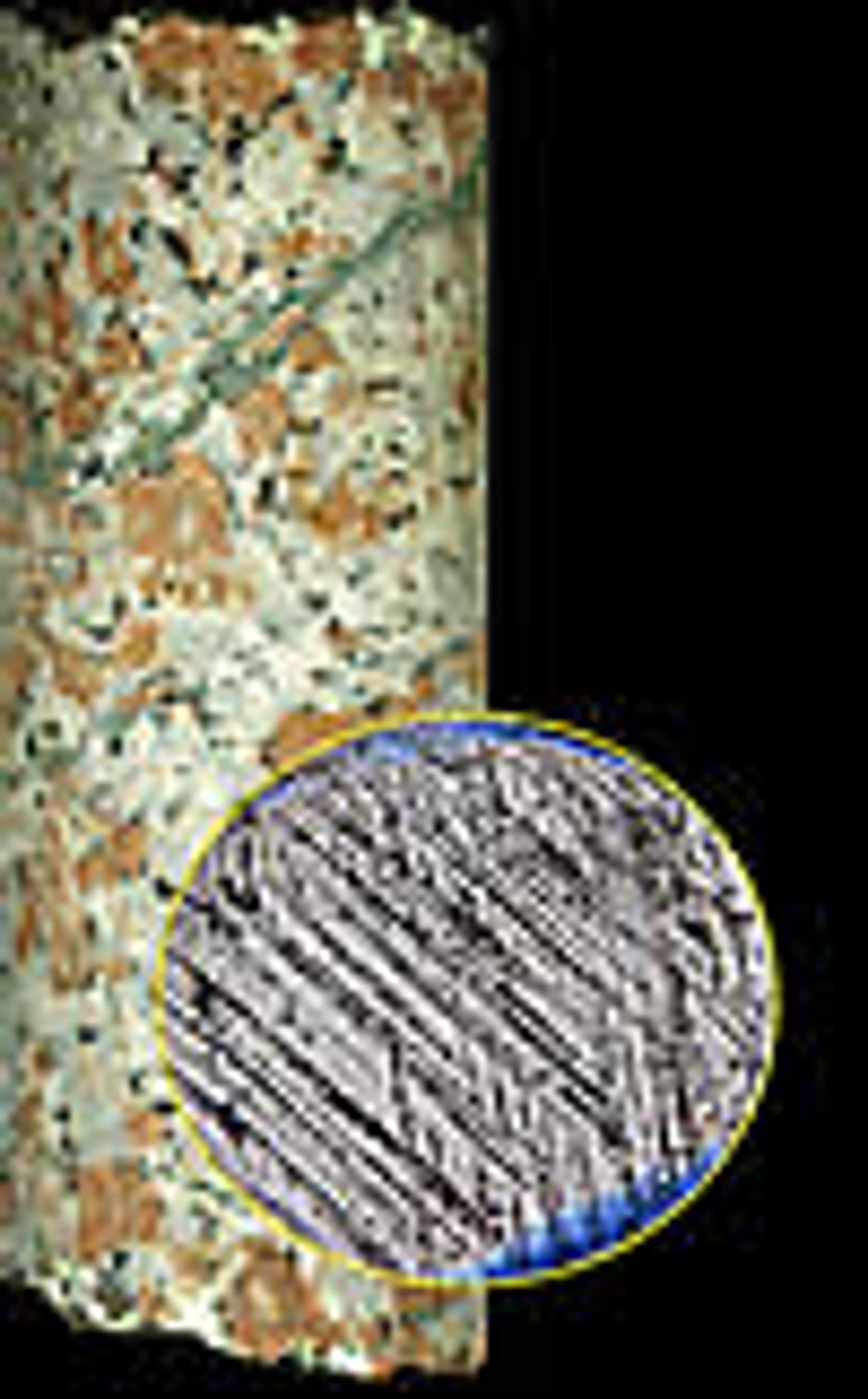
Figure 5
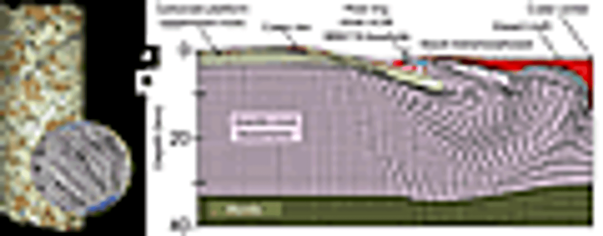
(A) The Chicxulub peak ring in 83-mm-diameter core is composed of granitic rocks, crosscut with cataclastic and hydrothermal veins, that have also been shock-metamorphosed, as illustrated with planar deformation features with ~5 micron spacing in quartz (inset, with field of view 245 microns wide). Photomicrograph of quartz by expedition scientist Ludovic Ferrière. (B) Granitic basement (pink) was uplifted and then collapsed outward over the pre-impact crust (yellow). The portion of the peak ring sampled in the core also contains shock-metamorphosed (blue) and melted (red) components, which are consistent with a numerical model of dynamic collapse of a central uplift during the crater-forming event (Morgan et al., 2016). While the numerical model treats the basement as a uniform unit of granite, which is the rock type that dominates the new IODP-ICDP core, the basement also contains metaquartzite, mica schist, granitic gneiss, gneiss, amphibolite, dolerite dikes, dacite, felsite, and granodiorite (Kring, 2005; Gulick et al., 2017).
The Chicxulub peak ring had an elevation below that of the crater rim. As inferred from analogy with the Schrödinger basin peak ring, and inferred from seismic reflection data, the peak ring had a topographically complex surface. There were highs subject to erosion and lows suitable for near-continuous sedimentation. Initial results suggest M0077A is located in a protected catchment with a rich post-impact sedimentary and paleontologic record. The expedition members are currently studying the sedimentation and biological processes that immediately followed the impact event, the nature of the sea that filled the basin, the chemical evolution of those waters as they were affected by a venting impact-generated hydrothermal system, and mixing with sea water from outside the basin, up to and including sediments associated with the Paleocene-Eocene Thermal Maximum. The underlying peak-ring basement samples of the Yucatán Peninsula will, in addition to our evaluation of impact, be useful for assessing the tectonic evolution of the Maya Block and its assembly along the margins of both the Caribbean and Gulf of Mexico basins. Measuring the ages of intrusive components within the core will better refine those processes.
Conclusions
New IODP-ICDP borehole data indicate that the peak-ring morphology of the Chicxulub crater was produced by the dynamic collapse of an uplifted central peak. Additional exciting expedition results are forthcoming. The impact generated an environmental calamity that extinguished life. It also induced a vast sub-surface hydrothermal system that altered a portion of the Maya Block and serves as a proxy for much larger and more frequently generated hydrothermal systems during the Hadean, when bombardment rates were high. And, finally, the crater became an oasis for the recovery of life and allowed expansion into momentarily vacant niches that, when filled, defined the modern world.
Acknowledgments
The IODP-ICDP Expedition 364 Science Party is composed of co-authors S. Gulick (U.S.); J.V. Morgan (UK); T. Bralower (U.S.); E. Chenot (France); G. Christeson (U.S.); Ph. Claeys (Belgium); C. Cockell (UK); M.J.L. Coolen (Australia); L. Ferrière (Austria); C. Gebhardt (Germany); K. Goto (Japan); H. Jones (U.S.); D.A. Kring (U.S.); J. Lofi (France); C. Lowery (U.S.); C. Mellett (UK); R. Ocampo-Torres (France); L. Perez-Cruz (Mexico); A. Pickersgill (UK); M. Poelchau (Germany); A. Rae (UK); C. Rasmussen (U.S.); M. Rebolledo-Vieyra (Mexico); U. Riller (Germany); H. Sato (Japan); J. Smit (Netherlands); S. Tikoo (U.S.); N. Tomioka (Japan); J. Urrutia-Fucugauchi (Mexico); M. Whalen (U.S.); A. Wittmann (U.S.); L. Xiao (China); K.E. Yamaguchi (Japan); and W. Zylberman (France). The European Consortium for Ocean Research Drilling (ECORD) implemented Expedition 364 with contributions and logistical support from the Yucatán state government and Universidad Nacional Autónoma de México (UNAM). We thank Wright Horton and Christian Koeberl for helpful reviews.
References Cited
- Claeys, P., Heuschkel, S., Lounejeva-Baturina, E., Sanchez-Rubio, G., and Stöffler, D., 2003, The suevite of the Chicxulub impact crater: Meteoritics & Planetary Science, v. 38, p. 1299–1317, doi:10.1111/j.1945-5100.2003.tb00315.x.
- Collins, G.S., Melosh, H.J., Morgan, J.V., and Warner, M.R., 2002, Hydrocode simulations of Chicxulub Crater collapse and peak-ring formation: Icarus, v. 157, p. 24–33, doi:10.1006/icar.2002.6822.
- Collins, G.S., Morgan, J.V., Barton, P., Christeson, G.L., Gulick, S., Urrutia-Fucugauchi, J., Warner, M.R., and Wünnemann, K., 2008, Dynamic modeling suggests terrace zone asymmetry in the Chicxulub crater is caused by target heterogeneity: Earth and Planetary Science Letters, v. 270, p. 221–230, doi:10.1016/j.epsl.2008.03.032.
- Cornejo Toledo, A., and Hernandez Osuna, A., 1950, Las anomalias gravimetricas en la cuenca salina del istmo, planicie costera de Tabasco, Campeche y Peninsula de Yucatán: Boletín de la Asociación Mexicana de Geólogos Petroleros, v. 2, p. 453–460.
- Grieve, R.A.F., Robertson, P.B., and Dence, M.R., 1981, Constraints on the formation of ring impact structures, based on terrestrial data, in Schultz, P.H., and Merrill, R.B., eds., Multi-Ring Basins: Proceedings of Lunar and Planetary Science, v. 12A, p. 37–57.
- Gulick, S.P.S., Barton, P.J., Christeson, G.L., Morgan, J.V., McDonald, M., Mendoza-Cervantes, K., Pearson, Z.F., Surendra, A., Urrutia-Fucugauchi, J., Vermeesch, P.M., and Warner, M.R., 2008, Importance of pre-impact crustal structure for the asymmetry of the Chicxulub impact crater: Nature Geoscience, v. 1, p. 131–135, doi:10.1038/ngeo103.
- Gulick, S.P.S., Christeson, G.L., Barton, P.J., Grieve, R.A.F., Morgan, J.V., and Urrutia-Fucugauchi, J., 2013, Geophysical characterization of the Chicxulub Impact Crater: Reviews of Geophysics, v. 51, p. 31–52, doi:10.1002/rog.20007.
- Gulick, S., Morgan, J., and Mellett, C.L., and the Expedition 364 Scientists, 2017, Expedition 364 Preliminary Report: Chicxulub: Drilling the K-Pg Impact Crater: International Ocean Discovery Program, 38 p., http://dx.doi.org/10.14379/iodp.pr.364.2017.
- Hildebrand, A.R., Penfield, G.T., Kring, D.A., Pilkington, M., Camargo-Z., A., Jacobsen, S.B., and Boynton, W.V., 1991, Chicxulub Crater: A possible Cretaceous/Tertiary boundary impact crater on the Yucatán Peninsula, Mexico: Geology, v. 19, p. 867–871, doi:10.1130/0091-7613(1991)019<0867:CCAPCT>2.3.CO;2.
- Ivanov, B.A., 2005, Numerical modeling of the largest terrestrial meteorite craters: Solar System Research, v. 39, no. 5, p. 381–409, doi:10.1007/s11208-005-0051-0.
- Jull, A.J.T., editor, 2004a, Meteoritics & Planetary Science, v. 39, no. 6, p. 787–1016, doi:10.1111/j.1945-5100.2004.tb00928.x.
- Jull, A.J.T., editor, 2004b, Meteoritics & Planetary Science, v. 39, no. 7, p. 1019–1247, doi:10.1111/j.1945-5100.2004.tb01127.x.
- Kramer, G.Y., Kring, D.A., Nahm, A.L., and Pieters, C.M., 2013, Spectral and photogeologic mapping of Schrödinger Basin and implications for the post-South Pole-Aitken impact deep subsurface stratigraphy: Icarus, v. 223, p. 131–148, doi:10.1016/j.icarus.2012.11.008.
- Kring, D.A., 2000, Impact events and their effects on the origin, evolution, and distribution of life: GSA Today, v. 10, no. 8, p. 1–7.
- Kring, D.A., 2005, Hypervelocity collisions into continental crust composed of sediments and an underlying crystalline basement: Comparing the Ries (~24 km) and Chicxulub (~180 km) impact craters: Chemie der Erde, v. 65, p. 1–46, doi:10.1016/j.chemer.2004.10.003.
- Kring, D.A., 2007, The Chicxulub impact event and its environmental consequences at the Cretaceous-Tertiary boundary: Palaeogeography, Palaeoclimatology, Palaeoecology, v. 255, p. 4–21, doi:10.1016/j.palaeo.2007.02.037.
- Kring, D.A., and Boynton, W.V., 1992, Petrogenesis of an augite-bearing melt rock in the Chicxulub structure and its relationship to K/T impact spherules in Haiti: Nature, v. 358, p. 141–144, doi:10.1038/358141a0.
- Kring, D.A., Hildebrand, A.R., and Boynton, W.V., 1991, The petrology of an andesitic melt rock and a polymict breccia from the interior of the Chicxulub structure, Yucatán, Mexico: Lunar and Planetary Science XXII, p. 755–756.
- Kring, D.A., Kramer, G.Y., Collins, G.S., Potter, R.W.K., and Chandnani, M., 2016, Peak-ring structure and kinematics from a multi-disciplinary study of the Schrödinger impact basin: Nature Communications, v. 7, 10 p., doi:10.1038/ncomms13161.
- Morgan, J., Warner, M., the Chicxulub Working Group, Brittan, J., Buffler, R., Camargo, A., Christeson, G., Denton, P., Hildebrand, A., Hobbs, R., Macintyre, H., Mackenzie, G., Maguire, P., Marin, L., Nakamura, Y., Pilkington, M., Sharpton, V., Snyder, D., Suarez, G., and Trejo, A., 1997, Size and morphology of the Chicxulub impact crater: Nature, v. 390, p. 472–476, doi:10.1038/37291.
- Morgan, J.V., Warner, M.R., Collins, G.S., Melosh, H.J., and Christeson, G.L., 2000, Peak ring formation in large impact craters: Earth and Planetary Science Letters, v. 183, p. 347–354, doi:10.1016/S0012-821X(00)00307-1.
- Morgan, J.V., Warner, M.R., Collins, G.S., Grieve, R.A.F., Christeson, G.L., Gulick, S.P.S., and Barton, P.J., 2011, Full waveform tomographic images of the peak ring at the Chicxulub impact crater: Journal of Geophysical Research, Solid Earth, v. 116, B6, 14 p., B06303, doi:10.1029/2010JB008015.
- Morgan, J.V., Gulick, S.P.S., Bralower, T., Chenot, E., Christeson, G., Claeys, P., Cockell, C., Collins, G.S., Coolen, M.J.L., Ferrière, L., Gebhardt, C., Goto, K., Jones, H., Kring, D.A., Le Ber, E., Lofi, J., Long, X., Lowery, C., Mellett, C., Ocampo-Torres, R., Osinski, G.R., Perez-Cruz, L., Pickersgill, A., Poelchau, M., Rae, A., Rasmussen, C., Rebolledo-Vieyra, M., Riller, U., Sato, H., Schmitt, D.R., Smit, J., Tikoo, S., Tomioka, N., Urrutia-Fucugauchi, J., Whalen, M., Wittmann, A., Yamaguchi, K.E., and Zylberman, W., 2016, The formation of peak rings in large impact craters: Science, v. 354, p. 878–882, doi:10.1126/science.aah6561.
- Potts, J.J., Gullickson, A.L., Curran, N.M., Dhaliwal, K., Leader, M.K., Rege, R.N., Klaus, K.K., and Kring, D.A., 2015, Robotic traverse and sample return strategies for a lunar farside mission to the Schrödinger basin: Advances in Space Research, v. 55, p. 1241–1254, doi:10.1016/j.asr.2014.11.028.
- Schulte, P., Alegret, L., Arenillas, I., Arz, J.A., Barton, P.J., Bown, P.R., Bralower, T.J., Christeson, G.L., Claeys, P., Cockell, C.S., Collins, G.S., Deutsch, A., Goldin, T.J., Goto, K., Grajeles-Nishimura, J.M., Grieve, R.A.F., Gulick, S.P.S., Johnson, K.R., Kiessling, W., Koeberl, C., Kring, D.A., MacLeod, K.G., Matsui, T., Melosh, J., Montanari, A., Morgan, J.V., Neal, C.R., Nichols, D.J., Norris, R.D., Pierazzo, E., Ravizza, G., Rebolledo-Vieyra, M., Reimold, W.U., Robin, E., Salge, T., Speijer, R.P., Sweet, A.R., Urrutia-Fucugauchi, J., Vajda, V., Whalen, M.T., and Willumsen, P., 2010, The Chicxulub asteroid impact and mass extinction at the Cretaceous-Paleogene Boundary: Science, v. 327, p. 1214–1218, doi:10.1126/science.1177265.
- Sharpton, V.L., Dalrymple, G.B., Marín, L.E., Ryder, G., Schuraytz, B.C., and Urrutia-Fucugauchi, J., 1992, New links between the Chicxulub impact structure and the Cretaceous/Tertiary boundary: Nature, v. 359, p. 819–821, doi:10.1038/359819a0.
- Shoemaker, E.M., Robinson, M.S., and Eliason, E.M., 1994, The South Pole region of the Moon as seen by Clementine: Science, v. 266, p. 1851–1854, doi:10.1126/science.266.5192.1851.
- Smit, J., 1999, The global stratigraphy of the Cretaceous-Tertiary boundary impact ejecta: Annual Review of Earth and Planetary Sciences, v. 27, p. 75–113, doi:10.1146/annurev.earth.27.1.75.
- Steenstra, E.S., Martin, D.J.P., McDonald, F.E., Paisarnsombat, S., Venturino, C., O’Hara, S., Calzada-Diaz, A., Bottoms, S., Leader, M.K., Klaus, K.K., van Westrenen, W., Needham, D.H., and Kring, D.A., 2016, Analysis of robotic traverses and sample sites in the Schrödinger basin for the HERACLES human-assisted sample return mission concept: Advances in Space Research, v. 58, p. 1050–1065, doi:10.1016/j.asr.2016.05.041.
- Swisher, C.C., Grajales-Nishimura, J.M., Montanari, A., Margolis, S.V., Claeys, Ph., Alvarez, W., Renne, P., Cedillo-Pardo, E., Maurrasse, F.J.-M.R., Curtis, G.H., Smit, J., and McWilliams, M.O., 1992, Coeval 40Ar/39Ar ages of 65.0 million years ago from Chicxulub crater melt rocks and Cretaceous-Tertiary boundary tektites: Science, v. 257, p. 954–958, doi:10.1126/science.257.5072.954. Urrutia-Fucugauchi, J., Marin, L., and Trjo-Garcia, A., 1996, UNAM Scientific drilling program of Chicxulub impact structure—Evidence for a 300 kilometer crater diameter: Geophysical Research Letters, v. 23, p. 1565–1568, doi:10.1029/96GL01566.
