
Page 9 - i1052-5173-30-8
P. 9
In his Presidential Address to the that were formerly time-consuming, sub- APPENDIX 2
Geological Society of America, “New jective, and of low precision.
Technology; New Geological Challenges,” Calculation of Edge Fabric
B.C. Burchfiel (2003 [published in 2004]) ACKNOWLEDGMENTS At each pixel in an image, there is a direction of
made a compelling case that the geological Jason Ash is a crucial partner in this effort, doing maximum grayscale brightness increase. We com-
pute this vector at each point by convolving the gray-
community must embrace new modes of the hard work of turning Matlab code into a stable app. scale image with a 3-by-3 Sobel kernel (Sobel and
data collecting. At that time, precise GPS We thank all the participants at various StraboSpot Feldman, 1968) to get the horizontal brightness gra-
workshops and field trips for their input into how to
measurements were revolutionizing active improve the app. We thank an anonymous reviewer dient at each pixel, and with the transpose of the ker-
tectonics and opening entirely new avenues and editor Peter Copeland for reviews that greatly im- nel to get the vertical gradient. Vectors defined by
of research. Developing and adopting new proved the presentation. John Bartley and Kevin these two components are shown in Figure 2B.
The StraboTools app downsamples the image to
mobile technology can advance our ability to Stewart were valuable sounding boards during devel- 1000 pixels on the long edge. Hence, a typical
opment, and they and Andreas Möller provided con-
perform basic field geology at the individual structive reviews of the manuscript. This work was image has 10 pixels, at each of which there is a
6
investigator level. Images and interpretations supported in part by National Science Foundation horizontal and vertical component of gradient. We
can be easily shared, discussed, and inter- grants EAR 1639724 to AFG and EAR 1347331, ICER form a 2-by-2 variance-covariance matrix from this
6
preted by scientists and the interested public. 1639734, and ICER 1639738 to JDW, and by the Mary 10 -by-2 gradient matrix and calculate its eigenvec-
tors and eigenvalues. These eigenvectors, scaled by
Citizen scientists could have a role in collect- Lily Kenan Flagler Bingham Professorship at the the corresponding eigenvalues’ square roots, are
University of North Carolina.
ing and evaluating geologic data in ways plotted in Figure 2C along with the ellipse that they
similar to that done for plants and animals define. As the vectors point perpendicular to edges,
with iNaturalist (https://www.inaturalist APPENDIX 1 and we want the dominant edge direction, we rotate
.org), with over 275,000 species identified, the ellipse 90° to produce the EFE (Fig. 2D).
The aspect ratio of the EFE is given by the square
and eBird (https://ebird.org), with more than Puzzle Answers root of the ratio of the eigenvalues of the variance-
100,000,000 bird sightings each year.
SHARING DATA
We envision that StraboTools will lead
to more sharing of data and make field-
work more transparent, reproducible, and
searchable. StraboTools was developed as
a spinoff of the StraboSpot project, which
allows field geologists to collect, store, and
share geologic data more easily. StraboSpot
is currently focused on collecting general
field data for structural geology, petrology,
sedimentary geology, and volcanology
(Walker et al., 2019). Although not yet a
direct part of StraboSpot, StraboTools data
and images can be entered into StraboSpot
and StereonetMobile (Allmendinger et al.,
2017).
SUMMARY
We have developed a mobile app that
allows field geologists to make quantitative
measurements of features such as foliation
orientation and intensity, mineral align-
ment, and mineral proportions rapidly, pre-
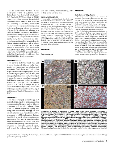
cisely, and reproducibly. The app can pick Screenshots of answers to the puzzles in Figure 1. Blue circles are for reference. (A) Foliation in
up subtle fabrics (e.g., weak foliation, flow deformed granite (Inyo Range, California, USA) has an edge fabric ellipse (EFE) aspect ratio (E) of 1.28
alignment, or pebble imbrication) that can at an azimuth of 070 in the photo. (B) This image of granodiorite (Yosemite National Park, California,
be difficult to see. It allows objective mea- USA) was deformed by pure-shear stretch of 10% along a bearing of 030 (R = 1.22); EFE gives E = 1.11
along 030. (C) Shadowed vertical face cut into alluvial deposits (Death Valley National Park, California,
surement of features that were heretofore USA), downstream to right, yields an EFE long axis rotated 20° counterclockwise from horizontal. The
subjectively evaluated or just not seen, and camera was held with a horizontal horizon, and layering is essentially horizontal, but EFEs in this and
several other photos of the same face are consistently aligned with their long axes rotated 20° to 30°
can be used to quantify fabrics in photomi- counterclockwise from horizontal. We attribute this to pebble imbrication and suggest that EFEs may
crographs and aerial photographs. It rapidly aid the detection of these subtle fabrics. (D) Color index determination on this granodiorite (Peninsular
Ranges, California, USA) yields 9% dark minerals. EFE (not shown) detects the rather obvious steep
and objectively performs fabric analyses fabric defined by alignment of the dark minerals. See the original photos in the Supplemental Material. 1
1 Supplemental Material. Original photos from Figure 1. Please visit https://doi.org/10.1130/GSAT.S.12429926 to access the supplemental material, and contact editing@
geosociety.org with any questions.
www.geosociety.org/gsatoday 9