
Full Text View
GSA Today
![]()
Article, pp. 4-9 | Abstract | PDF (2.9MB)
The smart city develops on geology: Comparing Rome and Naples
| Table of Contents |
|---|
|
Search GoogleScholar for
Search GSA Today |
ABSTRACT
A smart city is one that harmonizes with the geology of its territory and uses technology to develop sustainably. Until the Republican Times, Rome was a smart city. The ancient settlement of Rome benefitted from abundant natural resources. City expansion took place in such a way as to not substantially alter the morphological and geological features of the area; natural resources were managed so as to minimize the risks. The geology, together with prudent management, ensured Rome’s fortune. Naples, which developed in a similar geological context and at almost the same time, was exposed to more geological hazards and had access to fewer natural resources. This was fatal for the city that, while remaining one of the most important of the Mediterranean, did not become the capital of an empire as Rome did. The histories of Rome and Naples highlight the important role of geology in the development of a city and the making of its fortune. Over time, fast urban expansion, rapid population growth, and the overuse of resources led to increased hazards for both cities. As a result, the cities became unstable and fragile, and several natural processes resulted in disasters.
*Emails: de Rita: ; Häuber
DOI: 10.1130/GSATG222A.1
Manuscript received 4 June 2014; accepted 23 Dec. 2014.
Introduction
For a city to become smarter means improving the management of its infrastructure and resources to meet the present and future needs of its citizens and businesses. Smart cities are generally considered to be those that are able to invest increasingly in technology with the belief that this will ensure sustainable prosperity. Nevertheless, many past examples have shown how the indiscriminate use of technology in response to a natural hazard–induced risk, instead of generating security, can lead to higher risk and danger (Egner, 2012). We propose that a smart city is one that harmonizes with the geology of its territory and uses technology to reduce economic costs and resource consumption. In Europe, understanding how cities were born several thousand years ago may help us plan better for the future. We compare the diverse historical pasts of Rome and Naples to highlight the importance of geology in determining the fortune of one city compared to the other.
Basic Information about Rome and Naples
Rome and Naples are considered to be cities that developed by the unification of small villages in the eighth century B.C. Both cities have been shown to have existed for more than 2,500 years, during which time they experienced alternating periods of growth and decline. Rome originated from a small village in the ninth century B.C. to become, over centuries, the center of the civilization of the Mediterranean region (Soprintendenza Archeologica di Roma, 2000). The origin of Naples is connected to early Greek settlements established in the Bay of Naples around the second millennium B.C. The establishment of a larger mainland colony (Parthenope) occurred around the ninth to eighth century B.C. and was then re-founded as Naples (Neapolis) in the sixth century B.C. (Lombardo and Frisone, 2006; Giampaola and Longobardo, 2000).
Rome and Naples are located along the Tyrrhenian coast of central-southern Italy in a very young orogenic area (Fig. 1). Both cities lie on recent volcanic deposits (0.8 Ma to present) and on fluvial or coastal sediments, and are not far from the Apennine mountain chain (30–60 km). The geological evolution of the Tyrrhenian margin of Italy generated the natural resources and hazards that would affect the development of these two cities. The geological history of central Italy is driven by the collision between the African and European plates. After the formation of the Alps, part of the European plate containing the Corsica-Sardinia micro-plate broke away and started to migrate eastward, progressively colliding with the western margin of Adria (Apulia) and resulting in the formation of the Apennines (22–19 Ma; Vai and Martini, 2001). At ca. 10 Ma, rollback of the west-dipping subducting slab led to crustal thinning west of the Apennines, which created the Tyrrhenian Sea (Faccenna et al., 2001). Extensional faulting lowered the western margin of the Apennines and facilitated the development of volcanic activity in Latium (including the Sabatini and the Alban Hills volcanoes) and the Campania (Phlegrean Fields, Vesuvius, Ischia) (Peccerillo, 2005).
|
Main geological characteristics of south-central Italy, where the cities of Rome and Naples are located (modified from Butler et al., 2004). |
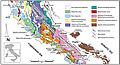 Figure 1
Comparing the Resources and Risks of Rome and Naples
From a historical-analytical perspective, Rome had more favorable geology and fewer risks than Naples. Rome developed on small hilltops that were favorable for defense and communication, and its position on the Tiber alluvial plain at the point where the Tiberina islet was located provided easy communication between the river banks (Häuber, 2013). The hills were also healthy places to live, with far fewer incidences of marsh fever, which largely affected the alluvial areas. The hills were created by the fluvial erosion of an ignimbrite plateau sloping gently from the Alban Hills volcano to the southeast. Because of this geomorphology, and the presence of the Monte Mario–Gianicolo ridge to the northwest, Rome naturally expanded to the southeast. The topography in this direction provided an area of ~800 km2 for the expansion of the city and agriculture and also provided an easy route along which to construct aqueducts.
Naples, on the other hand, was located within an easily defendable bay that drove an economy dominated by sea trade. But the rugged geomorphology of its interior territory significantly limited any other potential of the city. The Vesuvius and Phlegrean Field volcanoes defended the city from possible invaders, but they physically blocked any inland city expansion and made communication and trade with the hinterland population difficult. Over time, Naples mostly grew vertically, using as foundations the natural marine terraces bordering the coast. Geomorphology therefore played an important role in the decision of the city to develop an economy centered on the marine trade rather than agriculture.
An economy based on agriculture was much better suited to Rome, which had an abundance of fertile soils derived from volcanic and alluvial sediments. Farms were plentiful, even inside the city walls, and were mostly on the alluvial plains; they were small and family owned and ensured the self-sustenance of the city.
Rome was also favored by an abundance of water resources, such as the Tiber and Aniene rivers, and several natural springs present inside the city walls. Before the construction of the first aqueduct, the Aqua Claudia (B.C. 312; 400 years after the birth of Rome), at least 23 natural springs, with an average flow rate of more than 80 L/s, provided Rome with water. In addition, Romans drank water from the Tiber and Aniene rivers. These rivers were also highly navigable and so represented an easy and direct route for communication and trade with the hinterland. Conversely, the city of Naples did not have large freshwater resources and lacked natural springs. It also had no river and so lacked this convenient means of delivering goods to the hinterland. Most of the water in Naples was collected from shallow aquifers through a system of wells or water tanks, with a total surface area of ~10,000 m2, that stored rainwater (Kosso and Scott, 2009; Montuono, 2010). The first aqueduct, the Serino, was built during the age of Augustus (B.C. 27–14 A.D.). However, it subsequently suffered damage from the earthquakes that preceded and coincided with the Vesuvius eruption of 79 A.D.
The geological settings of Rome and Naples provided solid foundations and large resources of several different types of construction material. The ground layers for foundations both in Rome and Naples were mostly made of tuffs and consolidated coastal or alluvial sediments. Rome’s foundations are mostly on pyroclastic deposits from the Sabatini and the Alban Hills volcanic districts (Fig. 1). Both volcanoes emplaced several large-volume ignimbrites, mostly comprising lithified tuffs that were often used as building stones. Over time, rocks with increasingly better physical-mechanical characteristics were chosen and excavated at increasingly longer distances from building sites (de Rita and Giampaolo, 2006). In the late Roman Republic, the use of pozzolana (loose scoria ignimbrites) to make concrete was introduced. By mixing pozzolana with lime, Romans created a hydraulic cement that improved their ability to construct infrastructure, even underwater. Rock lavas were used for road construction and, at the peak of Rome’s development, >80,500 km of roads were stone-paved. The Romans also had a large availability of sands, clays, and gravels deposited over time by the Tiber River (Heiken et al., 2007). The abundance of these materials promoted the manufacture and use of bricks, which became very common in Roman buildings. Like Rome, Naples was built on volcanic hills, with the eastern remnants of several coalescent tuff cones and lava domes forming the Phlaegrean Fields (Fig. 1), which were emplaced prior to the violent eruptions of the Campanian Ignimbrite (39 ka) and Neapolitan Yellow Tuff ignimbrites (NYT; 15 ka). The unconsolidated facies of the NYT (pozzolana) were also frequently used to produce hydraulic cements. The NYT represented a solid but soft and easily workable ground layer for buildings, and for digging cisterns and sewers. It was the most widely used building stone in Neapolitan and regional architecture since Greek times (Cardone, 1990; de Gennaro et al., 2000). The urban development of Naples was strongly determined by the underground exploitation of tuffs that created a network of caves and tunnels (Cardone, 1990). Building materials were one of the most important economic resources for both Rome and Naples, and so mining became a very significant industry.
Both Rome and Naples suffered risks associated with frequent earthquakes, flooding, and CO2 and radon emissions. Seismicity in Rome and Naples was, and still is, mainly associated with two distinct seismogenic areas; namely, the Apennines and the volcanic districts. Earthquakes of VII–VIII Mercalli-Cancani-Sieberg scale (MCS) maximum intensity have occurred in Rome and Naples and were the result of the present extensional regime related to post-orogenic collapse of the Apennines (D’Agostino et al., 2011). The greatest effects of these earthquakes are felt where there is an alternation of soft, loose alluvial and coastal sediments with the more rigid bedrock (marine clay and volcanic sediments). The alternating soft and rigid sediments give rise to an anomalous amplification of ground motion causing buildings to be subjected to long and strong shaking; this occurred in both the historical center of Naples (Nunziata et al., 2000) and along the Tiber river valley in Rome (Heiken et al., 2007). In addition, the low-lying geological setting of Naples has been affected by huge natural and artificial geomorphological changes (Nunziata et al., 2000). Volcanic earthquakes, with maximum intensity of VIII MCS, have originated in the volcanic areas of the Alban Hills since Roman times, while eruptions of Vesuvius have often been accompanied by large earthquakes in the Apennines, 50–60 km to the northeast, such as those that occurred in 63 A.D. and 64 A.D., before the destructive Vesuvius eruption in 79 A.D. The Neapolitan area is also affected by bradyseism, the subsidence and uplifting of the ground surface caused by the volcanic and hydrothermal systems beneath the Phlegrean Fields.
Both Rome and Naples developed during long quiescent periods of their volcanoes. The last known eruption of the Alban Hills is dated ca. 29,000 yr B.P., although more recent phenomena of lahar generation from the crater of Albano have been identified (Funiciello et al., 2003). Similarly, the ancient development of Naples mainly took place during the 3,000 years of quiescence of the Phlegraean Fields and Vesuvius before the 79 A.D. eruption.
Flooding also represented another important hazard both in Rome and Naples. Because of its location close to the Tiber River delta and on parts of its alluvial plane, Rome has frequently been afflicted by floods. Fifteen floods have been described between B.C. 414 and B.C. 4 (Bersani and Bencivenga, 2001), although the Tiber was generally considered as a calm river with few floods. Up until Republican Times, flood damage had not been devastating because competent city planners had placed facilities on the floodplain and most residences on hilltop areas. However, during the Imperial period (B.C. 27–395 A.D.), settlement was also allowed across the floodplain up to the Tiber’s banks, as a result of which a large proportion of the city’s population was exposed to flooding (Lamb, 1995).
On the other hand, flooding has been a regular phenomenon throughout the history of Naples. The city developed in an area where torrential rain-fed waters flowed into several rugged canyons or gullies on the mountains that unified at the back of the city. The first flood records of the city date back to 1010 A.D., but thick alluvial deposits in the central area of the city testify to the occurrence of floods in pre-Roman time.
Magmatic activity and fault systems are also responsible for elevated toxic gas concentrations in the near-surface environments of Naples and Rome, with the gases produced at depth migrating upward along highly permeable fault zones. The most common gases are CO2 and H2S, likely formed by magma cooling and degassing, and by water-rock interactions. Sudden releases of CO2 have been documented from antiquity until the present day in several areas of the Alban Hills volcanic district. The quantity of CO2 that rises from the depths and subsequently dissolves into shallow groundwater has been estimated to be more than 4.2 × 10⁹ mol year −1 . In addition, elevated Rn comes from the high content of U and Ra present in both volcanic lavas and tuffs. In the Phlegraean Fields volcanic area, many hydrothermal phenomena, such as fumaroles and hot springs, testify to the still active volcanism of this area.
Finally, both Rome and Naples have been affected by anthropogenic hazards. The fast growth of the cities and their populations prompted the urbanization of areas subject to natural hazards, such as river and coastal flood plains previously used for agriculture, thereby exposing the population to flood risk and also reducing the ability of the city to ensure self-sustenance. Another hazard affecting both cities stems from the underground cavities that remained after the prolific quarrying for building materials. The subterranean tunnel networks were so dense and intricate that the vaults of the galleries were prone to collapse. In addition, the lack of a clear separation between water cisterns and sewers exposed the population of Naples to diseases such as cholera.
During late Republican time, continuous construction of new buildings, higher consumption of goods, and the generation and burial of the resultant waste increased the rate at which both cities rose above their original geologic foundations. In the Tiber flood plain of Rome, the anthropic debris layers are 10–15 m thick. In the historical part of Naples, the same deposits can locally reach thicknesses of 20 m (Nunziata and Panza, 2002). Debris layers generally have very poor geotechnical properties and so provide weak foundations that, in the event of an earthquake, can actually magnify seismic waves.
Urbanization also caused degradation of the hill slopes, creating unstable geomorphological conditions that can trigger landslides, especially during the occurrence of seismic tremors. The earliest evidence of slope instability and mass movement in Naples has been discovered in its ancient center, where the city market of the Imperial period (first century A.D.) is partially buried under a chaotic deposit dated to the end of the fifth century (Di Martire et al., 2012). Landslides in and around the Neapolitan area have mostly been related to human activities (around 40%), such as trenching, excavations, and quarrying (Calcaterra and Guarino, 1999). Hill slope instability in Rome was limited and mainly human-induced when urbanization expanded to the margins of valleys.
Discussion and Conclusions
Geology was a major contributor to the fortune of Rome, which had more resources and reduced risks relative to Naples. Rome could also safely expand toward the Alban Hills area because of the plateau geomorphology, which further provided an easy path for the construction of the aqueducts. The city could also develop agricultural practices that, until Republican times, ensured its self-sustenance.
Many lessons can be learned if we consider the development of Rome over time (Fig. 2). Rome evolved from a small village that covered just over 100 ha and was enclosed by a perimeter wall of 7 km. During Republican times, it expanded and was enclosed by the 11-km Servian wall. During Imperial times, Rome doubled its size in less than 300 years, attaining a perimeter of 19 km enclosed by the Aurelianic walls (Häuber, 2013). During this time, the population increased to > 1,500,000. The alluvial areas were fully covered by construction and consequently the agricultural areas within the walls disappeared. From revenues of ~540 million sesterces, state expenses included 108 million sesterces to import 3.5 × 10⁵ tons per year of wheat to sustain as much as half the population. In addition, 31–65 million denari (1/4 denario = 1 sesterce) was devoted to military operating costs. Kehoe (1988) estimated that, during the Roman Empire, the population consumed ~200,000 metric tons of wheat annually. A family of six people needed to grow crops on at least 3 ha of land in order to survive. This meant that for self-sustenance, the Roman population needed at least 500,000 ha, an area of land greatly exceeding that which was available around Rome. So Rome became dependent on food imported from overseas to feed the general population and had to harness the resources of its provinces in order to feed and support the revenue of its army, which was spread throughout the empire.
|
Evolution of Rome from Archaic to Imperial times (Häuber, 2014). |
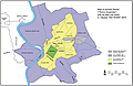 Figure 2
Naples had a different set of problems due to its geological setting and interactions between natural and anthropic dynamics that culminated in numerous risks. Primarily, the difficult terrain surrounding the city severely limited urban expansion (Fig. 3). Steep hills and narrow, abrupt volcanic ridges formed unsurmountable obstacles not only to city expansion but also to communications with the hinterland. This rugged geomorphology and bradyseism forced the city to grow vertically, with a resulting increase in landslide risk. To add to Naples’ problems, water resources were scarce and flash-flooding resulting from the sloped terrain frequently wreaked havoc throughout the city. In spite of these problems, Naples was always an important port city, well connected with Greece and Greek culture. On one hand, this was a fortunate situation, but on the other, it caused rapid overcrowding of a city without the necessary local resources. Urban overgrowth and substantial increases in the population were always followed by economic crises and the rapid development of epidemics that resulted in decimation of the population at various points in its history.
|
Air photo of Naples showing the extent of the city walls. The red line shows the approximate extent of Naples during the fifth century B.C.; the blue line encloses the enlargement of the city during the fourth century A.D.; the green line shows the wall added during the Angevin period; the violet line shows the extension of the wall during the Aragonese period; the orange line shows the extent of the wall during the Viceroy period (modified from Amato et al., 2009). |
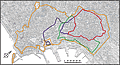 Figure 3
Geological knowledge is therefore essential for the sustainable development of a city. The fortune of Rome until Republican times was sourced in the abundance of local resources and in the practical management of the land that ensured reduction of natural risks. With more geological hazards and limited resources, Naples was less fortunate in comparison.
Acknowledgments
This work benefited from a three month senior fellowship from the Rachel Carson Center of Munich (2012) to D. de Rita. Particular thanks are due to Prof. Don Dingwell. A warm thank-you goes to our colleague Neil Thomas Ellwood for the careful review of the final version of the English text. Finally, we are grateful to the two anonymous reviewers whose suggestions and criticisms have helped to improve the text.
REFERENCES CITED
- Amato, L., Carsana, V., Cinque, A., Di Donato, V., Giampaola, D., Guastaferro, C., Irollo, G., Morhange, C., Romano, P., Ruello, M.R., and Russo Ermolli, E., 2009, Evoluzione del paesaggio costiero tra Parthenope e Neapolis: Méditerranée, v. 112, p. 23–31.
- Bersani, P., and Bencivenga, M., 2001, Le piene del Tevere a Roma dal V secolo a.C. all’anno 2000: Presidenza del Consiglio dei Ministri, Servizio Idrografico e Mareografico Nazionale, 114 p.
- Butler, R.W.H., Mazzoli, S., Corrado, S., de Donatis, M., Scorcca, D., Di Bucci, D., Gabini, R., Naso, G., Nicolai, C., Shiner, P., and Zucconi, V., 2004, Applying thick-skinned tectonic models to the Apennine thrust belt of Italy: Limitations and implications, in McClay, K.R., ed., Thrust Tectonics and Hydrocarbon Systems: AAPG Memoir 82, p. 647–667.
- Calcaterra, D., and Guarino, P.M., 1999, Morphodynamics and recent landslides in the Neapolitan slopes (western sector): Geologia Tecnica ed Ambientale, no. 2/99, p. 11–17.
- Cardone, V., 1990, Il tufo nudo nell’architettura napoletana: Napoli, Ed. Cuen, 225 p.
- D’Agostino, N., D’Anastasio, E., Gervasi, A., Guerra, I., Nedimovic, M.R., Seeber, L., and Steckler, M., 2011, Forearc extension and slow rollback of the Calabrian Arc from GPS measurements: Geophysical Research Letters, v. 38, L17304, doi: 10.1029/2011GL048270.
- de’ Gennaro, M., Calcaterra, D., Cappelletti, P., Langella, A., and Morra, V., 2000, Building stone and related weathering in the architecture of the ancient city of Naples: Journal of Cultural Heritage, v. 1, p. 399–414, doi: 10.1016/S1296-2074(00)01096-7.
- de Rita, D., and Giampaolo, C., 2006, A case study—Ancient Rome was built with volcanic stones from the roman land, in Heiken, G., ed., Tuffs: Their Properties, Uses, Hydrology and Resources: Geological Society of America Special Paper 408, p. 127–131.
- di Martire, D., De Rosa, M., Pesce, V., Santangelo, M.A., and Calcaterra, D., 2012, Landslide hazard and land management in high-density urban areas of Campania region, Italy: Natural Hazards and Earth System Sciences, v. 12, p. 905–926, doi: 10.5194/nhess-12-905-2012.
- Egner, H., 2012, Risk, space and natural disasters: On the role of space and nature in risk research, in Mauch, C., and Mayer, S., eds., American Environments: Climate, Cultures, Catastrophe: Heidelberg, Winter Universitätsverlag, p. 57–77.
- Faccenna, C., Becker, T.W., Lucente, F.P., Jolivet, L., and Rossetti, F., 2001, History of subduction and back-arc extension in the Central Mediterranean: Geophysical Journal International, v. 145, p. 809–820, doi: 10.1046/j.0956-540x.2001.01435.x.
- Funiciello, R., Giordano, G., and De Rita, D., 2003, The Albano maar lake (Colli Albani Volcano, Italy): Recent volcanic activity and evidence of pre-Roman Age catastrophic lahar events: Journal of Volcanology and Geothermal Research, v. 123, no. 1–2, p. 43–61.
- Giampaola, D., and Longobardo, F., 2000, Naples Greek and Roman: Naples, Electa, 64 p.
- Häuber, C., 2013, Archäologische Stadtforschung. I. Das Beispiel Rom, in Mieg, H.A., and Heyl, C., eds., Stadt. Ein interdisziplinäres Handbuch: Stuttgart, Weimar, p. 148–163.
- Häuber, C., 2014, Digitale Topographie der Stadt Rom: Leibniz-Rechenzentrum der Bayerischen Akademie der Wissenschaften, 18 Dec. 2014, http://www.rom.geographie.uni-muenchen.de/ (last accessed 2 Jan. 2014).
- Heiken, G., Funiciello, R., and De Rita, D., 2007, The Seven Hills of Rome. A Geological Tour of the Eternal City: New Jersey, Princeton University Press, 243 p.
- Kehoe, D., 1988, Economics of Agriculture on Roman Imperial Estates in North Africa: Göttingen, Vandenhoeck & Ruprecht, 266 p.
- Kosso, C., and Scott, A., 2009, The nature and function of water, baths, bathing, and hygiene from antiquity through the Renaissance: Technology and Change in History, v. 11, p. 21–42.
- Lamb, H., 1995, Climate, History and the Modern World: London, Routledge, 433 p.
- Lombardo, M., and Frisone, F., 2006, Colonie di colonie: Le fondazioni sub-coloniali greche tra colonizzazione e colonialismo: Atti del Convegno Internazionale di studi, Congedo Ed., Galatina 2010, 198 p.
- Montuono, G.M., 2010, L’approvvigionamento idrico della città di Napoli. L’acquedotto del Serino e il Formale Reale in un manoscritto della Biblioteca Nazionale di Madrid: Atti del Terzo Convegno Nazionale di Storia dell’Ingegneria, Naples, April 2010, p. 1029–1050.
- Nunziata, C., and Panza, G.F., 2002, A contribution to the microzoning of Napoli: Memorie Società Geologica Italiana, v. 57, no. 2, p. 431–436.
- Nunziata, C., Costa, G., Marrara, F., and Panza, G.F., 2000, Validated estimation of the response spectra for the 1980 Irpinia earthquake in the eastern area of Naples: Earthquake Spectra, v. 16, no. 3, p. 643–660, doi: 10.1193/1.1586132.
- Peccerillo, A., 2005, Plio-Quaternary Volcanism in Italy: Berlin, Springer, 365 p.
- Soprintendenza Archeologica di Roma, 2000 Roma, Romolo, Remo e la fondazione della città: Milano, Electa, 367 p.
- Vai, G.B., and Martini, I.P., 2001, Anatomy of an orogen: The Apennines and Adjacent Mediterranean Basins: Dordrecht, Kluver Academic Publishers, 632 p.