
Full Text View
Volume 23 Issue 11 (November 2013)
GSA Today
![]()
Article, pp. 4-10 | | Abstract | PDF (3MB)
Late Oligocene–early Miocene Grand Canyon: A Canadian connection?
| Table of Contents |
|---|
|
Search GoogleScholar for
Search GSA Today |
ABSTRACT
Remnants of fluvial sediments and their paleovalleys may map out a late Oligocene–early Miocene “super-river” from headwaters in the southern Colorado Plateau, through a proto–Grand Canyon to the Labrador Sea, where delta deposits contain microfossils that may have been derived from the southwestern United States. The delta may explain the fate of sediment that was denuded from the southern Colorado Plateau during late Oligocene–early Miocene time.
I propose the following model:
- Uplift of the Rio Grande Rift cut the southern Colorado Plateau out of the Great Plains at 26 Ma and tilted it to the southwest.
- The upper Colorado River and its tributaries began as consequent streams that flowed down the structural plunge of the basin toward the southwest corner of the Colorado Plateau, where the river passed through a Paleogene canyon.
- The river turned north in the Lake Mead region to enter Paleogene rifts of the eastern Great Basin.
- NE-trending grabens across the Idaho and Montana Rockies provided the final link to the Great Plains, where the Miocene drainage joined the “Bell River” of Canada, which drained to the Labrador Sea.
- Faulting and volcanism began to segment the paleo-river by ca. 16 Ma.
- Faulting dammed Miocene Grand Canyon, creating a large ephemeral lake that persisted until after 6 Ma, when the Colorado River was captured by the Gulf of California.
- The resulting shortcut to sea level greatly increased the gradient of the Colorado River, leading to headward incision of the Inner Gorge of Grand Canyon along the trace of the Miocene bedrock valley floor and renewed late Miocene-Holocene erosion of the Colorado Plateau.
- The Yellowstone hotspot cut the river off in Idaho after 6 Ma.
- Pleistocene continental glaciation destroyed the Canadian Bell River and diverted Montana’s drainage into the modern Missouri River.
*Email:
Manuscript received 3 April 2013; accepted 30 June 2013
DOI: 10.1130/GSATG178A.1
Introduction
Apatite fission track and (U-Th)/He data indicate that Grand Canyon probably existed in some form by late Oligocene–early Miocene time (Flowers et al., 2008; Wernicke, 2011; Cather et al., 2012; Flowers and Farley, 2012; Lee et al., 2013). However, the fate of its eroded sediment remains uncertain, as does the outlet of a hypothetical late Oligocene–early Miocene Colorado River (Karlstrom et al., 2012); the river did not reach the Gulf of California until 5.3 Ma (Dorsey et al., 2005). Several researchers have concluded that an early Miocene Colorado River most likely would have flowed northwest from a proto–Grand Canyon, because geologic barriers blocked avenues to the south and east (Lucchitta et al., 2011; Cather et al., 2012; Dickinson, 2013).
Here I propose that a late Oligocene–early Miocene Colorado River could have turned north in the Lake Mead region to follow paleovalleys and rift systems through Nevada and Idaho to the upper Missouri River in Montana. The upper Missouri joined the South Saskatchewan River of Canada before Pleistocene continental ice-sheets deflected it to the Mississippi (Howard, 1958). The South Saskatchewan was a branch of the pre-ice age “Bell River” of Canada (Fig. 1), which discharged into a massive delta in the Saglek basin of the Labrador Sea (McMillan, 1973; Balkwill et al., 1990; Duk-Rodkin and Hughes, 1994). Could the late Oligocene–early Miocene Colorado River have ultimately discharged into the Labrador Sea?
|
Early Oligocene drainage off North American Cordilleran highlands. 1—Cypress Hills and Wood Mountain; 2—Western Grand Canyon; after Duk-Rodkin and Hughes (1994). See Figure 2 for key to abbreviations. |
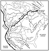 Figure 1
The following paragraphs outline geologic evidence for the evolution of a proposed late Oligocene–early Miocene paleovalley from Canada upstream to the Colorado Plateau, and suggest tests at critical linkages between proposed paleovalley segments. Figures 1, 2, and 3 summarize the proposed evolution of the drainage.
|
Miocene North American drainage. Rio Grande Rift has cut off western headwaters of Mississippi River and created upper Colorado basin, which drains into eastern Great Basin rift. 1—Cypress Hills and Wood Mountain; 2—Upper Missouri River; 3—Eastern Great Basin rift; 4—Early Grand Canyon; HB—Hudson Bay; HS—Hudson Strait; LCL—Lewis and Clark Line; NAMC—Northwest Atlantic Mid-Ocean Channel; RG—Rio Grande; RMT—Rocky Mountain Trench; S SASK—South Saskatchewan River; U. COLO—Upper Colorado River. |
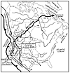 Figure 2
|
Pleistocene North American drainage. Continental ice sheets turn Montana drainage into modern Missouri. Yellowstone hotspot track has cut off Miocene River. Faulting in SE Nevada has diverted Colorado River to Gulf of California. HB—Hudson Bay; HS—Hudson Strait; NAMC—North Atlantic Mid-Ocean Channel; SRP—Snake River Plain, S SASK—South Saskatchewan River; YHS—Yellowstone hotspot. |
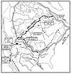 Figure 3
Bell River of Canada and Its Delta
The Cenozoic Bell River basin (McMillan, 1973) drained most of Canada before the basin was destroyed by Pleistocene continental glaciation. The tributaries gathered in the area of Hudson Bay and flowed out to sea through Hudson Strait (Duk-Rodkin and Hughes, 1994). Headwater valleys are preserved in the Rocky Mountains, Mackenzie Mountains, and northern Great Plains. The South Saskatchewan River, its main southern tributary, had sources in the Montana Rockies (Leckie et al., 2004).
The Bell River fed the >8-km-thick Saglek delta deposit in the Labrador Sea (Jauer and Budkewitsch, 2010). This delta comprises the largest sedimentary depocenter on the Atlantic seaboard of North America (Balkwill et al., 1990). An indication of the magnitude of the Bell River basin is given by the Northwest Atlantic Mid-Ocean Channel, one of the longest in the world, which winds along the seafloor for 3400 km, from the foot of the delta to the Sohm Abyssal Plain, east of New England. Continental glaciation beheaded the Saglek delta at Hudson Strait (Jauer and Budkewitsch, 2010).
Reworked fossil pollen recovered from exploration wells in the delta may support a direct link to headwaters in the Colorado Plateau. The pollen and associated sediment was derived from the western interior of North America (Hiscott, 1984; Williams, 1986). More than 15 recyclant palynomorphs identified by Williams (1986) match fossil pollen found in upper Paleozoic and lower Mesozoic continental strata that are widespread on the Colorado Plateau, but rarely crop out farther north (cf. Cook and Bally, 1975). From upper Eocene to lower Miocene muds drilled in the Roberval K-92 well of the Saglek basin, Williams (1986) identified Calamospora, Convolutispora, Densoisporites, Foveotriletes, Matonisporites, and Osmundacidites wellmanii, which are also known from the Chinle Formation of northern Arizona (cf. Litwin et al., 1991), and a Lycospora-Triquitrites-Punctatisporites assemblage, which is also known from the Supai Group of Grand Canyon (cf. McKee, 1982).
The Bell River drainage has been traced up the South Saskatchewan paleovalley to the Cypress Hills and Wood Mountain, river-gravel-capped nunatak ridges on the southern Canadian plains (Prest 1970). The gravel fills broad, overlapping Eocene to early Miocene paleovalleys (Leckie et al., 2004). Paleocurrent measurements indicate that the gravel was deposited by NNE flow in braided channels (Leckie et al., 2004). Provenance of placer gold, alkalic volcanics, and Belt Supergroup pebbles indicates derivation from the Montana Rockies (Leckie et al., 2004).
Upper Missouri Paleovalley, Montana
The South Saskatchewan paleovalley trends directly toward the upper Missouri River of northwest Montana (Fig. 4). Remnants of Miocene river gravel trace the ancestor of the upper Missouri for 350 km, from Great Falls southwest to the Continental Divide (Sears et al., 2009). Upper Missouri paleovalley segments are as broad as 10–15 km and contain Miocene fluvial deposits as thick as 200 m. The paleovalley was carved into beds as young as the Arikareean Renova Formation, and was filled by river beds as old as the Barstovian Sixmile Creek Formation (Fields et al., 1985). Active faults of the Intermountain Seismic Belt have disrupted the paleovalley (Stickney, 2007).
|
Miocene central-western United States drainage. Upper Colorado River basin (cross-hatched) drains structural trough toward southwest corner of Colorado Plateau, leading to rift systems through Nevada, Idaho, and Montana, to headwaters of South Saskatchewan River. Antler orogenic belt, Cambrian-Precambrian Z ( |
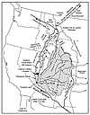 Figure 4
The upper Missouri paleovalley was superimposed over a Paleogene rift system that linked western Montana with Idaho, Nevada, and Utah (Janecke, 1994; Axen et al., 1993). The rift system and associated core complexes and high topography had propagated from Montana to southern Nevada in Eocene and Oligocene time in association with the southward-migrating Cordilleran magmatic arc (Mix et al., 2011). The rift system may have channeled volcanic ash from the magmatic in arc Nevada and Utah to Idaho and Montana, where it accumulated as thick claystone deposits in the Renova and correlative formations.
The Miocene fluvial deposits of the upper Missouri paleovalley contain an assemblage of exotic pebbles and cobbles that have no possible bedrock sources in Montana (Sears et al., 2009). These clasts diminish in grain size northeast along the paleovalley, in accord with prevailing paleocurrents (Landon and Thomas 1999). They include abundant roundstone cobbles likely derived from Cambrian-Precambrian Z quartzites of southeastern Idaho and western Utah (cf. Oriel and Armstrong, 1971), along with pebbles that match distinctive lithologies of the Antler belt of Nevada, including: (1) Eureka Quartzite, (2) Valmy chert and Vinnini quartzite of the Roberts Mountain allochthon, and (3) Diamond Peak conglomerate of the Antler overlap assemblage (cf. Coats, 1987). These lithologies were exposed on the shoulders of the Paleogene rift that linked western Montana with Idaho and Nevada. Fluvial transport down the rift axis could have brought the exotic clasts into Montana.
The gravel-filled Miocene paleovalley crosses the Continental Divide from Montana into Idaho, where it is buried by Pliocene volcanics of the Yellowstone hotspot track and Pleistocene basalt of the Snake River Plain (cf. Pierce and Morgan, 1992). The distinctive river gravel reappears in windows through the basalt more than 100 km south of the Continental Divide, where it has been exploited in gravel pits. Detrital zircon studies show that, after 6 Ma, the Continental Divide migrated east from the Idaho batholith to its present location on the Montana border (Beranek et al., 2006), where it crosses the trend of the paleovalley.
Remnants of middle and upper Miocene fluvial and lacustrine deposits occur in isolated patches above a regional unconformity along the trend of the Paleogene rift system in Nevada (Coats, 1987; Stewart and Carlson, 1978). The Paleogene rift system was segmented by basin-range faulting, and the paleovalley deposits have been variably tilted, faulted, eroded, and buried in the modern landscape (cf. Henry et al., 2011).
The Caliente caldera complex erupted near the southern end of the rift system from 26 to 15 Ma (Axen, 1998). North of the caldera complex, north-trending paleochannels contain volcanic ash and well-rounded river pebbles of Caliente volcanics along with metamorphic lithologies that were ultimately derived from basement complexes exposed farther to the south.
Remnants of Paleogene paleovalleys may connect the Paleogene rift system to western Grand Canyon. Reconstruction of basin-range faulting in the Lake Mead region restores the pre-extensional, 26–16-Ma basal Horse Spring Formation against the southwest corner of the Colorado Plateau near the western edge of Grand Canyon (Umhoefer et al., 2010). The formation was deposited on alluvial plains that sloped off the flanks of Laramide ridges into a broad north-trending paleovalley on the west edge of the plateau (Anderson and Beard, 2010). The Laramide ridges coincide with the shoulder of the Paleogene rift system mapped by Mix et al. (2011), which had propagated south to that latitude by 28 Ma. Until basin-range faulting began at 17 Ma, most of the sediment in the Horse Spring paleovalley bypassed the system toward the northeast (Lamb et al., 2010).
Early Miocene ProtoGrand Canyon?
An early Miocene paleocanyon floor may transect the entire length of Grand Canyon, midway between the rim and the river. The feature is represented by a ~5-km-wide terrace that is incised by the deep and narrow Inner Gorge. The terrace transects hundreds of meters of tilted stratigraphy as it crosses the Kaibab Upwarp, a major Laramide anticline in eastern Grand Canyon (Dickinson, 2013). It is offset by Pliocene and younger normal faults. It comprises the Hualapai Plateau in western Grand Canyon, the Esplanade terrace atop the Supai Group in central Grand Canyon, and a series of concordant buttes, mesas, spurs, and terraces on top of the Redwall Limestone in eastern Grand Canyon (Fig. 5). River-polished and fluted limestone and beheaded fluvial channels are locally preserved on the surface. The Redwall bench and Esplanade terrace are mutually exclusive; there is no Redwall bench in central and western Grand Canyon, and no Esplanade terrace in eastern Grand Canyon. They appear to be concordant parts of the same erosional surface.
|
Miocene(?) mid-canyon bench as seen on Cheops Pyramid and adjacent ridges on top of Redwall Limestone, near Phantom Ranch, eastern Grand Canyon, USA. Photo by J.W. Sears. |
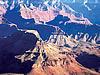 Figure 5
The Hualapai Plateau is a mature cuestaform terrace cut by deep paleocanyons that are filled with Paleogene fluvial/alluvial sediments (Young, 2008). Wernicke (2011) and Flowers and Farley (2012) deduced from apatite dating that the paleocanyons may have been cut by 70 Ma. Wernicke (2011) proposed that the Late Cretaceous “California River” flowed eastward through the proto– Grand Canyon and delivered feldspathic sediment from the Sierra Nevada to the Cretaceous Interior Seaway in southern Utah, and later reversed its flow.
The Hualapai terrace is capped by 20- to 16-Ma volcanics that flowed across the filled paleocanyons, and is incised by the narrow, 1-km-deep Inner Gorge, which cuts across ca. 6-Ma dike swarms (Billingsley and Wellmeyer, 2003).
Lee et al. (2013) concluded from apatite dating that a canyon had eroded through the Kaibab Upwarp of eastern Grand Canyon in latest Oligocene–early Miocene time (28–20 Ma). Flowers et al. (2008) deduced from apatite dating that from 23 to 16 Ma erosion had cut a ~1-km-deep canyon through the Kaibab rim. That depth would correspond to the level of the mid-canyon bedrock bench.
East of Grand Canyon, Lucchitta et al. (2011) interpreted a meandering ridge of fluvial sediment as a topographically inverted Miocene paleovalley—the “Crooked Ridge River.” The feature crosses >100 km of the Navajo Nation and may have been a major tributary or even the main stem of the ancestral Colorado River. The fluvial sediment includes minor amounts of stream-rounded gravel ultimately derived from the San Juan and Needle Mountains of Colorado (Hunt, 1969). The gradient of the Crooked Ridge River projects toward that of the 16-Ma paleovalley of the Little Colorado River basin as well as toward that of the mid-canyon bedrock bench in eastern Grand Canyon (Dickinson, 2013).
Colorado Plateau
Continental rifting separated the southern Colorado Plateau from the Great Plains beginning ca. 26 Ma (Chapin and Cather, 1994). Prior to the rifting, the region had relatively low relief and drained east from the Cordilleran highlands toward the mid-continental lowlands (Cather et al., 2008; Wernicke, 2011) (Fig. 1). The rifts formed when the western North American plate boundary became dextral-transtensional, and the crustal block that became the Colorado Plateau rotated clockwise relative to North America (Chapin and Cather, 1994). The basin is bordered by rift systems (Fig. 4). On the west is the eastern Great Basin rift and Wasatch Front, on the south, the Mogollon Highlands, on the east, the Rio Grande Rift (Chapin and Cather, 1994). The Wyoming part of the basin was not integrated until late Miocene (Cather et al., 2012).
Uplift of the rift zones created a broad structural trough that warped the mature, early Oligocene (ca. 35 Ma) Rocky Mountain erosional surface (Cather et al., 2008). The upper Colorado River and its tributaries formed a consequent drainage system that flowed down the structural trough toward the southwest corner of the Colorado Plateau. Since 26 Ma, the east side of the basin has risen nearly 3 km relative to the southwest corner (Epis and Chapin, 1975; Liu and Gurnis, 2010).
A number of erosional remnants document the timing of incision and the depth of erosion of the Colorado Plateau. For example, an Oligocene erg that caps the Chuska Mountains lies 1.2 km above the 16-Ma floor of the Little Colorado paleovalley (Dallegge et al., 2003; Cather et al., 2008).
I propose that much of the sediment that was denuded from the southern Colorado Plateau in late Oligocene–early Miocene time could have been deposited in the Labrador Sea and on the Sohm Abyssal Plain. The upper Oligocene to lower Miocene Mokami Formation of the Saglek basin received a tremendous influx of clay and silt during that interval, and the silt included palynomorphs of fossils from the western interior (Balkwill et al., 1990). The sediment largely bypassed deposition in the fluvial system leading to the Labrador Sea.
The deep erosion of the southern Colorado Plateau was coeval with the lead-up to the Miocene climatic optimum, ca. 20–17 Ma (Zachos et al., 2001). In the western U.S., this period experienced significantly elevated weathering and rainfall with the development of thick laterite soils (Thompson et al., 1982).
Colorado River during the 16–5-Ma Interval
There is no record of Colorado River gravel in Grand Wash graben to the immediate west of Grand Canyon until after ca. 6 Ma, even though thick sections of Miocene sediment are well exposed in the graben (Lucchitta, 1972; Young, 2008). The graben sediment consists mainly of locally derived alluvium and lacustrine deposits of “Hualapai Lake”—evidence of closed-basin deposition; no Miocene Colorado River delta occurs in the graben (Anderson and Beard, 2010; Howard et al., 2010). Could the river have begun to carve the canyon before 6 Ma, if the adjacent downstream graben contains no river delta (Pederson, 2008)?
To address this problem, Lucchitta et al. (2011) and Dickinson (2013) proposed that the river flowed through eastern Grand Canyon, as also suggested here, but turned north before reaching Grand Wash, and proceeded on a hypothetical route through southern Utah.
Alternatively, Young (2008) proposed that, before 5 Ma, Hualapai Lake had flooded Grand Wash and western Grand Canyon and had trapped clastic fluvial sediment far upstream. The lake could have been dammed by uplift of basin-range fault blocks on the west side of Grand Wash at 16–14 Ma (cf. Howard et al., 2010). A structural cross section indicates that 3 km of structural relief was attained between the fault blocks and western Grand Canyon by 16 Ma (Karlstrom et al., 2010).
Given the reconstructed gradient of the proposed Miocene river, a lake dammed by the basin-range fault blocks at the mouth of Grand Canyon could conceivably have backed water up to Miocene Hopi Lake on the Little Colorado River (Fig. 4), if Grand Canyon had already cut across the Kaibab Plateau. At present, the top of 16–6-Ma deposits of Hualapai Lake (~900 m) is ~1 km lower in elevation than the top of the lacustrine facies of the 16–6 Ma Bidahochi Formation of Hopi Lake (~1900 m), but in the past 3.5 m.y., the Grand Canyon east of the Hurricane and Toroweap fault systems has been uplifted ~600 m relative to the west (Karlstrom et al., 2008). Hualapai and Hopi lakes could have been parts of the same impoundment, if eastern Arizona shared the regional late Miocene–Holocene isostatic rock uplift that is indicated to measure ~1 km in southeastern Utah (cf. Cather et al., 2012). At full lake pool, coarse fluvial sediment would have been restricted to deltas at the mouths of drowned canyons, tens to hundreds of kilometers upstream of Grand Wash. Delta facies indeed occur in the Bidahochi Formation of Hopi Lake at the mouths of paleo-valleys (Dickinson, 2013).
The lakes existed during a 15–6-m.y. period of erosional stagnation on the Colorado Plateau, according to apatite (U-Th)/He data (Cather et al., 2012). Lacustrine deposition of the Bidahochi Formation at Hopi Lake gave way to fluvial deposition ca. 6 Ma, after which the formation began to be incised by the Little Colorado River (Dickinson, 2013). Incision of the Bidahochi Formation coincided with incision of the Inner Gorge in western Grand Canyon and dissection of Hualapai Lake beds at Grand Wash graben by the integrated Colorado River system (Pederson, 2008; Karlstrom et al., 2008; Howard et al., 2010). Howard et al. (2010) mapped a series of Late Miocene paleovalleys across the fault blocks on the west side of Grand Wash that could mark successive outflow channels.
Cather et al. (2012) determined that the southern Colorado Plateau was denuded by ~1–2 km between 27 and 15 Ma, and that the northern plateau was denuded by about the same amount between 6 Ma and the present. There was apparently a relative lack of erosion between 15 and 6 Ma (Cather et al., 2012), the interval during which Hualapai and Hopi lakes were accumulating modest sediment loads. After 6 Ma, the sediment could have washed to the Gulf of California.
Consistent with the present model, comparisons of freshwater fish fossils indicate that the Bidahochi Formation and the upper Snake River of eastern Idaho occupied a common drainage basin during Miocene time (Lucchitta et al., 2011) (Fig. 4). DNA studies show that fish of the upper Snake and upper Colorado basins have more in common with each other than they do with fish in the lower parts of their respective basins (Spencer et al., 2008).
Discussion and Conclusion
Capture of the Colorado River by the Gulf of California would have shortened its route to sea level from the ~5000 km proposed here (Lake Mead to Labrador Sea) to ~500 km (Lake Mead to the Gulf of California). Steepened gradients and deep erosion of side canyons would have permitted the transport of a gravel bedload, so that the first bona-fide Colorado River gravel appears above the 6-Ma Hualapai Limestone (Lucchitta, 1972; Karlstrom et al., 2008).
In the Great Basin, extension intermittently interrupted the flow of the proposed paleoriver after 17 Ma, so that ephemeral lakes formed and filled with sediment until river flow was restored. Thus, most upper Miocene sections include lacustrine, fluvial, and alluvial beds.
The Yellowstone hotspot crossed the proposed paleovalley between 10 and 6 Ma (cf. Pierce and Morgan, 1992). After 6 Ma, the Snake River first delivered sediment to the Boise area, the Continental Divide shifted eastward (Beranek et al., 2006), and the Montana reach of the paleovalley was cut off from former sources to the southwest.
In summary, the upper Colorado River may have been the southern tributary of one of the largest river basins in the world during the lead-up to the Miocene climatic optimum. Runoff may have carried a sediment load for >5000 km from the southern Colorado Plateau, through an early Grand Canyon, down rift zones in Nevada, Idaho, and Montana, and across the Canadian plains to the Labrador Sea. Turbidity flows from the delta then carved the 3400-km-long Northwest Atlantic Mid-Ocean Channel to spill out onto the Sohm Abyssal Plain southeast of New England.
A number of standard provenance tests could be made to evaluate the hypothesis at key locations along the trace of the proposed paleoriver—for example, detrital zircon analyses of paleoriver deposits, detailed petrographic comparisons of suggested sources and pebbles, and further analysis of palynomorphs from samples of Saglek delta muds and proposed source regions.
Acknowledgments
I thank Ray Price for encouraging comments on an earlier draft of the manuscript. Discussions and field trips over the years with George Billingsley, Karl Karlstrom, Paul Umhoefer, Bill Fritz, Dave Alt, John MacLean, and many others helped formulate the concepts. Thoughtful suggestions by Steven Cather and an anonymous reviewer greatly improved the manuscript. Field work in southwestern Montana has been supported by the University of Montana field geology program.
References Cited
- Anderson, R.E., and Beard, L.S., 2010, Geology of the Lake Mead region: An overview, in Umhoefer, P.J., Beard, L.S., and Lamb, M.A., eds., Miocene Tectonics of the Lake Mead Region, Central Basin and Range: Geological Society of America Special Paper 463, p. 1–28, doi: 10.1130/2010.2463(01).
- Axen, G.J., 1998, The Caliente-Enterprise zone, southeastern Nevada and southwestern Utah, in Faulds, J.E., and Stewart, J.H., eds., Accommodation zones and transfer zones; the regional segmentation of the Basin and Range Province: Geological Society of America Special Paper 323, p. 181–194.
- Axen, G.J., Taylor, W.J., and Bartley, J.M., 1993, Space-time patterns and tectonic controls of Tertiary extension and magmatism in the Great Basin of the western United States: GSA Bulletin, v. 105, p. 56–76, doi: 10.1130/0016-7606(1993)105<0056:STPATC>2.3.CO;2.
- Balkwill, H.R., McMillan, N.J., MacLean, B., Williams, G.L., and Srivastava, S.P., 1990, Geology of the Labrador shelf, Baffin Bay, and Davis Strait, in Keen, M.J., and Williams, G.L., eds., Geology of the continental margin of eastern Canada: Geological Society of America, Geology of North America, v. I-1, p. 293–348.
- Beranek, L.P., Link, P.K., and Fanning, C.M., 2006, Miocene to Holocene landscape evolution of the western Snake River Plain region, Idaho: Using the SHRIMP detrital zircon record to track eastward migration of the Yellowstone hotspot: GSA Bulletin, v. 118, p. 1027–1050, doi: 10.1130/B25896.1.
- Billingsley, G.H., and Wellmeyer, J.L., 2003, Geologic map of the Mount Trumbull 30′× 60′ quadrangle, Mohave and Coconino Counties, northwestern Arizona: U.S. Geological Survey Geologic Investigations Map I-2766, 1:100,000, 36 p.
- Cather, S.M., Connell, S.D., Chamberlin, R.M., Jones, G.E., Potochnik, A.R., Lucas, S.G., and Johnson, P.S., 2008, The Chuska erg: Paleogeomorphic and paleoclimatic implications of an Oligocene sand sea on the Colorado Plateau: GSA Bulletin, v. 120, p. 13–33.
- Cather, S.M., Chapin, C.E., and Kelley, S.A., 2012, Diachronous episodes of Cenozoic erosion in southwestern North America and their relationship to surface uplift, paleoclimate, paleodrainage, and paleoaltimetry: Geosphere, v. 8, p. 1177–1206, doi: 10:1130/GES00801.1.
- Chapin, C.E., and Cather, S.M., 1994, Tectonic setting of the axial basins of the northern and central Rio Grande Rift, in Keller, G.R., and Cather, S.M., eds., Basins of the Rio Grande Rift: Structure, Stratigraphy, and Tectonic Setting: Geological Society of America Special Paper 291, p. 5–26, doi: 10.1130/SPE291-p5.
- Coats, R.R., 1987, Geology of Elko County, Nevada: Nevada Bureau of Mines and Geology Bulletin 101, 112 p., map 1: 250,000.
- Cook, T.D., and Bally, A.W., 1975, Stratigraphic Atlas of North and Central America: New Jersey, Princeton Press, 272 p.
- Dallegge, T.A., Ort, M.H., and McIntosh, W.C., 2003, Mio-Pliocene chronostratigraphy, basin morphology, and paleodrainage relations derived from the Bidahochi Formation, Hopi and Navajo Nations, northeastern Arizona: The Mountain Geologist, v. 4, p. 55–82.
- Dickinson, W.R., 2013, Rejection of the lake spillover model for initial incision of the Grand Canyon, and discussion of alternatives: Geosphere, v. 9, p. 1–20, doi: 10.1130/GES00839.1.
- Dorsey, R.J., Fluette, A., McDougall, K., Housen, B.A., and Janecke, S.U., 2005, Terminal Miocene arrival of Colorado River sand in the Salton Trough, southern California: Implications for initiation of the lower Colorado River drainage: Geological Society of America Abstracts with Programs, v. 37, no. 7, p. 109.
- Duk-Rodkin, A., and Hughes, O.L., 1994, Tertiary-Quaternary drainage of the pre-glacial MacKenzie River basin: Quaternary International, v. 22–23, p. 221–241, doi: 10.1016/1040-6182(94)90015-9.
- Epis, R.C., and Chapin, C.E., 1975, Geomorphic and tectonic implications of the post-Laramide, Late Eocene erosion surface in the southern Rocky Mountains, in Curtis, B.F., ed., Cenozoic History of the Southern Rocky Mountains: Geological Society of America Memoir 144, p. 45–74.
- Fields, R.W., Rasmussen, D.L., Nichols, R., and Tabrum, A.R., 1985, Cenozoic rocks of the intermontane basins of western Montana and eastern Idaho, in Flores R.M., and Kaplan, S.S., eds., Cenozoic paleogeography of the west-central United States: Denver, Colorado, Rocky Mountain Section of the Society of Economic Paleontologists and Mineralogists, p. 9–36.
- Flowers, R.M., and Farley, K.A., 2012, Apatite 4He/3He and (U-Th)/He evidence for an ancient Grand Canyon: Science, v. 338, p. 1616–1619, doi: 10.1126/science.1229390.
- Flowers, R.M., Wernicke, B.P., and Farley, K.A., 2008, Unroofing, incision, and uplift history of the southwestern Colorado Plateau from apatite (U-Th)/He thermochronometry: GSA Bulletin, v. 120, p. 571–587, doi: 10.1130/B26231.1.
- Henry, C.D., McGrew, A.J., Colgan, J.P., Snoke, A.W., and Brueseke, M.E., 2011, Timing, distribution, amount, and style of Cenozoic extension in the northern Great Basin, in Lee, J., and Evans, J.P., eds., Geologic Field Trips to the Basin and Range, Rocky Mountains, Snake River Plain, and Terranes of the U.S. Cordillera: Geological Society of America Field Guide 21, p. 27–66.
- Hiscott, R.N., 1984, Clay mineralogy and clay-mineral provenance of Cretaceous and Paleogene strata, Labrador and Baffin shelves: Bulletin of Canadian Petroleum Geology, v. 32, p. 272–280.
- Howard, A.D., 1958, Drainage evolution in northeastern Montana and northwestern North Dakota: GSA Bulletin, v. 69, p. 575–588, doi: 10.1130/0016-7606(1958)69[575:DEINMA]2.0.CO;2.
- Howard, K.A., Beard, L.S., Kuntz, M.A., Kunk, M.J., Sarna-Wojcicki, A.M., Perkins, M.E., and Lucchitta, I., 2010, Erosion of tilted fault blocks and deposition of coarse sediments in half-graben basins during late stages of extension: Gold Butte area, Basin and Range Province, in Umhoefer, P.J., Beard, L.S., and Lamb, M.A., eds., Miocene Tectonics of the Lake Mead Region, Central Basin and Range: Geological Society of America Special Paper 463, p. 147–170, doi: 10.1130/2010.2463(07).
- Hunt, C.B., 1969, Geologic history of the Colorado River: USGS Professional Paper 669, p. 59–130.
- Janecke, S.U., 1994, Sedimentation and paleogeography of an Eocene to Oligocene rift zone, Idaho and Montana: GSA Bulletin, v. 106, p. 1083–1095, doi: 10.1130/0016-7606(1994)106<1083:SAPOAE>2.3.CO;2.
- Jauer, C.D., and Budkewitsch, P., 2010, Old marine seismic and new satellite radar data: Petroleum exploration of northwest Labrador Sea, Canada: Marine and Petroleum Geology, v. 27, p. 1379–1394, doi: 10.1016/j.marpetgeo.2010.03.003.
- Karlstrom, K.E., Crow, R., Crossey, L.J., Coblentz, D., and Van Wijk, J.W., 2008, Model for tectonically driven incision of the younger than 6 Ma Grand Canyon: Geology, v. 36, p. 835–838, doi: 10.1130/G25032A.1.
- Karlstrom, K.E., Heizler, M., and Quigley, M.C., 2010, Structure and 40Ar/39Ar K-feldspar thermal history of the Gold Butte block: Reevaluation of the tilted crustal section model, in Umhoefer, P.J., Beard, L.S., and Lamb, M.A., eds., Miocene Tectonics of the Lake Mead Region, Central Basin and Range: Geological Society of America Special Paper 463, p. 331–352, doi: 10.1130/2010.2463(15).
- Karlstrom, K.E., Beard, L.S., House, K., Young, R.A., Aslan, A., Billingsley, G., and Pederson, J., 2012, Introduction: CRevolution 2: Origin and Evolution of the Colorado River System II: Geosphere, v. 8, p. 1170–1176, doi: 10.1130/GES00716.1.
- Lamb, M.A., Martin, K.L., Hickson, T.A., Umhoefer, P.J., and Eaton, L., 2010, Stratigraphy and age of the lower Horse Spring Formation in the Longwell Ridges area, southern Nevada: Implications for tectonic interpretations, in Umhoefer, P.J., Beard, L.S., and Lamb, M.A., eds., Miocene Tectonics of the Lake Mead Region, Central Basin and Range: Geological Society of America Special Paper 463, p. 171–201, doi: 10.1130/2010.2463(08).
- Landon, S.C., and Thomas, R.C., 1999, Provenance of gravel deposits in the mid-Miocene Ruby Graben, southwest Montana: Geological Society of America Abstracts with Programs, v. 37, no. 7, p. 292.
- Leckie, D.A., Bednarski, J.M., and Young, H.R., 2004, Depositional and tectonic setting of the Miocene Wood Mountain Formation, southern Saskatchewan: Canadian Journal of Earth Sciences, v. 41, p. 1319–1328, doi: 10.1139/e04-076.
- Lee, J.P., Sockli, D.F., Kelley, S.A., Pederson, J.L., Karlstrom, K.E., and Ehlers, T.A., 2013, New thermochronometric constraints on the Tertiary landscape evolution of the central and eastern Grand Canyon, Arizona: Geosphere, v. 9, p. 216–228, doi: 10.1130/GES00842.1.
- Litwin, R.J., Traverse, A., and Ash, S.R., 1991, Preliminary palynological zonation of the Chinle Formation, southwestern U.S.A., and its correlation to the Newark Supergroup (eastern USA): Review of Palaeobotany and Palynology, v. 68, p. 269–287, doi: 10.1016/0034-6667(91)90028-2.
- Liu, L., and Gurnis, M., 2010, Dynamic subsidence and uplift of the Colorado Plateau: Geology, v. 38, p. 663–666, doi: 10.1130/G30624.1.
- Lucchitta, I., 1972, Early history of the Colorado River in the Basin and Range province: GSA Bulletin, v. 83, p. 1933–1947, doi: 10.1130/0016-7606(1972)83[1933:EHOTCR]2.0.CO;2.
- Lucchitta, I., Holm, R.F., and Lucchitta, B.K., 2011, A Miocene river in Northern Arizona and its implications for the origin of the Colorado River and Grand Canyon: GSA Today, v. 21, p. 4–10, doi: 10.1130/G119A.1.
- McKee, E.D., 1982, The Supai Group of Grand Canyon: USGS Professional Paper 1173, 504 p.
- McMillan, J.N., 1973, Shelves of the Labrador Sea and Baffin Bay, Canada: Canadian Society of Petroleum Geologists Memoir 1, p. 473–515.
- Mix, H.T., Mulch, A., Kent-Corson, M.L., and Chamberlain, C.P., 2011, Cenozoic migration of topography in the North American Cordillera: Geology, v. 39, p. 87–90, doi: 10.1130/G31450.1.
- Oriel, S.S., and Armstrong, F.C., 1971, Uppermost Precambrian and lowermost Cambrian rocks in southeastern Idaho: USGS Professional Paper 394, 52 p.
- Pederson, J.L., 2008, The mystery of the pre-Grand Canyon Colorado River—Results from the Muddy Creek Formation: GSA Today, v. 18, no. 3, p. 4–10, doi: 10.1130/GSAT01803A.1.
- Pierce, K.L., and Morgan, L.A., 1992, The track of the Yellowstone hotspot: Volcanism, faulting, and uplift, in Link, P.K., Kuntz, M.A., and Platt, L.B., eds., Regional Geology of Eastern Idaho and Western Wyoming: Geological Society of America Memoir 179, p. 1–54, doi: 10.1130/MEM179-p1.
- Prest, V.K., 1970, Quaternary Geology of Canada, in Douglas, R.J.W., ed., Geology and economic minerals of Canada: Geological Survey of Canada Economic Geology Report no. 1, p. 676–764.
- Sears, J.W., Hendrix, M.S., Thomas, R.C., and Fritz, W.J., 2009, Stratigraphic record of the Yellowstone hotspot track: Neogene Sixmile Creek Formation grabens, Southwest Montana: Journal of Volcanology and Geothermal Research, v. 188, p. 250–259, doi: 10.1016/j.jvolgeores.2009.08.017.
- Spencer, J.E., Smith, G.R., and Dowling, T.E., 2008, Middle to Late Cenozoic geology, hydrography, and fish evolution in the American southwest, in Reheis, M.C., Hershler, R., and Miller, D.M., eds., Late Cenozoic Drainage History of the Southwestern Great Basin and Lower Colorado River Region: Geologic and Biotic Perspectives: Geological Society of America Special Paper 439, p. 229–300.
- Stewart, J.H., and Carlson, J.E., 1978, Geologic Map of Nevada: U.S. Geological Survey and Nevada Bureau of Mines and Geology, scale 1:500,000.
- Stickney, M.C., 2007, Historic earthquakes and seismicity in southwestern Montana: Northwest Geology, v. 36, p. 167–186.
- Thompson, G.R., Fields, R.W., and Alt, D., 1982, Land-based evidence for Tertiary climatic variations: Northern Rockies: Geology, v. 10, p. 413–417, doi: 10.1130/0091-7613(1982)10<413:LEFTCV>2.0.CO;2.
- Umhoefer, P.J., Beard, L.S., Martin, K.L., and Blythe, N., 2010, From detachment to transtensional faulting: A model for the Lake Mead extensional domain based on new ages and correlation of sub-basins, in Umhoefer, P.J., Beard, L.S., and Lamb, M.A., eds., Miocene Tectonics of the Lake Mead Region, Central Basin and Range: Geological Society of America Special Paper 463, p. 371–394, doi: 10.1130/2010.2463(17).
- Wernicke, B., 2011, The California River and its role in carving Grand Canyon: GSA Bulletin, v. 123, p. 1288–1316, doi: 10.1130/B30274.1.
- Williams, V.E., 1986, Palynological study of the continental shelf sediments of the Labrador Sea [Ph.D. thesis]: Vancouver, B.C., University of British Columbia, 216 p.
- Young, R.A., 2008, Pre-Colorado River drainage in western Grand Canyon: Potential influence on Miocene stratigraphy in Grand Wash trough, in Reheis, M.C., Hershler, R., and Miller, D.M., eds., Late Cenozoic Drainage History of the Southwestern Great Basin and Lower Colorado River Region: Geologic and Biotic Perspectives: Geological Society of America Special Paper 439, p. 319–333.
- Zachos, J., Pagani, M., Sloan, L., Thomas, E., and Billups, K., 2001, Trends, rhythms, and aberrations in global climate 65 Ma to present: Science, v. 292, p. 686–693, doi: 10.1126/science.1059412.