
Toward a Resilient Geoscience Enterprise in Latin America and the Caribbean
Gustavo A. Bisbal et al.
In this article
Authors
Gustavo A. Bisbal*
https://orcid.org/0000-0002-6674-9941; Center for Coastal Climate Resilience, University of California, Santa Cruz, Santa Cruz, California, USA 95064
Enrique A. Castellanos Abella
https://orcid.org/0000-0003-2066-7681; Ministerio de Energía y Minas de Cuba [MINEM, Cuban Ministry of Energy and Mines]
H. Julio Fierro Morales
Servicio Geológico Colombiano [SGC, Colombian Geological Survey]
Flor de María Harp-Iturribarría
Servicio Geológico Mexicano [SGM, Mexican Geological Survey]
Carlos E. Martillo-Bustamante
https://orcid.org/0000-0002-6041-0648; Escuela Superior Politécnica del Litoral [ESPOL, Polytechnic University, Guayaquil, Ecuador]
A. Ester Sztein
The Geological Society of America, Washington, D.C., USA 20005
Abstract
Geoscience in Latin America and the Caribbean (LAC) operates amid persistent variability that challenges the continuity, credibility, and public value of scientific work. This paper analyzes the resilience of the geoscience enterprise in the region—how science is designed, conducted, synthesized, and shared to serve public mandates—under shifting political, institutional, economic, environmental, and social conditions. Drawing on regional case studies, comparative analysis, and institutional experience, we identify principal drivers of variability, including political governance, institutional capacity, fiscal volatility, market forces, environmental change, workforce dynamics, technological disparities, and epistemic diversity. We assess how these factors affect geoscientific practice and its ability to inform decision-making and sustain long-term value. The study proposes a flexible set of operational attributes for the geoscience enterprise: objective, prioritized, actionable, integrated, accessible and transparent, modular, participatory, and formative. These attributes function as practical safeguards, enabling geoscience to remain authoritative and relevant despite instability. Rather than constituting a universal checklist, they offer a repertoire for adaptation that can be selectively prioritized according to the mandates, capacities, and constraints of each context. By mapping the relationships between sources of variability and resilience attributes, the paper offers practical guidance for structuring resilient geoscience organizations in LAC and beyond. The analysis reframes resilience as the outcome of deliberate organizational choices, not a product of stable conditions, and provides insights relevant to practitioners working in other regions where uncertainty is the norm.
Resumen
La geociencia en América Latina y el Caribe (ALC) opera en un contexto de variabilidad persistente que desafía la continuidad, la credibilidad y el valor público del trabajo científico. Este artículo analiza la resiliencia del emprendimiento geocientífico en la región—es decir, la manera en que la ciencia se diseña, desarrolla, sintetiza y difunde para responder a mandatos públicos— bajo condiciones políticas, institucionales, económicas, ambientales y sociales cambiantes. A partir de estudios de casos regionales, análisis comparativos y experiencia institucional, identificamos factores principales de variabilidad, entre ellos la gobernanza política, la capacidad institucional, la volatilidad fiscal, las fuerzas del mercado, el cambio ambiental, la dinámica de la fuerza laboral, las disparidades tecnológicas y la diversidad epistemológica. Evaluamos cómo estos factores afectan la práctica geocientífica y su capacidad para informar la toma de decisiones y mantener su valor a largo plazo. El estudio propone un conjunto flexible de atributos operativos para el emprendimiento geocientífico: objetivo, priorizado, accionable, integrado, accesible y transparente, modular, participativo y formativo. Estos atributos actúan como salvaguardas prácticas, permitiendo que la geociencia mantenga su autoridad y relevancia pese a la inestabilidad. En lugar de constituir una lista universal de criterios, ofrecen un repertorio para la adaptación que puede priorizarse selectivamente según los mandatos, capacidades y limitaciones de cada contexto. Al relacionar las fuentes de variabilidad con los atributos de resiliencia, el artículo ofrece orientaciones prácticas para estructurar organizaciones geocientíficas resilientes en ALC. El análisis replantea la resiliencia como resultado de decisiones organizacionales deliberadas, y no como producto de condiciones estables, y ofrece perspectivas pertinentes para profesionales que trabajan en otras regiones donde la incertidumbre constituye la norma.
* gbisbal@ucsc.edu
CITATION: Bisbal, G., et al., 2026, Toward a Resilient Geoscience Enterprise in Latin America and the Caribbean: GSA Today, v. 36, p. 4–17, https://doi.org/10.1130/GSATG656A.1.
© 2026 The Authors. Gold Open Access: This paper is published under the terms of the CC-BY-NC license. Printed in the USA.
Introduction
Decision makers in Latin America and the Caribbean (LAC) face difficult choices regarding the protection and governance of their natural environments (lithosphere, hydrosphere, biosphere) and the management of their resources. These decisions require balancing competing priorities: economic returns from primary sector activities (e.g., mining, logging, agriculture); demands for conventional and renewable energy; sustainable water management for ecosystems and societies; and food security (ECLAC, 2023). Notably, these extractive and developmental pressures coexist alongside urgent efforts to achieve sustainable development goals, respond to climate emergencies, address the biodiversity crisis, manage areas prone to geohazards, and reverse environmental degradation (Capello et al., 2023).
The region’s remarkable geological, environmental, and cultural diversity magnifies these governance and decision-making challenges. From the Andes to the volcanic chains of Central America and the Caribbean, and across environments ranging from deserts to expansive river systems and humid tropical forests, LAC communities contend with active tectonic processes and related geohazards, including earthquakes, floods, and landslides. Simultaneously, they must manage substantial mineral and hydrocarbon deposits, alongside complex groundwater systems. Gaining a comprehensive understanding of these processes and their social and economic implications is central to effective geoscientific work throughout the region.
The geosciences inform decisions on environmental risk, subsurface activities, and climate adaptation (Hill et al., 2020; Capello et al., 2023). However, their impact varies and is susceptible to overlapping political, financial, institutional, and contextual pressures. A wide range of organizations—including geological surveys, government agencies, consortia, universities, private companies, and NGOs—conduct geoscientific work in LAC, each operating under different constraints and authorities. Among these, national geological surveys are particularly important, entrusted with public mandates to generate and share scientific knowledge and tools for disaster risk reduction, sustainable resource management, and climate adaptation (Hill et al., 2020). Yet national geological surveys often encounter fiscal instability, administrative changes, and shifting mandates, whereas geoscientific research in LAC led by foreign universities, research institutes, NGOs, or externally funded collaborations typically pursues project-specific priorities and incentives. Increasingly, their missions require multidisciplinary approaches—including geology, geophysics, geochemistry, hydrology, ecology, urban planning, natural hazards science, and geoheritage studies—and engagement with Indigenous and local expertise (e.g., Berkes et al., 2000; Stewart et al., 2023) to support sustainability and decision-making across the region. These expanding expectations place greater demands on public geoscience institutions.
In this context, a key question emerges for public geoscience: What characteristics of geoscientific practice foster resilience, ensuring this work endures and adapts amid instability? To address this, we first examine several major drivers of variability that shape the conditions under which geoscience operates across LAC. We then present attributes that help geoscientific practice remain effective under such variability and show how these drivers and attributes interact. Our focus is on the resilience of the geoscientific enterprise itself: how science is designed, conducted, synthesized, and shared in service of public mandates. This enterprise operates within organizational structures that condition its possibilities and limitations. While institutional reform is not the object of this paper, we acknowledge that governance and administrative factors fundamentally determine the stability and direction of geoscientific work. Because geological surveys and related agencies, where present, vary markedly in size, mandate, and resources, the attributes presented here are not intended as a universal checklist, nor will they translate into identical actions everywhere. Instead, they offer a flexible repertoire adaptable to diverse institutional settings and to the needs of those who design, lead, and evaluate geoscience initiatives.
Key Drivers of Variability Affecting Geoscience in Latin America and the Caribbean
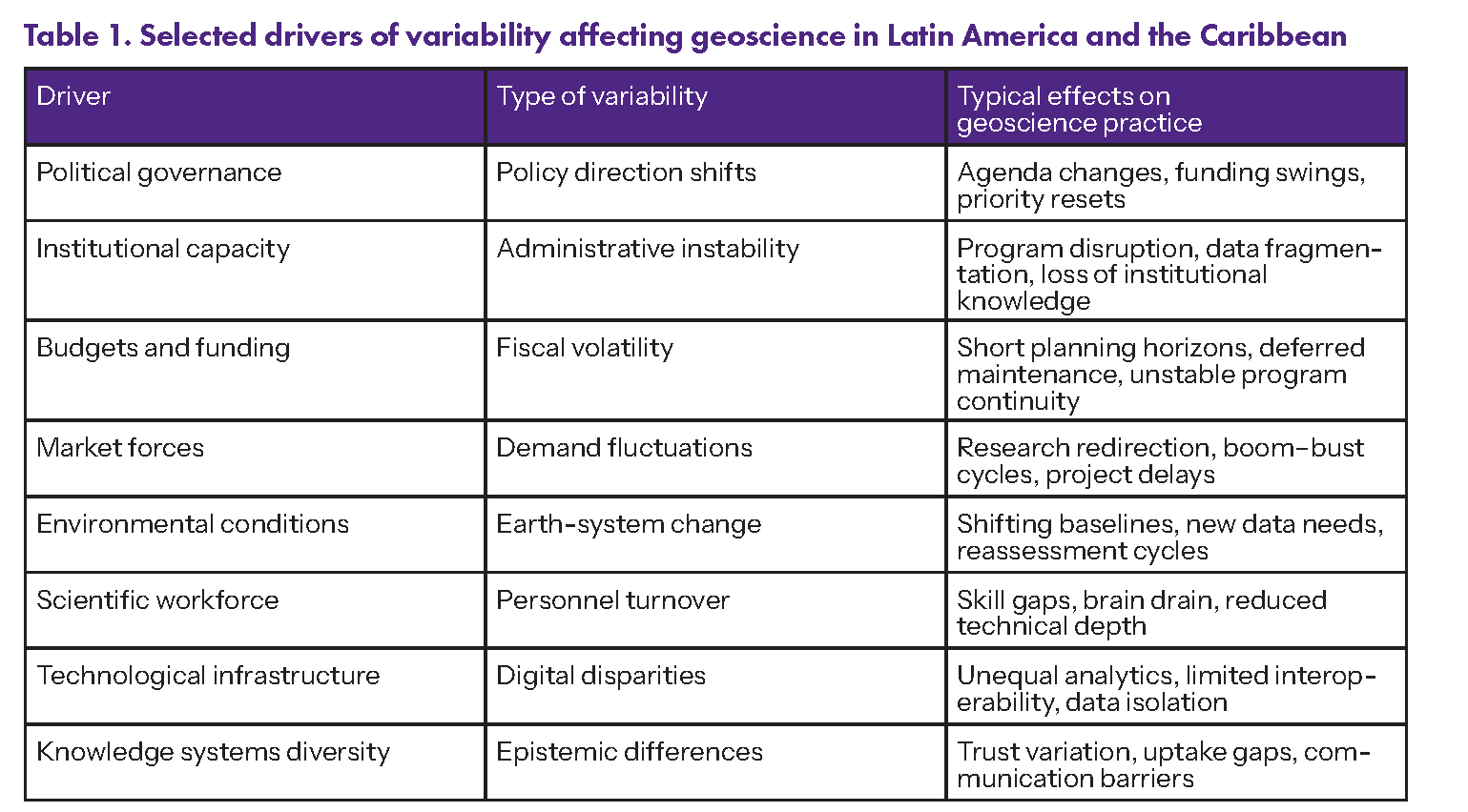
Geoscience in LAC operates within a complex web of interconnected drivers that shape—and sometimes limit—scientific practice. These drivers account for much of the variability observed across the region, manifesting differently among countries and over time as socioeconomic conditions, regulatory settings, and national priorities evolve. The following subsections briefly explore how these conditions affect the capacity for geoscience activity to generate knowledge, influence policy, and advance sustainable development. Table 1 summarizes the key drivers, the types of variability they introduce, and their main implications for geoscientific work.
Table 1
Political Governance and Ideological Pressures
Shifts in political leadership and ideology, driven by electoral cycles and evolving development visions, introduce significant variability into geoscience priorities in LAC. Because public geoscience agencies typically operate under ministerial or executive authority, leadership transitions frequently alter their research directives, funding allocations, and institutional mandates. As a result, the focus of geoscience programs may pivot among priorities such as resource exploration, environmental oversight, climate adaptation, or related objectives. A clear illustration of this dynamic is the politicization of global change debates, which affects support for geohazard monitoring and climate research, as some administrations expand these programs while others curtail them (Ryan, 2017).
To provide another concrete example of political variability, resource extraction strategies can rapidly redirect funding and organizational focus within geoscience. As LAC assumes a larger role in supplying resources for the energy transition and advanced technologies, governments often prioritize policies that increase production and export of these critical minerals. When resource extraction becomes a central policy goal, changes in investment patterns, regulatory frameworks, and institutional mandates typically follow. Research agendas are frequently adjusted to meet immediate strategic needs. Such changes can undermine long-term scientific continuity and expose geoscientific programs to the pressures of short-term political and economic demands (Li et al., 2025).
Institutional and Administrative Capacity
The stability of the geoscientific enterprise in LAC depends heavily on administrative continuity and institutional capacity. Durable mandates, the retention of technical expertise, and long planning horizons support stable programs, yet leadership turnover, ministerial realignments, and shifting policy priorities frequently interrupt programs, fragment data systems, and erode organizational memory. When governance conditions fluctuate, maintaining baselines for resource assessment, environmental regulation, and hazard preparedness becomes difficult.
Regional empirical studies document these constraints. Analyses of environmental governance in El Salvador (World Bank, 2006) and climate policy coordination in Mexico (Valenzuela, 2014) identified overlapping mandates and weak coordination that obstruct data sharing and long-term monitoring. A regional assessment similarly finds science and innovation systems to be uneven and structurally fragile, with short planning horizons frequently linked to administrative turnover (ECLAC, 2023). Under such conditions, institutional instability affects not only the direction of geoscientific activity but also the reliability of its outputs.
Budgets and Funding Structures
Chronic underfunding constrains the ability of geoscience institutions in LAC to sustain core programs. Many agencies depend on unstable combinations of government allocations, project grants, or extractive sector revenues; consequently, some must rely on short-term funding even for routine operations. Fragmented funding disrupts program continuity and undermines long-term functions such as monitoring, laboratory maintenance, and systematic mapping that require consistent multi-year investment.
Examples from both emergency monitoring and routine operational settings illustrate these constraints. In emergency monitoring systems, the University of the West Indies Seismic Research Center (UWI-SRC) relies on inconsistent contributions from its nine member territories, which provide minimal operational capacity and leave research and network upgrades dependent on external funding (UWI-SRC, 2023). In routine operational settings, a World Bank assessment of Peru’s mining sector found that irregular financing and limited capacity restrict laboratory modernization, environmental monitoring, and the application of geoscientific information to resource governance (World Bank, 2021a). Budget volatility therefore affects not only the scale of geoscientific activity but also its long-term continuity and reliability.
Market Forces and Private Sector Influence
Primary sector activities play a central role in many LAC economies and strongly influence geoscientific priorities. Mining, hydrocarbons, and large-scale agriculture generate significant government revenue and often orient research and technical capacity toward resource assessment, territorial analysis, and environmental evaluation (ECLAC, 2023). These sectors channel investment into geological mapping, data infrastructure, and applied research, yet also expose geoscience to market volatility.
Commercial actors both expand technical capacity and introduce vulnerability. For example, regulatory reforms in several resource-rich countries whose economies are strongly influenced by extractive natural-resource endowments have attracted investment in critical minerals and facilitated partnerships among geological surveys, universities, and industry that accelerate the adoption of tools such as remote sensing, subsurface imaging, and artificial intelligence (AI; OECD, 2022; Andrián et al., 2023; Valencia et al., 2025). These partnerships advance innovation, particularly where public funding is limited, but often align research agendas and priorities with market demand. When interest in specific commodities such as lithium, copper, or nickel weakens or declines, support recedes just as quickly, interrupting monitoring programs, research continuity, and infrastructure maintenance (Andrián et al., 2023). Recent surges in demand for energy-transition minerals illustrate both dynamics, expanding geoscientific activity in some contexts while leaving it highly sensitive to fluctuations in global commodity markets in others (Valencia et al., 2025).
Environmental Conditions and Energy Transition
Environmental and energy conditions heighten demands on geoscience in LAC as scientific knowledge increasingly informs regulation, participation, and resource governance. Regional frameworks such as the 2018 Escazú Agreement formalize requirements for transparency and access to environmental information, placing geoscientific data on geohazards, resources, and impacts within public review and decision-making (Dávila, 2023). These mandates expand geoscience responsibilities by linking analysis directly to policy decisions and societal oversight.
Environmental change further intensifies these technical demands. The Intergovernmental Panel on Climate Change (IPCC) identifies major risks, including heat stress, water scarcity, glacier retreat, and intensifying hydrometeorological extremes, that affect energy systems, agriculture, urban settlements, and infrastructure (IPCC, 2022). Because these pressures unfold unevenly across landscapes and sectors, they alter baseline conditions and require updated observations, projections, and assessments for adaptation and risk management. Environmental variability therefore imposes a constraint distinct from political, institutional, or fiscal instability. It originates in Earth systems rather than governance systems and cannot be controlled through administrative action. Geoscience in LAC must consequently sustain continuity while responding to changing physical conditions.
Scientific Workforce Capacity
The availability, stability, and distribution of qualified scientific personnel constrain geoscientific activity in LAC. Since the early 2000s, the region’s share of global research and development (R&D) expenditure has declined from ~3% to 2%, while regional investment in R&D averages ~0.6% of gross domestic product—well below the 2–3% benchmark typical of leading scientific economies (Schneegans et al., 2021; ECLAC, 2023). This limited and inconsistent R&D investment constrains agencies’ ability to retain expertise and maintain long-term scientific programs.
In 2018, LAC accounted for roughly 8% of the world’s population but only ~3.5% of the global research workforce, concentrated largely in a handful of countries (Schneegans et al., 2021). Scientific activity is funded predominantly through public channels and concentrated in universities and research institutes rather than mission-oriented agencies, which can misalign research agendas with national needs (ECLAC, 2023; Maloney et al., 2025). Regional analyses also document persistent shortages of science, technology, engineering, and mathematics (STEM) graduates, high emigration rates among trained scientists (brain drain), and career paths shaped by short-term contracts and piecemeal support (Ciocca and Delgado, 2017; Bonilla, 2024; Maloney et al., 2025). These conditions limit not only how much geoscience can be conducted, but also whether expertise can develop, accumulate, and persist over time.
Technological Infrastructure and Data Capability
Technological capacity for geoscience across LAC remains uneven, revealing asymmetries in digital infrastructure, data governance, and analytical tools. Chavarry Galvez and Revinova (2025) classify LAC countries into three digital development groups: a leading group (Brazil, Mexico, Chile, Colombia, Argentina), an intermediate group (Peru, Uruguay, Costa Rica, Paraguay, Panama, Dominican Republic), and a slower-progress group (Bolivia, Ecuador, Venezuela, Guatemala, El Salvador, Honduras, Cuba, Nicaragua). Caribbean countries face similar constraints (ECLAC, 2023), including limited connectivity, weak information integration, and under-resourced technical environments that hinder participation in international research networks and open geoscience data initiatives such as OneGeology (Jackson, 2008) and the Global Earth Observation System of Systems (GEO, 2015).
These disparities have less to do with a lack of individual technologies than with gaps in digital public infrastructure, data interoperability standards, and organizational capacity to integrate data across platforms (Chavarry Galvez and Revinova, 2025). Some countries now operate integrated geospatial platforms and cloud-based services, such as Peru’s GeoCatMIN system (INGEMMET, 2010) and Chilean applications of AI in mineral analysis (Silva et al., 2023), but many still struggle with basic data integration and system maintenance. Regional analyses likewise show that geoportals often prioritize visualization over reuse, interoperability, and open licensing, which limits their effectiveness as shared scientific infrastructure (Ballari et al., 2025). As a result, technological disparities widen analytical gaps among countries, making the integration, comparison, and reuse of geoscientific data across institutions and borders more difficult.
Knowledge Systems Diversity and Epistemic Inclusion
Indigenous peoples in LAC number roughly 43–58 million, or ~8–10% of the region’s population. Their territories cover more than one-fifth of the land area (RRI, 2023; Davis-Castro, 2025). While large populations in Mexico, Guatemala, Peru, and Bolivia make up most of this total, Indigenous communities are also present throughout the region. Caribbean states, for example, have regional initiatives that document unique knowledge traditions and environmental practices (UNESCO, 2020). Despite extensive geoscientific research in LAC, scientific information often fails to reach these communities in a usable form. In many cases, research does not systematically include Indigenous traditional knowledge. This limits the practical relevance of geoscience where environmental decisions directly impact local livelihoods and resource management (World Bank, 2015).
Studies across environmental and Earth-system fields show that Indigenous and local knowledge systems frequently provide detailed observations of hazards, hydrological behavior, soils, and ecological change derived from long-term interaction with specific landscapes across continental and Caribbean settings (UNESCO, 2020; Zent, 2025). Empirical syntheses further show that initiatives recognizing Indigenous communities as partners rather than just recipients produce more effective and equitable environmental outcomes than externally designed interventions (Dawson et al., 2021). Integrating distinct knowledge traditions requires deliberate methodological design because combining different epistemologies is inherently complex and context-dependent (Raymond et al., 2010). If differences among knowledge systems are overlooked, variation in epistemic frameworks can directly influence whether geoscientific information is trusted, adopted, and sustained across diverse social settings.
Attributes of a Resilient Geoscience Enterprise in Latin America and the Caribbean
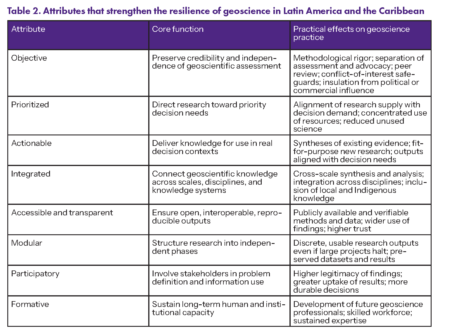
The preceding section examined multiple drivers of variability affecting the context in which the geoscience enterprise operates across LAC. To enhance the resilience of this enterprise, it is essential to incorporate attributes that provide focus, address diverse societal and environmental needs, and sustain geoscientific work under changing conditions. The following subsections identify a set of attributes that reinforce geoscience resilience while enhancing its continuity, technical quality, and public value. These attributes draw on regional experience and practice and serve as guidance for those who design, direct, fund, and evaluate geoscience programs. Table 2 summarizes these attributes, their core functions, and their practical implications for geoscience practice.
Table 2
Objective
In geoscience, objectivity depends on methodological rigor and institutional independence in the generation, interpretation, and use of evidence. In many cases, the same public bodies undertake geoscientific work and oversee resource licensing and extraction, so maintaining separation between assessment and advocacy is essential for sustaining public trust and maintaining science as a reliable basis for decision-making. Scientists play a legitimate role in informing policy by providing rigorous, evidence-based information, yet when they advocate specific outcomes—or are perceived as doing so—they risk conflating scientific credibility with value-laden stances (Lackey, 2007). The challenge is not to separate science from public relevance but to preserve the conditions under which it remains credible and socially legitimate within political contexts.
Policy-relevant geoscience operates most effectively when credibility (scientific soundness), salience (relevance to decision contexts), and legitimacy (perceived procedural fairness) are jointly maintained (Cash et al., 2003). Preserving these qualities demands institutional protections that shield scientific work from undue influence while keeping it responsive to public needs (OECD, 2017). Evaluation frameworks that codify scientific standards, peer review, and conflict-of-interest rules—such as those used by Chile’s National Research and Development Agency (ANID)—align research practice from proposal through project implementation with explicit standards of rigor, impartiality, and accountability (ANID, 2025).
Insulating expert assessment from political authority and dominant funding sources strengthens the reliability and credibility of scientific advice (OECD, 2017). Brazil’s National Council for Scientific and Technological Development (CNPq) offers a concrete example: integrity and ethics programs, including prevention protocols, training, oversight bodies, and audits, discourage misconduct and limit conflicts of interest and external influence on research (CNPq, 2021). These arrangements show how independent geoscientific assessment can be maintained while still informing consequential decisions.
Objectivity, therefore, requires disciplined practice by individual researchers and robust organizational safeguards capable of sustaining it across changing political and economic contexts. Upholding it demands not only ethical standards, accountability mechanisms, and communication practices, but also ongoing vigilance to shield geoscience from political, commercial, or ideological capture. By maintaining these protections, geoscience remains relevant to urgent social and environmental decisions, ensuring that scientific evidence continues to inform public policy and resource management (Cash et al., 2003; OECD, 2017).
Prioritized
This attribute directs limited scientific and fiscal resources toward the most urgent and societally relevant challenges. Effective prioritization begins with decision makers. These actors, including elected officials, regulatory authorities, and other legitimate decision makers, define the decision contexts for which scientific input is needed (Bisbal and Eaton, 2023). Once priorities are articulated, publicly funded geoscience organizations can identify the most useful research questions and design research to inform them. The distinction between demand for scientific information (set by policy authorities) and supply of scientific information (provided by research institutions) is critical. When the supply of geoscientific information responds to demand, research is targeted, timely, and useful; when it proceeds without clearly articulated decision contexts, even high-quality work risks remaining unused (McNie, 2007).
When research agendas explicitly align with decision contexts, resources can be concentrated where they yield the greatest societal benefit. Effective science-policy interfaces depend on aligning scientific information with decision makers’ operating routines (McNie, 2007). Such alignment requires research portfolios structured around defined decision contexts, feasible timelines, and deliverables that directly serve policy needs. Structured collaboration and iterative feedback between research organizations and policy authorities turn demand-driven priorities into usable research outcomes (Bisbal and Eaton, 2023). Furley et al. (2018) document this across LAC, showing that participatory workshops between scientists, regulators, and civil-society actors helped identify regional environmental research priorities and enhanced alignment between science and management.
Weak or absent prioritization exposes the costs of unarticulated decision contexts. Donadelli (2020) describes Brazilian environmental policy case studies in which robust scientific evidence was available and communicated to policymakers yet had little impact because it did not fit decision routines. Forestry studies formally requested by national legislators were ultimately disregarded during negotiations, and pesticide risk assessments did not help shape regulatory decisions. These examples illustrate how science can be produced—and even formally solicited—without a corresponding demand embedded in decision rules or accountability mechanisms. Valuable knowledge then remains disconnected from the decisions it was meant to inform. Measuring such “unused” or “orphaned” science is difficult because it requires demonstrating that a decision process existed, that relevant scientific outputs were available, and that they were not taken up. This pattern of disconnection, however, is recurrent and costly (McNie, 2007).
Three simple operational protocols can reduce this inefficiency: (1) public statements of decision points and deadlines; (2) joint scoping to clarify what information is needed, in what format, and by when; and (3) periodic progress reviews. Implementing these practices requires deliberate coordination among scientists and decision makers, thereby putting into practice Bisbal and Eaton’s (2023) conditions: legitimate decision makers declare the decisions of interest, and science needs are identified through structured needs assessments or gap analyses. They also provide the transparent prioritization methods described by Carter et al. (2025). Linking research agendas to formal policy frameworks, such as national development strategies, climate adaptation plans, or resource-management programs, improves accountability, visibility, and funding alignment, making scientific initiatives more attractive to domestic and international funders. Clear prioritization turns scientific investment into a predictable public good that informs decisions and advances societal well-being.
Actionable
This attribute operates in two complementary senses, encompassing both synthesized existing evidence and newly generated research. In both cases, knowledge is actionable when it is organized or produced to inform concrete decisions and interventions. In a broad sense, actionable science refers to existing scientific information synthesized through peer-reviewed systematic reviews, meta-analyses, or other structured evidence assessments (Haddaway et al., 2018). These syntheses provide decision makers with reliable, consensus-based findings without commissioning new studies. Thus, actionable geoscience includes studies whose combined insights directly inform decisions on issues such as groundwater management, resource assessment, or hazard mitigation (Dilling and Lemos, 2011; Mach et al., 2020).
More narrowly, actionable science also encompasses new research purposefully designed to address clearly defined decision contexts. In these cases, potential users actively participate from the beginning, helping to identify key questions, desired outcomes, and preferred formats (Dilling and Lemos, 2011; Palmer, 2012; Mach et al., 2020). This ensures the resulting science is truly fit for purpose. Ongoing dialogue between knowledge producers and users keeps information timely, relevant, and usable in real policy settings, regardless of whether it is considered basic or applied research (Dilling and Lemos, 2011; Mach et al., 2020). By aligning research with concrete policy or management challenges articulated in advance by legitimate decision makers, this approach produces science that directly meets practical needs, such as early-warning systems for natural hazards tailored to local requirements (Cash et al., 2003; Bisbal and Eaton, 2023).
The usability of scientific knowledge depends more on how well it aligns with decision-making processes than on whether it originates from fundamental research or practical application (Dilling and Lemos, 2011). Actionable geoscience relies on boundary-spanning mechanisms—such as advisory committees, science agendas, and joint workshops—that foster ongoing dialogue between researchers and policy institutions without requiring the commitment of full co-production (Dilling and Lemos, 2011; Cvitanovic et al., 2015; Mach et al., 2020). This two-way exchange ensures that research outcomes are not simply handed off but are collaboratively developed with those responsible for putting decisions into practice.
Aligning research with defined decision contexts channels scientific effort toward governance needs rather than generic information gaps (McNie, 2007; Dilling and Lemos, 2011). Decision-making contexts provide a direct motivation for scientific activity, legitimizing investment when budgets are constrained and societal needs intensify (Bisbal and Eaton, 2023). By targeting specific, pre-identified decisions, actionable science reduces wasted resources and increases the value of public investment (Dilling and Lemos, 2011; Bisbal, 2019). This approach shifts science from hoping that research will someday be used to ensuring that decision makers anticipate it as essential input. By linking scientific rigor to practical needs through arrangements that foster feedback, transparency, and shared ownership, actionable geoscience provides reliable input for publicly funded decisions.
Integrated
Integration in geoscience extends beyond interdisciplinary collaboration (Stock and Burton, 2011). It is a multiscale synthesis that connects knowledge, data, and perspectives across spatial scales (from local observations to global models) and temporal scales (from real-time monitoring to geological and paleoclimatic reconstructions; Bierkens, 2015). Understanding Earth processes requires this integrative approach because climatic, tectonic, hydrological, and ecological systems interact across scales. Hazard assessments, for example, depend on combining fine-scale geomorphological mapping with regional tectonic frameworks and climate projections, while groundwater and mineral resource management require coupling localized measurements with basin-scale and transboundary analyses. This approach yields knowledge that is context-specific and regionally coherent, thereby increasing its utility for planning and cooperation (Capello et al., 2023; Stewart et al., 2023).
Integration also links scientific analysis with diverse knowledge systems and institutional settings. Local observations often complement scientific data sets and enhance interpretation (Raymond et al., 2010). Indigenous knowledge, refined through long-term engagement with specific environments, extends observational detail and improves hazard awareness and environmental assessment; however, meaningful integration requires attention to power asymmetries and epistemic equity (Ijatuyi et al., 2025). Governance arrangements recognizing Indigenous tenure and authority have been shown to support biodiversity and well-being more consistently than externally imposed management approaches (Dawson et al., 2021). Field experience illustrates how these complementarities operate. Monitoring networks around Tungurahua volcano in Ecuador combine community observations of lahars with instrumental geophysical data to generate real-time warnings that have saved lives during eruptions (Stone et al., 2014). In Colombia, collaborative research on the Doña Juana Volcano–Páramo system integrates geoscientific, social scientific, and community knowledge to support locally led risk-reduction strategies (Pardo et al., 2021). Such cases show that integration improves geoscientific analysis when it connects data sets, disciplines, and ways of knowing (Stock and Burton, 2011).
Earth-system science grounds this integrative approach by treating the atmosphere, hydrosphere, biosphere, and lithosphere as interacting components of a dynamic whole influenced by human activity (Steffen et al., 2020). For societies whose economies and livelihoods rely directly on natural systems, this perspective clarifies how land use, extraction, and environmental change interact across scales to influence stability and vulnerability. Integration, therefore, is not just an analytical preference but a practical requirement for producing knowledge that informs coordinated environmental governance and sustainable development.
Accessible and Transparent
Openness and transparency are fundamental to the credibility, reproducibility, and public value of geoscience in LAC. Uneven data access across the region makes firm commitments to open science principles necessary. The World Bank (2021b) documents infrastructure gaps, including insufficient domestic data centers, that constrain environmental monitoring in many low- and middle-income countries. Open geoscientific information accelerates research progress, strengthens public trust, and supports evidence-based decisions on hazard mitigation, water management, and mineral resource governance.
The FAIR data principles (Findable, Accessible, Interoperable, and Reusable) keep scientific outputs usable across disciplines, institutions, and national boundaries (Wilkinson et al., 2016). Applying these standards to data sets such as maps, geochemical records, seismic data, or satellite imagery supports preservation, discoverability, and integration into regional and global information systems. At the regional scale, the Group on Earth Observations for Latin America and the Caribbean (GEO-LAC) promotes open access to Earth observation data and tools, linking national repositories to platforms such as the Global Earth Observation System of Systems (GEOSS; GEO, 2015).
As open data policies expand, national geological surveys have adopted practices that implement these principles (Palma Peña, 2023). Brazil’s Geological Survey (SGB) expanded digital access through its GeoSGB platform, integrating geochemical, geological, and geophysical data sets under open data standards (SGB, n.d.). Argentina’s Geological Mining Survey (SEGEMAR) developed SIGAM, a geo-environmental mining information system providing geological maps and metadata aligned with regional interoperability standards (Ferpozzi et al., 2025). Likewise, Mexico’s Geological Service (SGM) expanded digital mapping through GeoInfoMex, which provides direct access to geological and mineral data (SGM, 2025). These initiatives show how transparent data practices increase the reach and societal value of publicly funded research.
Open science requires coordination among funders, libraries, repositories, and agencies, as well as disclosure of project goals, methods, funding sources, and peer-review procedures (OECD, 2015; UNESCO, 2021). These practices operate in national systems such as Peru’s Open Access to Scientific Information for Innovation (ALICIA) repository network (República del Perú, 2013) and Chile’s ANID open-access policy (Roa, 2023), reflecting broader regional trends. These approaches can increase article citation rates and reduce research duplication, strengthening the case for investment in interoperable data systems (OECD, 2015). When openness is embedded through policy mandates, training, and sustained infrastructure investment, the LAC geoscience community can ensure that data and knowledge remain public goods that support credibility, collaboration, innovation, and evidence-based decisions across the region (Palma Peña, 2023).
Modular
The path to sustainable development and economic growth in LAC has heightened demand for investment in transportation, energy, mining, urban development, and water and sanitation infrastructure (Fay et al., 2017; Brichetti et al., 2021). Many of these initiatives take the form of ambitious large-scale projects. Such projects depend on early assessment of geological, geotechnical, and hydrogeological conditions, as illustrated by canal stability studies in Panama (Waltham, 2020), pre-construction studies for the Coca Codo Sinclair hydroelectric project in Ecuador (Barrera Crespo et al., 2024), and corridor design and hazard assessments along the Capricorn Bioceanic Corridor across Brazil, Paraguay, Argentina, and Chile (Scholvin et al., 2024; van Marrewijk, 2026).
Evidence shows that many infrastructure initiatives in LAC face political or social opposition that can lead to delay, redesign, or cancellation (Watkins et al., 2017). When projects derail because of conflict, associated geoscientific work can become collateral damage; geoscientific outputs may remain in gray literature and proprietary archives without integration into national repositories or long-term monitoring programs. This pattern is evident in the Panama Canal expansion planning and controversial reservoir proposals in its western watershed (Gonzalez, 2008), as well as the Coca Codo Sinclair project, where fluvial erosion and slope instabilities underscored the need for sustained monitoring beyond single-phase project studies (Barrera Crespo et al., 2024).
Modular organization of geoscience work can mitigate infrastructure risk by breaking large projects into self-contained phases, each with publicly usable outputs. Rather than treating data collection, modeling, and monitoring as a single package whose value depends on full project completion, modular approaches can specify discrete phases funded, delivered, and evaluated independently. In the geotechnical characterization across the Panama Canal system, for example, this structure could have helped ensure that geotechnical and slope-stability information generated for specific initiatives was preserved and positioned for broader groundwater, landslide, and infrastructure governance beyond individual project cycles (Waltham, 2020). Programs such as the UNESCO–IUGS International Geoscience Program (IGCP), which supports geoscience projects that deliver maps, data sets, and training within limited 3–5-year phases, show how time-bound, phased designs can institutionalize this logic and promote dissemination (Heirman and Adiyaman Lopes, 2019).
Modularity can strengthen cross-scale geoscientific work in complex transnational megaprojects like the Capricorn Bioceanic Corridor, where decisions span Brazil, Paraguay, Argentina, and Chile (Scholvin et al., 2024; van Marrewijk, 2026). By designing hazard, groundwater, and geomorphological studies as independent phases within each country, researchers can produce results that are meaningful locally and contribute to broader corridor-scale assessments. This approach reduces the risk that cross-border institutional deadlock or changes in national priorities will leave valuable scientific work inaccessible or unused (Scholvin et al., 2024). In this way, modular research reorients geoscientific ambition in LAC toward resilient practice. It ensures that scientific investment produces enduring, accessible public goods, regardless of the fate of individual infrastructure ventures.
Participatory
Participation is a cornerstone of legitimate and impactful geoscience in LAC because it helps bridge the historical divide between scientific institutions and societal needs (Vessuri, 2003). In the twentieth century, much scientific work took place within universities and research institutes, removed from productive sectors and daily life. These efforts often prioritized technical solutions and external agendas over local citizens’ everyday concerns (Vessuri, 2003). If these patterns persist, geological surveys and related agencies risk producing technically sound outputs detached from pressing water, land, and resource questions affecting farmers, urban neighborhoods, or Indigenous and other ethnic communities. Experiments with “participatory” groundwater management in Mexico, for example, show that consultative fora can remain symbolic rather than substantive when public agencies retain control over key decisions and fail to address structural socioeconomic disparities. This evidence shows that participation must be embedded in decision-making to sustain trust (World Bank, 2015; Hoogesteger and Wester, 2017; Vela-Almeida et al., 2022).
Participatory geoscience reduces institutional and social distance by creating collaborative spaces (such as joint committees, listening workshops, or public fora) where scientists, officials, and community actors identify problems, agree on methods, and define decision-relevant outputs (Sankatsing Nava and Hofman, 2018; Lee et al., 2020). Combining scientific analysis with local lived experience or traditional practices produces findings more likely to be understood, trusted, and used by affected communities. This alignment increases the relevance and resilience of the resulting science (Vela-Almeida et al., 2022).
Participatory efforts in geoscience and risk management in LAC generally fall into two main modalities (Lee et al., 2020; Vela-Almeida et al., 2022). The first centers on citizen science, where volunteers contribute observations or measurements to expert-led projects (Marchezini et al., 2017). These initiatives, often launched by universities, NGOs, or civil protection agencies, rely on geological surveys and other public institutions to incorporate these data into official monitoring and natural-hazards programs (Kirschke et al., 2023). Participatory early-warning programs in Brazil illustrate this model: students and teachers contribute observations that agencies integrate with scientific monitoring to improve flood and landslide warnings in vulnerable communities (Marchezini et al., 2017).
The second modality focuses on community-based disaster risk management and environmental monitoring, where residents, local officials, and sometimes companies collaborate on project decisions—what to measure, why it matters, how to interpret results, and how findings are applied in preparedness or regulation (Pareja et al., 2019; Thongs and Griffith, 2020). In Trinidad’s Sangre Grande, community risk assessments bring residents and disaster managers together to identify hazards and vulnerabilities to improve preparedness and response (Thongs and Griffith, 2020). In mining regions of Argentina, Bolivia, Panama, and Peru, participatory environmental monitoring committees unite communities, companies, and agencies to oversee water quality, prioritize concerns, and build relationships (Pareja et al., 2019). These cases show that participatory initiatives influence outcomes most effectively when collaboratively generated knowledge is built into formal land, water, and resource governance, rather than limited to data collection alone.
Formative
The formative attribute in geoscience prepares the next generation of scientists, technicians, teachers, and decision-makers who will sustain and advance the field. Formative capacity is vital for resilience because it keeps expertise current for new challenges, technologies, and societal needs (Levine et al., 2007; Metzger, 2024). In LAC, formative geoscience secures earth science expertise in careers, institutions, and communities, supporting the discipline’s continuity (UNESCO, 2019; Villacorta et al., 2024).
Formative geoscience begins with earth science education in primary and secondary classrooms. LAC trails in partnerships among schools, scientists, companies, and geoparks, and in forming amateur geoscience networks (UNESCO, 2019). Programs that prepare teachers to educate students and engage local actors are essential. For example, climate change education initiatives in Mexico and Chile use inquiry-based teaching, local case studies, and hybrid training to enable thousands of teachers to teach climate and Earth systems. These programs also enable schools to influence community practices (Reyes et al., 2025). At the tertiary level, formative geoscience integrated disciplinary expertise along with ethics, social responsibility, and engagement across science–society boundaries. Integrating geoethics into university curricula in Peru, Chile, Mexico, Argentina, and Cuba prepares future geoscientists to tackle mining conflicts, water security, and hazard governance, using active learning and culturally relevant approaches (Villacorta et al., 2024). Further efforts align academic degrees with the UN 2030 Sustainable Development Goals and embed geoethics, diversity, and inclusion as core competencies for addressing socioenvironmental challenges (Capello et al., 2023; Metzger, 2024).
Formative capacity also depends on how students progress along the geoscience pathway. Essential elements include engaging fieldwork, mentoring, and support at key transitions from school to university, graduate study, and employment (Levine et al., 2007; Riggs and Alexander, 2007). The Geoscience Education Field Officer network, managed by the IUGS Commission on Geoscience Education (COGE) in non-European countries and now working with the Geosciences Center at the National Autonomous University of Mexico (UNAM), shows how trained educators expand earth science teaching where curricula are limited (Clark et al., 2024). They do so through open-access resources and international partnerships to sustain student interest. Efforts like “geoscience ambassadors” help students define career paths and see themselves as scientists and leaders in the field (Metzger, 2024; Ellins et al., 2025). These initiatives foster retention by offering mentorship, guidance, and professional development for diverse early career professionals. Increasingly, these pathways also incorporate professionals from related disciplines (e.g., environmental science, engineering, data science, social science) whose expertise complements geoscientific analysis and strengthens work at the interface of natural systems and societal decision-making (Stock and Burton, 2011).
Regional and international cooperation reinforces formative capacity. Since 1972, the International Geoscience Program (IGCP) has funded thousands of projects and trained scientists from developing countries through field schools, workshops, and mobility grants (Heirman and Adiyaman Lopes, 2019). In LAC, networks like the Association of Iberoamerican Geological and Mining Surveys (ASGMI, www.asgmi.org) and the Inter-American Network of Academies of Sciences (IANAS, www.ianas.org) connect geological surveys and academic institutions across nations through joint mapping initiatives and mentoring to build professional communities and maintain technical capacity. When capacity building rests on stable institutional arrangements, rather than temporary project outcomes, the region’s geoscience workforce retains authority and effectiveness even during fiscal and political uncertainty (UNESCO, 2019; Villacorta et al., 2024).
Linking Drivers of Variability and Attributes of the Geoscience Enterprise
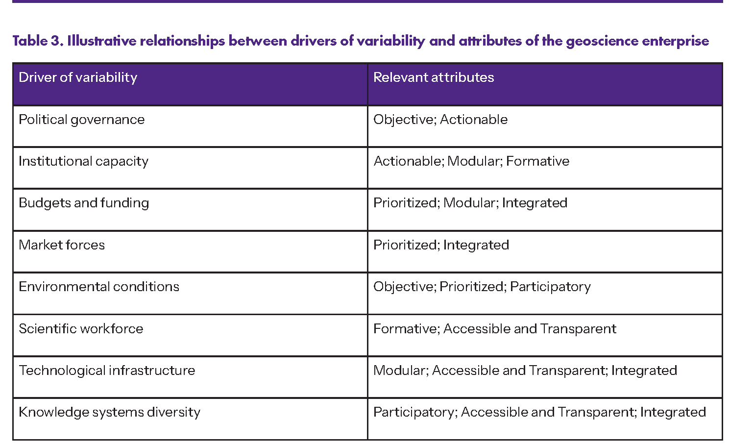
Earlier sections developed two strands of the analysis: the sources of variability that shape the conditions under which geoscience operates in Latin America and the Caribbean (Table 1), and the attributes that allow the geoscience enterprise to maintain resilience under those conditions (Table 2). Examining these strands side by side allows a closer look at how specific attributes become crucial as operating environments change. Table 3 explores these relationships by directly juxtaposing the drivers of variability with the attributes of geoscientific practice described earlier.
Certain attributes are associated with particular sources of variability because they help address the types of disruption those sources introduce. For example, variability introduced by political change may redirect research agendas, alter institutional mandates, or place pressure on the independence of scientific assessment. In these circumstances, maintaining objectivity helps preserve the credibility of scientific analysis, while actionable science helps ensure that research remains connected to identifiable decision contexts despite shifting political priorities. These associations reflect judgments grounded in the earlier discussion of how different attributes contribute to the resilience of the geoscience enterprise.
Several attributes may bolster resilience in response to more than one source of variability. Modular design provides a clear example. When geoscientific projects are organized in discrete, self-contained phases that yield usable outputs, valuable knowledge persists even if the broader initiative stalls. This approach sustains geoscientific work under diverse forms of instability. For instance, in contexts where institutional capacity is inconsistent, modular organization enables scientific work to continue delivering results despite administrative turnover or shifting mandates. Under unstable funding, phased designs make it possible to complete and share meaningful outputs even if resources fall short of supporting an entire program. In cases where technological infrastructure evolves unevenly, modular strategies allow for the incremental creation of data sets, analytical tools, and monitoring systems, rather than relying on the immediate availability of full technical capacity. The recurrence of certain attributes reflects their practical effectiveness in limiting disruptions from multiple sources of variability that threaten the continuity and impact of the geoscience enterprise under changing conditions.
The relationships shown in Table 3 should therefore be understood as a first approximation rather than a universal template. The extent to which any attribute contributes to resilience depends on the specific circumstances in which geoscientific work takes place. In some countries certain attributes may be strongly developed—for example, through sustained investment in training programs, open data infrastructures, or collaborative research networks—allowing them to buffer several forms of variability at once. In other settings those same attributes may be only partially developed or absent, leaving the geoscience enterprise more exposed to instability. Rather than serving as a prescriptive checklist, Table 3 invites reflection on how different attributes of the geoscience enterprise can be strategically leveraged or combined to strengthen resilience where stability cannot be assumed.
Table 3
Conclusion
The geoscience enterprise in Latin America and the Caribbean operates under persistent variability rather than stable conditions. In such dynamic conditions, resilience depends on both technical expertise and how geoscience is practiced. Leadership and thoughtful professional choices determine whether scientific work remains credible, relevant, and sustainable as circumstances evolve. Decisions about how geoscience is organized, evaluated, communicated, and sustained play a crucial role in determining whether the enterprise can adapt and persist amid instability. Resilience must be strategically designed, not automatically assumed.
The attributes identified in this paper reveal how the geoscience enterprise can be structured to remain resilient. Qualities such as objectivity, prioritization, actionability, integration, openness, modularity, participation, and formative capacity may appear as abstract ideals. The analysis presented here invites a different interpretation: their practical role as safeguards that allow scientific work to continue even as circumstances change. By reducing dependence on stable conditions, these attributes help preserve continuity and anchor geoscientific practice in adaptable approaches. When incorporated into program design and daily professional routines, they enable geoscience to retain coherence and relevance to society over time. These attributes, however, are not static. Their effectiveness depends not only on their selection but on continuous renewal through ongoing attention and adaptation to changing circumstances.
This discussion also makes clear that these attributes should not be interpreted as requirements for simultaneous implementation. No institution can integrate all of them at once, and additional attributes beyond those discussed here may prove important in particular contexts. What matters is strategic consideration of which attributes deserve priority under a given mandate, organizational capacity, and operating environment. In some settings, strengthening one or two areas may make the greatest difference in sustaining scientific work. Adopting a fixed or exhaustive set of attributes is neither necessary nor realistic. Thoughtful judgment about which attributes deserve emphasis in a particular institutional setting remains essential.
Scientific rigor and technical excellence are essential, but their influence is maximized only when paired with attributes that keep geoscientific work relevant to management and policy decisions. Sustaining these attributes over time anchors geoscience in both professional competence and social legitimacy. These two pillars reinforce one another but rarely flourish independently. While professional competence forms the foundation for reliable scientific analysis, the ongoing influence of geoscience depends equally on strong relationships among scientists, decision makers, and affected communities. Active engagement among these actors and joint identification of key decision questions ensures that geoscientific knowledge remains responsive to real-world challenges. Through the thoughtful adoption and cultivation of these attributes, expertise is blended with trust, ultimately transforming geoscience from a technical pursuit into a meaningful force for public good.
Although grounded in Latin American and Caribbean experience, the perspectives presented here are not restricted to this region. The drivers of variability analyzed in this paper characterize many parts of the world. LAC’s experience thus serves as a revealing analytical lens rather than a special case. What LAC illustrates are the challenges and risks posed by persistent instability, where uncertainty and institutional variability are the norm. The region also demonstrates the effectiveness of adaptive strategies that transform these challenges into opportunities for organizational learning and resilience. By distilling lessons from LAC, this paper highlights practical strategies to help geoscience organizations remain resilient and decision-relevant—an imperative for practitioners globally.
Acknowledgments
We are grateful to Vicente Gabaldón for his comments on earlier versions of this manuscript. The authors would like to express their gratitude to Dr. Julio Matteo Bruna Novillo (who consented to be identified) and an anonymous reviewer; their thorough assessments significantly improved the quality of this paper.
References Cited
- Agencia Nacional de Investigación y Desarrollo (ANID), 2025, Guía de evaluación de proyectos de investigación: Fondo Nacional de Desarrollo Científico y Tecnológico Fondecyt, 75 p., https://s3.us-east-1.amazonaws.com/documentos.anid.cl/proyecto-investigacion/postulantes/Guia_de_Evaluacion_de_Proyectos_Investigacion.pdf.
- Andrián, L.G., Balza, L., Chávez, A., Díaz, L.M., Manzano, O., and Valdivia, D., 2023, The Extractive Sector as a Lever for Productive Transformation: Inter-American Development Bank, 95 p., https://doi.org/10.18235/0005125.
- Ballari, D., Siabato, W., Claramunt, C., Mata, F., Zagal, R., and Franco, R., 2025, On the development of open geographical data infrastructures in Latin America: Progress and challenges: Journal of Spatial Information Science, no. 30, p. 3–23, https://doi.org/10.5311/JOSIS.2025.30.364.
- Barrera Crespo, P.D., Espinoza Girón, P., Bedoya, R., Gibson, S., East, A.E., Langendoen, E.J., and Boyd, P., 2024, Major fluvial erosion and a 500-Mt sediment pulse triggered by lava-dam failure, Río Coca, Ecuador: Earth Surface Processes and Landforms, v. 49, p. 1058–1080, https://doi.org/10.1002/esp.5751.
- Berkes, F., Colding, J., and Folke, C., 2000, Rediscovery of Traditional Ecological Knowledge as adaptive management: Ecological Applications:v. 10, p. 1251–1262, https://doi.org/10.1890/1051-0761(2000)010[1251:ROTEKA]2.0.CO;2.
- Bierkens, M.F.P., 2015, Global hydrology 2015: State, trends, and directions: Water Resources Research, v. 51, p. 4923–4947, https://doi.org/10.1002/2015WR017173.
- Bisbal, G.A., 2019, Practical tips to establish an actionable science portfolio for climate adaptation: Science and Public Policy, v. 46, p. 148–153, https://doi.org/10.1093/scipol/scy070.
- Bisbal, G.A., and Eaton, M.J., 2023, Considering science needs to deliver actionable science: Conservation Biology, v. 37, https://doi.org/10.1111/cobi.14013.
- Bonilla, I., 2024, Latin American region facing the brain drain: Global Journal of Human-Social Science, v. 24, p. 31–44, https://doi.org/10.34257/GJHSSHVOL24IS6PG31.
- Brichetti, J.P., Mastronardi, L., Rivas Amiassorho, M.E., Serebrisky, T., and Solís, B., 2021, The infrastructure gap in Latin America and the Caribbean: Investment needed through 2030 to meet the sustainable development goals: Inter-American Development Bank, 77 p., https://doi.org/10.18235/0003759.
- Capello, M.A., et al., 2023, Geoscience in action: Advancing sustainable development: UNESCO and the American Geophysical Union, 87 p., https://unesdoc.unesco.org/ark:/48223/pf0000384826.
- Carter, S.K., et al., 2025, Identifying priority science information needs for managing public lands: Environmental Management, v. 75, p. 444–463, https://doi.org/10.1007/s00267-024-02080-3.
- Cash, D.W., Clark, W.C., Alcock, F., Dickson, N.M., Eckley, N., Guston, D.H., Jäger, J., and Mitchell, R.B., 2003, Knowledge systems for sustainable development: Proceedings of the National Academy of Sciences of the United States of America, v. 100, p. 8086–8091, https://doi.org/10.1073/pnas.1231332100.
- Chavarry Galvez, D.P., and Revinova, S., 2025, Assessing digital technology development in Latin America countries: Challenges, drivers, and future directions: Digital, v. 5, https://doi.org/10.3390/digital5020020.
- Ciocca, D.R., and Delgado, G., 2017, The reality of scientific research in Latin America: An insider’s perspective: Cell Stress and Chaperones, v. 22, p. 847–852, https://doi.org/10.1007/s12192-017-0815-8.
- Clark, I., Villacorta, S., Miller, S., and Occhipinti, S., 2024, The history and current status of IUGS-COGE: Two decades of progress in Global Geoscience Education: Episodes, v. 47, p. 699–708, https://doi.org/10.18814/epiiugs/2024/02404s05.
- Conselho Nacional de Desenvolvimento Científico e Tecnológico (CNPq), 2021, Programa de Integridade do CNPq: CNPq, 28 p., https://www.gov.br/cnpq/pt-br/assuntos/noticias/cnpq-em-acao/copy_of_PlanodeIntegridade_vf.pdf.
- Cvitanovic, C., Hobday, A.J., van Kerkhoff, L., Wilson, S.K., Dobbs, K., and Marshall, N.A., 2015, Improving knowledge exchange among scientists and decision-makers to facilitate the adaptive governance of marine resources: A review of knowledge exchange tools and processes: Ocean & Coastal Management, v. 112, p. 25–35, https://doi.org/10.1016/j.ocecoaman.2015.05.002.
- Dávila, S.A., 2023, The Escazú Agreement: The last piece of the tripartite normative framework in the right to a healthy environment: Stanford Environmental Law Journal, v. 42, p. 63–119, https://law.stanford.edu/wp-content/uploads/2023/02/J_Davila-Escazu-Agreement_web_2-20.pdf.
- Davis-Castro, C.Y., 2025, Indigenous Peoples in Latin America: Statistical information: Congressional Research Service Report R46225, 28 p., https://www.congress.gov/crs-product/R46225.
- Dawson, N.M., et al., 2021, The role of Indigenous peoples and local communities in effective and equitable conservation: Ecology & Society, v. 26, https://doi.org/10.5751/ES-12625-260319.
- Dilling, L., and Lemos, M.C., 2011, Creating usable science: Opportunities and constraints for climate knowledge use and their implications for science policy: Global Environmental Change, v. 21, p. 680–689, https://doi.org/10.1016/j.gloenvcha.2010.11.006.
- Donadelli, F., 2020, When evidence does not matter: The barriers to learning from science in two cases of environmental policy change in Brazil: Science and Public Policy, v. 47, p. 313–321, https://doi.org/10.1093/scipol/scaa006.
- ECLAC (Economic Commission for Latin America and the Caribbean), 2023, Science, technology and innovation: Cooperation, integration and regional challenges: United Nations, 29 p., https://repositorio.cepal.org/server/api/core/bitstreams/82075f44-6962-41fb-b436-c1e2dadd9d49/content.
- Ellins, K.K., Legendre, L.J., Papendieck, A.S., and Clarke, J.A., 2025, Geoscience ambassadors: An extracurricular college-level program for transforming relationships to the geosciences through student-crafted stories: Journal of Geoscience Education, v. 73, p. 117–132, https://doi.org/10.1080/10899995.2024.2328376.
- Fay, M., Andres, L.A., Fox, C., Narloch, U., Straub, S., and Slawson, M., 2017, Rethinking infrastructure in Latin America and the Caribbean: Spending better to achieve more: World Bank Group, 88 p., https://documents1.worldbank.org/curated/en/676711491563967405/pdf/114110-REVISED-Rethinking-Infrastructure-Low-Res.pdf.
- Ferpozzi, F.J., Casanova, M.C., Pereyra, F.X., Buceta, M.G., Tobío, M.I., Olmos, M.I., and Gambandé Alvarez, M.L., 2025, Modelo de datos geomorfológico para la producción de mapas a diferentes escalas en el SIGAM: Servicio Geológico Minero Argentino: Serie Contribuciones sobre SIG e IDE N°45, no. 45, 53 p., https://repositorio.segemar.gov.ar/handle/308849217/4992.
- Furley, T.H., et al., 2018, Toward sustainable environmental quality: Identifying priority research questions for Latin America: Integrated Environmental Assessment and Management, v. 14, p. 344–357, https://doi.org/10.1002/ieam.2023.
- Gonzalez, C.G., 2008, Environmental impact assessment in post-colonial societies: Reflections on the proposed expansion of the Panama Canal: Tennessee Journal of Law and Policy, v. 4, p. 303–354, https://doi.org/10.70658/1940-4131.1132.
- Group on Earth Observations (GEO), 2015, GEO Strategic Plan 2016–2025: Implementing GEOSS: Group on Earth Observations, 31 p., https://online.fliphtml5.com/mvxe/lbeo/.
- Haddaway, N.R., Macura, B., Whaley, P., and Pullin, A.S., 2018, ROSES RepOrting standards for Systematic Evidence Syntheses: Pro forma, flow-diagram and descriptive summary of the plan and conduct of environmental systematic reviews and systematic maps: Environmental Evidence, v. 7, https://doi.org/10.1186/s13750-018-0121-7.
- Heirman, K., and Adiyaman Lopes, O., 2019, The UNESCO–IUGS International Geoscience Programme (IGCP) in the service of society since 1972: Geological Society of London, Special Publication 499, p. 257–265, https://doi.org/10.1144/SP499-2019-73.
- Hill, P.R., Lebel, D., Hitzman, M., Smelror, M., and Thorleifson, H., 2020, The changing role of geological surveys: Introduction: Geological Society of London, Special Publication 499, p. 1–15, https://doi.org/10.1144/SP499-2020-19.
- Hoogesteger, J., and Wester, P., 2017, Regulating groundwater use: The challenges of policy implementation in Guanajuato, Central Mexico: Environmental Science & Policy, v. 77, p. 107–113, https://doi.org/10.1016/j.envsci.2017.08.002.
- Ijatuyi, E.J., Lamm, A., Yessoufou, K., Suinyuy, T., and Patrick, H.O., 2025, Integration of indigenous knowledge with scientific knowledge: A systematic review: Environmental Science & Policy, v. 170, https://doi.org/10.1016/j.envsci.2025.104119.
- Instituto Geológico, Minero y Metalúrgico del Perú (INGEMMET), 2010, Lanzamiento oficial del GEOCATMIN: Revista Institucional INGEMMET, v. 2, p. 6–7, https://repositorio.ingemmet.gob.pe/bitstream/20.500.12544/519/1/Revista_Ingemmet_06-2010.pdf.
- Intergovernmental Panel on Climate Change (IPCC), 2022, Climate Change 2022: Impacts, Adaptation, and Vulnerability: Cambridge University Press, 3056 p.,https://doi.org/10.1017/9781009325844.
- Jackson, I., 2008, OneGeology: From concept to reality: Episodes, v. 31, p. 344–345, https://doi.org/10.18814/epiiugs/2008/v31i3/009.
- Kirschke, S., Bennett, C., Ghazani, A.B., Kirschke, D., Lee, Y., Loghmani Khouzani, S.T., and Nath, S., 2023, Design impacts of citizen science: A comparative analysis of water monitoring projects: Frontiers in Environmental Science, v. 11, https://doi.org/10.3389/fenvs.2023.1186238.
- Lackey, R.T., 2007, Science, scientists, and policy advocacy: Conservation Biology, v. 21, p. 12–17, https://doi.org/10.1111/j.1523-1739.2006.00639.x.
- Lee, K.A., Lee, J.R., and Bell, P., 2020, A review of citizen science within the earth sciences: Potential benefits and obstacles: Proceedings of the Geologists’ Association, v. 131, p. 605–617, https://doi.org/10.1016/j.pgeola.2020.07.010.
- Levine, R., González, R., Cole, S., Fuhrman, M., and Carlson Le Floch, K., 2007, The geoscience pipeline: A conceptual framework: Journal of Geoscience Education, v. 55, p. 458–468, https://doi.org/10.5408/1089-9995-55.6.458.
- Li, J., Shapiro, D.M., and Vecino, C., 2025, Geopolitics, host country policy, and critical mineral investment in Latin America: AIB Insights, v. 26, https://doi.org/10.46697/001c.146203.
- Mach, K.J., et al., 2020, Actionable knowledge and the art of engagement: Current Opinion in Environmental Sustainability, v. 42, p. 30–37, https://doi.org/10.1016/j.cosust.2020.01.002.
- Maloney, W.F., Cirera, X., and Ferreyra, M.M., 2025, Reclaiming the Lost Century of Growth: Building Learning Economies in Latin America and the Caribbean: Washington, D.C., World Bank Group, 225 p., https://doi.org/10.1596/978-1-4648-2205-6.
- Marchezini, V., Trajber, R., Olivato, D., Aguilar Muñoz, V., de Oliveira Pereira, F., and Oliveira Luz, A.E., 2017, Participatory early warning systems: Youth, citizen science, and intergenerational dialogues on disaster risk reduction in Brazil: International Journal of Disaster Risk Science, v. 8, p. 390–401, https://doi.org/10.1007/s13753-017-0150-9.
- McNie, E.C., 2007, Reconciling the supply of scientific information with user demands: An analysis of the problem and review of the literature: Environmental Science & Policy, v. 10, p. 17–38, https://doi.org/10.1016/j.envsci.2006.10.004.
- Metzger, E.P., 2024, Reimagining geoscience education for sustainability: Earth Science: Systems and Society, v. 4, https://doi.org/10.3389/esss.2024.10116.
- OECD (Organization for Economic Cooperation and Development), 2015, Making open science a reality: OECD Science, Technology and Industry Policy Papers, no. 25, 108 p., https://doi.org/10.1787/5jrs2f963zs1-en.
- OECD (Organization for Economic Cooperation and Development), 2017, Policy advisory systems: Supporting good governance and sound public decision making: OECD Public Governance Reviews, 100 p., https://doi.org/10.1787/9789264283664-en.
- OECD (Organization for Economic Cooperation and Development), 2022, Responsible business conduct in the extractive and minerals sector in Latin America and the Caribbean: OECD Publishing, 72 p. https://doi.org/10.1787/22d39e01-en.
- Palma Peña, J.M., 2023, Políticas para datos abiertos en América Latina: Análisis y desafíos: Hipertext.net, v. 27, p. 57–65, https://doi.org/10.31009/hipertext.net.2023.i27.06.
- Palmer, M.A., 2012, Socioenvironmental sustainability and actionable science: Bioscience, v. 62, p. 5–6, https://doi.org/10.1525/bio.2012.62.1.2.
- Pardo, N., et al., 2021, Worlding resilience in the Doña Juana volcano-páramo, Northern Andes (Colombia): A transdisciplinary view: Natural Hazards, v. 107, p. 1845–1880, https://doi.org/10.1007/s11069-021-04662-4.
- Pareja, C., Xavier, A., and Daitch, S., 2019, Participatory environmental monitoring committees in mining contexts: Lessons from nine case studies in four Latin American countries: United Nations Development Programme, 84 p., https://www.undp.org/sites/g/files/zskgke326/files/publications/UNDP-CIRDI_Participatory_Environmental_Monitoring_Committees_in_Mining_Contexts.pdf.
- Raymond, C.M., Fazey, I., Reed, M.S., Stringer, L.C., Robinson, G.M., and Evely, A.C., 2010, Integrating local and scientific knowledge for environmental management: Journal of Environmental Management, v. 91, p. 1766–1777, https://doi.org/10.1016/j.jenvman.2010.03.023.
- República del Perú, 2013, El Repositorio Nacional Digital de Ciencia, Tecnología e Innovación de Acceso Abierto (Ley No. 30035): https://hdl.handle.net/20.500.14427/413 (accessed January 2026).
- Reyes, P.C., Viviani, M., and Robles, C.M., 2025, Strengthening capacities in Latin America by designing teacher professional development programmes for climate change education: Journal of Professional Capital and Community, v. 10, p. 6–19, https://doi.org/10.1108/JPCC-12-2023-0098.
- Riggs, E.M., and Alexander, C.J., 2007, Broadening participation in the earth sciences: Journal of Geoscience Education, v. 55, p. 445–446, https://doi.org/10.5408/1089-9995-55.6.445.
- Roa, V.P., 2023, La política de acceso abierto de la ANID y el tránsito hacia la ciencia abierta: Agencia Nacional de Investigación y Desarrollo, Gobierno de Chile: https://acceso-abierto.anid.cl/wp-content/uploads/sites/4/2023/11/PRESENTACION-PAA-ENCUENTRO-MZA.pdf (accessed January 2026).
- RRI (Rights and Resources Initiative), 2023, Annual Report 2023: Rights and Resources Initiative, 47 p., https://2023report.rightsandresources.org/wp-content/uploads/RRI-Annual-Report-2023.pdf.
- Ryan, D., 2017, Politics and climate change: Exploring the relationship between political parties and climate issues in Latin America: Ambiente & Sociedade, v. 20, p. 271–286, https://doi.org/10.1590/1809-4422asocex0007v2032017.
- Sankatsing Nava, T., and Hofman, C.L., 2018, Engaging Caribbean island communities with indigenous heritage and archaeology research: Journal of Science Communication, v. 17, p. 1–10, https://doi.org/10.22323/2.17040306.
- Schneegans, S., Lewis, J., and Straza, T., eds., 2021, UNESCO Science Report: The race against time for smarter development; Executive Summary: UNESCO, 50 p., https://unesdoc.unesco.org/ark:/48223/pf0000377250.
- Scholvin, S., Franco, L., and Atienza, M., 2024, Why multinational development corridors don’t move ahead: Insights from the Bioceanic Corridor in South America: Area Development and Policy, v. 9, p. 365–384, https://doi.org/10.1080/23792949.2024.2303655.
- SGB (Serviço Geológico do Brasil), n.d., GeoSGB: Data, information and products of the Geological Survey of Brazil: https://geosgb.sgb.gov.br (accessed January 2026).
- SGM (Servicio Geológico Mexicano), 2025, GeoInfoMex: Geoscientific Information Serving Mexico: Servicio Geológico Mexicano, 8 p., https://www.gob.mx/cms/uploads/attachment/file/331786/GEOINFOMEX_INGLES_low.pdf.
- Silva, M., Hermosilla, G., Villavicencio, G., Breul, P., and Aprigliano, V., 2023, Automated detection and analysis of massive mining waste deposits using Sentinel-2 satellite imagery and Artificial Intelligence: Remote Sensing, v. 15, https://doi.org/10.3390/rs15204949.
- Steffen, W., Richardson, K., Rockström, J., Schellnhuber, H.J., Dube, O.P., Dutreuil, S., Lenton, T.M., and Lubchenco, J., 2020, The emergence and evolution of Earth System Science: Nature Reviews Earth & Environment, v. 1, p. 54–63, https://doi.org/10.1038/s43017-019-0005-6.
- Stewart, I., Capello, M.A., Mouri, H., Mhopjeni, K., and Raji, M., 2023, Three horizons for future geoscience: Earth Science, Systems and Society, v. 3, https://doi.org/10.3389/esss.2023.10079.
- Stock, P., and Burton, R.J.F., 2011, Defining terms for integrated (multi–inter–trans–disciplinary) sustainability research: Sustainability, v. 3, p. 1090–1113, https://doi.org/10.3390/su3081090.
- Stone, J., Barclay, J., Simmons, P., Cole, P.D., Loughlin, S.C., Ramón, P., and Mothes, P., 2014, Risk reduction through community-based monitoring: The vigías of Tungurahua, Ecuador: Journal of Applied Volcanology, v. 3, https://doi.org/10.1186/s13617-014-0011-9.
- Thongs, G., and Griffith, K., 2020, Building resilient Caribbean Small-Island Developing States through community-based disaster risk perceptions: Journal of Caribbean Environmental Sciences and Renewable Energy, v. 3, p. 23–44, https://doi.org/10.33277/cesare/003.001/03.
- UNESCO (United Nations Educational, Scientific and Cultural Organization), 2019, Geoscience in primary and secondary education Vol. 2: Results of Expert’s Opinion Survey 2018: UNESCO, 86 p., https://www.igeoscied.org/wp-content/uploads/2019/12/EducacionGeociencias-Vo2-25-10-2019-FINAL-WEB-1.pdf.
- UNESCO (United Nations Educational, Scientific and Cultural Organization), 2020, Workshop report: Mobilizing Indigenous and local knowledge solutions: Addressing climate impacts and vulnerabilities, a perspective from the Caribbean Region, Georgetown, Guyana, 3–5 September 2019: UNESCO, 45 p., https://unesdoc.unesco.org/ark:/48223/pf0000375025.
- UNESCO (United Nations Educational, Scientific and Cultural Organization), 2021, UNESCO recommendation on Open Science: UNESCO, 34 p., https://doi.org/10.54677/MNMH8546.
- UWI-SRC (University of the West Indies Seismic Research Centre), 2023, Annual Report 2021–2022: UWI-SRC, 24 p., https://uwiseismic.com/wp-content/uploads/2023/08/AR_2021_2022_UWI_Mark_Com_Final.pdf.
- Valencia, A.M.J., Valdivia Llerena, D., Navas, R., and Walter, M., 2025, The mining sector as a driver of energy and technological progress: Challenges and enabling factors for private investment and sustainability: Development Effectiveness and Strategy Briefs, no. 34, https://www.idbinvest.org/en/publications/debrief-mining-sector-driver-energy-and-technological-progress-challenges-and-enabling.
- Valenzuela, J.M., 2014, Climate change agenda at subnational level in Mexico: Policy coordination or policy competition?: Environmental Policy and Governance, v. 24, p. 188–203, https://doi.org/10.1002/eet.1638.
- van Marrewijk, A., 2026, Interorganizational governance of transnational infrastructure programmes across multiple national environments: The south American BiOceanic Corridor as ‘the new Panama Canal’: International Journal of Project Management, v. 44, https://doi.org/10.1016/j.ijproman.2025.102794.
- Vela-Almeida, D., Gonzalez, A., Gavilán, I., Fenner Sánchez, G.M., Torres, N., and Ysunza, V., 2022, The right to decide: a triad of participation in politicizing extractive governance in Latin America: The Extractive Industries and Society, v. 9, https://doi.org/10.1016/j.exis.2021.01.010.
- Vessuri, H., 2003, Science, politics, and democratic participation in policy-making: a Latin American view: Technology in Society, v. 25, p. 263–273, https://doi.org/10.1016/S0160-791X(03)00020-4.
- Villacorta, S., Pinto, L., Camprubí, A., and Cervantes, Y., 2024, Integrating geoethics in tertiary education: A strategy for sustainable development in Latin America and the Caribbean: Episodes, v. 47, p. 733–751, https://doi.org/10.18814/epiiugs/2024/02404s02.
- Waltham, T., 2020, Civil engineering meets geology: At the Panama Canal: Geology Today, v. 36, p. 217–225, https://doi.org/10.1111/gto.12329.
- Watkins, G.G., Mueller, S.-U., Meller, H., Ramirez, M.C., Serebrisky, T., and Georgoulias, A., 2017, Lessons from four decades of infrastructure project-related conflicts in Latin America and the Caribbean: Inter-American Development Bank Group, 89 p., http://dx.doi.org/10.18235/0000803.
- Wilkinson, M.D., et al., 2016, The FAIR guiding principles for scientific data management and stewardship: Scientific Data, v. 3, https://doi.org/10.1038/sdata.2016.18.
- World Bank, 2006, Republic of El Salvador country environmental analysis: Improving environmental management to address trade liberalization and infrastructure expansion: World Bank Group Report No. 35226-SV, 134 p., https://doi.org/10.1596/33926.
- World Bank, 2015, Indigenous Latin America in the twenty-first century: World Bank Group, 115 p., https://documents1.worldbank.org/curated/en/145891467991974540/pdf/Indigenous-Latin-America-in-the-twenty-first-century-the-first-decade.pdf.
- World Bank, 2021a, Mining sector diagnostic Peru: World Bank Group, 147 p., https://documents1.worldbank.org/curated/en/448141632473923087/pdf/MINING-SECTOR-DIAGNOSTIC-PERU-English.pdf.
- World Bank, 2021b, World development report 2021: Data for better lives: World Bank Group, 326 p., https://doi.org/10.1596/978-1-4648-1600-0.
- Zent, S., 2025, Indigenous knowledge, local knowledge, and climate change: Interconnections for policy and practice: World Bank, 200 p., https://doi.org/10.1596/43486.
Manuscript received 1 April 2026
Revised manuscript received 18 May 2026
Manuscript accepted 1 September 2026