
Oroclinal Bending of Southern Alaska during Final Assembly of the North American Cordillera
Trevor Waldien et al.

In this article
Authors
Trevor Waldien
Department of Geology and Geological Engineering, South Dakota School of Mines and Technology, 501 E. St. Joseph Street, Rapid City, South Dakota 57701, USA
Sean Regan
Geophysical Institute, University of Alaska–Fairbanks, 1930 Yukon Drive, Fairbanks, Alaska 99775, USA; Department of Geosciences, University of Alaska–Fairbanks, 1930 Yukon Drive, Fairbanks, Alaska 99775, USA
Bernard Housen
Geology Department, Western Washington University, Bellingham, Washington 98225-9080, USA
Abstract
The Alaskan orocline is a widely recognized example of oroclinal bending that differs from many curved orogens in that it is defined by curved strike-slip faults. Whereas the Alaskan orocline has been tied to counterclockwise (CCW) rotation of western Alaska in the Late Cretaceous–Paleogene, improved timing estimates on strike-slip translation and terrane accretion in the Alaskan-Canadian Cordillera reveal that these processes overlapped in time and may have been kinematically linked. To evaluate this potential link, we analyzed magnetic declination data from paleomagnetic sites in western Alaska and synthesized the interpreted vertical-axis rotations with the Late Cretaceous–Paleogene tectonic evolution of the Alaskan-Canadian Cordillera. The data compilation shows that progressive CCW rotation, distributed strike-slip faulting, and widespread volcanism associated with basin subsidence in western Alaska were synchronous with shortening, high-grade metamorphism, and focused magmatism along the length of the Canadian Cordillera. The Alaskan orocline hinge, defined as the broad region where faults change from NW-striking to SW-striking features, marks the transition between these two distinct geologic domains. The observations motivate a tectonic model for the Alaskan orocline that calls upon lateral extrusion and rotation of western Alaska in response to oblique shortening along the Canadian Cordillera in the Late Cretaceous–Paleogene. Lateral extrusion and CCW rotation resulted in plate convergence in the Bering Sea region that initiated the Aleutian subduction zone by ca. 50 Ma. Subsequent strike-slip motion, Aleutian trench retreat, and accretion of the Yakutat terrane likely tightened the orocline during the Cenozoic.
*trevor.waldien@sdsmt.edu
1Supplemental Material. Tables S1–S5. Compiled geochemical and paleomagnetic data. Please visit https://doi.org/10.1130/GSAT.S.30376552 to access the supplemental material; contact editing@geosociety.org with any questions.
CITATION: Waldien, T.S., et al., 2025, Oroclinal bending of southern Alaska during final assembly of the North American Cordillera: GSA Today, v. 35, p. 4–11, https://doi.org/10.1130/GSATG623A.1.
© 2025 The Authors. Gold Open Access: This paper is published under the terms of the CC-BY-NC license. Printed in USA.
Introduction
Orogenic curvature is a fundamental feature of mountain belts worldwide that is linked to subduction dynamics (Capitanio et al., 2011), topographic development (Benowitz et al., 2022), and earthquake behavior (Morales et al., 2015). Such curvature has been envisioned to form as either a primary feature of the orogenic belt or by subsequent buckling of an earlier-formed margin after a change in plate-boundary conditions (Johnston et al., 2013). Whereas longitudinal shortening is often invoked to explain secondary buckling of an orogen, primary orogenic curvature can develop progressively in response to along-strike changes in relative plate velocities, mechanical properties of the orogen, or preexisting architecture of the crust (Weil et al., 2010). Distinguishing these end-member mechanisms requires regionally extensive mapping, structural analysis, geochronology, and robust paleomagnetic data to evaluate whether curvature developed synchronously with accretionary processes or was superimposed on the orogen.
Southern Alaska preserves a widely cited example of orogenic curvature, referred to as the Alaskan orocline, which is expressed as an ~100° azimuthal change along strike-slip fault systems and geologic belts through southern Alaska (Fig. 1). The salient model describing oroclinal bending of southern Alaska calls upon a combination of dextral strike-slip faulting throughout the cordillera (Redfield et al., 2007), opening of the North Atlantic (Coe et al., 1989), and resulting convergence between the Alaskan-Canadian Cordillera and Siberia, all superimposed on an older accretionary margin. These processes together are envisioned to have generated longitudinal shortening between the cordillera and Siberia that buckled the northern cordillera (Alaska) during the Late Cretaceous to Paleogene. Buckling is interpreted to have caused counterclockwise (CCW) rotation of southwestern Alaska (Coe et al., 1989) and initiation of the Aleutian subduction zone (Scholl, 2007), resulting in the observed curvature of the southern Alaska margin (Fig. 1). Critical assumptions in this model are: (1) All cordilleran terranes had accreted to the Laurentian margin at the time of oroclinal bending and behaved as passive markers during bending (Coe et al., 1989); and (2) dextral strike-slip motion on the Tintina, Denali, and Border Ranges fault systems overlapped in time, which accommodated escape of cordilleran terranes toward the Bering Sea and differential motion between rotating blocks in western Alaska (Coe et al., 1989; Redfield et al., 2007).
Recent work bracketing the timing of interterrane shortening in the Alaskan-Canadian Cordillera, however, reveals that terrane suturing and oroclinal bending overlapped in time (cf. Coe et al., 1989; Regan et al., 2024). The improved timing constraints outlining the accretionary history in the cordillera imply that oroclinal bending may have taken place by block rotation and translation in response to oblique collisional processes (e.g., Johnston, 2008). Here, we briefly overview the recent advancements in the timing of terrane accretion and strike-slip faulting in the Alaskan-Canadian Cordillera and summarize relevant geochronologic, geochemical, and paleomagnetic declination data from central British Columbia through the Bering Sea shelf. We use the data to propose a revised tectonic origin for the Alaskan orocline.
Figure 1
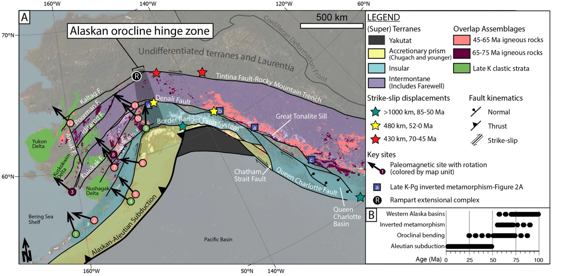
(A) Shaded relief satellite image of the Alaskan-Canadian Cordillera overlain by pertinent superterranes, fault systems, subduction-related igneous belts, and sedimentary strata. Terrane boundaries are modified from Colpron and Nelson (2011), and geologic map units are compiled from Wilson et al. (2015), Cui et al. (2017), and Colpron et al. (2016). See Supplemental Material S5 (text footnote 5) for rotations associated with paleomagnetic sites. Inverted metamorphism sites: a—Regan et al. (2024); b—McKenzie et al. (2024); c—Crawford et al. (1987). F—fault; K—Cretaceous; Pg—Paleogene. (B) Timeline of pertinent tectonic processes operating in the Alaskan-Canadian Cordillera.
Terrane Assembly and Magmatism
The Alaskan orocline is expressed as curvature along major dextral strike-slip faults that span the cordillera from British Columbia to the Bering Sea. These structures in most places bound major terranes and thus delineate the lithospheric architecture of the northern part of the North American Cordillera (Fig. 1; Estève et al., 2020). The most pertinent features to development of the Alaskan orocline are the terranes presently outboard (south and west) of the Tintina-Kaltag fault system (Fig. 1). These terranes, including the Insular superterrane, Intermontane superterrane, and Farewell terrane, are curved subparallel to the bounding strike-slip faults and track CCW rotation of western Alaska during development of the Alaskan orocline (Coe et al., 1985, 1989). Although the timing and latitude of suturing of the Intermontane superterrane to the Laurentian margin are disputed, it is widely accepted that the Intermontane superterrane served as the backstop to which the Insular superterrane accreted (cf. Johnston, 2008; Nelson and Colpron, 2007). As such, the Late Cretaceous–Cenozoic latitudinal displacement of the Intermontane superterrane required by paleomagnetic inclination data (Johnston, 2008) would have also transported the Insular superterrane and the Alaskan orocline.
The timing of ocean basin closure and associated metamorphism bracket assembly of the cordilleran terranes to the Mesozoic, either by sequential accretion of terranes to the North American continent (Nelson and Colpron, 2007), or by assembly of a ribbon continent in the marine realm prior to final accretion to North America in the Late Cretaceous–Paleogene (Johnston, 2008). Along the Canadian Cordillera, east of the Alaskan orocline hinge, aggregation of the Insular and Intermontane superterranes is recorded by diachronous closure of an intervening marine basin system from the Early Cretaceous to Late Cretaceous, culminating in amphibolite-facies metamorphism of Jurassic–Cretaceous marine strata at various times along the margin (Crawford et al., 1987; Waldien et al., 2021). Syncollisional prograde metamorphism of sedimentary protoliths in the Insular-Intermontane suture developed an inverted metamorphic field gradient that is preserved in isolated exposures from south-central Alaska to at least as far south as central British Columbia (Figs. 1 and 2A; Crawford et al., 1987; Regan et al., 2024). Thrust-sense shear fabrics within the northern exposures (Yukon and Alaska) of the inverted metamorphic belt yield in situ U-Pb monazite ages ranging from ca. 72 to 56 Ma, which are interpreted to record the final phase of syncollisional shortening between the Insular and Intermontane superterranes (Fig. 2A; McKenzie et al., 2024; Regan et al., 2024). In southwestern Alaska, accretion of the Insular superterrane is interpreted from Cretaceous sedimentary basins that record progressive shortening between the Insular superterrane and inboard terranes (Trop and Ridgway, 2007; Hults et al., 2013; Box et al., 2019). The presence of localized depocenters between strike-slip fault systems in western Alaska demonstrates that the basins formed synchronously with motion on the strike-slip faults (Miller et al., 2002), including deep sedimentary basins beneath the active Yukon, Kuskokwim, and Nushagak River deltas (cf. Berg et al., 2020; Fig. 1). Folds within the Late Cretaceous marine strata record shortening and basin inversion related to docking of the Insular superterrane against the Farewell terrane prior to emplacement of crosscutting ca. 75–65 Ma igneous rocks (Miller et al., 2002).
The Alaskan-Canadian Cordillera records nearly continuous arc magmatism from the mid-Cretaceous to the Eocene (Gehrels et al., 2009), which also provides a record of changing tectonic boundary conditions related to terrane amalgamation. Along coastal British Columbia through Yukon, mid-to-Late Cretaceous plutonic belts strike parallel to the orogen and decrease in age from west to east (Gehrels et al., 2009). The ca. 70 Ma plutonic belt is preserved in a narrow zone of highly strained tabular plutons at the structural top of the inverted metamorphic belt and is continuous for >1000 km along strike (Great Tonalite Sill of Ingram and Hutton, 1994; Fig. 1). Late Cretaceous–Paleogene igneous rocks west of the orocline hinge consist of regionally distributed (~500 km width; Fig. 1) exposures of shallowly exhumed volcano-plutonic complexes hosted within low-grade metamorphic or sedimentary rocks (Moll-Stalcup, 1994). The Late Cretaceous igneous rocks from western Alaska display calc-alkalic compositions that have a broad range of SiO2 concentrations (Moll-Stalcup, 1994; Fig. 2B; see Table S1 in the Supplemental Material5). Igneous rocks younger than 65–60 Ma display bimodal SiO2 concentrations, indicative of dual melt sources, a hallmark of extensional tectonic settings (Fig. 2B; Table S2).
Figure 2
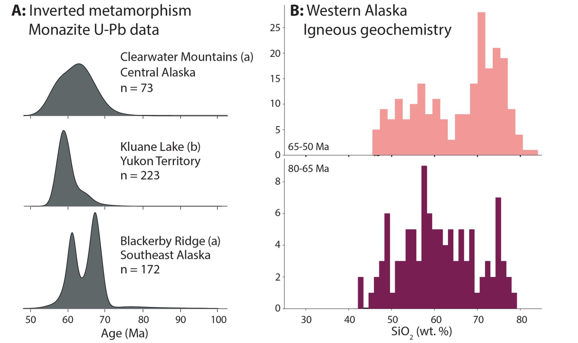
(A) Kernel density estimates of in situ monazite U-Pb ages from inverted metamorphic belts along the Canadian Cordillera (data from Regan et al., 2024; McKenzie et al., 2024). (B) Histogram of Late Cretaceous (bottom) and Paleogene (top) igneous rock SiO2 concentrations from western Alaska.
Strike-Slip Fault Displacements
Throughout the Alaskan-Canadian Cordillera, Late Cretaceous–Cenozoic dextral strike-slip faultsaccommodated northward displacement of cordilleran terranes toward the Bering Sea (Redfield et al., 2007). East of the orocline hinge, displacement primarily took place along three major fault systems: the Tintina fault (~430 km of slip, ca. 68–45 Ma; Gabrielse et al., 2006), Denali fault (~480 km of slip, ca. 52–0 Ma; Waldien et al., 2021); and the Border Ranges fault (>1000 km of slip, ca. 85–50 Ma; Pavlis and Roeske, 2007). West of the orocline hinge, >400 km of cumulative strike-slip motion was distributed between at least eight subparallel faults, several of which are interpreted to have accommodated dextral slip beginning ca. 100–85 Ma (Fig. 1; Miller et al., 2002). Slip on the entire network of faults records the margin-parallel component of oblique convergence between North America and the Pacific basin in response to multiple tectonic drivers across space and time (Miller et al., 2002; Redfield et al., 2007).
Vertical-Axis Rotation of Western Alaska
Oroclinal bending of southern Alaska is expressed as the curvature of regional geologic belts and recorded by vertical-axis rotations interpreted from paleomagnetic declination data (e.g., Coe et al., 1985, 1989). To better understand tectonic causes leading to vertical-axis rotations in western Alaska, we compiled the published paleomagnetic data, excluding data with poor paleohorizontal control, and used the mathematical framework of Demarest (1983) to recalculate vertical-axis rotation values relative to current Late Cretaceous and Paleogene reference poles for North America (Table S3).
The resulting 31 paleomagnetic sites yielded updated vertical-axis rotation values that are less dispersed than those in the original sources, and most sites record CCW rotation (Fig. 3; Table S4). Dispersion persisting in the data can be partly attributed to the proximity of paleomagnetic sites to dextral strike-slip faults, resulting in clockwise (CW) rotation of fault blocks concurrent with CCW rotation of western Alaska. A clear example of this competition between rotation mechanisms is expressed in the Matanuska Valley, which is located between the dextral Border Ranges and Castle Mountain fault systems and records 11° ± 9° of net CW rotation despite being located within the orocline hinge (#9 on Fig. 1; “Matanuska” on Fig. 3).
The data fall on an array wherein older rocks record higher average magnitudes of net CCW rotation than younger rocks (Fig. 3). Due to limited paleomagnetic data on rocks between ca. 150 and 75 Ma in western Alaska, the onset of vertical-axis rotation is not well recorded in the data. However, we interpret the trend of mean vertical-axis rotations to record progressive net CCW rotation of western Alaska from at least 75 to 55 Ma. Sites in rocks younger than ca. 55 Ma are affected by large uncertainties, which are generally attributed to low sample density, but may also record modest net CCW rotation (Thrupp and Coe, 1986).
Figure 3
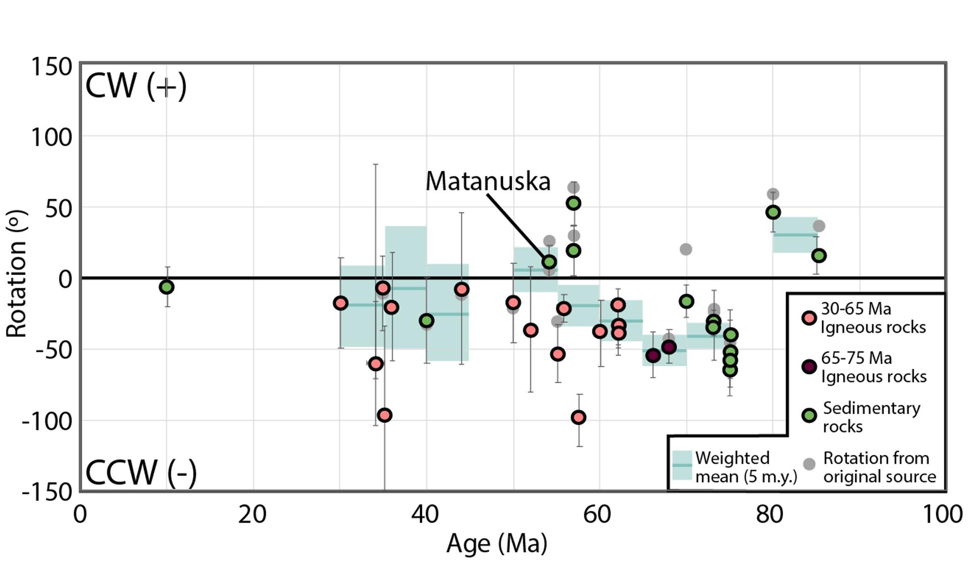
Paleomagnetic vertical-axis rotation data vs. age. Recalculated data points are colored according to map units in Figure 1 and binned into 5 m.y. weighted means with 1σσ uncertainties (blue bars). CW—clockwise; CCW—counterclockwise.
Along-Strike Transition in Geologic Character
The data summarized above demonstrate fundamental differences in the geology of the Alaskan-Canadian Cordillera through the Alaskan orocline. East of the orocline hinge, the Late Cretaceous–Paleogene geologic evolution of the Canadian Cordillera involved high-grade metamorphism and regional shortening along the Insular-Intermontane suture, highly localized arc magmatism, and translation along three dominant strike-slip faults. West of the orocline hinge, the Late Cretaceous–Paleogene geologic evolution of western Alaska involved Late Cretaceous sedimentary basin formation, widespread arc volcanism that transitioned to bimodal volcanism at ca. 65 Ma, dextral translation along several strike-slip faults, and progressive CCW rotation of the entire region. Because the hinge of the Alaskan orocline separates these two regions with distinct Late Cretaceous–Paleogene geologic histories, we propose that they were shaped by a common tectonic process that included oroclinal bending of Alaska.
Below, we present a tectonic model that accounts for the along-strike transition in the Late Cretaceous–Paleogene geologic character of the Alaskan-Canadian Cordillera and oroclinal bending of Alaska. Critical geologic observations honored by the model include the following:
(1) CCW vertical-axis rotation and basin formation in western Alaska were coeval with inverted metamorphism and regional shortening along the Canadian Cordillera.
(2) Dextral strike-slip faults in western Alaska began accumulating slip as early as 100 Ma, whereas dextral slip localized onto the eastern Tintina, Denali, and Border Ranges faults after 85 Ma.
(3) Displacement on the Tintina fault (ca. 68–45 Ma) largely preceded displacement on the Denali fault (ca. 52–0 Ma).
Figure 4
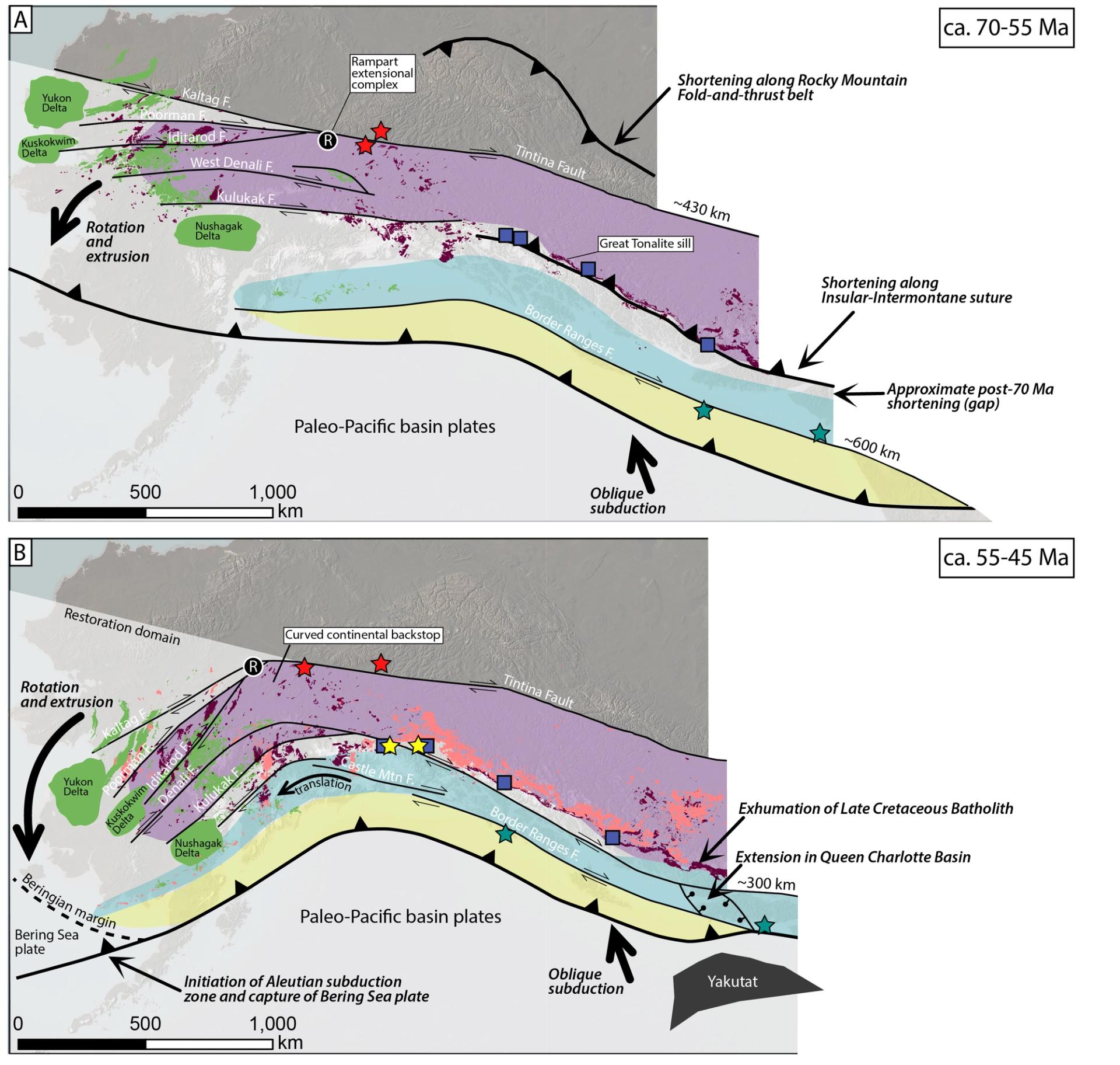
Schematic tectonic restorations illustrating development of the Alaskan orocline. All faults (F) present in each time interval were active during that time interval. See Figure 1 for map unit colors, symbols, and the 0 Ma time interval. Strike-slip displacements represent minimum separation estimates derived from mapped strike-slip faults only.
Lateral Escape and Development of the Alaskan Orocline
Late Cretaceous–Cenozoic strike-slip motion in the Alaskan-Canadian Cordillera has been envisioned as a form of tectonic escape wherein lithosphere was translated from the Canadian Cordillera to the Bering Sea (Redfield et al., 2007). Although this model provides an elegant link between cordilleran strike-slip faulting and onset of the Aleutian subduction zone (e.g., Scholl, 2007), the now-recognized differences in timing of slip among the cordilleran strike-slip faults and ca. 72–56 Ma shortening and associated inverted metamorphism along the Insular-Intermontane suture (Regan et al., 2024) require modification of the model. We propose a revised escape tectonics model that calls upon Late Cretaceous–Paleogene shortening along the Insular-Intermontane suture as a mechanism to extrude western Alaska, initiate Aleutian subduction, and establish the curvature of the southern Alaskan margin.
We illustrate our tectonic model as a set of schematic palinspastic map restorations (Fig. 4). The restorations incorporate vertical-axis rotation of western Alaska, geologic estimates of strike-slip displacement, and associated dissection of igneous belts and sedimentary basins. Importantly, the restorations account only for displacement on mapped major faults and thus provide a minimum estimate of latitudinal terrane displacement compared to paleomagnetic data and other provenance indicators (e.g., Davidson and Garver, 2017; Tikoff et al., 2023). We contend that our model is compatible with data requiring larger latitudinal translation and that incorporating those data would change only the paleolatitude of the processes illustrated herein.
70–55 Ma
In the latest Cretaceous–Paleocene, geology-based strike-slip fault restorations place the Insular superterrane at least 800 km south of its present location. The marine basin system between the Insular and Intermontane superterranes had completely closed by ca. 85 Ma (Waldien et al., 2021), and rocks within the suture experienced amphibolite-facies metamorphic conditions (Crawford et al., 1987; McKenzie et al., 2024; Regan et al., 2024). Dextral displacement accumulated on the Tintina and Border Ranges fault systems in response to oblique subduction across the cordillera (Pavlis and Roeske, 2007; Johnston, 2008). This region of partitioned oblique convergence and associated metamorphism transitioned northwestward into a zone of distributed strike-slip faulting, localized sedimentary basins, and widespread volcanism in present-day western Alaska. Near the transition between these domains, localized extensional exhumation of high-pressure metamorphic rocks within the Intermontane superterrane south of the Tintina fault (Rampart extensional complex; Fig. 4A) records bending of the lithosphere within the hinge zone of the Alaskan orocline (Till et al., 2007). This extension is kinematically compatible with CCW vertical-axis rotation of western Alaska and associated bending of all faults and geologic belts south of the Rampart extensional complex.
We interpret Late Cretaceous dextral strike-slip faulting in western Alaska to record lateral extrusion of that region during oblique closure of the marine basin system between the Insular and Intermontane superterranes. Synchronous lateral extrusion and CCW vertical-axis rotation of western Alaska initiated in response to a gradient in the magnitude of shortening along strike of the Insular-Intermontane suture during the Late Cretaceous, which lasted into the Paleogene.
55–45 Ma
In the early Eocene, geology-based strike-slip fault restorations place the Insular superterrane at least 400 km south of its present location. Localized slip on the Tintina and Border Ranges fault systems had waned, and translation was transferred primarily to the Denali fault and within the accretionary complex terranes. Along the Canadian Cordillera, dextral slip on the Denali fault system synchronous with initiation of the Queen Charlotte transform fault resulted in dissection of the Insular superterrane by extension in the Queen Charlotte Basin, eventually leading to localization of the Queen Charlotte fault (Rusmore et al., 2010). The multistranded strike-slip fault system and regions of extension along the Canadian Cordillera facilitated exhumation of the Late Cretaceous batholith and associated metamorphic rocks (Hollister and Andronicos, 2006). In western Alaska, dextral slip took place on multiple fault strands, including the Denali fault (Miller et al., 2002). Lateral extrusion and CCW rotation of western Alaska caused convergence between the Beringian margin and oceanic plates to the south, which established the Aleutian subduction zone and captured a fragment of seafloor (Bering Sea plate) by ca. 50 Ma (Scholl, 2007).
We interpret the waning Tintina fault slip and rotation of western Alaska by ca. 45 Ma to have established the curvature of the Intermontane superterrane at that time. The thick lithospheric mantle of the continental terranes inboard of the Denali fault (Estève et al., 2020), cessation of extension in the Rampart extensional complex (Till et al., 2007), and thermochronologic data from the orocline hinge adjacent to the north side of the Denali fault (Benowitz et al., 2022) imply that the continental terranes north of the Denali fault served as a curved backstop that was established by ca. 45 Ma. The curvature of this backstop and transfer of strike-slip motion to the Denali fault at ca. 50 Ma suggest that lithosphere outboard of the Denali fault has been translated through the orocline hinge since the early Eocene (e.g., Glen, 2004). Subsequent tightening of the Alaskan orocline may have been facilitated by such translation through the orocline hinge and Miocene subduction of the buoyant Yakutat oceanic plateau terrane with the southern Alaska margin (Redfield et al., 2007).
Synthesis and Conclusions
The data summarized herein demonstrate that CCW rotation and lateral extrusion of southwestern Alaska can be kinematically and temporally linked to shortening along the Insular-Intermontane suture zone. These processes were also contemporaneous with other major changes in the Alaskan-Canadian Cordillera, including shortening along the length of the Rocky Mountain fold-and-thrust belt (Johnston, 2008), a switch from transpression to transtension along the Canadian Cordillera (Hollister and Andronicos, 2006), an abrupt shift in the locus and tempo of arc magmatism (Gehrels et al., 2009), and accretion of voluminous clastic material in the Chugach accretionary prism (e.g., Davidson and Garver, 2017). We interpret the sum of these processes to record final assembly of the cordilleran terranes to the North American continent, followed by a shift in the plate-boundary forces and relative plate motion related to onset of the Aleutian subduction zone along the curved southern Alaskan margin (e.g., Scholl, 2007).
Vertical-axis rotation and lateral tectonic escape along strike-slip faults are widely observed processes in continental collision zones and have been shown to be kinematically linked to subduction dynamics in nearby trenches (e.g., Tapponnier et al., 1982; Reilinger et al., 2006). Here, we have extended the application of this tectonic model to the Alaskan-Canadian Cordillera to explain synchronous CCW vertical-axis rotation of western Alaska, shortening along the length of the Canadian Cordillera, dextral strike-slip faulting in both regions, and initiation of the Aleutian subduction zone. Considering the present data informing the geologic evolution of the Alaskan-Canadian Cordillera, we propose that the Alaskan orocline developed progressively over the Late Cretaceous and Paleogene as southwestern Alaska was extruded and rotated away from oblique terrane collisions in the Canadian Cordillera.
Acknowledgments
This work was funded by National Science Foundation awards EAR 2218919 (Waldien), EAR 2218920 (Regan), and EAR 2317912 (Housen). T. Pavlis and S. Johnston provided insightful reviews that strengthened the manuscript.
References
- Benowitz, J.A., Roeske, S.M., Regan, S.P., Waldien, T.S., Elliott, J.L., and O’Sullivan, P.B., 2022, Large-scale, crustal-block vertical extrusion between the Hines Creek and Denali faults coeval with slip localization on the Denali fault since ca. 45 Ma, Hayes Range, Alaska, USA: Geosphere, v. 18, no. 3, p. 1030–1054, https://doi.org/10.1130/GES02466.1.
- Berg, E.M., Lin, F.C., Allam, A., Schulte‐Pelkum, V., Ward, K.M., and Shen, W., 2020, Shear velocity model of Alaska via joint inversion of Rayleigh wave ellipticity, phase velocities, and receiver functions across the Alaska Transportable Array: Journal of Geophysical Research: Solid Earth, v. 125, no. 2, https://doi.org/10.1029/2019JB018582.
- Box, S.E., Karl, S.M., Jones, J.V., III, Bradley, D.C., Haeussler, P.J., and O’Sullivan, P.B., 2019, Detrital zircon geochronology along a structural transect across the Kahiltna assemblage in the western Alaska Range: Implications for emplacement of the Alexander-Wrangellia-Peninsular terrane against North America: Geosphere, v. 15, no. 6, p. 1774–1808, https://doi.org/10.1130/GES02060.1.
- Capitanio, F.A., Faccenna, C., Zlotnik, S., and Stegman, D.R., 2011, Subduction dynamics and the origin of Andean orogeny and the Bolivian orocline: Nature, v. 480, no. 7375, p. 83–86, https://doi.org/10.1038/nature10596.
- Coe, R.S., Globerman, B.R., Plumley, P.W., and Thrupp, G.A., 1985, Paleomagnetic results from Alaska and their tectonic implications, in Howell, D.G., ed., Tectonostratigraphic Terranes of the Circum-Pacific Region: American Association of Petroleum Geologists Circum-Pacific Council for Energy and Mineral Resources Earth Sciences Series 1, p. 85–108, https://archives.datapages.com/data/circ_pac/1/85_b.htm.
- Coe, R.S., Globerman, B.R., and Thrupp, G.A., 1989, Rotation of central and southern Alaska in the early Tertiary: Oroclinal bending by megakinking?, in Kissel, C., and Laj, C., eds., Paleomagnetic Rotations and Continental Deformation: Dordrecht, Netherlands, Springer, North Atlantic Treaty Organization (NATO) Advanced Study Institutes (ASI) Series 254, p. 327–342, https://doi.org/10.1007/978-94-009-0869-7_20.
- Colpron, M., and Nelson, J.L., 2011, A Digital Atlas of Terranes for the Northern Cordillera: British Columbia Ministry of Energy and Mines, British Columbia Geological Survey (BCGS) GeoFile 2011–11, https://data.geology.gov.yk.ca/Reference/95879#InfoTab.
- Colpron, M., Israel, S., Murphy, D., Pigage, L., and Moynihan, D., 2016, Yukon Bedrock Geology Map: Yukon Geological Survey Open-File 2016-1, scale 1:1,000,000, 1 sheet, https://data.geology.gov.yk.ca/Reference/95934#InfoTab.
- Crawford, M.L., Hollister, L.S., and Woodsworth, G.J., 1987, Crustal deformation and regional metamorphism across a terrane boundary, Coast Plutonic Complex, British Columbia: Tectonics, v. 6, no. 3, p. 343–361, https://doi.org/10.1029/TC006i003p00343.
- Cui, Y., Miller, D., Schiarizza, P., and Diakow, L.J., 2017, British Columbia Digital Geology: British Columbia Ministry of Energy, Mines and Petroleum Resources, British Columbia Geological Survey Open-File 2017-8, 9 p., data version 2019–12–19, https://www2.gov.bc.ca/gov/content/industry/mineral-exploration-mining/british-columbia-geological-survey/geology/bcdigitalgeology.
- Davidson, C., and Garver, J.I., 2017, Age and origin of the Resurrection ophiolite and associated turbidites of the Chugach–Prince William terrane, Kenai Peninsula, Alaska: The Journal of Geology, v. 125, no. 6, p. 681–700, https://doi.org/10.1086/693926.
- Demarest, H.H., Jr., 1983, Error analysis for the determination of tectonic rotation from paleomagnetic data: Journal of Geophysical Research: Solid Earth, v. 88, no. B5, p. 4321–4328, https://doi.org/10.1029/JB088iB05p04321.
- Estève, C., Audet, P., Schaeffer, A.J., Schutt, D.L., Aster, R.C., and Cubley, J.F., 2020, Seismic evidence for craton chiseling and displacement of lithospheric mantle by the Tintina fault in the northern Canadian Cordillera: Geology, v. 48, no. 11, p. 1120–1125, https://doi.org/10.1130/G47688.1.
- Gabrielse, H., Murphy, D.C., and Mortensen, J.K., 2006, Cretaceous and Cenozoic dextral orogen-parallel displacements, magmatism, and paleogeography, north-central Canadian Cordillera, in Haggart, J.W., Enkin, R.J., and Monger, J.W.H., eds., Paleogeography of the North American Cordillera: Evidence For and Against Large-Scale Displacements: Geological Association of Canada Special Paper 46, p. 255–276.
- Gehrels, G., Rusmore, M., Woodsworth, G., Crawford, M., Andronicos, C., Hollister, L., Patchett, J., Ducea, M., Butler, R., Klepeis, K., and Davidson, C., 2009, U-Th-Pb geochronology of the Coast Mountains batholith in north-coastal British Columbia: Constraints on age and tectonic evolution: Geological Society of America Bulletin, v. 121, no. 9–10, p. 1341–1361, https://doi.org/10.1130/B26404.1.
- Glen, J.M.G., 2004, A kinematic model for the southern Alaska orocline based on regional fault patterns, in Sussman, A., and Weil, A.B., eds., Orogenic Curvature: Geological Society of America Special Paper 383, p. 161–172, https://doi.org/10.1130/0-8137-2383-3(2004)383[161:AKMFTS]2.0.CO;2.
- Hollister, L.S., and Andronicos, C.L., 2006, Formation of new continental crust in western British Columbia during transpression and transtension: Earth and Planetary Science Letters, v. 249, no. 1–2, p. 29–38, https://doi.org/10.1016/j.epsl.2006.06.042.
- Hults, C.P., Wilson, F.H., Donelick, R.A., and O’Sullivan, P.B., 2013, Two flysch belts having distinctly different provenance suggest no stratigraphic link between the Wrangellia composite terrane and the paleo-Alaskan margin: Lithosphere, v. 5, no. 6, p. 575–594, https://doi.org/10.1130/L310.1.
- Ingram, G.M., and Hutton, D.H., 1994, The Great Tonalite Sill: Emplacement into a contractional shear zone and implications for Late Cretaceous to early Eocene tectonics in southeastern Alaska and British Columbia: Geological Society of America Bulletin, v. 106, no. 5, p. 715–728, https://doi.org/10.1130/0016-7606(1994)106<0715:TGTSEI>2.3.CO;2.
- Johnston, S.T., 2008, The cordilleran ribbon continent of North America: Annual Reviews in Earth and Planetary Sciences, v. 36, no. 1, p. 495–530, https://doi.org/10.1146/annurev.earth.36.031207.124331.
- Johnston, S.T., Weil, A.B., and Gutiérrez-Alonso, G., 2013, Oroclines: Thick and thin: Geological Society of America Bulletin, v. 125, no. 5–6, p. 643–663, https://doi.org/10.1130/B30765.1.
- McKenzie, W.F., Dyck, B., Gibson, H.D., and Larson, K., 2024, A record of Late Cretaceous to early Paleogene Insular terrane accretion within the northern Cordillera: Insights from monazite petrochronology across the Kluane Schist, southwest Yukon, Canada: Geological Society of America Bulletin, v. 136, no. 9/10, p. 3510–3526, https://doi.org/10.1130/B37198.1.
- Miller, M.L., Bradley, D.C., Bundtzen, T.K., and McClelland, W., 2002, Late Cretaceous through Cenozoic strike-slip tectonics of southwestern Alaska: The Journal of Geology, v. 110, no. 3, p. 247–270, https://doi.org/10.1086/339531.
- Moll-Stalcup, E.J., 1994, Latest Cretaceous and Cenozoic magmatism in mainland Alaska, in Plafker, G., and Berg, H.C., eds., The Geology of Alaska: Boulder, Colorado, Geological Society of America, Geology of North America, v. G-1, p. 589–618, https://doi.org/10.1130/DNAG-GNA-G1.589.
- Morales, J., Azañón, J.M., Stich, D., Roldán, F.J., Pérez-Peña, J.V., Martín, R., and González-Ramón, A., 2015, The 2012–2013 earthquake swarm in the eastern Guadalquivir basin (south Spain): A case of heterogeneous faulting due to oroclinal bending: Gondwana Research, v. 28, no. 4, p. 1566–1578, https://doi.org/10.1016/j.gr.2014.10.017.
- Nelson, J., and Colpron, M., 2007, Tectonics and metallogeny of the British Columbia, Yukon and Alaskan Cordillera, 1.8 Ga to the present, in Goodfellow, W.D., ed., Mineral Deposits of Canada: A Synthesis of Major Deposit-Types, District Metallogeny, the Evolution of Geological Provinces, and Exploration Methods: Geological Association of Canada, Mineral Deposits Division, Special Publication 5, p. 755–791, https://cmscontent.nrs.gov.bc.ca/geoscience/PublicationCatalogue/External/EXT060.pdf.
- Pavlis, T.L., and Roeske, S.M., 2007, The Border Ranges fault system, southern Alaska, in Ridgway, K.D., Trop, J.M., Glen, J.M.G., and O’Neill, J.M., eds., Tectonic Growth of a Collisional Continental Margin: Crustal Evolution of Southern Alaska: Geological Society of America Special Paper 431, p. 95–127, https://doi.org/10.1130/2007.2431(05).
- Redfield, T.F., Scholl, D.W., Fitzgerald, P.G., and Beck, M.E., Jr., 2007, Escape tectonics and the extrusion of Alaska: Past, present, and future: Geology, v. 35, no. 11, p. 1039–1042, https://doi.org/10.1130/G23799A.1.
- Regan, S.P., Holland, M.E., Waldien, T.S., Miller, M., Taylor, P., Kylander-Clark, A., Marble, S., and Hofmann, F., 2024, Orogen-scale inverted metamorphism during Cretaceous–Paleogene terminal suturing along the North American Cordillera, Alaska, USA: Geology, v. 52, p. 933–938, https://doi.org/10.1130/G52614.1.
- Reilinger, R., et al., 2006, GPS constraints on continental deformation in the Africa‐Arabia‐Eurasia continental collision zone and implications for the dynamics of plate interactions: Journal of Geophysical Research: Solid Earth, v. 111, no. B5, https://doi.org/10.1029/2005JB004051.
- Rusmore, M.E., Bogue, S.W., Dodson, K., Farley, K.A., and Woodsworth, G.J., 2010, Deformation of continental crust along a transform boundary, Coast Mountains, British Columbia: Tectonics, v. 29, no. 4, TC4007, https://doi.org/10.1029/2009TC002502.
- Scholl, D.W., 2007, Viewing the tectonic evolution of the Kamchatka-Aleutian (KAT) connection with an Alaska crustal extrusion perspective, in Eichelberger, J., Gordeev, E., Izbekov, P., Kasahara, M., and Lees, J., eds., Volcanism and Subduction: The Kamchatka Region: American Geophysical Union Geophysical Monograph 172, p. 3–35, https://doi.org/10.1029/172GM03.
- Tapponnier, P., Peltzer, G., Le Dain, A.Y., Armijo, R., and Cobbold, P., 1982, Propagating extrusion tectonics in Asia: New insights from simple experiments with plasticine: Geology, v. 10, no. 12, p. 611–616, https://doi.org/10.1130/0091-7613(1982)10<611:PETIAN>2.0.CO;2.
- Thrupp, G.A., and Coe, R.S., 1986, Early Tertiary paleomagnetic evidence and the displacement of southern Alaska: Geology, v. 14, no. 3, p. 213–217, https://doi.org/10.1130/0091-7613(1986)14<213:ETPEAT>2.0.CO;2.
- Tikoff, B., Housen, B.A., Maxson, J.A., Nelson, E.M., Trevino, S., and Shipley, T.F., 2023, Hit-and-run model for Cretaceous–Paleogene tectonism along the western margin of Laurentia, in Whitmeyer, S.J., Williams, M.L., Kellett, D.A., and Tikoff, B., eds., Laurentia: Turning Points in the Evolution of a Continent: Geological Society of America Memoir 220, p. 659–705, https://doi.org/10.1130/2022.1220(32).
- Till, A.B., Roeske, S.M., Bradley, D.C., Friedman, R., and Layer, P.W., 2007, Early Tertiary transtension-related deformation and magmatism along the Tintina fault system, Alaska, in Till, A.B., Roeske, S.M., Sample, J.C., and Foster, D.A., eds., Exhumation Associated with Continental Strike-Slip Fault Systems: Geological Society of America Special Paper 434, p. 233–264, https://doi.org/10.1130/2007.2434(11).
- Trop, J.M., and Ridgway, K.D., 2007, Mesozoic and Cenozoic tectonic growth of southern Alaska: A sedimentary basin perspective, in Ridgway, K.D., Trop, J.M., Glen, J.M.G., and O’Neill, M.O., eds., Tectonic Growth of a Collisional Continental Margin: Crustal Evolution of Southern Alaska: Geological Society of America Special Paper 431, p. 55–94, https://doi.org/10.1130/2007.2431(04).
- Waldien, T.S., Roeske, S.M., and Benowitz, J.A., 2021, Tectonic underplating and dismemberment of the Maclaren‐Kluane schist records Late Cretaceous terrane accretion polarity and ~480 km of post–52 Ma dextral displacement on the Denali fault: Tectonics, v. 40, no. 10, https://doi.org/10.1029/2020TC006677.
- Weil, A.B., Yonkee, A., and Sussman, A., 2010, Reconstructing the kinematic evolution of curved mountain belts: A paleomagnetic study of Triassic red beds from the Wyoming salient, Sevier thrust belt, USA: Geological Society of America Bulletin, v. 122, no. 1–2, p. 3–23, https://doi.org/10.1130/B26483.1.
- Wilson, F.H., Hults, C.P., Mull, C.G., and Karl, S.M., 2015, Geologic Map of Alaska: U.S. Geological Survey Scientific Investigations Map 3340, 196 p., 2 sheets, scale 1:1,584,000, https://doi.org/10.3133/sim3340.
