

In this article
Authors
Z. Molitor*
Department of Earth and Planetary Sciences, Yale University, New Haven, Connecticut, USA
F. Link
Institute of Geosciences, Johannes Gutenberg University Mainz, Mainz, Germany
M. Long
Department of Earth and Planetary Sciences, Yale University, New Haven, Connecticut, USA
J. Ague
Department of Earth and Planetary Sciences, Yale University, New Haven, Connecticut, USA
Abstract
The average thickness of continental crust is ~30–40 km far-removed from plate boundaries and in the absence of significant topography. Nonetheless, there are many examples of anomalously thick crust (>40–50 km) that have been stable over hundreds to thousands of m.y. Here, we present new estimates of crustal thickness based on seismic data from the state of Ohio in the United States. This region is deep within the interior of the North American plate and is characterized by extremely low topographic relief; however, crustal thickness is ~60 km beneath the central part of the state. Anomalously thick crust, together with narrow, positive gravity anomalies, suggest that the lower crust beneath central Ohio is characterized by a mafic crustal root. Mafic material was intruded and underplated beneath the North American lithosphere during Midcontinent rifting at ~1109 Ma. Following rifting, the region experienced significant contraction and shortening during the collisional Grenville Orogeny. We propose that the combination of neutrally buoyant mafic material in the lower crust and short wavelength Moho relief is necessary for the long-term stability of thick crust beneath Ohio. This model reconciles seismic and gravity models of the crustal structure and geologic history of the region, suggesting that part of the Midcontinent Rift was deformed and imbricated within the Grenville Front in the Proterozoic Eon.
Introduction
Intraplate continental crustal thickness generally falls between ~30 and 40 km (e.g., Christensen and Mooney, 1995). Deviations from this norm are expected in active or recently active plate boundary regions, such as continental rifts or orogenic systems. On long timescales (>100 m.y.), the continental crust is expected to return to this average value through isostatic adjustment combined with processes such as erosion, delamination, and crustal or lithospheric mantle flow (e.g., Dewey et al., 1993).
However, there are many notable examples in which the continental crust has remained anomalously thick over long timescales of up to ~1 Ga (e.g., Fischer, 2002). Many of these examples are not associated with a commensurate topographic expression above the thick crust, as would be predicted by an Airy isostasy model. Variability in Moho topography, amounting to <10 km across tectonic provinces, is commonly observed in both Precambrian and Phanerozoic intraplate continental crust (e.g., Eaton et al., 2006; Luo et al., 2021). However, extreme variability of ≥10 km is rarely observed outside of plate boundaries. For many of these regions, we do not yet have a comprehensive understanding of the original driver(s) of crustal thickening, the subsequent mechanism(s) promoting long-term stability of the thick crust, or the precise three-dimensional geometry and structure of the present-day crustal root.
In this article, we address an understudied example of overthickened continental crust (~60 km) beneath the state of Ohio in the Midwest region of the United States (Long et al., 2019, 2020; Fig. 1). Overthickened crust is also observed elsewhere in the Midwest region of the central United States (Yang et al., 2017). This value is ~20 km thicker than adjacent regions, and it is not associated with significant topographic variations. The maximum topographic relief within Ohio is ~350 m, of which ~50–100 m is due to incision of Pleistocene rivers. The anomaly is spatially associated with the westward termination of the Grenville Front and with a Bouguer gravity anomaly high.
Geologic Background
The tectonic history of the continental basement beneath the central (Midwest) United States spans much of the Proterozoic Eon (~1690–950 Ma). The basement of the Midwest region, including western Ohio, is composed of the Mazatzal and Granite–Rhyolite provinces; the Mazatzal province is the oldest (~1700–1600 Ma; Whitmeyer and Karlstrom, 2007). The juvenile crust of the Granite–Rhyolite province was created and accreted between ~1550 and 1350 Ma (Bickford and Van Schmus, 1985). This juvenile crust was subsequently intruded by A-type granites between 1480 and 1350 Ma (Karlstrom and Humphreys, 1998). Altogether, the Mazatzal and Granite–Rhyolite provinces and associated A-type granites compose much of the basement in the southwestern portion of the Midwest United States (Fig. 1).
The Grenville Orogeny followed the intrusion of A-type granites. Whitmeyer and Karlstrom (2007) define the Grenville as having occurred between 1300 and 900 Ma. The earliest phases of the Grenville (sensu-lato), Elzevirian (~1250–1220 Ma), and Shawinigan orogenies (~1190–1160 Ma), are now distinguished from collision of the Grenville province with Laurentia and formation of Rodinia (“collisional Grenville Orogen,” Swanson-Hysell et al., 2023).
Following the Elzevirian and Shawinigan accretionary orogenic episodes, the Midcontinent Rift formed at ~1109 Ma (Swanson-Hysell et al., 2019). This rifting event crosscuts all pre-Grenville tectonic elements in the Midwest region, including the Mazatzal and Granite–Rhyolite provinces (Fig. 1). Although the easternmost arm of the Midcontinent Rift system was traditionally limited to the state of Michigan, comprehensive modeling of gravity anomalies led Stein et al. (2018) and Elling et al. (2020) to suggest that the rift likely extends to the south (Fig. 1).
After Midcontinent rifting, the collisional Grenville Orogeny began at ~1090 Ma (Swanson-Hysell et al., 2023). This orogeny, which culminated in the formation of the super-continent Rodinia, was the last major orogenic episode in this region prior to the onset of Paleozoic Appalachian orogenesis in the Ordovician Period (Karabinos et al., 2017).
Figure 1
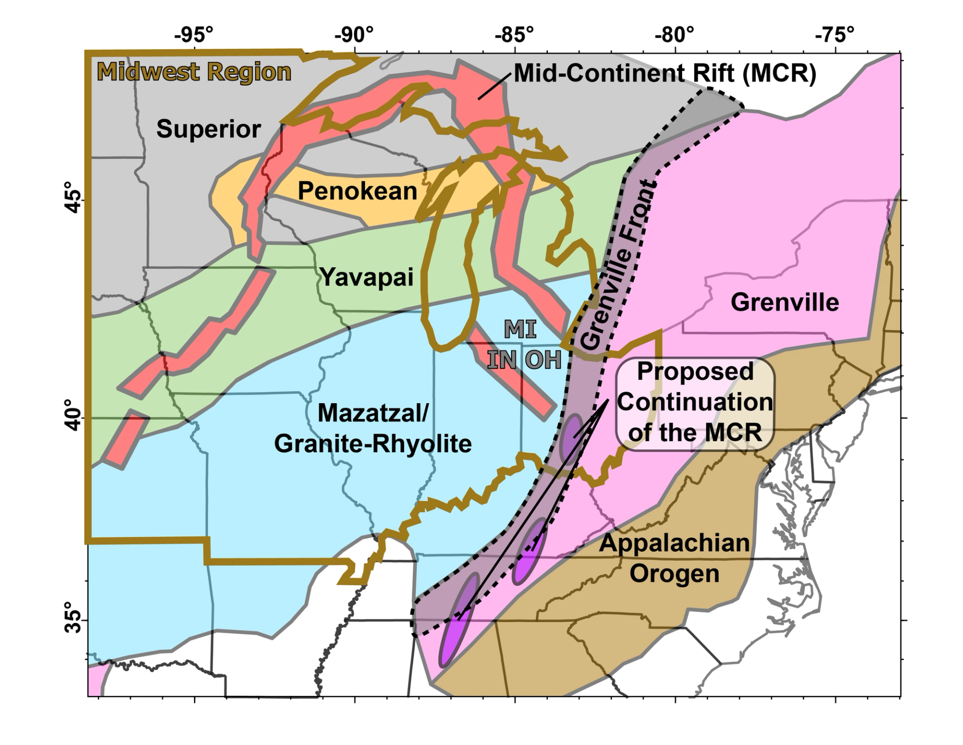
Simplified map of major tectonic provinces in the central United States, modified from Marshak et al. (2017). Notable features that transect central Ohio, such as the Grenville Front and Midcontinent Rift system, are also displayed, including the proposed eastern arm suggested by Stein et al. (2018) based on gravity anomalies. The Midwest region, mentioned throughout the text, is shown in brown. Three states mentioned in the text are labeled with gray abbreviations: Indiana—IN; Michigan—MI; Ohio—OH.
Seismic Observations of Moho Depth Under Ohio
The MAGIC seismic experiment was conducted between 2013 and 2016 and extended from the central Appalachians through the Midwest region of the United States (Long et al., 2020). The anomalously thick (~60 km) crust beneath Ohio was documented in previous work based on MAGIC data (Long et al., 2019), but this observation warrants further discussion and study.
Long et al. (2019) determined that a mid-crustal seismic anomaly beneath the eastern United States was most likely related to a low-angle orogenic shear zone which developed during the Grenville Orogeny. This interpretation contrasted with previously published hypotheses based mainly on gravity data (e.g., Stein et al., 2018), which postulated that the Grenville front was not present in the eastern United States, and that anomalously high crustal densities in the region may reflect processes associated with the Midcontinent Rift. Here, we carry out new investigations of Moho structure beneath Ohio and determine the spatial relationships among overthickened crust, positive gravity anomalies, and the east-dipping Grenville front interface identified by Long et al. (2019) from MAGIC data.
In addition to the MAGIC seismic line, we present new Moho picks from broadband seismic stations in Ohio based on Ps wave conversions (see Acknowledgments). Teleseismic events with magnitudes between 5.0 and 7.5 within the epicentral distance range from 20° to 155° were selected. To ensure the quality of the waveforms, we conducted a three-step control process based on the signal-to-noise (SNR) ratio of the waveform data and receiver functions as well as a subsequent visual inspection. We calculated receiver functions using the multi-taper-correlation (MTC) method (Park and Levin, 2016) with an upper limit cut-off frequency of 1 Hz.
In the first analysis step, we employed the H-k stacking approach (Zhu and Kanamori, 2000), which provides insights into the average crustal thickness beneath each individual station, as well as first order bulk crustal properties based on the P-wave over S-wave velocity ratio (Vp/Vs). By stacking receiver function amplitudes at times corresponding to a grid of trial crustal thicknesses (20–80 km) and Vp/Vs ratios (1.5–2.1), we identified the best-fitting crustal parameters at the resulting maximum. The uncertainties on the crustal thickness estimates vary between 0.5 and 8 km.
Although the H-k stacking only allows an estimate of the crustal thickness directly beneath a station, a migration of the receiver function amplitudes along their raypaths allows a much better resolution of crustal features. We therefore applied a common conversion point (CCP) stacking approach. For this, we assumed a smoothed 1-D velocity model (ak135; Kennett et al., 1995). The individual receiver functions were migrated based on this velocity model, the slowness, and the backazimuth of the individual events. The amplitudes were summed on a regular grid and then interpolated and smoothed to receive the final CCP-images. Here, we show four 2-D profiles cross-cutting the best resolved areas of the model. Subsequently, we picked the Moho manually from the CCP images and produced a highly resolved 2-D Moho map of the study area (Fig. 2). Given the structural complexity of the Moho on the profiles in Figure 2, the H-k approach may not yield the best fit for crustal thickness due to the assumption of horizontal continuity. This caveat may explain the observed misfits between H-k and CCP derived thickness estimates.
We delineate two major bands of overthickened crust beneath the state of Ohio (Fig. 2). Band 1, running beneath the central part of the state, is associated with ~60 km thick crust and trends broadly north to south. This band is roughly 150–200 km wide and contrasts with the 40–45 km thick crust in the surrounding regions. The amplitude of the impedance (velocity times density) contrast at the Moho in Band 1, as expressed in the amplitude of converted Ps phases, is highly variable compared with the eastern part of the state. Previous, national-scale seismic studies have not identified this thickened zone (e.g., Shen and Ritzwoller, 2016), but Moho doublets have been identified (Schulte-Pelkum et al., 2017).
Band 2 is characterized by ~45–50 km thick crust running beneath the eastern part of the state, delineating an arcuate northeast-southwest trend (Fig. 2). This band is ~50 km wide—much narrower than Band 1. Additionally, the crustal thickness in Band 2 is comparable to crustal thickness variations that are well documented throughout the Midwest region (Shen and Ritzwoller, 2016). Lastly, there is no gravity anomaly associated with Band 2 (Fig. 2). As a result, we focus the following discussion solely on Band 1.
Both bands of overthickened crust appear to result from localized deformation in the deep crust that has perturbed the Moho. This is best shown in the CCP stacked receiver function profiles across central Ohio (Fig. 2). Band 1 is associated with relatively sharp Moho relief. Seismic profile A reveals a small (~50 km) piece of the Moho, which appears to be detached and imbricated between an ~40 km deep Moho to the west and an ~60 km deep Moho to the east (Fig. 2). We define imbrication to refer to localized deformation and stacking of large blocks along thrust faults.
Figure 2
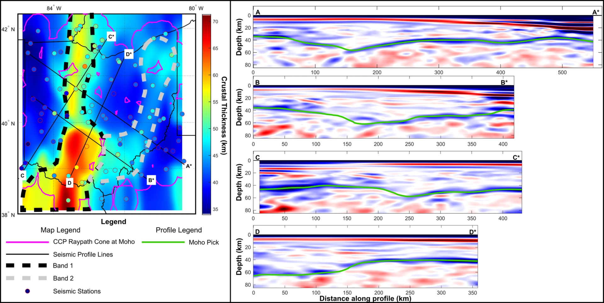
Map of seismic stations and crustal thickness beneath the state of Ohio. Four representative seismic sections are shown: two E-W sections (A and B) and two N-S sections (C and D). Cross sections of CCP-stack receiver functions are shown in representative NW–SE and NNE–SSW sections across Ohio. The fill color of the seismic stations corresponds to the crustal thickness determined by H-k stacking.
Density and Lithologic Character of the Lower Crust Beneath Central Ohio
Gravity anomalies are particularly sensitive to anomalous dense material in the crust and therefore may help delineate the relative roles of Midcontinent rifting and associated mafic underplating versus Grenville orogenesis in the creation and stability of Moho relief beneath Ohio. For our analysis, we utilize the national Bouguer gravity grid of Lyons and O’Hara (1999).
There are several positive gravity anomalies in Ohio, both in the central-western part of the state and in the eastern part (Fig. 3). Prominent curvilinear gravity highs in the central United States correspond to the Midcontinent Rift (Stein et al., 2018). Curvilinear, high-amplitude gravity highs are observed in the central and western part of Ohio. These anomalies follow from the Fort Wayne rift zone in northeastern Indiana and the well agreed upon eastern arm of the Midcontinent Rift in Michigan (Fig. 3).
Gravity anomalies in central Ohio (Anomaly 1, Fig. 3) were modeled by Elling et al. (2020), who suggested that they result from a combination of shallow mafic volcanics and a deep mafic underplate, emplaced during Midcontinent rifting. In addition, we note a small (<50 km diameter), positive, circular anomaly in the north-central part of Ohio (Anomaly 2, Fig. 3). Positive gravity anomalies may be associated with dense mafic intrusion into less dense intermediate-felsic crust, or alternatively, crustal thinning and mantle upwelling (e.g., Chappell and Kusznir, 2008; Elling et al., 2020). By comparing the prominent, near-linear gravity highs in the western part of the state to our new map of crustal thickness, we may delineate the relative role of Midcontinent rifting in generating and maintaining the thick crust beneath Ohio (Fig. 3).
First, we note that only the gravity highs in the central part of the state (Anomalies 1 and 2, Fig. 3) are associated with overthickened crust (Figs. 2 and 3). The extension of the Fort Wayne Rift through western Ohio is not associated with anomalous crustal thickness (Fig. 3). Hence, the presence of a gravity high does not uniquely predict the presence of overthickened crust. The gravity highs in central Ohio lie directly below the proposed Grenville deformation front (Fig. 1); indeed, they were previously utilized to delineate the Grenville Front in this region (McLaughlin, 1954; see also Stein et al., 2018). Notably, the gravity high associated with Band 1 is not continuous along the Grenville Front. As the magnitude of the gravity anomaly is most sensitive to shallow mafic volcanics (Elling et al., 2020), the north-south variations in the gravity anomaly may reflect a decrease in, or absence of, shallow volcanic material in the northern half of Band 1.
Models invoking Midcontinent rifting and Grenville orogenesis are not mutually exclusive in the context of the geologic history of the basement beneath Ohio. The positive gravity signatures and a large region of high seismic impedance amplitudes in the lower crust likely result from mafic material emplaced during rifting and are not indicative of Grenville deformation (Elling et al., 2020). However, sharp Moho topography, possible imbrication, and evidence for seismic anisotropy within the crust (Long et al., 2019; Fig. 2) all suggest that deformation of the middle to lower crust beneath central Ohio, including displacement of the Moho itself, took place during the collisional Grenville Orogeny following Midcontinent rifting.
Figure 3
(A) Bouguer gravity anomaly map of the central and eastern United States from the national Bouguer gravity grid of Lyons and O’Hara (1999). Black lines correspond to high gravity anomalies mentioned in the text, but unrelated to the Midcontinent Rift. Red lines correspond to high gravity anomalies potentially related to the Midcontinent Rift. Two prominent gravity anomalies are labeled (1 and 2) within Ohio and referenced in the text. Fort Wayne Rift; MCR—Midcontinent Rift; SR—Scranton Rift; SLR—St. Lawrence Rift. (B) Map of Ohio with Bouguer gravity raster (Lyons and O’Hara, 1999) and contours of crustal thickness from Figure 2.
Moho Structures and Tectonic History of Ohio’s Precambrian Basement
The structure and tectonic history of the basement beneath the Midwest region is not well understood due to the lack of Precambrian exposure. Yang et al. (2017) proposed five models that may explain observed crustal root zones in the Midwest, including a preexisting (i.e., Mazatzal-age) root, thickening by homogeneous shortening or continental underthrusting, magmatic underplating, or relamination. As discussed above, both Midcontinent rifting and Grenville orogenesis are proposed to have significantly affected the Precambrian basement in the eastern Midwest region.
The thickest (~60 km) band of crust, Band 1, is spatially associated with high-amplitude, narrow gravity highs attributed to Midcontinent rifting (Figs. 2 and 3). However, the gravity highs associated with thickened crust are present only beneath the Grenville deformation front (Figs. 1 and 3). Furthermore, the lower crust and Moho are apparently imbricated in this band (Fig. 2). We interpret the Moho structure and gravity data of Band 1 as resulting from, first, rifting and mafic underplating associated with Midcontinent rifting, followed by deformation and crustal shortening during the Grenville Orogeny (Fig. 4). The dense and thick crustal root is located within the lower plate of the Grenville frontal thrust, within the Mazatzal or Granite-Rhyolite province. The root zone and associated dense material apparently truncate older layers within the crust, suggesting that the dense material was emplaced after formation and reworking of the Mazatzal/Granite-Rhyolite province, consistent with the significantly younger age of Midcontinent rifting (Fig. 2; Swanson-Hysell et al., 2019). After Midcontinent rifting, the dense lower crust was imbricated by west-over-east thrust faults, forming imbricate, duplex structures (e.g., Fig. 2).
Although there are no apparent cross-cutting relationships between the east-verging thrust faults in the root zone and the Grenville frontal thrust, the timing of these structures is likely the same. The only event that significantly deformed the basement in the region after Midcontinent rifting was the Grenville Orogeny. The absence of similarly thick crust in the neighboring Fort Wayne Rift (Figs. 2 and 3) supports a role for deformation along the Grenville Front in imbricating and thickening the crust of Band 1. The imbrication of the Moho is observed only within and adjacent to the mafic underplate (Fig. 2). Rift-related thermal weakening coupled with structural reactivation of preexisting rift structures likely facilitated localization of Grenville-age contraction within the mafic underplate in the foreland of the Grenville orogenic system. Alternatively, a change in the plate boundary stress state may have reactivated the rift structures in the foreland after initial Grenville convergence (e.g., Clark and Bilham, 2008).
Returning to the models proposed by Yang et al. (2017), we may immediately rule out relamination and subduction zone processes, as these predominately affect the upper, Grenvillian plate. A preexisting, Calymmian Period or Paleoproterozoic root is unlikely, given the apparent cross-cutting relationships of the dense root relative to the surrounding Mazatzal/Granite–Rhyolite crust and the demonstrated age of Midcontinent Rift structures. Therefore, a combination of magmatic underplating during rifting, followed by Grenville-age contraction defines the structure and history of the root, indicating that two or three of the models presented by Yang et al. (2017) may be required to explain root generation and stability.
Figure 4
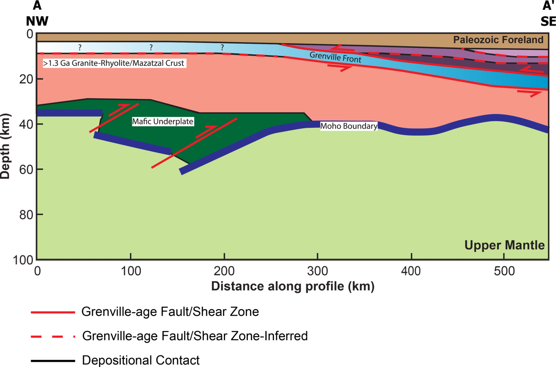
Interpretation of seismic line A-A’, trending NW–SE across central Ohio. The location of profile A-A’ is shown on Figure 2.
Stability of Dense Orogenic Root Zones in Deep Time
We propose that two effects may play a major role in the long-term (~1 Gyr) stability of overthickened continental crust beneath Ohio. In general, we do not expect such extreme crustal thickness variations to persist on billion-year timescales; however, some previous work has proposed various mechanisms to preserve such high Moho relief.
First, the density of mafic (basaltic) lithologies at 40–60 km depth (~1–1.6 GPa) is ~3100–3250 kg/m3 (Hacker et al., 2015). Comparable densities are also associated with felsic eclogites; however, the published gravity models and extension of dense, high impedance material into the amphibolite facies lower crust (Fig. 2) favor a mafic root. A mafic lithology in the lower crust is at near neutral buoyancy relative to the underlying mantle (>3200–3300 kg/m3) and is relatively denser than a felsic lithology (<3000–3100 kg/m3) at similar depths. This would serve to lower the upward-directed buoyancy force introduced by a crustal root due to the isostatic balancing of the crust-lithosphere system (e.g., Fischer, 2002). Hacker et al. (2015) also presented instability timescales as a function of layer thickness and Moho temperature. The Moho temperature beneath the Midwest is ~600–700 °C (Shinevar et al., 2023). It is likely this temperature is characteristic of the region since the Neoproterozoic given the relative inactivity of the crust after the Grenville Orogeny. At those temperatures, for low density contrasts and a layer thickness of ~10–20 km, the layer would be stable for ~100–1000 m.y. (Hacker et al., 2015).
Second, sharp and narrow Moho relief, resulting from imbrication coupled with a strong crustal rheology, may not result in sufficiently strong buoyancy force for the crust and/or the mantle lithosphere to rebound. The timescale of crustal relaxation may be significantly longer for short-wavelength, as opposed to long-wavelength, crustal structures (Zhong, 1997). For example, the layer stability calculation from Behn et al. (2007) assumes a constant layer thickness, but if the layer is tapered, the stability of the layer would be greater than predicted by a layer of constant thickness. This effect, coupled with a mafic lower crust as discussed in the above paragraph, may account for long-term (>1000 Ma) persistence of a thick crustal root.
In summary, composite rift-related underplating and subsequent lower crustal deformation during orogeny were both essential steps for maintaining and generating the long-lived crustal root. Furthermore, the inferred chemical depletion of the mantle lithosphere during rifting and the subsequent orogenic thickening are consistent with models of continental or craton stabilization (e.g., Pearson et al., 2021).
Conclusions
We delineate the deep crustal structure, approximate density, and tectonic history of the lower crust beneath Ohio based on the analysis of newly processed seismic data combined with qualitative assessment of gravity anomalies. The crust beneath central Ohio is ~60 km thick. Both gravity and seismic data suggest that the composition of the lower crustal root beneath Ohio is mafic. The neutral density of the mafic root relative to the overlying felsic crust and underlying mantle suggests that the root is long-lived and likely to have been present since the Proterozoic. Furthermore, the short wavelength (~100–150 km) and sharp nature of the Moho topography may have also effectively halted delamination or isostatic rebound on >100 m.y. timescales. We propose that the root formed from mafic underplating during formation of the Midcontinent Rift (~1109 Ma) and was subsequently imbricated during Grenville orogenesis (~1090 Ma).
Acknowledgments
We acknowledge helpful discussion on Grenville orogenesis with Alec Brenner, as well as discussions regarding processing of the seismic data with Eric Löberich. Additionally, we would like to acknowledge Andrew Zuza and Karen Fischer for thoughtful reviews, as well as Peter Copeland for his editorial handling. ZM was supported by NSF grant EAR-PF 2403605. ML acknowledges support for the MAGIC experiment from NSF grant EAR-1251515. The EarthScope Consortium was used to access waveforms from seismic networks: 6O (Sawyer, 2016), 7A (Long and Wiita, 2013), 7D (Fan et al., 2018), GS (2012; ASL/USGS, 1980), LM (Michigan State University, 2016), MU (Miami University Seismic Network), N4 (ASL/USGS, 2013), OH (Ohio Geological Survey, 1999), PE (Penn State University, 2004), PO (Geological Survey of Canada, 2000), TA (IRIS Transportable Array, 2003), US (ASL/USGS, 1990), WU (Southern Ontario Seismic Network), and XA (Fischer and Wysession, 1995). EarthScope data services are funded through the SAGE Award of the NSF under Cooperative Support Agreement EAR-1851048.
References Cited
- Albuquerque Seismological Laboratory (ASL)/(U.S. Geological Survey) USGS, 1980, U.S. Geological Survey Networks: International Federation of Digital Seismograph Networks, https://doi.org/10.7914/SN/GS.
- ASL/USGS, 1990, United States National Seismic Network: International Federation of Digital Seismograph Networks, https://doi.org/10.7914/SN/US.
- ASL/USGS, 2013, Central and Eastern U.S. Network: International Federation of Digital Seismograph Networks, https://doi.org/10.7914/SN/N4.
- Behn, M.D., Hirth, G., and Kelemen, P.B., 2007, Trench-parallel anisotropy produced by foundering of arc lower crust: Science, v. 317, p. 108–111, https://doi.org/10.1126/science.1141269.
- Bickford, M.E., and Van Schmus, W.R., 1985, Discovery of two Proterozoic granite-rhyolite terranes in the buried midcontinent basement: The case for shallow drill holes, in Raleigh, C.B., ed., Observation of the Continental Crust through Drilling I: Proceedings of the International Symposium, Tarrytown, 20–25 May 1984, p. 355–364, https://doi.org/10.1007/978-3-642-45601-5_24.
- Chappell, A.R., and Kusznir, N.J., 2008, Three-dimensional gravity inversion for Moho depth at rifted continental margins incorporating a lithosphere thermal gravity anomaly correction: Geophysical Journal International, v. 174, p. 1–13, https://doi.org/10.1111/j.1365-246X.2008.03803.x.
- Christensen, N.I., and Mooney, W.D., 1995, Seismic velocity structure and composition of the continental crust: A global view: Journal of Geophysical Research: Solid Earth, v. 100, p. 9761–9788, https://doi.org/10.1029/95JB00259.
- Clark, M., and Bilham, R., 2008, Miocene rise of the Shillong Plateau and the beginning of the end for the Eastern Himalaya: Earth and Planetary Science Letters, v. 269, p. 337–351, https://doi.org/10.1016/j.epsl.2008.01.045.
- Dewey, J.F., Ryan, P.D., and Andersen, T.B., 1993, Orogenic uplift and collapse, crustal thickness, fabrics and metamorphic phase changes: The role of eclogites: Geological Society of London Special Publications 76, p. 325–343, https://doi.org/10.1144/GSL.SP.1993.076.01.16.
- Eaton, D.W., Dineva, S., and Mereu, R., 2006, Crustal thickness and VP/VS variations in the Grenville orogen (Ontario, Canada) from analysis of teleseismic receiver functions: Tectonophysics, v. 420, p. 223–238, https://doi.org/10.1016/j.tecto.2006.01.023.
- Elling, R.P., Stein, S., Stein, C.A., and Keller, G.R., 2020, Tectonic implications of the gravity signatures of the Midcontinent Rift and Grenville Front: Tectonophysics, v. 778, https://doi.org/10.1016/j.tecto.2020.228369.
- Fan, W., Huang, Y., and Wei, S.S., 2018, Lake-induced earthquakes in Lake Erie: International Federation of Digital Seismograph Networks, https://doi.org/10.7914/SN/7D_2018.
- Fischer, K.M., 2002, Waning buoyancy in the crustal roots of old mountains: Nature, v. 417, p. 933–936, https://doi.org/10.1038/nature00855.
- Fischer, K.M., and Wysession, M., 1995, Missouri to Massachusetts Array: International Federation of Digital Seismograph Networks, https://doi.org/10.7914/SN/XA_1995.
- Geological Survey of Canada, 2000, Portable observatories for lithospheric analysis and research investigating seismicity: Natural Resources Canada, https://doi.org/10.7914/H981-V432.
- Hacker, B.R., Kelemen, P.B., and Behn, M.D., 2015, Continental lower crust: Annual Review of Earth and Planetary Sciences, v. 43, p. 167–205, https://doi.org/10.1146/annurev-earth-050212-124117.
- IRIS Transportable Array, 2003, USArray Transportable Array: International Federation of Digital Seismograph Networks, https://doi.org/10.7914/SN/TA.
- Karabinos, P., Macdonald, F.A., and Crowley, J.L., 2017, Bridging the gap between the foreland and hinterland I: Geochronology and plate tectonic geometry of Ordovician magmatism and terrane accretion on the Laurentian margin of New England: American Journal of Science, v. 317, p. 515–554, https://doi.org/10.2475/05.2017.01.
- Karlstrom, K.E., and Humphreys, E.D., 1998, Persistent influence of Proterozoic accretionary boundaries in the tectonic evolution of southwestern North America: Interaction of cratonic grain and mantle modification events: Rocky Mountain Geology, v. 33, p. 161–179, https://doi.org/10.2113/33.2.161.
- Kennett, B.L.N., Engdahl, E.R., and Buland, R., 1995, Constraints on seismic velocities in the Earth from traveltimes: Geophysical Journal International, v. 122, p. 108–124, https://doi.org/10.1111/j.1365-246X.1995.tb03540.x.
- Long, M., and Wiita, P., 2013, Mid-Atlantic geophysical integrative collaboration: International Federation of Digital Seismograph Networks, https://doi.org/10.7914/SN/7A_2013.
- Long, M.D., Benoit, M.H., Aragon, J.C., and King, S.D., 2019, Seismic imaging of mid-crustal structure beneath central and eastern North America: Possibly the elusive Grenville deformation?: Geology, v. 47, p. 371–374, https://doi.org/10.1130/G46077.1.
- Long, M.D., Benoit, M.H., Evans, R.L., Aragon, J.C., and Elsenbeck, J., 2020, The MAGIC experiment: A combined seismic and magnetotelluric deployment to investigate the structure, dynamics, and evolution of the Central Appalachians: Seismological Research Letters, v. 91, p. 2960–2975, https://doi.org/10.1785/0220200150.
- Luo, Y., Long, M.D., Karabinos, P., Kuiper, Y.D., Rondenay, S., Aragon, J.C., Sawade, L., and Makus, P., 2021, High‐Resolution Ps Receiver Function Imaging of the Crust and Mantle Lithosphere Beneath Southern New England and Tectonic Implications: Journal of Geophysical Research: Solid Earth, v. 126, https://doi.org/10.1029/2021JB022170.
- Lyons, P.L., and O’Hara, N.W., 1999, SEG US Bouguer Gravity Anomaly Grid: National Geophysical Data Center.
- Marshak, S., Domrois, S., Abert, C., Larson, T., Pavlis, G., Hamburger, M., Yang, X., Gilbert, H., and Chen, C., 2017, The basement revealed: Tectonic insight from a digital elevation model of the Great Unconformity, USA cratonic platform: Geology, v. 45, p. 391–394, https://doi.org/10.1130/G38875.1.
- McLaughlin, D.B., 1954, Suggested Extension of the Grenville Orogenic Belt and the Grenville Front: Science, v. 120, p. 287–289, https://doi.org/10.1126/science.120.3112.287.
- Michigan State University, 2016, Michigan State University Seismic Network: International Federation of Digital Seismograph Networks, https://doi.org/10.7914/SN/LM.
- Ohio Geological Survey, 1999, Ohio Seismic Network: International Federation of Digital Seismograph Networks, https://doi.org/10.7914/SN/OH.
- Park, J., and Levin, V., 2016, Statistics and frequency-domain moveout for multiple-taper receiver functions: Geophysical Journal International, v. 207, p. 512–527, https://doi.org/10.1093/gji/ggw291.
- Pearson, D.G., Scott, J.M., Liu, J., Schaeffer, A., Wang, L.H., Van Hunen, J., Szilas, K., Chacko, T., and Kelemen, P.B., 2021, Deep continental roots and cratons: Nature, v. 596, p. 199–210, https://doi.org/10.1038/s41586-021-03600-5.
- Penn State University, 2004, Pennsylvania State Seismic Network: International Federation of Digital Seismograph Networks, https://doi.org/10.7914/SN/PE.
- Sawyer, D., 2016, The Ohio State University School of Earth Sciences FanQuakes Project: International Federation of Digital Seismograph Networks, https://doi.org/10.7914/SN/6O_2016.
- Schulte‐Pelkum, V., Mahan, K.H., Shen, W., and Stachnik, J.C., 2017, The distribution and composition of high‐velocity lower crust across the continental U.S.: Comparison of seismic and xenolith data and implications for lithospheric dynamics and history: Tectonics, v. 36, p. 1455–1496, https://doi.org/10.1002/2017TC004480.
- Shen, W., and Ritzwoller, M.H., 2016, Crustal and uppermost mantle structure beneath the United States: Journal of Geophysical Research: Solid Earth, v. 121, p. 4306–4342, https://doi.org/10.1002/2016JB012887
- Shinevar, W.J., Golos, E.M., Jagoutz, O., Behn, M.D., and Van Der Hilst, R.D., 2023, Mantle thermochemical variations beneath the continental United States through petrologic interpretation of seismic tomography: Earth and Planetary Science Letters, v. 602, https://doi.org/10.1016/j.epsl.2022.117965.
- Stein, C.A., Stein, S., Elling, R., Keller, G.R., and Kley, J., 2018, Is the “Grenville Front” in the central United States really the Midcontinent Rift?: GSA Today, v. 28, p. 4–10, https://doi.org/10.1130/GSATG357A.1.
- Swanson-Hysell, N.L., Ramezani, J., Fairchild, L.M., and Rose, I.R., 2019, Failed rifting and fast drifting: Midcontinent Rift development, Laurentia’s rapid motion and the driver of Grenvillian orogenesis: GSA Bulletin, v. 131, p. 913–940, https://doi.org/10.1130/B31944.1.
- Swanson-Hysell, N.L., Rivers, T., and Van Der Lee, S., 2023, The late Mesoproterozoic to early Neoproterozoic Grenvillian orogeny and the assembly of Rodinia: Turning point in the tectonic evolution of Laurentia, in Whitmeyer, S.J., Williams, M.L., Kellett, D.A., and Tikoff, B. eds., Laurentia: Turning Points in the Evolution of a Continent, Geological Society of America Memoir 220, p. 221–250, https://doi.org/10.1130/2022.1220(14).
- Whitmeyer, S., and Karlstrom, K.E., 2007, Tectonic model for the Proterozoic growth of North America: Geosphere, v. 3, p. 220–259, https://doi.org/10.1130/GES00055.1.
- Yang, X., Pavlis, G.L., Hamburger, M.W., Marshak, S., Gilbert, H., Rupp, J., Larson, T.H., Chen, C., and Carpenter, N.S., 2017, Detailed crustal thickness variations beneath the Illinois Basin area: Implications for crustal evolution of the midcontinent: Journal of Geophysical Research: Solid Earth, v. 122, https://doi.org/10.1002/2017JB014150.
- Zhong, S., 1997, Dynamics of crustal compensation and its influences on crustal isostasy: Journal of Geophysical Research: Solid Earth, v. 102, https://doi.org/10.1029/97JB00956.
- Zhu, L., and Kanamori, H., 2000, Moho depth variation in southern California from teleseismic receiver functions: Journal of Geophysical Research: Solid Earth, v. 105, p. 2969–2980, https://doi.org/10.1029/1999JB900322.
*zoe. molitor@yale.edu
CITATION: Molitor, Z., et al., 2026, Extreme Moho relief preserved in Ohio’s crust: GSA Today, v. 36, p. 4–9, https://doi.org/10.1130/GSATG639A.1.
© 2026 The Authors. Gold Open Access: This paper is published under the terms of the CC-BY-NC license. Printed in the USA.