
Giant’s Causeway, Northern Ireland: One of the First 100 IUGS Geological Heritage Sites
Lon D. Abbott

In this article
Author
Lon D. Abbott
Department of Geological Sciences, University of Colorado, Boulder, Colorado 80309, USA
lon.abbott@colorado.edu
Humans are so unused to seeing orderly geometric patterns in natural landscapes that their attention is arrested whenever they encounter one, compelling them to explain how such an orderly arrangement came to be (Fig. 1). The collection of polygonal basaltic columns that forms the Giant’s Causeway, on Northern Ireland’s north coast, is one such landscape. Irish legend holds that the giant Finn McCool constructed the causeway across the Irish Sea to reach Scotland, either to do battle with the Scottish giant Benandonner or, depending on which version of the legend you fancy, to be reunited with the Scottish maiden he had fallen in love with. In the martial version, after Finn bested Benandonner, the Scottish giant smashed the causeway to bits, leaving only its threshold, which protrudes into the Irish Sea in Ireland’s County Antrim, and the terminus at the Scottish island of Staffa (Fig. 2), which displays equally impressive columnar architecture (Crawford and Black, 2011; National Trust, 2026).
Figure 1
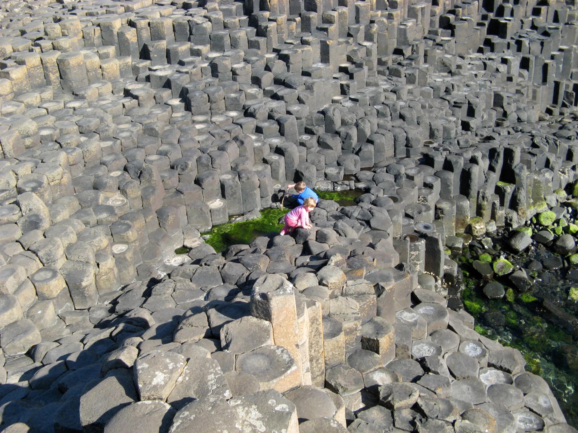
Geometric columns of Causeway Tholeiite at low tide. Credit: Lon D. Abbott and Terri Cook.
Early European geologists found the basaltic columns equally compelling and in need of a scientific explanation. The symmetry of the Causeway’s columns was cited in support of both the Neptunist (igneous rocks precipitate from water) and Vulcanist (igneous rocks are solidified magma) mechanistic worldviews during their fierce philosophical battle in the late 1700s and early 1800s. The outcome, a victory for the Vulcanists, strongly influenced what the science of geology would become (Tomkeieff, 1940). Giant’s Causeway’s role in these discipline-defining battles is a primary reason it was selected by the International Union of Geological Sciences (IUGS) as one of its first 100 Geological Heritage Sites—sites chosen for their international scientific relevance and/or contribution to the development of geological science (IUGS, 2022).
IUGS Geological Heritage Sites
IUGS is a global geoscience organization that brings together over one million geoscientists from 100 countries and establishes key standards for our discipline, from protocols for establishing a geochemical database to the mineralogical classification of igneous rocks; from designating Global Boundary Stratotype Section and Point (GSSP) “golden spikes”—the definitive rock packages that separate time boundaries, such as the Mesozoic from the Cenozoic—to the definitions of chronologic units themselves (such as the recent debate about whether or not to add an Anthropocene Epoch to the geologic timescale).
Figure 2
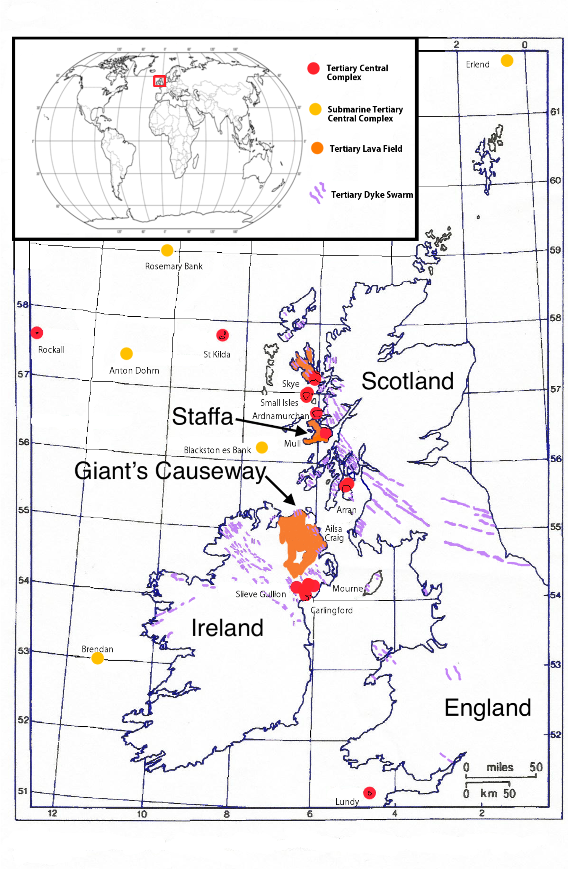
Map of the British Tertiary Volcanic Province, with the various volcanic components shown in colors. The Giant’s Causeway and Staffa are labeled. Credit: Hazel Muzzy, Creative Commons.
In October 2022, after a lengthy process that included convening a panel of 20 geoheritage experts from 13 countries to develop site selection guidelines, and later evaluation, by a separate panel, of 181 candidate sites located in 56 countries, the “First 100” geosites were announced. These sites are world exemplars of geologic features and the locations of profound discoveries about earth history and process (IUGS, 2022). IUGS named the “Second 100” geosites in 2024 and the “Third 100” will be announced in November 2026.
Neptunists Versus Vulcanists
In 1694, medical doctor Thomas Molyneux, who conducted the first petrologic analysis of the Giant’s Causeway basalts, remarked, “this mighty large Pile of Stony Columns . . ., I take not only to be as Remarkable a Natural Curiosity of its sort as this Country affords, but perhaps as may be met with in (all of) Europe” (Tomkeieff, 1940). Although Molyneux’s work was not terribly influential, it placed him in the vanguard of the emerging science of geology, and his admiration for the columns’ symmetry (Fig. 1) foreshadowed the attention it would receive a half century later as an important front in the battle between Neptunists and Vulcanists.
In 1740, the artist Susanna Drury rendered two exquisite lithographs of the Causeway (Fig. 3; Linda Hall Library, 2026) that soon circulated throughout Europe and caught the attention of several early geologists, including the leading proponent of Vulcanism, French geologist Nicolas Desmarest, and German geologist R.E. Raspe. In his 1771 memoir, Desmarest concluded, based solely on Drury’s renderings, that the Causeway basalts were formed from molten lava. Raspe agreed, remarking about the Causeway in 1776, “the regular prismatic columnar black rock or basalt seem . . . to be lavas, which in a hot-fluid state broke their way from underground” (Tomkeieff, 1940).
Figure 3
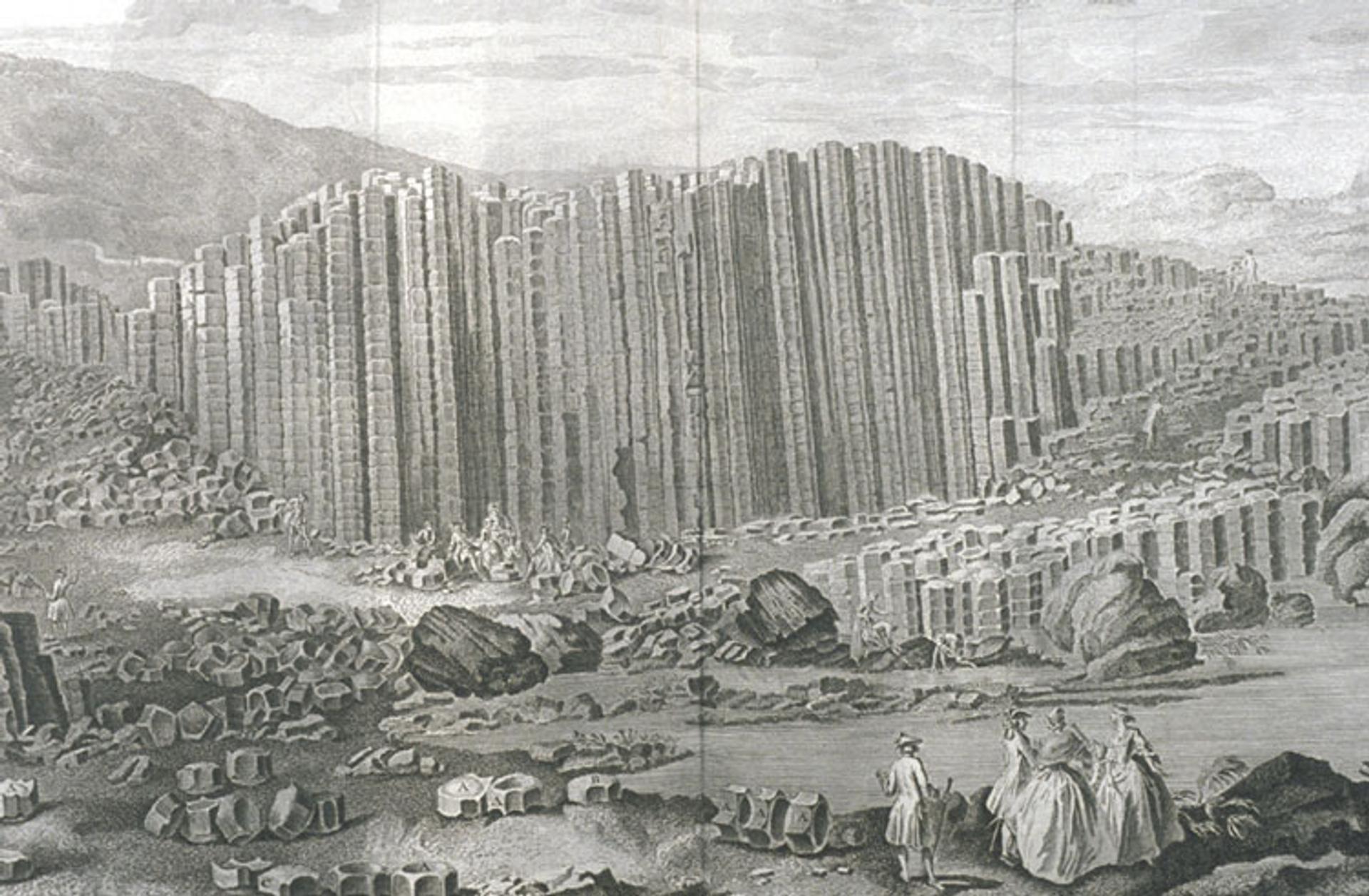
Susanna Drury’s influential lithograph depicting the Giant’s Causeway. Credit: Susanna Drury.
These ideas contradicted those of the Reverend Richard Pococke, a Neptunist who concluded, in a series of papers starting in 1748, that the Causeway’s tiered basalt columns were precipitated from an aqueous solution. The Reverend William Richardson took up the Neptunist baton in 1801, publishing the first of a long series of papers about the Causeway in which he concluded, based on his detailed observations, that the Causeway basalt, like all rocks, according to the Neptunists, were precipitated from seawater. The Neptunists exchanged volleys about the origins of Giant’s Causeway with Vulcanists William Hamilton and John Whitehurst in a series of papers during the early 1800s (Tomkeieff, 1940).
Charles Lyell, in his 1857 Manual of Elementary Geology, highlighted the Giant’s Causeway’s role in the controversy, then mused about the Vulcanist’s ultimate victory: “Considering how complete is the analogy . . . in composition and structure of (basalt) and lavas of active volcanoes, it seems difficult at first to understand how so much doubt could have prevailed for half a century as to whether (basalt) was of igneous or aqueous origin” (Lyell, 1857, p. 486).
Although the formation of columnar basalt from the cooling and contraction of lava has been geologic consensus since the 1850s, the details of how orderly columns emerge from the initially irregular cooling cracks that generate them have continued to receive scrutiny up to recent times. Giant’s Causeway is almost always mentioned as an archetype of the form that modeling results are tested against (e.g., Smalley, 1966; Weaire and O’Carroll, 1983; Budkewitsch and Robin, 1994; Goehring et al., 2009). It was here that S.I. Tomkeieff, who conducted the first modern geologic analysis of the Causeway rocks, borrowed the terms “colonnade” and “entablature” from classical architecture to describe, respectively, the geometric columns and the more slabby basalt that rests atop them (Tomkeieff, 1940; Fig. 4). The terms have since been adopted worldwide to describe this common architecture of thick basalt flows.
Figure 4
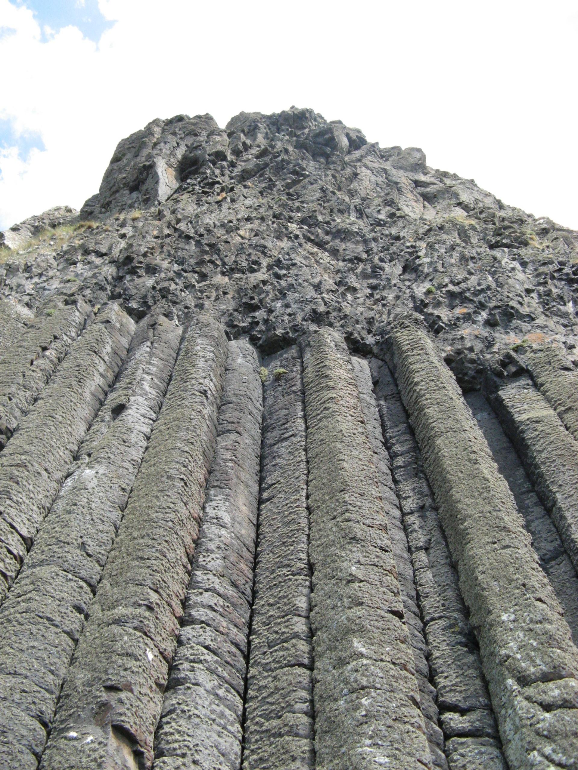
Looking up at one of the Giant’s Causeway’s basalt flows. The elegant columns are called the colonnade and the rubbly material above is called the entablature. These terms, derived from classical architecture, were coined here at the Causeway by S.I. Tomkeieff in 1940 and are now used around the world to describe the two distinct components of thick lava flows. Credit: Lon D. Abbott and Terri Cook.
Northern Ireland’s Antrim Lava Group
The magnificent columns of the Giant’s Causeway form in one unit, known as the Causeway Tholeiite Member, of the larger Paleocene-aged Antrim Lava Group. The Group consists of three formations, the Lower and Upper Basalt Formations, which consist of multiple flows and are up to 531 and 346 m thick, respectively, separated by a 30-m-thick laterite called the Interbasaltic Formation (IBF). The Lower Basalt has been dated at 62.6 ± 0.3 Ma and the Upper at 59.6 ± 0.3 Ma (Ganerød et al., 2010). The IBF records a prolonged volcanic hiatus accompanied by deep weathering to form laterite (Beresford-Browne et al., 2024). The regional hiatus was punctuated by local volcanic episodes, the 61.3 ± 0.3 Ma Tardree Rhyolite in the south and the Causeway Tholeiite in the north (Ganerød et al., 2010). The Causeway Tholeiite is undated, but the underlying laterite contains zircons likely eroded from the Tardree, so it must be younger than the rhyolite (Ganerød et al., 2010).
The Causeway Tholeiite consists of nine separate flows, each of which ponded in a depression, achieving thicknesses to 30 m. That thickness facilitated the slow cooling rate required to form the nearly perfect columns. Geologists recognized the ponding over 100 years ago and have attributed it to infilling of a river valley cut into the Lower Basalt Formation during the prolonged IBF weathering event. But recent detailed mapping led Simms (2021) to conclude that the depression was produced instead by evacuation of the shallow magma chamber that sourced the Causeway Tholeiite itself. Whatever the cause, the Causeway’s nearly one million annual visitors can be thankful it existed, as we likely wouldn’t enjoy such picture-perfect columns if the flows had been thinner (Parkes et al., 2021).
Another long-held interpretation that has recently been questioned is Ireland’s paleoclimate during the Paleocene. The presence of laterite, including aluminum ore that was mined during World War I, has led generations of geologists to conclude that Ireland’s Paleocene climate was hot and wet, typical laterite-forming conditions (Parkes et al., 2021). The Paleocene is known globally for a hot and wet climate, so that conclusion was hardly surprising. But Beresford-Browne and colleagues (2024) inferred from a detailed study of IBF sedimentology and palynology that the Paleocene climate and landscape were not so different from that of today—temperate, with estuaries, swamps, floodplains, chalky and dry soils, lakes, sandbars, fens, and bogs dotting the landscape.
The North Atlantic Igneous Province and the PETM
The Antrim Group is just one of many Paleocene volcanic units that crop out across Great Britain and in nearby submarine exposures that together are called the British Tertiary Volcanic Province (Fig. 2). That province is, in turn, just a subset of the much larger North Atlantic Igneous Province (NAIP), a Large Igneous Province (LIP) that blankets portions of east and west Greenland and the Faroe Islands in thick continental basalt flows and hosts even larger expanses of submarine basalt flows imaged seismically as seaward-dipping reflectors offshore of both Greenland and Norway. All told, the NAIP has a volume of 1.8 million km3 (Eldholm and Grue, 1994), approaching that of other massive LIPs like the Karoo-Ferrar, Siberian Traps, and Deccan Traps. Each of those LIPs is associated with a hothouse climate, oceanic anoxic event (OAE), and mass extinction. So too the NAIP, which erupted during two brief episodes, one between 59 and 62 Ma, coinciding with the end Early Paleocene OAE, and the other between 54 and 57 Ma, linked to the Paleocene-Eocene Thermal Maximum (PETM) hothouse and a mass extinction of marine benthic organisms (Courtillot and Renne, 2003).
Many authors have argued that eruption of the NAIP triggered the PETM via a massive carbon release to the atmosphere through a combination of direct volcanic outgassing, combustion of abundant organic matter contained in the sediments intruded by the NAIP sills, and thermal destabilization of frozen methane hydrates beneath the seafloor. This latter would have released massive amounts of methane, an especially potent greenhouse gas (Courtillot and Renne, 2003).
Although there are plenty of ways the NAIP could inject carbon into the atmosphere, many authors have concluded the pace of emission was too slow to account for the 0.3–1.1 PgC/yr computed for the PETM. But recent modeling has shown that the NAIP was up to the task, capable of releasing carbon at a rate of 0.2–0.5 PgC/yr, fast enough to trigger the <20,000 years of 4–5 °C warming documented at the PETM (Jones et al., 2019, and references therein).
Hundreds of Years of Geotourism
Giant’s Causeway has been a geotourism destination for literally hundreds of years. The alternate legend, that Finn McCool built the causeway for love, is little known today but it was the version commonly told by tour guides in the 1700s and 1800s (National Trust, 2026).
Today, Giant’s Causeway is Northern Ireland’s #1 tourist attraction. It is globally significant to geologists because of both the basalt columns and the associated paleosols. Without the geology, it’s highly unlikely this spot would attract anywhere near as many visitors. Despite the centrality of geology to the Causeway’s appeal, a 2007 survey revealed that most visitors were more familiar with the concept of biodiversity than they were with geodiversity (Crawford and Black, 2011). Parkes et al. (2021) noted that the Giant’s Causeway’s fame illustrates that volcanic geoheritage possesses significant public appeal. Nevertheless, they lamented that the site’s volcanic fame overshadows its other worthy geoheritage attributes, including its rich history of iron and aluminum mining. They expressed disappointment that, in contrast to the international attention paid to the columns, there has been little interest in that mining history.
IUGS geoheritage sites, UNESCO global geoparks, and geologically rich World Heritage Sites like Giant’s Causeway all highlight Earth’s magnificent geodiversity, which forms the foundation on which the planet’s biodiversity is built. Human life and civilization rely on this combination of geodiversity and biodiversity. As geoscientists, we can play a constructive role in raising public awareness of geoheritage and geoconservation, helping elevate its perceived importance to the same level as public recognition of the urgent need to protect biodiversity. Doing so will help human civilization thrive for generations to come.
References Cited
- Beresford-Browne, A., Jolley, D., Millett, J., Stevenson, C., Watt, S., Raine, R., and Carter, E., 2024. Depositional system and plant ecosystem responses to long-term low tempo volcanism, the Interbasaltic Formation, Antrim Lava Group, in Kilhams, B., Holford, S., Gardiner, D., Gozzard, S., Layfield, L., McLean, C., Thackrey, S., and Watson, D., eds., The Impact of Igneous Systems on Sedimentary Basins and their Energy Resources: Geological Society of London Special Publication 547, p. 483–509, https://doi.org/10.1144/SP547-2023-75.
- Budkewitsch, P., and Robin, P.-Y., 1994, Modelling the evolution of columnar joints: Journal of Volcanology and Geothermal Research, v. 59, no. 3, p. 219–239, https://doi.org/10.1016/0377-0273(94)90092-2.
- Courtillot, V.E., and Renne, P.R., 2003, On the ages of flood basalt events: Comptes Rendus Geoscience, v. 335, no. 1, p. 113–140, https://doi.org/10.1016/S1631-0713(03)00006-3.
- Crawford, K.R., and Black, R., 2011, Visitor understanding of the geodiversity and the geoconservation value of the Giant’s Causeway World Heritage Site, Northern Ireland: Geoheritage, v. 4, no. 1–2, p. 115–126, https://doi.org/10.1007/s12371-011-0049-6.
- Eldholm, O., and Grue, K., 1994, North Atlantic volcanic margins: Dimensions and production rates: Journal of Geophysical Research: Solid Earth, v. 99, p. 2955–2968, https://doi.org/10.1029/93JB02879.
- Ganerød, M., Smethurst, M.A., Torsvik, T.H., Prestvik, T., Rousse, S., McKenna, C., Van Hinsbergen, D.J.J., and Hendriks, B.W.H., 2010, The North Atlantic Igneous Province reconstructed and its relation to the Plume Generation Zone: The Antrim Lava Group revisited: Geophysical Journal International, v. 182, no.1, p. 183–202, https://doi.org/10.1111/j.1365-246X.2010.04620.x.
- Goehring, L., Mahadevan, L., and Morris, S.W., 2009, Nonequilibrium scale selection mechanism for columnar jointing: Proceedings of the National Academy of Sciences, v. 106, no. 2, p.387–392, https://doi.org/10.1073/pnas.0805132106.
- IUGS, 2022, The First 100 IUGS Geological Heritage Sites: Spain, International Union of Geological Sciences, 153 p.
- Jones, S.M., Hoggett, M., Greene, S.E., and Jones, T.D., 2019, Large Igneous Province thermogenic greenhouse gas flux could have initiated Paleocene–Eocene Thermal Maximum climate change: Nature Communications, v. 10, https://doi.org/10.1038/s41467-019-12957-1.
- Linda Hall Library, 2026, Susanna Drury, the Causeway, and the Encyclopédie, 1768: https://www.lindahall.org/experience/digital-exhibitions/vulcans-forge-and-fingals-cave/section-vi/16-susanna-drury-causeway-encyclopedie-1768/ (accessed April 2026).
- Lyell, C., 1851, A Manual of Elementary Geology: London, John Murray, 512 p.
- National Trust, 2026, History of Giant’s Causeway: https://www.nationaltrust.org.uk/visit/northern-ireland/giants-causeway/history-of-giants-causeway (accessed April 2026).
- Parkes, M., Gatley, S., and Gallagher, V., 2021, Old volcanic stories—Bringing ancient volcanoes to life in Ireland’s geological heritage sites: Geosciences, v. 11, no. 2, https://doi.org/10.3390/geosciences11020052.
- Simms, M.J., 2021, Subsidence, not erosion: Revisiting the emplacement environment of the Giant’s Causeway, Northern Ireland: Proceedings of the Geologists’ Association, v. 132, no. 5, p. 537–548, https://doi.org/10.1016/j.pgeola.2021.07.001.
- Smalley, I.J., 1966, Contraction crack networks in basalt flows: Geological Magazine, v. 103, no. 2, p. 110–114, https://doi.org/10.1017/S0016756800050482.
- Tomkeieff, S.I., 1940, The basalt lavas of the Giant’s Causeway district of Northern Ireland: Bulletin of Volcanology, v. 6, no. 1, p. 89–143, https://doi.org/10.1007/BF02994875.
- Weaire, D., and O’Carroll, C., 1983, A new model for the Giant’s Causeway: Nature, v. 302, no. 5905, p. 240–241, https://doi.org/10.1038/302240a0.
CITATION: Moore, J.R., et al., 2026, Tower in motion: Resonance mode analysis of Devils Tower, Wyoming, USA: GSA Today, v. 36, p. 4–9, https://doi.org/10.1130/GSATG635A.1.
© 2026 The Author. Gold Open Access: This paper is published under the terms of the CC-BY-NC license. Printed in the USA.