
Insights into Widespread Landsliding in Southern Appalachia from Hurricane Helene
Lauren Schaefer et al.

In this article
Authors
Lauren Schaefer
U.S. Geological Survey, Geologic Hazards Science Center, Golden, Colorado 80401, USA
Francis Rengers
U.S. Geological Survey, Geologic Hazards Science Center, Golden, Colorado 80401, USA
Benjamin Mirus
U.S. Geological Survey, Geologic Hazards Science Center, Golden, Colorado 80401, USA
Liam Toney
U.S. Geological Survey, Geologic Hazards Science Center, Golden, Colorado 80401, USA
Kate Allstadt
U.S. Geological Survey, Geologic Hazards Science Center, Golden, Colorado 80401, USA
Richard Wooten
North Carolina Geological Survey, Asheville Regional Office, Swannanoa, North Carolina 28778, USA
Patrick Moore
National Oceanic and Atmospheric Administration, National Weather Service Greenville-Spartanburg Office, Greer, South Carolina 29651, USA
Paula Burgi
U.S. Geological Survey, Geologic Hazards Science Center, Golden, Colorado 80401, USA
Anne Witt
Virginia Department of Energy, Geology and Mineral Resources Program, Charlottesville, Virginia 22903, USA
Eric Bilderback
U.S. Geological Survey, Geologic Hazards Science Center, Golden, Colorado 80401, USA
Jennifer Bauer
Appalachian Landslide Consultants PLLC, Asheville, North Carolina 28813, USA
David Korte
North Carolina Geological Survey, Asheville Regional Office, Swannanoa, North Carolina 28778, USA
Matthew Crawford
Kentucky Geological Survey, University of Kentucky, Lexington, Kentucky 40506
Abstract
Between 23 and 27 September 2024, antecedent rain followed by Hurricane Helene produced one of the most damaging weather events in southern Appalachia history. The back-to-back storm events resulted in a maximum cumulative rainfall of 848 mm and hurricane-force wind gusts over 170 km/h in western North Carolina, eastern Tennessee, and southwestern Virginia. The resulting regional flooding, landslides, and tree blowdown caused over 100 fatalities, damaged or destroyed critical infrastructure and thousands of structures, and severed connectivity across the region. Over the next several weeks, a multi-agency landslide response produced a rapid hazard assessment and mapped 2217 landslides, 55% of which damaged infrastructure or property. Orographic uplift enhanced rainfall, resulting in concentrated landsliding along the ~250 km swath of the Blue Ridge escarpment in western North Carolina. Landslides initiated predominantly on windward-facing (southeast-facing) slopes, and localized clustering of initiation points indicated a strong influence of hillslope-scale meteorological and geomorphic factors. Many shallow landslides mobilized into larger, highly mobile, and damaging debris flows that graded into floods. Here, we put our preliminary observations in the context of historical storm-driven landslide events and open new avenues for investigating the nature and extent of landslides and their effects in southern Appalachia and similar environments.
* lschaefer@usgs.gov
CITATION: Schaefer, L.N., et al., 2025, Insights into widespread landsliding in southern Appalachia from Hurricane Helene: GSA Today, v. 36, p.4–11, https://doi.org/10.1130/GSATG625A.1.
© 2025 The Authors. Gold Open Access: This paper is published under the terms of the CC-BY-NC license. Printed in the USA.
Introduction
The southern Appalachian Mountains are characterized by steep, rugged terrain and complex geology. The Blue Ridge escarpment forms a notable mountain front running from northern Georgia through western Virginia (Fig. 1A; Spotila et al., 2004). The bedrock geology of the Blue Ridge includes highly deformed and metamorphosed rock including metasedimentary slate, phyllite, marble, schist, and gneiss, meta-igneous amphibolite and greenstone, granitic gneiss, and unmetamorphosed granitic rock, the oldest of which formed between 1.8 and 1 Ga (Wooten et al., 2016). The associated steep topography of the Blue Ridge escarpment, with abundant faults and fracture zones, is prone to a variety of landslide types (Hill et al., 2024). Debris flows, some with markedly high velocity and long runout, have resulted in numerous fatalities and destruction across the region (Latham et al., 2007; Wooten et al., 2022; Wieczorek et al., 2000, 2009). Extreme rainfall–triggered landsliding events with broad and severe consequences occur every 9 to 25 yr, with hundreds to thousands of landslides, respectively (Wooten et al., 2016). Notable examples include back-to-back tropical cyclones in July 1916 and August 1940, Hurricanes Frances and Ivan in 2004 (Fig. 2), and Hurricane Camille in 1969.
Figure 1
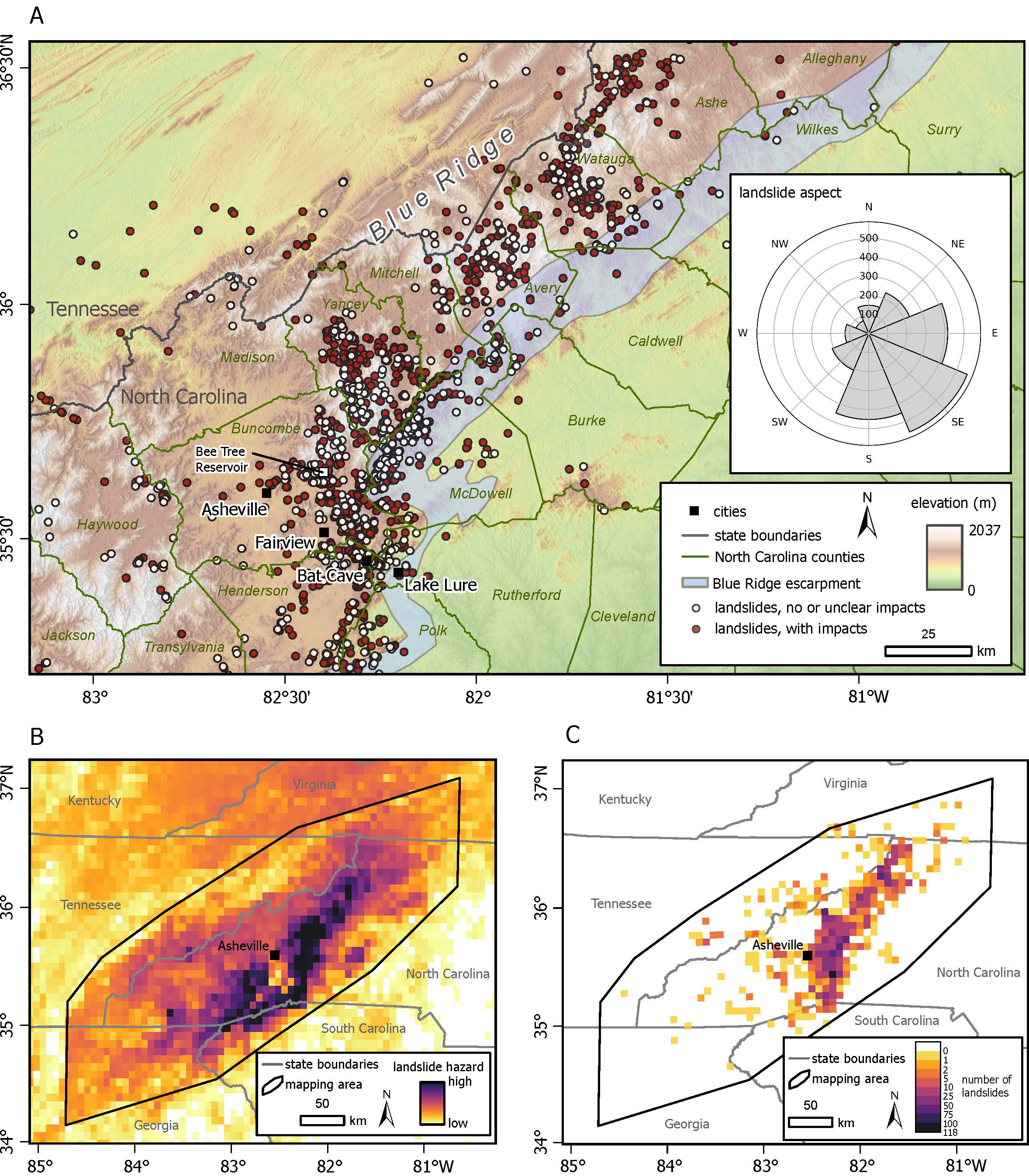
Hurricane Helene landslides and landslide hazard map created during the emergency response. (A) Area of concentrated landsliding (Burgi et al., 2025) and geographic locations on top of U.S. Geological Survey (USGS) 10-m-resolution digital elevation model. Inset shows graph of landslide aspect, predominately on windward-facing (southeast-facing) slopes. Blue Ridge escarpment is from Latham et al. (2007). (B) Relative landslide hazard map based on early estimates of Hurricane Helene precipitation combined with USGS landslide susceptibility proxies (Martinez et al., 2024). Emergency mapping area, shown with black outline, was based on this hazard map. Cell size is 6.5 km2. (C) Number of landslides mapped in each 6.5 km2 cell.
Compared to these historical events, Hurricane Helene in 2024 was exceptional because of its large spatial extent, record-breaking cumulative rainfall amounts, and widespread landslide occurrence (Fig. 2). On the evening of 26 September, the center of circulation of Hurricane Helene made landfall over the Florida Big Bend region as a category 4 hurricane, but scattered convection had already been producing rain in parts of southern Appalachia since 23 September (Fig. 3). From the early morning of 25 September, tropical moisture that had separated from the circulation associated with Hurricane Helene interacted with a meteorological boundary to produce heavy rain prior to the arrival of the tropical cyclone, called a predecessor rain event (PRE; Cote, 2007; Galarneau et al., 2010). The PRE was followed by the Helene tropical system as the storm moved north through Georgia and into Tennessee. The combination of the antecedent convection, the PRE, and Hurricane Helene between 23 and 27 September produced nearly continuous rain and wind gusts up to hurricane force (wind speeds exceeding 119 km/h) in the southern Blue Ridge (Fig. 3; Hagen et al., 2025).
In western North Carolina, the storm caused over 100 fatalities along with widespread, catastrophic damage due to flooding and landsliding (Figs. 1 and 4; Hagen et al., 2025). Herein, we provide some scientific insights to inform the broader community about storm-triggered landsliding in this region.
Response Efforts and Data
Together with state, federal, and local partners, the U.S. Geological Survey (USGS) activated their landslide emergency response team (Landslide Assessments, Situational awareness and Event Response research [LASER]) to support partner agencies, emergency responders, and search and rescue efforts. LASER coordinated a large interagency effort, which included rapid remote, aerial, and field mapping of landslides and impacts, hazard modeling and assessments, daily situational reports relaying landslides of concern, and educational and outreach material development (Allstadt et al., 2024, 2025; Rengers and Mirus, 2024; USGS, 2024a).
Efforts to assess the extent and severity of landsliding were initially hampered because mostly cloudy conditions affected aerial and satellite imagery during the first week of October (Fig. 4E; Fig. S1 in the Supplemental Material7). During this period of uncertainty, preliminary relative landslide hazard models were developed to assess where landslides may be concentrated (Fig. 1B). These models used preliminary estimates of precipitation based on radar and rain gage data provided by the National Weather Service (NWS) Greenville-Spartanburg Office combined with USGS landslide susceptibility proxies from Mirus et al. (2024) (see Martinez et al., 2024). The models were provided to emergency responders for early situational awareness and used to prioritize remote mapping and field reconnaissance. Final quality-controlled precipitation estimates used in this study (Fig. 3B) were not available until April 2025 (for preliminary and final rainfall totals, refer to Martinez et al., 2024).
As part of the response, an interagency group of 31 participants from 10 agencies rapidly mapped landslide point locations and impacts between 28 September and 23 October (Figs. 1A and 1C). These results were shared publicly and updated in real time via a Web-based dashboard map (USGS, 2024b). Data used to inform landslide mapping included satellite imagery, oblique aerial photos, media and social media reports, North Carolina Department of Transportation reports, personal communications (e.g., from emergency managers, residents), and field observations from partners on the ground (refer to details in Burgi et al., 2025). During the response, satellite normalized difference vegetation index (NDVI) change maps, a measure of vegetation damage, were used to highlight debris-flow paths and aided mapping efforts (Fig. 4G). After this initial response period, the USGS conducted a review and quality assessment of the mapped landslides, providing the initiation (headscarp) point location and a simplified impact classification for a total of 2217 landslides (Fig. 1; Burgi et al., 2025), which we analyze herein. It was not possible to capture all landslide features or details during the response efforts due to factors such as imagery with poor lighting and/or low spatial resolution, or landslide source areas obscured by dense canopy.
We calculated the elevation, slope angle, and slope aspect for each initiation location using the USGS 10-m-resolution digital elevation models (DEMs; USGS, 2019). We also analyzed storm timing and precipitation patterns (Fig. 3C; data from NOAA, 2020) using NWS geospatial estimates of storm precipitation totals, as well as rainfall time-series data from 384 weather stations and wind gust data from 254 stations using FlowAlert (King et al., 2024). The propensity for shallow landsliding in this region has been linked to both rainfall intensity and event accumulation (e.g., Wieczorek et al., 2009); thus, we examined 60 min and 24 h intensities as well as cumulative rainfall between 23 and 27 September 2024.
Figure 2
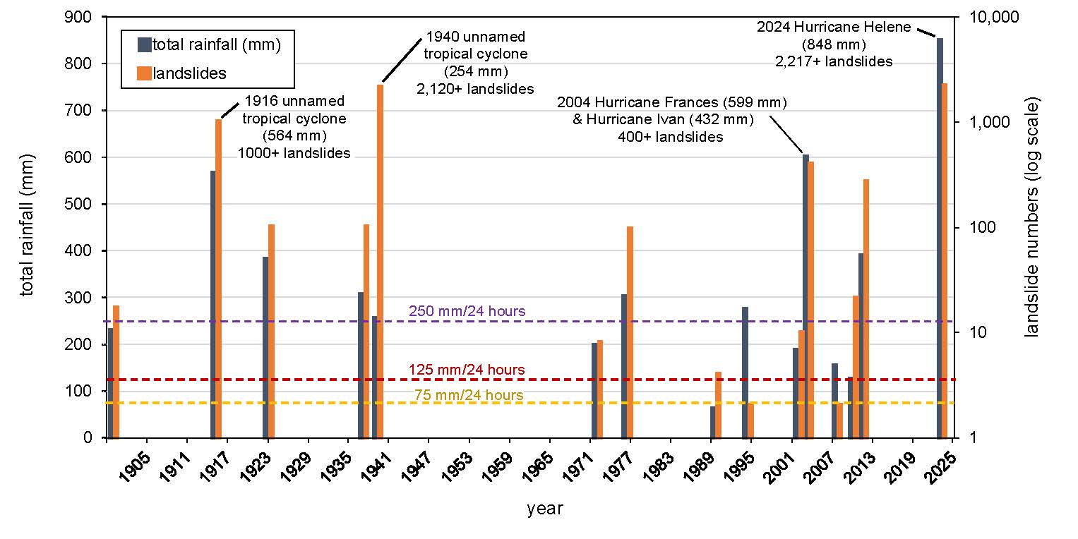
Landslides associated with storm events in western North Carolina. Data for all events excluding Hurricane Helene are from Wooten et al. (2016) and references therein. Back-to-back storm events, such as those which occurred during Hurricane Helene, are labeled. Dashed lines show 24 h rainfall thresholds: yellow line at 75 mm (3 inches) indicates the threshold for landslides on some modified slopes (Wooten et al., 2017); red line at 125 mm (5 inches) indicates the threshold for landslides on unmodified (forested) slopes; and purple line at 250 mm (10 inches) indicates the threshold for widespread landsliding (based on Appalachia region; Eschner and Patrick, 1982).
Storm Timing and Precipitation Patterns
The storm was characterized by a long period of heavy rain with bursts of high intensity across a large region (Fig. 3C), accompanied by maximum wind gusts that reached tropical storm to hurricane-force wind speeds throughout the mountains (Fig. 3B). The storm sequence started with antecedent rain occurring from 17:00 h on 23 September (note all times are in Eastern Daylight Time), followed by the PRE and Hurricane Helene occurring from ~5:00 to 9:00 h on 25 September to 16:00 h on 27 September (Fig. 3C). Prior to Hurricane Helene making landfall in Florida (23:10 h on 26 September; Fig. 3A), the region had a median rainfall of 111 mm, considering all gages analyzed, with a maximum of 486 mm at the FW5271 Hendersonville gage. The peak 60 min rainfall intensity of 79.7 mm/h at the EW5713 Asheville gage at 18:33 h on 25 September exceeded the 100 yr rate (79 mm/h) at that location (NOAA, 2020).
Rainfall waned in intensity several times; however, there was no distinct break between the beginning of the PRE and the arrival of the tropical cyclone (Fig. 3C). During Helene, rainfall intensities continued to increase, peaking at ~08:45 h on 27 September and ending by ~16:00 h the same day. The peak 60 min rainfall rate of 89.4 mm/h observed at the FW5271 Hendersonville gage was close to the 100 yr rainfall (92 mm/h) for that location (NOAA, 2020). The 24 h rainfall intensity peaked at 13:17 h on 27 September with 21.79 mm/h at the BSKN7 Busick RAWS gage; this approached the peak of 23.5 mm/h recorded at Altapass during the July 1916 event (Wieczorek et al., 2009) and exceeded the 1000 yr recurrence interval (14 mm/h) at this location (NOAA, 2020). Between 23 and 27 September, gages showed a median rainfall total of 218 mm (excluding gages that recorded 0 mm) and a maximum of 848 mm at the FW5271 Hendersonville gage, but storm totals in many locations may be underestimated because 182 stations lost power between 09:16 h on 26 September and 16:00 h on 27 September (NOAA, 2020).
Figure 3
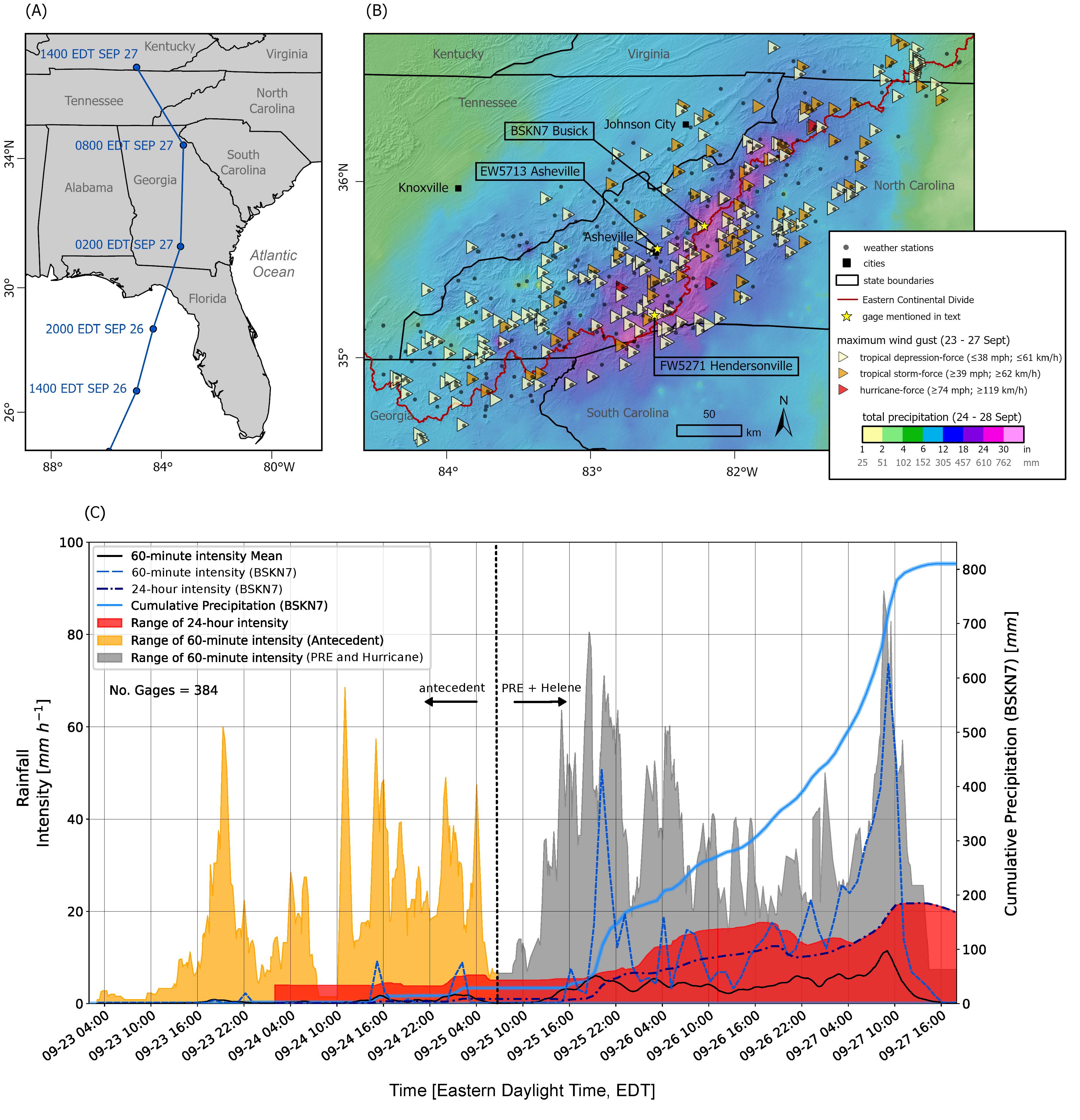
Precipitation and wind gusts in southern Appalachia before and during Hurricane Helene. (A) Storm best track for Hurricane Helene. Data are from National Oceanic and Atmospheric Administration (NOAA) National Hurricane Center (Hagen et al., 2025). (B) Final gridded estimates of rainfall based on radar, gage data, and ground-truth reports (Martinez et al., 2024), and maximum wind gusts measured on weather stations. Weather stations shown in part B were those used to obtain rainfall and wind data for the storm timing and precipitation pattern analysis herein. (C) Time series showing rainfall intensity (60 min and 24 h) as well as cumulative rainfall from the BSKN7 gage (NOAA, 2020). The intensities are shown as a range with the highest and lowest rainfall from each of 384 gages at each minute. PRE—predecessor rain event.
Landslide Characteristics and Impacts
Most landslides occurred in western North Carolina, concentrated in a north-south trend east of Asheville, North Carolina, and in a southwest-northeast trend along the Blue Ridge (Fig. 1A), corresponding to locations where orographic uplift enhanced rainfall (Fig. 3B). We noted a predominance (64%) of landslides initiated on southeast-facing slopes (azimuths between 68° and 202°; Fig. 1A, inset). Landslides initiated over a wide range of elevations (200–1800 m above sea level), primarily on slopes between 15° and 35° (Figs. S2A and S2B), and in colluvial hollows (i.e., convergent landforms; Fig. S2D). Landslides initiated in colluvium or at the colluvium-bedrock boundary, some of which left large scars that excavated soil and regolith to expose fractured, weathered bedrock (Fig. 4E). While previous studies have underlined the importance of bedrock structural discontinuities, differential weathering, and subsurface morphologies on landslide and debris-flow initiation (e.g., Hill et al., 2024; Wooten et al., 2016), further field observations are required to assess the importance of these various factors during Hurricane Helene.
At the time of publication, there are 107 verified Hurricane Helene–related fatalities in North Carolina reported by the North Carolina Department of Health and Human Services, and 24 of these deaths have been attributed directly to landslides (Hagen et al., 2025). Landslides blocked and undermined roads and railroads and damaged and destroyed buildings (Figs. 4A, 4B, and 4F); of the 2217 mapped landslides considered herein, 1227 (55%) directly impacted infrastructure or property (Fig. 1A). Many residents were isolated as road damage and tree blowdown severed transportation, power, and communication across the region. Debris and sediment from landslides and flooding flowed into reservoirs, resulting in debris jams, high turbidity, and degraded water quality (Fig. 4C).
Many landslides observed during field and remote efforts were debris flows that initiated as one or more shallow landslides or, less commonly, were due to mobilization of soil by overland flow. Some of the largest and most damaging debris flows were fed by multiple upslope source areas, where they initiated as shallow landslides and then traveled for several kilometers and entrained channel and bank materials, further augmenting the destructive flooding. For example, one of the deadliest single debris flows in Flat Creek, which caused 13 fatalities in Fairview, initiated from at least five distinct source areas that converged into a large debris flow with multiple surges that destroyed 14 structures ~2.5 km downstream from the most upstream source area (Figs. 4F and 4G; Medina, 2024). There were also many shallow landslides that did not mobilize into channelized debris flows but were still highly destructive (Fig. 4A). Many slides originated from fill or cut slopes along roads, rails, trails, and other modified slopes (Fig. 4B), which may reflect the influence of human alteration of slopes and drainages (e.g., Collins, 2008; Wooten et al., 2017). In addition to landslides, tree blowdown and vegetation damage were also widespread (Figs. 4D and 4H; Fig. S3). In many areas, winds were strong enough to rip tree root balls from the ground (Fig. 4D).
Figure 4
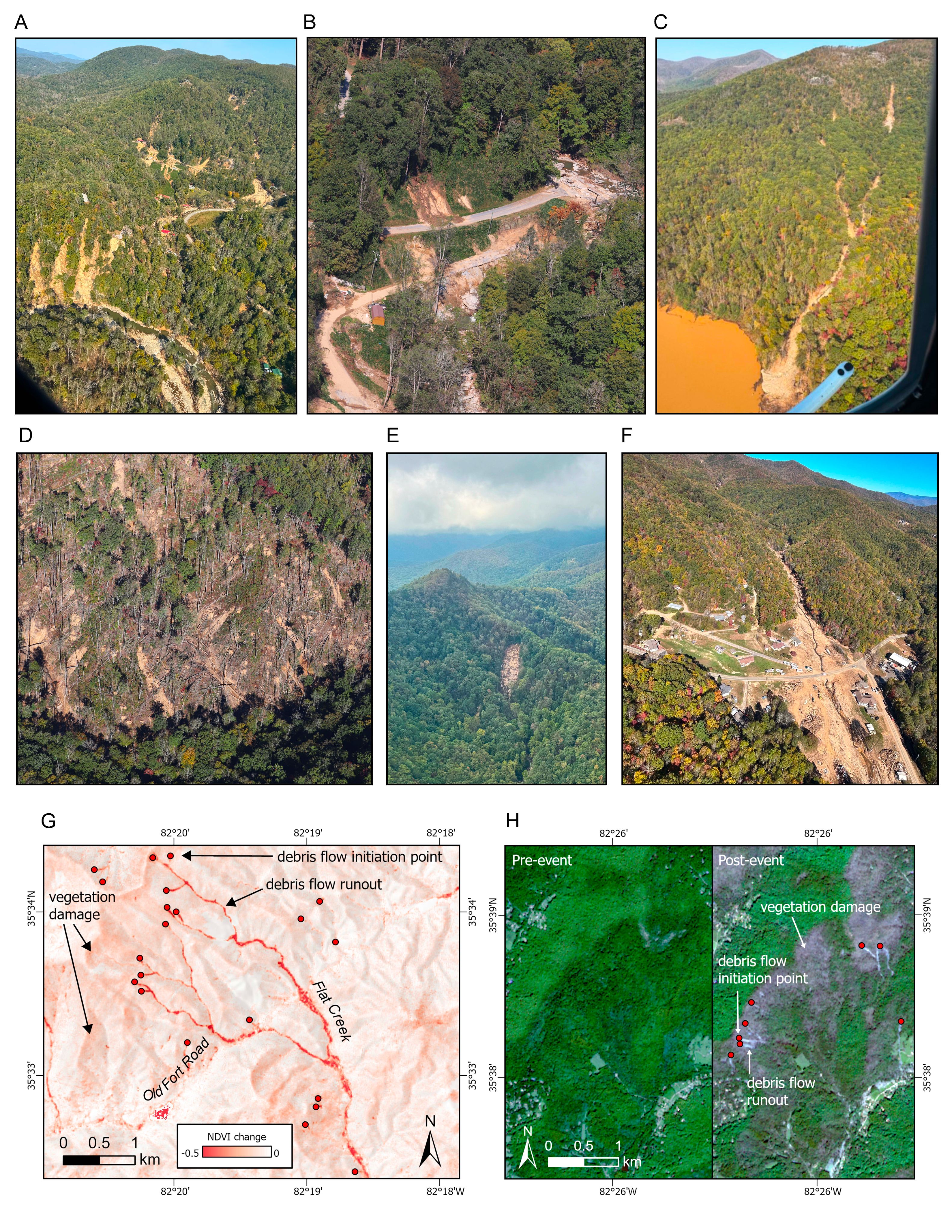
Oblique aerial photos (Allstadt et al., 2024; Rengers and Mirus, 2024) and satellite images of landslides and their impacts. (A) Multiple landslides in Bat Cave, an area which experienced a high density of landsliding on the order of 15 landslides/km2. Photo by U.S. Geological Survey (USGS)/K. Allstadt. (B) Example of landslide and flood damage to roads. Photo by USGS/S. Slaughter. (C) Debris flow that flowed into Bee Tree Reservoir, a main water supply to the City of Asheville and parts of Buncombe and Henderson Counties. Orange water color indicates high turbidity of the reservoir. Photo by USGS/K. Allstadt. (D) Debris flows among tree blowdown and other vegetation damage. Rounded patches of soil show where windthrown trees ripped root balls out of the ground. Photo by USGS/S. Slaughter. (E) Landslide that excavated soil and regolith to expose fractured, weathered bedrock. Note low cloud cover, which prevented remotely sensed imagery mapping in early October. Photo by USGS/B. Mirus. (F) Lower portion of long-runout debris flow along Flat Creek that caused 13 fatalities and destroyed several homes and roads and augmented flooding downstream. Photo by USGS/J. Godt. (G) Sentinel-2 normalized difference vegetation index (NDVI) image highlighting multiple source areas that converged into Flat Creek and traveled downstream (south in image), producing a long-runout debris flow. Negative values highlight areas where vegetation was present pre-event and was subsequently removed or damaged postevent. (H) Pre-event (22 September 2024) and postevent (12 October 2024) red-green-blue (RGB) Sentinel-2 imagery highlighting debris flows among areas of extensive vegetation damage and tree blowdown.
Implications for Landslide Hazards
The extreme nature of Hurricane Helene, with thousands of landslides and widespread devastation over a broad swath of southern Appalachia, may raise concerns of a trend toward more large-scale damaging storms for the region (Fig. 2). Long-term records of daily rainfall demonstrate an increasing trend in the cycles between protracted dry periods to years with extreme rainfall (Laseter et al., 2012; Burt et al., 2017). Although the short-term influence of climatic extremes can be characterized (Mirus et al., 2019), longer-term projected increases in the frequency of landslide-triggering storms may be overshadowed by the slow pace of diffusive sediment transport processes that “reload” hillslope hollows over the time scale of landscape evolution (Parker et al., 2016). Hurricane Helene created numerous landscape disturbances, and in general, we may anticipate exacerbated landslide hazards where source areas were not fully excavated, in oversteepened areas above new landslide scarps, where slopes experienced some deformation and cracking but did not yet fail, where root reinforcement was reduced, where undercutting or oversteepening may have occurred due to flood erosion, or in road cuts and modified slopes with lower established rainfall thresholds (e.g., Wooten et al., 2016, 2017).
Although many factors are at play in controlling storm-driven landslide location, the overall pattern for landsliding during Hurricane Helene appears to have been strongly influenced by total storm rainfall extents (Fig. S4). Approximately 95% of mapped landslides occurred in areas that received cumulative rainfall of 254 mm (10 inches) or more, and no landslides were mapped in areas that received 127 mm (5 inches) or less (Fig. S4). This result underscores previously reported 24 h rainfall thresholds required to initiate widespread landsliding in the southern Appalachians (Eschner and Patrick, 1982; Witt, 2005; Wooten et al., 2016), and the broad utility of the current guidelines used operationally by NWS for alerting thresholds in this region (Wooten et al., 2017). We found that landslides were prevalent near most gages with 24 h rainfall intensities ≥12 mm/h in steep mountainous areas, close to the minimum 24 h threshold of 14 mm/h required to trigger debris flows in the Blue Ridge of central Virginia (Fig. S6; Wieczorek et al., 2009). Several areas with lower 24 h rainfall intensities also experienced landsliding. Thus, we expect that in addition to rainfall patterns, landslide initiation or lack of initiation may also have been influenced by finer-scale structures, differential weathering, and bedrock geologic variability (Hill et al., 2020; Wooten et al., 2016), forest cover and spatial vegetation patterns (Hales et al., 2009), and/or recent history of debris flows that may have depleted sediment from hillslope hollows and channels (Parker et al., 2016; Wooten et al., 2016).
Although landsliding was regionally extensive, we also found evidence of smaller-scale spatial clustering and preferential landslide initiation on windward-facing (southeast-facing) slopes (Fig. S5). Considering a 6.5 km2 cell size from our relative landslide hazard model, the maximum density was 2.7 landslides/km2 (Fig. 1C), but with a 1 km2 cell size, this increases to a maximum of 15 landslides/km2 (e.g., Bat Cave area; Fig. 4A), emphasizing the uneven spatial distribution of landsliding at smaller spatial scales. Although previous storm-driven landsliding shown in Figure 2 does not account for variables such as spatial footprint, susceptibility, or geology, all of which would greatly affect number of landslides, in general, historical patterns indicate an exponential relationship between rainfall totals and number of landslides. Given the high rainfall totals during Hurricane Helene, we thus can anticipate that the total number of landslide initiation points may increase substantially with the acquisition of high-resolution topographic data, poststorm high-resolution leaf-off orthophotography, and ongoing field mapping efforts.
The preliminary landslide hazard models (Fig. 1B; Martinez et al., 2024) correctly captured much of the area that experienced heavy landsliding in regions of high susceptibility as determined by Mirus et al. (2024) (see Fig. S4) and were exceptionally useful for guiding early response efforts when limited cloud-free satellite imagery was available. In general, the models correctly estimated high concentrations of landsliding to the north of the Blue Ridge escarpment and east of Asheville and lower concentrations to the south of the Blue Ridge escarpment (Fig. 1). The models overestimated landsliding in southern portions of the Blue Ridge to the west of Asheville where preliminary NWS precipitation estimates were high but landslide impacts were sparse (Fig. 1; Fig. S4). Additional detailed landslide mapping and analysis of rainfall temporal and spatial variability can help to clarify discrepancies between the model and landslide occurrence.
Like landsliding, tree blowdown was widespread during Hurricane Helene, occurring preferentially on windward-facing (southeast-facing) slopes (Fig. 4H; Fig. S3). Estimates of forest damage from the U.S. Forest Service (USFS, 2024) indicate that ~580 km2 of forest experienced large continuous areas of entirely or mostly blown down and broken trees, and 2400 km2 experienced severe or mixed damage including moderate to major downed wood accumulation (Fig. S3). The widespread tree blowdown and resulting alteration of soil structure, root reinforcement, and hydrology may affect hillslope stability, potentially encouraging future shallow landsliding (Sidle et al., 2006; Ulanova, 2000; Mauri and Tarolli, 2023), although the time scale of this disturbance-recovery cycle for southern Appalachia remains unclear. Widespread tree mortality also increases fuel loading on forest floors that could enhance burn severity for future wildfires (e.g., Kulakowski and Veblen, 2007).
The widespread impacts of Hurricane Helene confirm the significance of sustained heavy rainfall on landsliding in southern Appalachia and highlight the role of wind in exacerbating this deadly and destructive hazard. Our assessments, modeling, and response efforts provided timely analysis and communication to aid emergency responses, and these new data can also provide a foundation for additional research to help inform future landslide loss reduction in the region.
1 Supplemental Material. Figures S1–S6. Additional details about the response timeline and landslide characteristics. Please visit https://doi.org/10.1130/GSAT.S.30888593 to access the supplemental material; contact editing@geosociety.org with any questions.
Acknowledgments
We acknowledge the widespread devastation and disruption Hurricane Helene caused across the southeastern United States. We thank the many participants who contributed to our landslide response and mapping effort. Any use of trade, firm, or product names is for descriptive purposes only and does not imply endorsement by the U.S. government.
References
- Allstadt, K.E., Godt, J.W., and Slaughter, S.L., 2024, Oblique Aerial Photographs from October 13 and 17, 2024, of Landslides and Flooding Caused by Hurricane Helene (Ver. 1.1, March 2025): U.S. Geological Survey data release, https://doi.org/10.5066/P1C5W3PQ.
- Allstadt, K.E., McBride, S.K., Godt, J.W., Slaughter, S.L., Baxstrom, K.W., Sobieszczyk, S., and Stull, A., 2025, Preliminary Field Report of Landslide Hazards Following Hurricane Helene: U.S. Geological Survey Open-File Report 2025-1028, 15 p., https://doi.org/10.3133/ofr20251028.
- Burgi, P.M., Toney, L.D., Collins, E.A., Murphy, C.R., Ellison, S.M., Schmitt, R.G., Allstadt, K.E., Bedinger, E.C., Belair, G.M., Bilderback, E.L., Dunlap, L.R.C.C., Cattanach, B., Crawford, M.M., Einbund, M.M., Fitzpatrick, F.A., Frost, D.J., Grant, A.R.R., Hageman, S.J., Hartman, C., Heckert, A.B., Hoch, O.J., Johnson, B., Jones, E.S., Jurgevich, J., Karantanellis, E., Korte, D., Martinez, S.N., Merschat, A.J., Miles, C.P., Sas, R., Schaefer, L.N., Scheip, C., Soobitsky, R., Trantham, B., and Witt, A., 2025, Preliminary Landslide Inventory for Landslides Triggered by Hurricane Helene (September 2024): U.S. Geological Survey data release, https://doi.org/10.5066/P14CHGKS.
- Burt, T.P., Miniat, C.F., Laseter, S.H., and Swank, W.T., 2017, Changing patterns of daily precipitation totals at the Coweeta Hydrologic Laboratory, North Carolina, USA: International Journal of Climatology, v. 38, no. 1, p. 94–104, https://doi.org/10.1002/joc.5163.
- Collins, T.K., 2008, Debris flows caused by failure of fill slopes: Early detection, warning, and loss prevention: Landslides, v. 5, no. 1, p. 107–119, https://doi.org/10.1007/s10346-007-0107-y.
- Cote, M.R., 2007, Predecessor Rain Events in Advance of Tropical Cyclones [Master’s thesis]: Albany, New York, University at Albany State University of New York, 200 p.
- Eschner, A.R., and Patrick, J.H., 1982, Debris avalanches in eastern upland forests: Journal of Forestry, v. 80, no. 6, p. 343–347, https://doi.org/10.1093/jof/80.6.343.
- Galarneau, T.J., Bosart, L.F., and Schumacher, R.S., 2010, Predecessor rain events ahead of tropical cyclones: Monthly Weather Review, v. 138, no. 8, p. 3272–3297, https://doi.org/10.1175/2010MWR3243.1.
- Hagen, A.B., Cangialosi, J.P., Chenard, M., Alaka, L., and Delgado, S., 2025, National Hurricane Center Tropical Cyclone Report, Hurricane Helene (AL092024), 24–27 September 2024: Washington, D.C., National Oceanic and Atmospheric Administration and the National Weather Service, 107 p.
- Hales, T.C., Ford, C.R., Hwang, T., Vose, J.M., and Band, L.E., 2009, Topographic and ecologic controls on root reinforcement: Journal of Geophysical Research, v. 114, no. F3, F03013, https://doi.org/10.1029/2008JF001168.
- Hill, J.S., Douglas, T.J., Korte, D.M., Scheip, C.M., Wooten, R.M., and Palmer, J.M., 2020, Debris flows triggered by August 24, 2019, storm in the Nantahala Gorge, western North Carolina: Did the underlying bedrock and the 2016 wildfires increase landslide susceptibility?: Geological Society of America Abstracts with Programs, v. 52, no. 2, https://doi.org/10.1130/abs/2020SE-344730.
- Hill, J.S., Wooten, R.M., Cattanach, B., Bauer, J., Bozdog, N., Douglas, T., Isard, S., Khashchevskaya, D., Korte, D., Kuhne, J., Owen, L., Prince, P., Scheip, C., Waters-Tormey, C., and Wegmann, K., 2024, Big slow-movers, debris slides and flows, and mega-boulders of the Blue Ridge escarpment, western North Carolina, USA, in Merschat, A.J., and Carter, M.W., eds., Geology and Geologic Hazards of the Blue Ridge: Field Excursions for the 2024 GSA Southeastern Section Meeting, Asheville, North Carolina, USA: Geological Society of America Field Guide 67, p. 13–68, https://doi.org/10.1130/2024.0067(02).
- King, R., Rengers, F.K., Wedell, L., and Fee, J., 2024, FlowAlert: A Software Designed to Provide Situational Awareness for Runoff-Generated Debris Flows in Recently Burned Areas, Version 1.0.0: U.S. Geological Survey software release, https://doi.org/10.5066/P1CTJBSN.
- Kulakowski, D., and Veblen, T.T., 2007, Effect of prior disturbances on the extent and severity of wildfire in Colorado subalpine forests: Ecology, v. 88, no. 3, p. 759–769, https://doi.org/10.1890/06-0124.
- Laseter, S.H., Ford, C.R., Vose, J.M., and Swift, L.W., Jr., 2012, Long-term temperature and precipitation trends at the Coweeta Hydrologic Laboratory, Otto, North Carolina, USA: Hydrology Research, v. 43, no. 6, p. 890–901, https://doi.org/10.2166/nh.2012.067.
- Latham, R.S., Wooten, R.M., Witt, A.C., Gillon, K.A., Douglas, T.J., Fuemmeler, S.F., Bauer, J.B., and Brame, S., 2007, Investigation of the Peeks Creek Debris Flow of September 2004 and its Relationship to Landslide Hazard Mapping in Macon County, North Carolina: 2007 Southeastern Friends of the Pleistocene, Field Trip Guidebook, Swannanoa, North Carolina, 35 p.
- Martinez, S.N., Stanley, T., Allstadt, K.E., Baxstrom, K.W., Mirus, B.B., Einbund, M.M., and Bedinger, E.C., and the National Weather Service Greenville-Spartanburg Forecast Office, 2024, Preliminary Landslide Hazard Models for the 2024 Hurricane Helene Landslide Emergency Response (Version 2.0, April 2025): U.S. Geological Survey data release, https://doi.org/10.5066/P134ERB9.
- Mauri, L., and Tarolli, P., 2023, Modeling windthrow effects on water runoff and hillslope stability in a mountain catchment affected by the VAIA storm: The Science of the Total Environment, v. 895, https://doi.org/10.1016/j.scitotenv.2023.164831.
- Medina, E., 2024, A large family built its own little town. A hurricane killed 11 of them: The New York Times, 29 December 2024, https://www.nytimes.com/2024/12/29/us/hurricane-helenecraigtown-north-carolina-deaths.html (accessed May 2025).
- Mirus, B.B., Staley, D.M., Kean, J.W., Smith, J.B., Wooten, R., Ebel, B.A., and McGuire, L.A., 2019, Towards a conceptual framework for assessing disturbance impacts and landslide hydrology, in Kean, J.W., Coe, J.A., Santi, O.M., and Guillen, B.K., eds., Proceedings of the 7th International Conference on Debris-Flow Hazards Mitigation: Association of Environmental & Engineering Geologists (AEG) Special Publication 28, p. 524–531, https://doi.org/10.25676/11124/173176.
- Mirus, B.B., Belair, G.M., Wood, N.J., Jones, J., and Martinez, S.N., 2024, Parsimonious high-resolution landslide susceptibility modeling at continental scales: AGU Advances, v. 5, no. 5, https://doi.org/10.1029/2024AV001214.
- National Oceanic and Atmospheric Administration (NOAA), 2020, Hydrometeorological Designs Study Center Precipitation Frequency Data Server (PFDS): http://hdsc.nws.noaa.gov/hdsc/pfds/index.html (accessed May 2025).
- Parker, R., Hales, T., Mudd, S., Grieve, S.W.D., and Constantine, J.A., 2016, Colluvium supply in humid regions limits the frequency of storm-triggered landslides: Scientific Reports, v. 6, https://doi.org/10.1038/srep34438.
- Rengers, F.K., and Mirus, B.B., 2024, Oblique Aerial Photography from October 3 to 5, 2024, of Landslides Caused by Hurricane Helene (Ver. 1.1, March 2025): U.S. Geological Survey data release, https://doi.org/10.5066/P1EK8WIT.
- Sidle, R.C., Ziegler, A.D., Negishi, J.N., Nik, A.R., Siew, R., and Turkelboom, F., 2006, Erosion processes in steep terrain—Truths, myths, and uncertainties related to forest management in Southeast Asia: Forest Ecology and Management, v. 224, no. 1–2, p. 199–225, https://doi.org/10.1016/j.foreco.2005.12.019.
- Spotila, J.A., Bank, G.C., Reiners, P.W., Naeser, C.W., Naeser, N.D., and Henika, B.S., 2004, Origin of the Blue Ridge escarpment along the passive margin of Eastern North America: Basin Research, v. 16, no. 1, p. 41–63, https://doi.org/10.1111/j.1365-2117.2003.00219.x.
- Ulanova, N.G., 2000, The effects of windthrow on forests at different spatial scales: A review: Forest Ecology and Management, v. 135, no. 1–3, p. 155–167, https://doi.org/10.1016/S0378-1127(00)00307-8.
- U.S. Forest Service (USFS), 2024, Hurricane Helene Forest Impacts, (4) TYPE Classes, NC-TN-SC-VA-GA (published 6 November 2024): ArcGIS Tile Layer: https://www.arcgis.com/home/item.html?id=e5cb5d890df541ad87d1c89260b24dfc# (accessed February 2025).
- U.S. Geological Survey, 2019, 3D Elevation Program 10-Meter Resolution Digital Elevation Model (published 6 June 2020): https://www.usgs.gov/the-national-map-data-delivery (accessed February 2025).
- U.S. Geological Survey (USGS), 2024a, 2024 Hurricane Helene Landslide Hazards (published 30 September 2024): https://www.usgs.gov/programs/landslide-hazards/science/2024-hurricane-helene-landslide-hazards (accessed February 2025).
- U.S. Geological Survey (USGS), 2024b, Hurricane Helene Landslide Observations Dashboard (published October 2024): https://www.arcgis.com/apps/dashboards/01b4f51fc0b64002bf7722a9acfc181d (accessed February 2025).
- Wieczorek, G.F., Morgan, B.A., and Campbell, R.H., 2000, Debris-flow hazards in the Blue Ridge of central Virginia: Environmental & Engineering Geoscience, v. 6, no. 1, p. 3–23, https://doi.org/10.2113/gseegeosci.6.1.3.
- Wieczorek, G.F., Eaton, L.S., Morgan, B.A., Wooten, R.M., and Morrissey, M., 2009, An Examination of Selected Historical Rainfall-Induced Debris-Flow Events Within the Central and Southern Appalachian Mountains of the Eastern United States: U.S. Geological Survey Open-File Report 2009-1155, 25 p., https://doi.org/10.3133/ofr20091155.
- Witt, A.C., 2005, A brief history of debris flow occurrence in the French Broad River Watershed, western North Carolina: The North Carolina Geographer, v. 13, p. 58–82.
- Wooten, R.M., Witt, A.C., Miniat, C.F., Hales, T.C., and Aldred, J.L., 2016, Frequency and magnitude of selected historical landslide events in the southern Appalachian Highlands of North Carolina and Virginia: Relationships to rainfall, geological and ecohydrological controls, and effects, in Greenberg, C.H., and Collins, B.S., eds., Natural Disturbances and Historic Range of Variation: Type, Frequency, Severity, and Post-Disturbance Structure in Central Hardwood Forests USA: Cham, Switzerland, Springer International Publishing, p. 203–262, https://doi.org/10.1007/978-3-319-21527-3_9.
- Wooten, R.M., Cattanach, B.C., Bozdog, G.N., Isard, S.J., Fuemmeler, S.J., Bauer, J.B., Witt, A.C., Douglas, T.J., Gillon, K.A., and Latham, R.S., 2017, The North Carolina Geological Survey’s response to landslide events: Methods, findings, lessons learned and challenges, in De Graff, J.V., and Shakoor, A., eds., Landslides: Putting Experience, Knowledge and Emerging Technologies into Practice: Association of Environmental & Engineering Geologists (AEG) Special Publication 27, p. 359–370.
- Wooten, R.M., Scheip, C.M., Hill, J.S., Douglas, T.J., and Korte, D.M., 2022, Responses to landslides and landslide mapping on the Blue Ridge escarpment, Polk County, North Carolina, USA: Environmental & Engineering Geoscience, v. 28, no. 1, p. 25–54, https://doi.org/10.2113/EEG-D-21-00022.
