
The Colorado Rocky Mountains Awaken: Understanding Topographic Rejuvenation in Postorogenic Mountain Belts
Eyal Marder et al.
In this article
Authors
Eyal Marder
Department of Geosciences, Colorado State University, Fort Collins, Colorado 60523, USA
Sean Gallen
Department of Geosciences, Colorado State University, Fort Collins, Colorado 80523, USA
Nathaniel Lifton
Department of Earth, Atmospheric, and Planetary Sciences, Purdue University, West Lafayette, Indiana 47907, USA
Tammy Rittenour
Department of Geosciences, Utah State University, Logan, Utah 84322, USA
Abstract
Tectonically inactive postorogenic mountains enigmatically display landscape instability through fluctuations in fluvial incision, relief production, and sediment flux long after mountain building ends. The Colorado Rocky Mountains (CRM), situated in the interior of the North American plate, exemplify this phenomenon. Primarily constructed during the Laramide orogeny (ca. 80–40 Ma), the CRM maintain high-relief terrain, while the fluvial network at their ancient foreland basin, the High Plains, records a shift from net deposition to net erosion in the Pliocene to early Pleistocene. Geodynamic and climatic drivers have been proposed to explain this evidence of a geologically recent landscape rejuvenation, yet conclusive evidence favoring a given mechanism remains elusive. In this study, we analyze bedrock channels draining the CRM to the High Plains using new and existing 10Be-derived basin-averaged erosion rates and bedrock incision rates from luminescence dating of fluvial terraces to determine whether the rejuvenation of the Colorado Rockies is due to regional geodynamic forces or climatic changes in the last ~5 m.y. Within fluvially dominated portions of the CRM, our results reveal two distinct geomorphic zones separated by a series of upstream-migrating knickpoints across the entire ~350-km-long mountain front: (1) a slowly eroding, lower-gradient landscape at higher elevations, and (2) a steep, rapidly eroding landscape at lower elevations. The lower and steeper landscape below knickpoints indicates a regional increase in the rate of base-level lowering relative to the CRM mountain front, implying geologically recent relief production. Additionally, our results detect a gradual increase in channel steepness below knickpoints from north to south, consistent with previous geomorphic evidence and geodynamic models for the CRM region, which predict a southward increase in rock uplift rates in the last ~5 m.y. On a broader scale, our findings demonstrate that geodynamics, along with climate, lithology, and autogenic factors, can influence the evolution of postorogenic mountain belts long after mountain building has ceased.
† Supplemental Material. Text S1. Supplementary details on the methods used in the study. Figures S1–S3: River profile models and analyses; Figure S4: Detailed OSL results; Figure S5: Sensitivity analysis for topographic analysis; Tables S1–S2: Detailed information on 10Be basin-wide samples; Tables S3–S6: Detailed information on OSL samples. Please visit https://doi.org/10.1130/GSAT.S.28012838 to access the supplemental material; contact editing@geosociety.org with any questions.
CITATION: Marder, E., et al., 2025, The Colorado Rocky Mountains awaken: Understanding topographic rejuvenation in postorogenic mountain belts: GSA Today, v. 35, p. 4–11, https://doi.org/10.1130/GSATG598A.1.
Manuscript received 22 February 2024. Revised manuscript received 4 September 2024. Manuscript accepted 2 December 2024
© 2025 The Authors. Gold Open Access: This paper is published under the terms of the CC-BY-NC license. Printed in USA.
Introduction
Knowledge of the evolution of mountain ranges and the drivers of topographic change is essential for understanding the Earth system, with implications for global climate change, carbon and nutrient fluxes to oceans, and ecological habitats for terrestrial and riverine biodiversity (Davis, 1911; Willett and Brandon, 2002; Kirby and Whipple, 2012; Hilton and West, 2020). While the development of active mountain ranges is generally well explained by plate tectonics, the evolution of postorogenic mountains remains contentious. Traditional models for postorogenic mountain evolution suggest a slow and steady decline in mean elevation, topographic relief, and erosion rates over time (e.g., Davis, 1911). However, it is now understood that most postorogenic mountains display geomorphic and stratigraphic evidence of landscape rejuvenation, which many studies hypothesize is a key to their longevity (Gallen et al., 2013; Tucker and van der Beek, 2013). Geomorphic and geophysical studies suggest that multiple factors shape postorogenic mountains, including mantle geodynamics, climate change, erosionally induced isostatic rebound, autogenic drainage reorganization, and lithologic variability (e.g., McMillan and Heller, 2006; Wobus et al., 2010; Gallen et al., 2013; Tucker and van der Beek, 2013; Gallen, 2018; Abbott et al., 2022). This diversity of influences underscores the challenge in pinpointing the dominant processes driving landscape instability in postorogenic regions.
The Colorado Rocky Mountains (CRM) serve as a prime example of this complexity (Fig. 1). Located in the middle ofthe North American plate, the CRM are a postorogenic mountain range uplifted during the Laramide orogeny (ca. 80–40 Ma; Dickinson and Snyder, 1978). From the late Eocene to Oligocene, the CRM experienced a protracted tectonically quiescent period of declining relief and undulating smooth topography (Chapin and Kelley, 1997). However, this tectonically quiescent period was disrupted in the late Miocene by tectonic extension and normal faulting associated with Rio Grande rifting, which dismembered, structurally inverted, and uplifted parts of the CRM, particularly in the south (Ricketts et al., 2016). At the same time, the CRM were potentially affected by dynamic mantle processes associated with subduction of the Farallon-Kula plate (Mitrovica et al., 1989; Moucha et al., 2008), while the High Plains, the ancient foreland basin of the CRM (Fig. 1), experienced a period of net deposition, covering the region with Ogallala Group sedimentary units during the Miocene to Pliocene (Fig. 2; McMillan et al., 2002). In the Pliocene, the region transitioned from a phase of net deposition to a phase of net erosion due to a major shift in boundary conditions (tectonics, climate), during which major rivers rapidly incised into the Ogallala Group units in the High Plains (McMillan et al., 2002; Riihimaki et al., 2006; Duller et al., 2012; Willett et al., 2018).
Geophysical studies have shown that the relatively thin crust of the CRM (~30–40 km, compared to other mountain ranges worldwide) is insufficient to explain their steep topography and sediment flux changes through isostasy processes alone (MacCarthy et al., 2014), indicating a need for geologically recent topographic rejuvenation. Geomorphic and paleohydraulic studies in the southern parts of the High Plains have noted deformation and long-wavelength eastward tilting of Ogallala Group sediments and their underlying unconformity, originally deposited by rivers with lower gradients than today (Fig. 2; Leonard, 2002; McMillan et al., 2002; McMillan and Heller, 2006; Eaton, 2008; Duller et al., 2012). Based on this and similar evidence elsewhere, along with geophysical evidence of low-velocity anomalies in the upper mantle, studies have proposed that the CRM have undergone geodynamically driven dome-like uplift. This uplift, linked to residual effects of Farallon-Kula plate subduction and the Rio Grande rift, would have led to down-to-the-east and down-to-the-north tilting along the eastern CRM front and down-to-the-west and down-to-the-north tilting along the western CRM front (Leonard, 2002; McMillan and Heller, 2006; Rosenberg et al., 2014). This interpretation aligns with evidence from geophysical data, thermochronometric analyses, and geodynamic models (Moucha et al., 2008; MacCarthy et al., 2014; Rosenberg et al., 2014; Ricketts et al., 2016).
Alternatively, other geomorphic and modeling studies exploring the Ogallala Group and younger units in northern and central parts of the High Plains suggest that significant deformation may not be a major factor. These studies propose either minimal changes in river gradients (Duller et al., 2012) or that climate-driven changes in hydrology and sediment flux have led to reduced river gradients (Fig. 2; Wobus et al., 2010). A prevailing hypothesis among these studies is that an increase in erosional efficiency over the last 2–4 m.y., driven by a cooling and more rapidly fluctuating climate, has relaxed river gradients in the northern parts of the High Plains compared to the south through differential erosion and flexural isostatic response (Riihimaki et al., 2006; Pelletier, 2009; Wobus et al., 2010). However, it remains uncertain whether the erosion-induced flexural rebound is sufficient to explain the observed degree of tilting.
The ongoing debate between these two perspectives stems partly from their reliance on observations from the High Plains, where rivers erode sedimentary units that often do not preserve evidence of landscape changes. This makes it challenging to distinguish between tectonic and climatic drivers (Figs. 1C and 2). While numerous geomorphologic studies in the western slopes of the CRM have identified a regional increase in base-level fall and a north-to-south gradient in tectonic uplift rates (Lazear et al., 2013; Rosenberg et al., 2014; Aslan et al., 2019), only a few geomorphic studies have examined the eastern slopes of the CRM, upstream of the High Plains (Eaton, 2008; Abbey et al., 2017; Abbott et al., 2022; Marder et al., 2023), and none has done so regionally.
Here, we address this knowledge gap by conducting a regional tectonic geomorphology study of the eastern CRM, west of the High Plains. We investigate transient geomorphic signals in the CRM fluvial topography by analyzing landscape erosion rates, channel incision rates, and river morphologies associated with prevailing tectonic and climatic hypotheses. Our approach includes river profile analysis of bedrock rivers that incise into the erosionally resistant crystalline basement of the CRM (Fig. 1C), as well as new and existing 10Be-derived basin-averaged erosion rates and channel incision rates from dated terraces. Our findings advance the discussion of factors driving rejuvenation in the CRM and reveal a regional pattern of steeper and more transient fluvial topography upstream of the High Plains, consistent with evidence of a doming uplift. We contextualize these results within the CRM and suggest that similar methodologies could be applied to other postorogenic mountains worldwide.
Figure 1
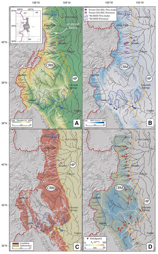
(A) Topographic map of the Colorado Rocky Mountains (1 arc-second Shuttle Radar Topography Mission). (Inset) Regional map of the
study area (gray polygon). WY—Wyoming; NE—Nebraska; CO—Colorado; NM—New Mexico. (B) Map of 30 yr normals for mean annual precipitation map (MAP; modified from Fick and Hijmans, 2017). OSL/IRSL—optically/infrared stimulated luminescence; BAER—basin-
averaged erosion rates. (C) Extent of the crystalline basement and sedimentary units (modified from Hartmann and Moosdorf, 2012). (D) Interpolated normalized channel steepness (ksn) map. CRM—Colorado Rocky Mountains; HP—High Plains. White lines mark analyzed basins. For
detailed basin averaged erosion rates (BAER), terrace luminescence ages, and river profile analysis, see the Supplemental Material (text footnote 4).
Geomorphic Predictions for Tectonic and Climate Hypotheses for Topographic Rejuvenation in the CRM
By integrating basin-averaged erosion rates, channel incision rates, and river profile patterns, we evaluate our findings against predictions from end-member tectonic and climate hypotheses concerning recent landscape rejuvenation in the CRM. This assessment considered the erodibility and lithologic contrasts between the High Plains and the CRM (Figs. 1 and 2; see Fig. S1 in Supplemental Material4; cf. Marder et al., 2023). The prevailing geodynamic hypothesis (Fig. 2; Leonard, 2002; McMillan and Heller, 2006) predicts higher erosion and incision rates, as well as increased channel steepness, in steeper reaches below convex-upward knickpoints in river profiles relative to more moderate reaches above them (Fig. 2; Fig. S1; Marder et al., 2023). Conversely, the prevailing climate hypothesis posits regionally uniform erosional efficiency reflecting modern elevation and precipitation gradients (Fig. 1B; Wobus et al., 2010; Duller et al., 2012), predicting higher erosion and incision rates, as well as increased channel steepnessin steeper reaches above convex-downward knickpoints relative to more moderate reaches below them (Fig. 2; Fig. S1).
Figure 2
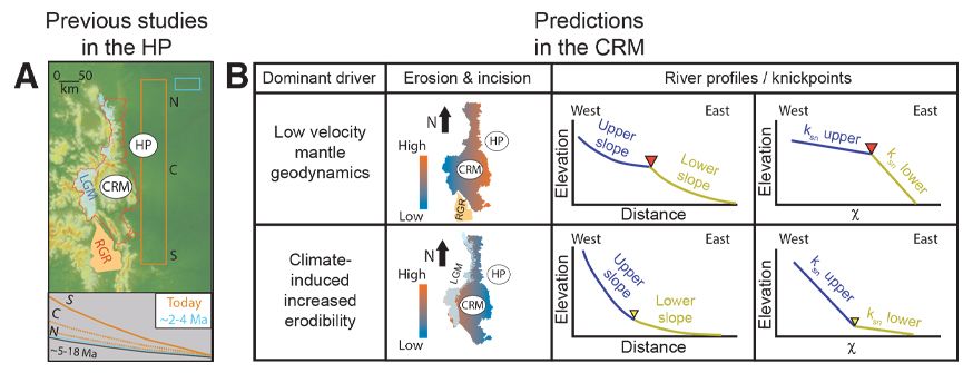
(A) (Top) Previous geomorphologic study extents and hypotheses for rapid incision and topographic rejuvenation in the High Plains (HP). Orange box—study by McMillan and Heller (2006) suggesting Pliocene rapid incision due to a geodynamic driver associated with the Rio Grande rift (RGR). Cyan box—study by Duller et al. (2012) suggesting rapid incision due to global climate changes in the last 2–4 m.y. Last Glacial Maximum extent (LGM; modified after Madole et al., 1998) is shown for reference. CRM—Colorado Rocky Mountains; HP—High Plains. (Bottom) Reconstructed river profiles in the High Plains from the same studies (colors correspond to top panel) and the gradient of the Ogallala Group surface at ca. 18–5 Ma (black line). N—north; C—central; S—south. (B) Predicted geomorphic patterns for tectonic and climate hypotheses for CRM rejuvenation in the last ~2–5 m.y. Geodynamic scenario: Increased landscape erosion, channel incision, and normalized channel steepness, ksn, in the lower CRM below slope-break convex-upward knickpoints (red inverted triangles). Climate scenario: Increased landscape erosion, channel incision, and channel steepness in the higher CRM above slope-break convex-downward knickpoints (yellow inverted triangles). χ—upstream integral of the inverse of drainage area raised to an exponent. For one-dimensional river profile simulations under these tectonic and climate scenarios, see Figure S1.
Methods
Basin-Averaged Erosion Rates and Channel Incision Rates
We used 10Be terrestrial cosmogenic nuclides to measure landscape erosion rates on ~103–106 yr time scales (Granger et al., 1996) and channel incision rates to assess geologically recent relief production or decay (Pazzaglia, 2013). We quantified basin-averaged erosion rates by measuring 10Be concentrations in quartz-rich fluvial sands at drainage basin outlets in the CRM using altitude- and latitude-dependent production rates and near-surface attenuation rates for different production pathways (Fig. 1; see the Supplemental Materials; Granger et al., 1996; cf. Dethier et al., 2014; Marder et al., 2023). To determine channel incision rates, we calculated incision depths below fluvial terrace straths to modern channels in the CRM and High Plains and divided them by terrace depositional ages derived from optical and infrared stimulated luminescence of quartz (OSL) and feldspar (IRSL) grains (Fig. 1; Schildgen et al., 2002; Mahan et al., 2022; see the Supplemental Materials).
River Profile Analysis of Bedrock Rivers
We used a 90-m-resolution digital elevation model (DEM) from the Shuttle Radar Topography Mission (SRTM) to analyze river profiles in the CRM, focusing on bedrock rivers, which are sensitive indicators of tectonic- and climate-induced base-level changes (Fig. 2; Fig. S1; Kirby and Whipple, 2012). We identified fluvial knickpoints, i.e., sharp changes in channel steepness along river longitudinal profiles caused by base-level fall changes at river outlets. These knickpoints were detected through changes in the normalized channel steepness index, ksn, a metric that allow comparisons of channel steepness between basins with different drainage areas (Kirby and Whipple, 2012). We calculated ksn for reaches above and below knickpoints using linear regression of a transformed coordinate, χ (the upstream integral of the inverse of drainage area raised to an exponent), against elevation, z (Fig. 2; see the Supplemental Materials; Kirby and Whipple, 2012; Perron and Royden, 2013; Marder et al., 2023):
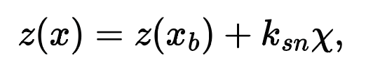
where z(xb) is the elevation at the river outlet (xb is a reference distance at base level, and x is river distance).
We analyzed nonglaciated trunk channels from 24 basins that incise into a similar crystalline basement and drain the CRM to its mountain front, where xb and z(xb)were set to zero (Fig. 1). Using a regional reference channel concavity index (which is consistent whether or not glaciated reaches are included; Fig. S2; see the Supplemental Materials), we calculated χ and used χ-z plots to identify fluvial knickpoints as inflection points with at least a 25% change in ksn to minimize noise and DEM artifacts in our analysis (Fig. S3; see the Supplemental Materials). We confirmed that knickpoints are transient migrating features from the CRM mountain front—rather than locally formed by lithologic changes or faults—by applying a basin-wide inversion model that examined the network-wide change in ksn as a function of χ (Eq. 1; Fig. S3; Gallen, 2018; Marder et al., 2023; see the Supplemental Materials).
Figure 3
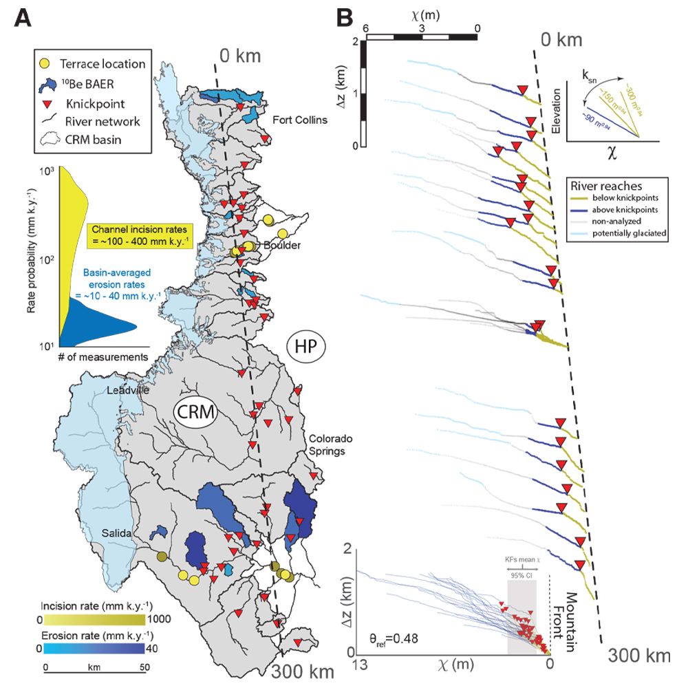
(A) Locations of knickpoints, basin-averaged erosion rate (BAER), and fluvial terraces across the Colorado Rocky Mountains (CRM) drainage network (shaded gray polygon) and High Plains (HP; nonshaded). Last Glacial Maximum extent (cyan polygon) is shown for reference. (Left inset) Kernel density estimator of BAER (blue) and channel incision rates (yellow). (B) River profiles of main trunks in the analyzed basins, projected north-to-south across the CRM (dashed line in A). Glaciated reaches are shown in cyan, and nonglaciated reaches above and below knickpoints are shown in blue and yellow, respectively. Note that χ transformation distorts river profiles by elongating low-drainage areas in χ plots (where χ is the upstream integral of the inverse of drainage area raised to an exponent). This distortion causes the low-drainage, glaciated portions of river profiles to appear more extensive than they actually are (cf. Fig. 3A). Scale bars show relative elevation (Δz) and χ for reference. (Upper-right inset) Channel steepness, ksn, in χ-elevation space. (Lower-left inset) Stacked χ-plots of river profiles vs. relative elevation from the CRM mountain front (black dashed line). Gray shaded polygon shows mean χ and its confidence intervals (CI) for all knickpoints (KPs). Reference concavity index, θref, used to calculate the river profiles, is noted. For full river profile analysis, see the Supplemental Material and Figure S3.
Landscape Erosion Rates, Channel Incision Rates, and River Morphologies in the CRM Drainage Network
Based on 12 new and six previously measured 10Be basin-averaged erosion rates (see the Supplemental Materials; Tables S1 and S2; Dethier et al., 2014), and seven new and 16 previously calculated channel incision rates (see the Supplemental Materials; Tables S3–S6; Schildgen et al., 2002), we find that (1) erosion rates are ~10–20 mm k.y.–1 in the northern and central CRM, and slightly higher at ~30–40 mm k.y.–1 in the southern CRM (Fig. 3A; Dethier et al., 2014); and (2) average channel incision rates in the CRM and High Plains below fluvial knickpoints are an order of magnitude higher than erosion rates, ranging from ~100 to 800 mm k.y.–1 (Fig. 3A; Schildgen et al., 2002). Channel incision rates are notably higher for shorter integrated time scales <60 k.y., potentially due to a “Sadler effect” time-scale bias or an incomplete averaging of terrace strath formation and abandonment (Finnegan et al., 2014; Gallen et al., 2015). However, incision rates for terraces older than 60 k.y. do not show significant changes with age, ranging from ~100 to 400 mm k.y.–1 (Fig. S4). This suggests that any potential temporal bias is minimized over longer time periods.
All 24 analyzed basin trunk channels in the CRM show convex-upward knickpoints that separate steeper reaches below the knickpoints from lower-gradient reaches above them upstream (Fig. 3B; see the Supplemental Material; Fig. S1; cf. Marder et al., 2023). The moderate reaches above the knickpoints show a roughly uniform lower ksn of ~80–90 m0.94, while ksn in the steeper reaches below the knickpoints gradually increases from ~150 m0.94 to 300 m0.94 from north to south (Figs. 3 and 4). The knickpoints have a mean χ value of ~2.5 m (±1σ = 1.07 m) and a relative elevation of ~100–800 m from the CRM mountain front (Fig. 3B). Within individual basins, knickpoints coincide with the same χ value in modeled ksn spikes from the basin-wide inverse model, supporting the interpretation that the knickpoints are actively migrating upstream from the CRM mountain front or farther downstream (Fig. 3B; Fig. S3).
Figure 4
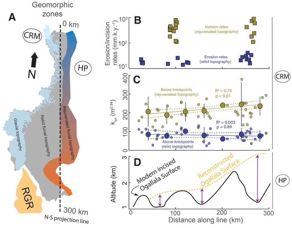
(A) Inferred geomorphic zones in the Colorado Rocky Mountains (CRM): (1) Rejuvenated, steeper fluvial topography (cool to warm gradient) between the CRM mountain front and 100–800 m above; (2) older, moderate fluvial topography (gray) bounded by the younger fluvial topography below and glacial topography above (light blue). Approximate location of the northern tip of the Rio Grande Rift (RGR) is marked (orange polygon). Dashed black line indicates projection line for B–C. HP—High Plains. (B) Basin-averaged erosion rates and channel incision rates projected north to south (line in A). (C) Raw and 25 km binned ksn values (represented by small and large filled circles, respectively) for river reaches upstream (blue) and downstream (yellow) of knickpoints, projected from north to south (line in A). Vertical error bars on the binned data indicate the 95% confidence interval. Linear regression models (dashed lines) were applied to the binned data (see Fig. S5 for a detailed bin analysis [text footnote 4]), with the corresponding R2 and p-value statistics noted. (D) Total incision depth of the Ogallala Group surface in the High Plains to modern rivers from north to south (after Leonard, 2002).
What Drives Landscape Rejuvenation in the CRM?
The observation that channel incision rates are an order of magnitude higher than basin-averaged erosion rates is consistent with local magnitudes and patterns reported in previous studies (Schildgen et al., 2002; Dethier et al., 2014). However, our findings reveal that this pattern is regionally persistent (Fig. 4). The discrepancy between erosion rates above knickpoints and channel incision rates below knickpoints suggests a geologically recent relief production of ~100 mm k.y.–1 since the migration of the knickpoints from the CRM mountain front to their current positions (Fig. 3). Notably, channel incision rates from the High Plains are comparable to those below knickpoints in the CRM, indicating that the increased base-level fall rate persists to the present (Fig. 3). The pronounced contrast in ksn along reaches above and below knickpoints corresponds to the disparity in erosion and incision rates, with ksn being low and uniform across the CRM region above knickpoints and systematically higher below knickpoints (Fig. 4C; Fig. S5).
Overall, the higher channel incision rates relative to landscape erosion rates and consistently higher ksn below knickpoints suggest a sustained increase in base-level fall rate over time. These geomorphic patterns are challenging to reconcile with climatic drivers, which would predict opposite geomorphologic trends (Fig. 2; Fig. S1). Instead, our results align with predictions of a geologically recent increase in rock uplift rate driven by regional geodynamics (Fig. 2; Fig. S1). Furthermore, we observed a north-to-south increase in ksn in channel reaches below knickpoints (Fig. 4C; Fig. S5), mirroring the southward increase in incision depth below a reconstructed Ogallala Group surface in the High Plains (Fig. 4D; Leonard, 2002) and a similar north-to-south trend in ksn on the western slopes of the CRM above a low seismic velocity zone (Rosenberg et al., 2014).
Thus, our study, along with previous geomorphic, geophysical, and thermochronometric research in the High Plains and the western CRM (Leonard, 2002; McMillan and Heller, 2006; MacCarthy et al., 2014; Rosenberg et al., 2014; Abbey and Niemi, 2018), supports the notion of regional landscape rejuvenation in the CRM. This rejuvenation appears to be driven by the far-field effects of regional geodynamic processes (e.g., Rio Grande rift, subduction of the Farallon-Kula plate; Leonard, 2002; Moucha et al., 2008; Abbott et al., 2022), manifesting as doming uplift centered in the southern CRM and near the northern tip of the Rio Grande rift. While climate remains an important factor in the region’s landscape evolution (Wobus et al., 2010; Duller et al., 2012), our study suggests that any climatic signals are likely superimposed on regional geomorphic patterns, which align more closely with a geodynamic driver.
More broadly, our results highlight that analyzing bedrock river profiles and associated data within a tectonic geomorphology framework can elucidate the drivers of transient landscape dynamics in postorogenic mountain belts. In the CRM, this approach points to geodynamics as the primary driver of recent landscape change, though different conclusions may be reached in other postorogenic mountain belts that have not experienced recent tectonic activity. Such studies could significantly enhance our understanding of the relative impacts of tectonics and climate in shaping Earth’s surface.
Acknowledgments
E. Marder appreciates the financial support provided by the Geological Society of America (GSA) AGeS2–National Science Foundation (NSF) grant EAR-1759200, the GSA Graduate Student Research Grant Program–NSF grant EAR-2323037, and the Colorado State University Department of Geosciences and Warner College of Natural Resources. S.F. Gallen acknowledges partial support from NSF grant EAR-2041910. We extend our gratitude to Peter Copeland, Eric Kirby, an anonymous reviewer, and Eric Leonard for their valuable comments, which significantly improved the manuscript.
References
- Abbey, A.L., and Niemi, N.A., 2018, Low-temperature thermochronometric constraints on fault initiation and growth in the northern Rio Grande rift, upper Arkansas River valley, Colorado, USA: Geology, v. 46, p. 627–630, https://doi.org/10.1130/G40232.1.
- Abbey, A.L., Niemi, N.A., Geissman, J.W., Winkelstern, I.Z., and Heizler, M., 2017, Early Cenozoic exhumation and paleotopography in the Arkansas River valley, southern Rocky Mountains, Colorado: Lithosphere, v. 10, p. 239–266, https://doi.org/10.1130/L673.1.
- Abbott, L.D., Flowers, R.M., Metcalf, J., Falkowski, S., and Niazy, F., 2022, Post-Laramide, Eocene epeirogeny in central Colorado—The result of a mantle drip?: Geosphere, v. 18, p. 1223–1246, https://doi.org/10.1130/GES02434.1.
- Aslan, A., Karlstrom, K.E., Kirby, E., Heizler, M.T., Granger, D.E., Feathers, J.K., Hanson, P.R., and Mahan, S.A., 2019, Resolving time-space histories of late Cenozoic bedrock incision along the Upper Colorado River, USA: Geomorphology, v. 347, https://doi.org/10.1016/j.geomorph.2019.106855.
- Chapin, C.E., and Kelley, S.A., 1997, The Rocky Mountain erosion surface in the Front Range of Colorado, in Bolyard, D.W., and Sonnenberg, S.A., eds., Geologic History of the Colorado Front Range: Colorado Front Range Guidebook 1997: Denver, Colorado, Rocky Mountain Association of Geologists, p. 101–114.
- Davis, W.M., 1911, The Colorado Front Range: A study in physiographic presentation: Annals of the Association of American Geographers, v. 1, p. 21–83, https://doi.org/10.2307/2560844.
- Dethier, D.P., Ouimet, W., Bierman, P.R., Rood, D.H., and Balco, G., 2014, Basins and bedrock: Spatial variation in 10Be erosion rates and increasing relief in the southern Rocky Mountains, USA: Geology, v. 42, p. 167–170, https://doi.org/10.1130/G34922.1.
- Dickinson, W.R., and Snyder, W.S., 1978, Plate tectonics of the Laramide orogeny, in Matthews, V., III, ed., Laramide Folding Associated with Basement Block Faulting in the Western United States: Geological Society of America Memoir 151, p. 355–366, https://doi.org/10.1130/MEM151-p355.
- Duller, R.A., Whittaker, A.C., Swinehart, J.B., Armitage, J.J., Sinclair, H.D., Bair, A., and Allen, P.A., 2012, Abrupt landscape change post– 6 Ma on the central Great Plains, USA: Geology, v. 40, p. 871–874, https://doi.org/10.1130/G32919.1.
- Eaton, G.P., 2008, Epeirogeny in the Southern Rocky Mountains region: Evidence and origin: Geosphere, v. 4, p. 764–784, https://doi.org/10.1130/GES00149.1.
- Fick, S.E., and Hijmans, R.J., 2017, WorldClim 2: New 1-km spatial resolution climate surfaces for global land areas: International Journal of Climatology, v. 37, p. 4302–4315, https://doi.org/10.1002/joc.5086.
- Finnegan, N.J., Schumer, R., and Finnegan, S., 2014, A signature of transience in bedrock river incision rates over timescales of 104–107 years: Nature, v. 505, p. 391–394, https://doi.org/10.1038/nature12913.
- Gallen, S.F., 2018, Lithologic controls on landscape dynamics and aquatic species evolution in post-orogenic mountains: Earth and Planetary Science Letters, v. 493, p. 150–160, https://doi.org/10.1016/j.epsl.2018.04.029.
- Gallen, S.F., Wegmann, K.W., and Bohnenstiehl, D.W.R., 2013, Miocene rejuvenation of topographic relief in the southern Appalachians: GSA Today, v. 23, p. 4–10, https://doi.org/10.1130/GSATG163A.1.
- Gallen, S.F., Pazzaglia, F.J., Wegmann, K.W., Pederson, J.L., and Gardner, T.W., 2015, The dynamic reference frame of rivers and apparent transience in incision rates: Geology, v. 43, p. 623–626, https://doi.org/10.1130/G36692.1.
- Granger, D.E., Kirchner, J.W., and Finkel, R., 1996, Spatially averaged long-term erosion rates measured from in situ–produced cosmogenic nuclides in alluvial sediment: The Journal of Geology, v. 104, p. 249–257, https://doi.org/10.1086/629823.
- Hartmann, J., and Moosdorf, N., 2012, The new global lithological map database GLiM: A representation of rock properties at the Earth surface: Geochemistry, Geophysics, Geosystems, v. 13, Q12004, https://doi.org/10.1029/2012GC004370.
- Hilton, R.G., and West, A.J., 2020, Mountains, erosion and the carbon cycle: Nature Reviews Earth & Environment, v. 1, p. 284–299, https://doi.org/10.1038/s43017-020-0058-6.
- Kirby, E., and Whipple, K.X., 2012, Expression of active tectonics in erosional landscapes: Journal of Structural Geology, v. 44, p. 54–75, https://doi.org/10.1016/j.jsg.2012.07.009.
- Lazear, G., Karlstrom, K., Aslan, A., and Kelley, S., 2013, Denudation and flexural isostatic response of the Colorado Plateau and southern Rocky Mountains region since 10 Ma: Geosphere, v. 9, p. 792–814, https://doi.org/10.1130/GES00836.1.
- Leonard, E.M., 2002, Geomorphic and tectonic forcing of late Cenozoic warping of the Colorado piedmont: Geology, v. 30, p. 595–598, https://doi.org/10.1130/0091-7613(2002)030<0595:GATFOL>2.0.CO;2.
- MacCarthy, J.K., Aster, R.C., Dueker, K., Hansen, S., Schmandt, B., and Karlstrom, K., 2014, Seismic tomography of the Colorado Rocky Mountains upper mantle from CREST: Lithosphere-asthenosphere interactions and mantle support of topography: Earth and Planetary Science Letters, v. 402, p. 107–119, https://doi.org/10.1016/j.epsl.2014.03.063.
- Madole, R.F., Van Sistine, D.P., and Michael, J.A., 1998, Pleistocene Glaciation in the Upper Platte River Drainage Basin, Colorado: U.S. Geological Survey Miscellaneous Investigations Series Map 2644, scale 1:500,000, https://doi.org/10.3133/i2644.
- Mahan, S.A., et al., 2022, Guide for interpreting and reporting luminescence dating results: Geological Society of America Bulletin, v. 135, no. 5–6, p. 1480–1502, https://doi.org/10.1130/B36404.1.
- Marder, E., Gallen, S.F., and Pazzaglia, F.J., 2023, Late Cenozoic deformation in the U.S. southern Colorado Front Range revealed by river profile analysis and fluvial terraces: Geological Society of America Bulletin, v. 136, no. 3–4, p. 1067–1085, https://doi.org/10.1130/B36440.1.
- McMillan, M.E., and Heller, P.L., 2006, History and causes of post-Laramide relief in the Rocky Mountain orogenic plateau: Geological Society of America Bulletin, v. 118, p. 393–405, https://doi.org/10.1130/B25712.1.
- McMillan, M.E., Angevine, C.L., and Heller, P.L., 2002, Postdepositional tilt of the Miocene–Pliocene Ogallala Group on the western Great Plains: Evidence of late Cenozoic uplift of the Rocky Mountains: Geology, v. 30, p. 64–66, https://doi.org/10.1130/0091-7613(2002)030<0063:PTOTMP>2.0.CO;2.
- Mitrovica, J.X., Beaumont, C., and Jarvis, G.T., 1989, Tilting of continental interiors by the dynamical effects of subduction: Tectonics, v. 8, p. 1079–1094, https://doi.org/10.1029/TC008i005p01079.
- Moucha, R., Forte, A.M., Rowley, D.B., Mitrovica, J.X., Simmons, N.A., and Grand, S.P., 2008, Mantle convection and the recent evolution of the Colorado Plateau and the Rio Grande rift valley: Geology, v. 36, p. 439–442, https://doi.org/10.1130/G24577A.1.
- Pazzaglia, F.J., 2013, 9.22 Fluvial terraces, in Shroder, J.F., ed., Treatise on Geomorphology, Volume 9: Fluvial Geomorphology: Amsterdam, Netherlands, Elsevier, p. 379–412, https://doi.org/10.1016/B978-0-12-374739-6.00248-7.
- Pelletier, J., 2009, The impact of snowmelt on the late Cenozoic landscape of the southern Rocky Mountains, USA: GSA Today, v. 19, no. 7, p. 4–10, https://doi.org/10.1130/GSATG44A.1.
- Perron, J.T., and Royden, L., 2013, An integral approach to bedrock river profile analysis: Earth Surface Processes and Landforms, v. 38, p. 570–576, https://doi.org/10.1002/esp.3302.
- Ricketts, J.W., Kelley, S.A., Karlstrom, K.E., Schmandt, B., Donahue, M.S., and van Wijk, J., 2016, Synchronous opening of the Rio Grande rift along its entire length at 25–10 Ma supported by apatite (U-Th)/He and fission-track thermochronology, and evaluation of possible driving mechanisms: Geological Society of America Bulletin, v. 128, p. 397–424, https://doi.org/10.1130/B31223.1.
- Riihimaki, C.A., Anderson, R.S., Safran, E.B., Dethier, D.P., Finkel, R.C., and Bierman, P.R., 2006, Longevity and progressive abandonment of the Rocky Flats surface, Front Range, Colorado: Geomorphology, v. 78, p. 265–278, https://doi.org/10.1016/j.geomorph.2006.01.035.
- Rosenberg, R., Kirby, E., Aslan, A., Karlstrom, K., Heizler, M., and Ouimet, W., 2014, Late Miocene erosion and evolution of topography along the western slope of the Colorado Rockies: Geosphere, v. 10, p. 641–663, https://doi.org/10.1130/GES00989.1.
- Schildgen, T., Dethier, D.P., Bierman, P., and Caffee, M., 2002, 26Al and 10Be dating of late Pleistocene and Holocene fill terraces: A record of fluvial deposition and incision, Colorado Front Range: Earth Surface Processes and Landforms, v. 27, p. 773–787, https://doi.org/10.1002/esp.352.
- Tucker, G.E., and van der Beek, P., 2013, A model for post-orogenic development of a mountain range and its foreland: Basin Research, v. 25, p. 241–259, https://doi.org/10.1111/j.1365-2117.2012.00559.x.
- Willett, S.D., and Brandon, M.T., 2002, On steady states in mountain belts: Geology, v. 30, p. 175, https://doi.org/10.1130/0091-7613(2002)030<0175:OSSIMB>2.0.CO;2.
- Willett, S.D., McCoy, S.W., and Beeson, H.W., 2018, Transience of the North American High Plains landscape and its impact on surface water: Nature, v. 561, p. 528–532, https://doi.org/10.1038/s41586-018-0532-1.
- Wobus, C.W., Tucker, G.E., and Anderson, R.S., 2010, Does climate change create distinctive patterns of landscape incision?: Journal of Geophysical Research, v. 115, F04008, https://doi.org/10.1029/2009JF001562.
