
Forecast, Monitor, Adapt: A Multi-Agency Effort to Protect People during Postfire Debris Flows
Francis Rengers et al.
In this article
Authors
Francis Rengers
U.S. Geological Survey, Geologic Hazards Science Center, Golden, Colorado 80401, USA
Jason Kean
U.S. Geological Survey, Geologic Hazards Science Center, Golden, Colorado 80401, USA
Cory Williams
U.S. Geological Survey, Colorado Water Science Center, Grand Junction, Colorado 81505, USA
Mark Henneberg
U.S. Geological Survey, Colorado Water Science Center, Grand Junction, Colorado 81505, USA
J. Banta
U.S. Geological Survey, California Water Science Center, Sacramento, California 95819, USA
Eric Schroder
U.S. Forest Service, BAER Program, Lakewood, Colorado 80401, USA
Cara Sponaugle
U.S. Forest Service, National Post-Fire Program, Washington, D.C. 20250, USA
David Callery
U.S. Forest Service, National Post-Fire Program, Washington, D.C. 20250, USA
Erin Walter
Grand Junction Weather Forecast Office, National Weather Service, Grand Junction, Colorado 81506, USA
Todd Blake
Maintenance Operations, Colorado Department of Transportation, Grand Junction, Colorado 81505, USA
Dennis Staley
U.S. Geological Survey, Alaska Volcano Observatory, Anchorage, Alaska 99508, USA
Abstract
In 2020, a wildfire burned across Glenwood Canyon in Colorado, USA. A history of postfire debris flows in the region and a hazard assessment for the burn area indicated that potentially life-threatening debris flows could be triggered by rainfall within months of a wildfire. As a result, four government agencies evaluated strategies to help mitigate hazards, including the loss of human life, that may be associated with debris-flow events. After the fire, 26 large debris flows occurred in the summer of 2021 and three sediment-laden flows occurred in the summer of 2023, but there were no major injuries or fatalities reported. We found that integrating hazard assessment/forecasting, monitoring, and adaptation scenarios was a successful strategy for reducing postfire debris-flow risks to human life (including injuries and fatalities). Weather forecasts and estimates of debris-flow-triggering rainfall thresholds, likelihood, and volume were used to anticipate the timing, location, and magnitude of debris-flow events. Rainfall monitoring and detailed recordkeeping of storms that triggered debris flows were used to validate and update debris-flow warning thresholds that varied with time following the wildfire. Although the governmental agencies working in this burn area had distinct and differing agency mandates, they were able to integrate information to reduce the risk of debris-flow events to human life.
*frengers@usgs.gov
CITATION: Rengers, F.K., et al., 2025, Forecast, monitor, adapt: A multi-agency effort to protect people during postfire debris flows: GSA Today, v. 35, no. 8, p. 16–21, https://doi.org/10.1130/GSATG611A.1.
© 2025 The Author. Gold Open Access: This paper is published under the terms of the CC-BY-NC license. Printed in USA.
Introduction
Wildfires create a variety of secondary natural hazards including rockfall, debris flows, and flooding (e.g., McGuire et al., 2024). These natural hazards can cross-cut boundaries of landownership and infrastructure type. Consequently, effective planning to enhance public safety from postfire natural hazards can benefit from collaboration across government agencies that manage land and assets the natural hazards might intersect. Because government management agencies are composed of specialists with specific mandates ranging from forest management to highway transportation, working across those specialties is critical for managing large-scale natural hazards.
In the fall of 2020, state and federal government agencies in Colorado, USA, were confronted with the challenge of preparing response scenarios for postfire hazards following the Grizzly Creek Fire. The Grizzly Creek Fire burned 13,000 ha across Glenwood Canyon in Colorado, a steep gorge that also hosts a variety of critical infrastructure. Interstate 70 (I-70), which serves as a major transportation corridor moving up to $1 million/hour (Erku, 2023); the Union Pacific Railroad; and the Colorado River, an important source of drinking water, energy generation, and recreation are located at the bottom of Glenwood Canyon (Rengers et al., 2024; Fig. 1). The burn area included large swaths of the White River National Forest managed by the U.S. Forest Service (USFS), Bureau of Land Management parcels, private land, and corridors managed by the Colorado Department of Transportation (CDOT). The postfire natural hazard potential threatened many activities and assets such as road safety, water supply, water quality, fish habitat, and train operations. Here, we focus on government agency activities to help mitigate hazards to highway operations through the canyon from postfire debris flows.
There is a history of postfire debris flows in the region that caused concern following the Grizzly Creek Fire (Cannon et al., 2003, 2001). For example, following both the South Canyon Fire (1994) and the Coal Seam Fire (2002) near Glenwood Canyon, debris flows were recorded within two months of the wildfire and affected highway safety (Cannon et al., 2003, 2001). Consequently, following the Grizzly Creek Fire, the U.S. Geological Survey (USGS), USFS, CDOT, and National Weather Service (NWS) worked together to develop a set of potential scenarios based on the best available science to address and mitigate postfire hazards. During the fire, and following containment, these four government agencies contributed to developing ways to mitigate postfire hazards based on their respective organizational mandates: USGS (debris-flow hazard assessment and monitoring), NWS (meteorological forecasting and warning), CDOT (road safety logistics and observation), and USFS (soil burn severity, hydrologic analysis, and postfire emergency risk assessment on National Forest Service lands).
The USGS, NWS, CDOT, and USFS used a strategy of forecasting (prior to a storm), monitoring (during and after storms), and adapting (before and after storms) to mitigate postfire debris-flow hazards. Forecasting included estimating rainfall rates from weather models, as well as statistical modeling of debris-flow initiation and debris-flow volume based on the fire burn severity, terrain, and probable rainfall scenarios. Monitoring activities included measuring rainfall rates with a network of gauges installed across the burn area (Fig. 1A) and recording the location and timing of debris flows in the burn area based on cameras and surveys along I-70 by CDOT following each storm. Finally, adaptation included anticipating hazards prior to storms and preemptively closing I-70, as well as adapting debris-flow rainfall thresholds based on observations.
Figure 1
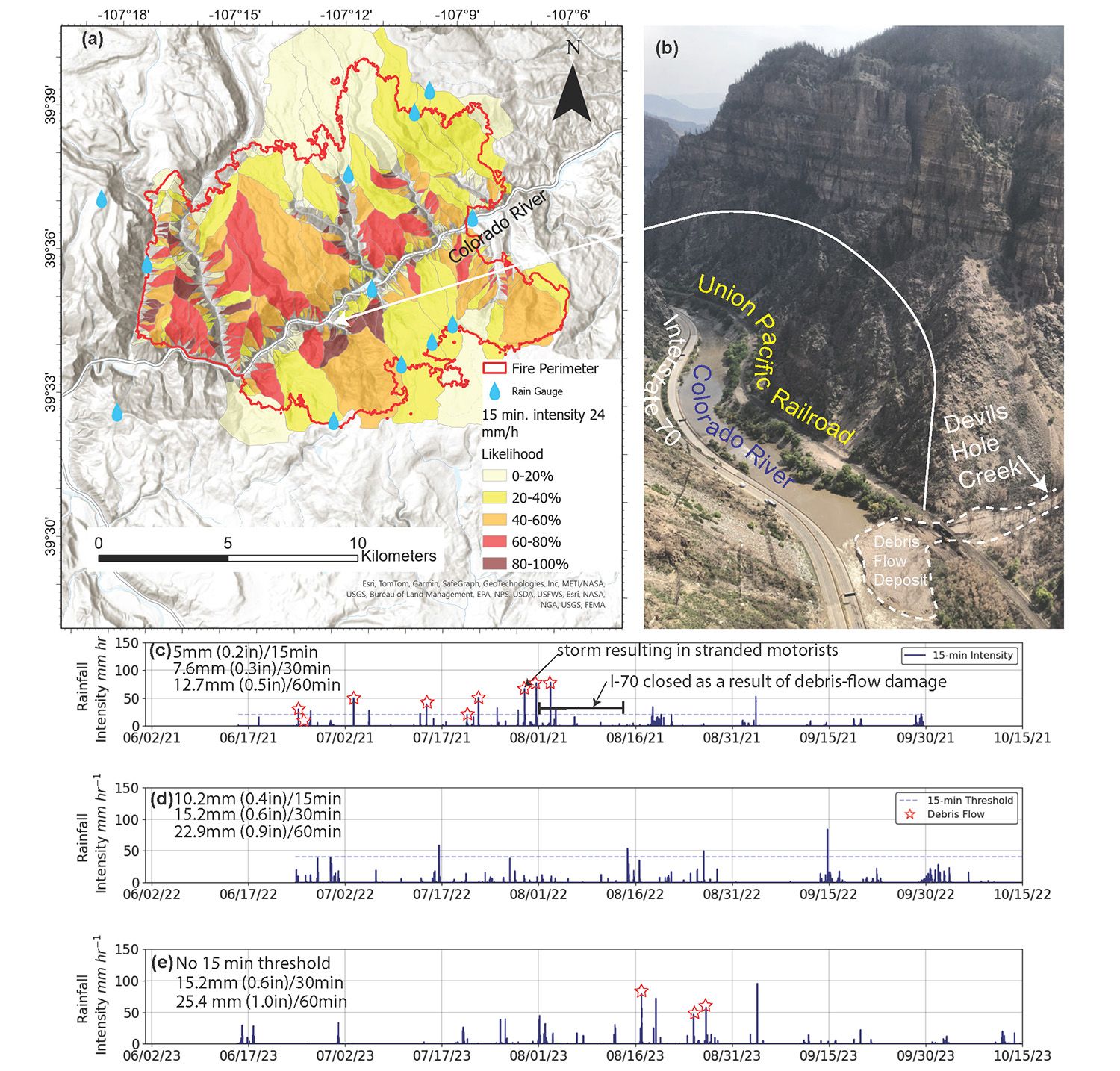
(A) Hazard assessment map showing the debris-flow likelihood in small watersheds assuming a rainfall rate of 24 mm/hr following the methods of Staley et al. (2017). (B) Photo of one of the 26 recorded debris flows during the summer of 2021 (Photo Credit: F. Rengers). This debris flow originated in the Devils Hole Creek watershed and deposited underneath a railroad trestle, narrowing the Colorado River width by more than two-thirds. (C) Maximum 15 min rainfall intensity (measured from 11 rain gauges) during the summer of 2021 (one year postfire). Stars indicate a debris-flow observation; the specific locations of debris flows are indicated in Rengers et al. (2024). (D) Maximum 15 min rainfall intensity (measured from 11 rain gauges) during the summer of 2022 (two years postfire). (E) Maximum 15 min rainfall intensity (measured from 11 rain gauges) during the summer of 2023 (three years postfire). Rainfall thresholds to issue hazard warnings, which are listed in the upper left corner of each yearly panel, were adjusted upwards each year based on observations of debris-flow activity. Units are listed in millimeters and inches over specified time durations.
After the Fire Before the Storms
Forecasting Hazards
The postfire forecasting response to the Grizzly Creek Fire began while the fire was still burning. The Grizzly Creek Fire started on 10 August 2020, burned within Glenwood Canyon until 24 August 2020, and was not fully contained until 18 December 2020. I-70 and the White River National Forest were closed for two weeks in August 2020 as the fire progressed (Stroud, 2021a). During this time, management agencies recognized that developing ways to reduce debris-flow hazard risks could help protect public safety along the I-70 corridor.
To forecast future debris flows and reduce risks associated with landslide threats to property, infrastructure, and life, the USGS developed a preliminary debris-flow hazard assessment on 14 August 2020 (after the fire started) using estimates of the potential burn severity (Staley et al., 2018). The hazard assessment was used to forecast debris-flow likelihood and volume, and to estimate the triggering rainfall thresholds for individual drainage basins and channel segments based on topography, soil burn severity, and soil erodibility (Staley et al., 2017). Because the hazard assessment identified areas that could be affected by debris flows, it provided an opportunity to develop plans to avoid those hazards.
An advance USFS Burned Area Emergency Response (BAER) team was also assigned to the area to forecast hazards and coordinate with partners, followed by a standard BAER team assessment after additional fire containment (U.S. Forest Service, 2020). BAER teams are mandated to assess postfire risk to resources and infrastructure and to recommend mitigation on USFS lands to minimize hazards associated with burned-area conditions. These assessments typically occur when fire containment is nearing completion, but concern over immediate threats to the numerous assets below White River National Forest lands prompted an advance team prior to the full assessment team. On 17 August 2020, this advance BAER team obtained satellite imagery to develop a preliminary soil burn severity map and released the validated map publicly on 18 August 2020 (U.S. Forest Service, 2020). This soil burn severity map was used by the USGS to generate a new postfire debris-flow assessment hazard map on 18 August 2020 based on field-verified data (Fig. 1; U.S. Geological Survey, 2020).
Following the advance BAER team assessment, several state and local emergency response agencies were invited to coordination meetings with stakeholders, including: the City of Glenwood Springs, CDOT, Emergency Service leaders from Garfield and Eagle Counties, NWS, USGS, Natural Resources Conservation Service (NRCS), Bureau of Land Management (BLM), Xcel Energy, and the Union Pacific Railroad. A standard BAER team was initiated on 8 September 2020 to assess the postfire risks to USFS lands, property, and resources in closer detail. A final soil burn severity map for the Grizzly Creek Fire was completed on 10 September 2020 (U.S. Forest Service, 2020) and soil erosion, hydrologic response, and debris-flow model input was updated by the USGS to generate final hazard assessment maps (U.S. Geological Survey, 2020). Consequently, these agencies forecasted hazards using multiple models, which were continuously refined as more information was obtained.
Figure 2
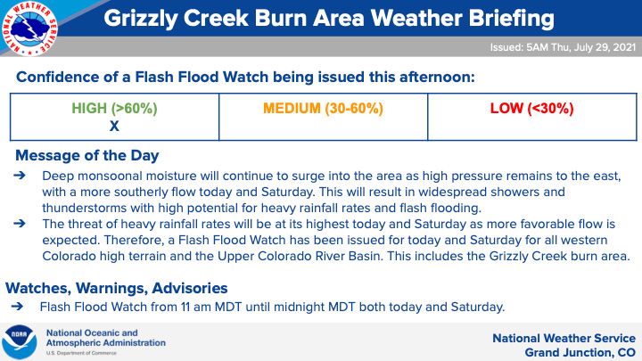
Example of an email message from the National Weather Service with forecasting information. The briefing demonstrated here was issued at 5 a.m. local time (MDT) on 29 July 2021.
Coordinated Interagency Response
No intense rainstorms affected the Grizzly Creek burn area in the late summer/autumn after the fire started. During the winter following wildfire containment, agencies coordinated to continue debris-flow forecasting in preparation for the following summer when the North American Monsoon (NAM; Adams and Comrie, 1997) typically results in thunderstorms. The USGS hazard assessment included an estimate of the fire-wide rainfall threshold for debris-flow initiation. This rainfall threshold was provided to the NWS. The estimated threshold for the Grizzly Creek burn area (6.5 mm in 15 min) was within the range of rainfall thresholds observed in the 2002 Coal Seam Fire (3.3mm–9.6mm in 10 min; Cannon et al., 2008). However, the NWS decided to adopt a slightly lower threshold (5 mm in 15 min) as a conservative starting point for warnings (Fig. 1C). Subsequently, the NWS forecasted rainfall intensities of incoming storms over the burn area using radar and weather models. This led to an operational strategy for road closure by CDOT. CDOT decided to station workers at both ends of Glenwood Canyon on I-70 to close the road if the NWS generated a flash flood watch, which is an official nomenclature that also includes debris flows (National Weather Service, 2025). The NWS would initiate the flash flood watch with 1 hr to 1 day lead time if a weather forecast had a greater than 50% chance of rainfall above the threshold. If the NWS elevated the watch to a warning (issued when a storm is imminent), CDOT staff would close the highway, which could drastically affect commute times along I-70. The decision to close the road had a high consequence, increasing a drive that normally takes 15–20 min to a detour that could take drivers up to 4 hr (Collins, 2021). The NWS additionally provided storm outlook messages for decision makers twice per week (Fig. 2).
As part of monitoring efforts, USGS landslide hazard scientists worked with the USFS to install three (non-telemetered) rain gauges in the White River National Forest to monitor incoming storms in September 2020. Seven additional (telemetered) rain gauges were installed in the summer of 2021 by USGS scientists working in partnership with local stakeholders. Five of the telemetered USGS rain gauges maintained cellular connections, providing near-instantaneous notification to NWS of rainfall events. Two additional telemetered rain gauges were installed by CDOT, although due to mechanical failure, only one of the CDOT rain gauges was usable. The network of telemetered rain gauges distributed across the burn area (Fig. 1A) provided near-real-time data on rainfall that complimented estimates of rainfall from weather radar. Finally, CDOT monitored I-70 for flow activity after each rainstorm using stationary cameras, roadway surveys, and aerial surveys, and cataloged whether a debris flow or a flood was observed.
The adaptation effort prior to the monsoon rain season focused on developing ways to mitigate hazards associated with debris flows. For example, during the fire, the USFS BAER team used the USGS debris-flow hazard assessment to help identify the potential infrastructure (such as roads and buildings) and ecosystems (such as forests, wetlands, and species) that could be at risk. Based on their assessment, the BAER team suggested building a berm near the CDOT command center (Fig. 3), which is only one of four in the state used to monitor road safety in the canyon and throughout a large quadrant of the state of Colorado. Additional effects to local waterways were anticipated from the debris flows, and instream monitoring of water quality was implemented by the USGS to mitigate potential effects to downstream water-supply infrastructure.
Figure 3
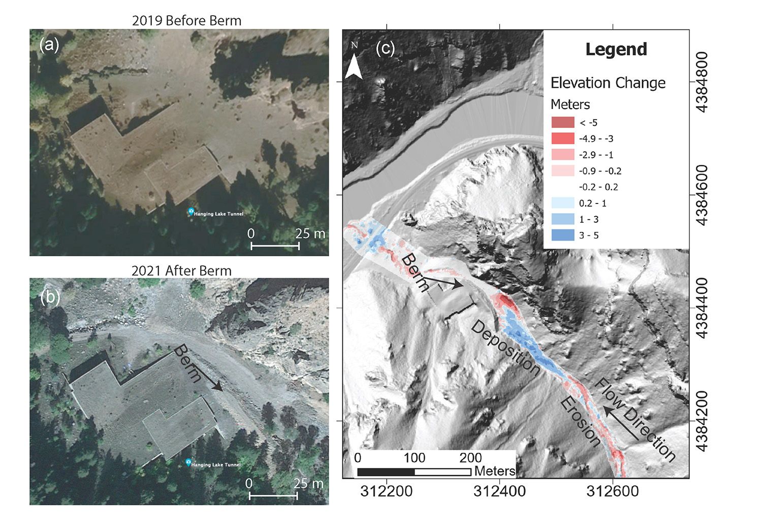
(A) Google Earth imagery (accessed 4 Dec. 2024) of the Colorado Department of Transportation (CDOT) command center prior to the fire. (B) Google Earth imagery of the CDOT command center after the construction of a berm recommended by the U.S. Forest Service Burned Area Emergency Response team. (C) Light detection and ranging (LiDAR) difference showing debris-flow deposition that was prevented from hitting the infrastructure because of the construction of the berm. Coordinates are in UTM Zone 13 N. LiDAR shaded relief developed from topography located in Rengers et al. (2023a).
2021 Monsoon Rains
Beginning on 26 June 2021, rainstorms associated with the seasonal monsoon began delivering high-intensity rain to the Grizzly Creek burn area. During the summer of 2021, there were 49 rainstorms and I-70 was closed 14 times (Rengers et al., 2024). Nine of the rainstorms produced debris flows, with the highest recorded rainfall event taking place on 31 July 2021. That rainstorm resulted in extensive damage to I-70 (which closed the highway for 2 weeks), and the estimated repair costs were $116 million (Otarola, 2021). During this time, water-quality conditions in the Colorado River were affected by high sediment concentrations that required enhanced treatment processes to prepare water for municipal consumption. During the post-storm adaptation phase, USGS scientists used an inventory of rainfall and debris-flow observations from the continuous monitoring (Rengers et al., 2023b) in order to guide adjustments to the warning strategies. For example, the inventory largely validated the year one 15 min rainfall threshold, and that data helped to justify increases in the thresholds in subsequent years as gradual recovery of vegetation reduced debris-flow hazards (Fig. 1C–E).
In this case study of the Grizzly Creek Fire, the effort to “forecast, monitor, and adapt” was effective to help mitigate potential debris-flow hazards. Despite nine major storms causing debris flows in 2021, there were no major reported debris-flow-related injuries or fatalities in Glenwood Canyon, likely because I-70 was frequently closed as a result of debris-flow hazard mapping, rainfall monitoring efforts, and the warning system developed by the USGS, NWS, CDOT, and USFS. An example of a near-miss scenario happened on the evening of 29 July 2021 (Fig. 1C). The highway (I-70) was closed late in the afternoon due to an NWS flash flood warning issued at 4:12 p.m. (local time), but the warning was canceled at 5:18 p.m. (local time) and the road reopened. Around 8:30 p.m. another round of heavy rains began (Fig. 1), which prompted a second flash flood warning for the day at 8:45 p.m. However, this rainstorm triggered multiple debris flows that inundated the road before it could be closed. By 9 p.m., motorists trapped in the canyon were escorted to safety in the Hanging Lake Tunnel, which is underground and adjacent to the CDOT command center (Fig. 3), where they remained for the entire night (Stroud, 2021b). One motorist’s vehicle was struck by the debris flow, and she narrowly escaped by abandoning her car and running down the highway to safety (Otarola, 2021). The command center was nearly hit by a debris flow, but damage was prevented by the protective berm that was constructed immediately after the Grizzly Creek wildfire based on recommendations by the USFS BAER team (Fig. 3).
Figure 4
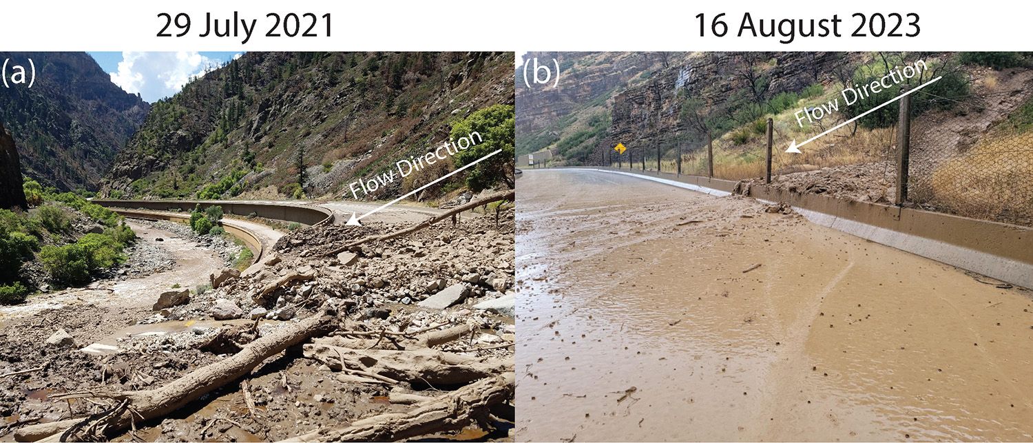
Differences in flow size from the first to third year after the wildfire. (A) A debris flow during the first postfire summer (2021) depositing material on both east-bound and west-bound highway lanes, as well as in the Colorado River. (B) A sediment-laden flow during the third year after the fire (2023) depositing material behind a concrete barrier with minor mud on the highway. (Photo credits: Colorado Department of Transportation).
Evolving Hazard with Time
Following the summer of 2021, the interagency team of the USGS, NWS, CDOT, and USFS continued to work together to mitigate debris-flow hazards. The team used annual inventories of storms and debris-flow activity to update rainfall thresholds. In the second year following wildfire, there were no observed debris flows. However, in the third year after the fire, three sediment-laden flows were observed (Fig. 4). The sediment for the sediment-laden flows in the third year appeared to be derived from remobilized sediment from drainages that previously produced debris flows. The effects of the third-year flows were minor compared to the first year (Fig. 4). Currently, there is guidance in the scientific literature on rainfall thresholds for the first year after the fire, but similar guidance for rainfall thresholds for the second and following years is not well known and dependent on local rates of vegetation recovery (Graber et al., 2023).
Concluding Remarks
When government agencies bring their individual expertise together, they can use science and engineering to formulate methods that may mitigate the effects of natural hazards and provide critical guidance to help inform public safety. The collaboration between multiple government agencies (USFS, USGS, NWS, and CDOT) following the Grizzly Creek Fire demonstrates how risks (including the potential for injury and loss of human life) from natural hazards can be mitigated when government agencies coordinate and leverage their interdisciplinary expertise. The government agencies involved in the Grizzly Creek postfire response (USFS, USGS, NWS, CDOT) integrated forecasting (hazard assessments and weather), monitoring (collecting data), and adaptation (anticipating hazards and adjusting warning criteria) to develop monitoring criteria to reduce the potential for loss of human life in a region with critical infrastructure that may be highly susceptible to debris-flow events following wildfires. This integration of agency data and interdisciplinary expertise may help inform future scenarios where debris-flow hazards can affect human life, critical infrastructure, and property.
Acknowledgments
This work was supported in part by the U.S. Geological Survey Landslide Hazards Program, Groundwater and Streamflow Information Program, and Next Generation Water Observing System Program. Additional support was provided by local stakeholders and agencies, including the Middle Colorado Watershed Council and the Colorado River District. Any use of trade, firm, or product names is for descriptive purposes only and does not imply endorsement by the U.S. Government.
References
- Adams, D.K., and Comrie, A.C., 1997, The North American monsoon: Bulletin of the American Meteorological Society, v. 78, p. 2197–2213, https://doi.org/10.1175/1520-0477(1997)078<2197:TNAM>2.0.CO;2.
- Cannon, S., Gartner, J.E., Holland-Sears, A., Thurston, B.M., and Gleason, J.A., 2003, Debris-flow response of basins burned by the 2002 Coal Seam and Missionary Ridge fires, Colorado: Association of Engineering Geologists Special Publication 14.
- Cannon, S., Gartner, J.E., Wilson, R.C., Bowers, J.C., and Laber, J.L., 2008, Storm rainfall conditions for floods and debris flows from recently burned areas in southwestern Colorado and southern California: Geomorphology, v. 96, p. 250–269, https://doi.org/10.1016/j.geomorph.2007.03.019.
- Cannon, S., Kirkham, R.M., and Parise, M., 2001, Wildfire-related debris-flow initiation processes, Storm King Mountain, Colorado: Geomorphology, v. 39, p. 171–188, https://doi.org/10.1016/S0169-555X(00)00108-2.
- Collins, V., 2021, Mudslide on scenic Colorado highway tests limits of aging infrastructure in era of climate change: https://www.nbcnews.com/news/us-news/mudslide-scenic-colorado-highway-tests-limits-aging-infrastructure-era-climate-n1278771 (accessed May 2025).
- Erku, R., 2023, Steady revegetation on Glenwood Canyon burn scar is a ray of sunshine for interstate commerce: https://www.postindependent.com/news/steady-revegetation-on-glenwood-canyon-burn-scar-a-ray-of-sunshine-for-interstate-commerce (accessed April 2023).
- Graber, A.P., Thomas, M.A., Kean, J.W., 2023, How long do runoff‐generated debris‐flow hazards persist after wildfire?: Geophysical Research Letters, v. 50, no. 19, https://doi.org/10.1029/2023GL105101.
- McGuire, L.A., Ebel, B.A., Rengers, F.K., Vieira, D.C., and Nyman, P., 2024, Fire effects on geomorphic processes: Nature Reviews Earth & Environment, v. 5, p. 486–503, https://doi.org/10.1038/s43017-024-00557-7.
- National Weather Service, 2025, National Weather Service Glossary: https://forecast.weather.gov/glossary.php (accessed May 2025).
- Otarola, M., 2021, “The whole car went black:” What it was like being trapped in the I-70 Glenwood Canyon mudslide: https://www.cpr.org/2021/08/03/i-70-glenwood-canyon-mudslide-trapped-tunnel (accessed December 2021).
- Rengers, F.K., Bethel, M., Group, R., Vessely, M., and Anderson, S., 2023a, Airborne Lidar Data (2016 and 2021) Capturing Debris Flow Erosion and Deposition after the Grizzly Creek Fire in Glenwood Canyon, Colorado: U.S. Geological Survey Data Release, https://doi.org/10.5066/P99OT77K.
- Rengers, F.K., Bower, S.J., Knapp, A., Kean, J.W., Staley, D.M., Banta, J.R., and Williams, C., 2023b, Debris Flow, Precipitation, and Volume Measurements in the Grizzly Creek Burn Perimeter June 2021–September 2022, Glenwood Canyon, Colorado (ver. 1.1, October 2023): U.S. Geological Survey Data Release, https://doi.org/10.5066/P9Z7RROL.
- Rengers, F.K., Bower, S., Knapp, A., Kean, J.W., vonLembke, D.W., Thomas, M.A., Kostelnik, J., Barnhart, K.R., Bethel, M., Gartner, J.E., Hille, M., Staley, D.M., Anderson, J.K., Roberts, E.K., DeLong, S.B., Lane, B., Ridgway, P., and Murphy, B., 2024, Evaluating post-wildfire debris-flow rainfall thresholds and volume models at the 2020 Grizzly Creek Fire in Glenwood Canyon, Colorado, USA: Natural Hazards and Earth System Sciences, v. 24, no. 6, https://doi.org/10.5194/nhess-24-2093-2024.
- Staley, D.M., Negri, J.A., Kean, J.W., Laber, J.L., Tillery, A.C., and Youberg, A.M., 2017, Prediction of spatially explicit rainfall intensity–duration thresholds for post-fire debris-flow generation in the western United States: Geomorphology, v. 278, p. 149–162, https://doi.org/10.1016/j.geomorph.2016.10.019.
- Staley, D.M., Tillery, A.C., Kean, J.W., McGuire, L.A., Pauling, H.E., Rengers, F.K., and Smith, J.B., 2018, Estimating post-fire debris-flow hazards prior to wildfire using a statistical analysis of historical distributions of fire severity from remote sensing data: International Journal of Wildland Fire, v. 27, no. 9, p. 595–608, https://doi.org/10.1071/WF17122.
- Stroud, J., 2021a, 2020’s story of the year—Grizzly Creek Fire forces evacuations, two-week closure of I-70 in Glenwood Canyon: https://www.postindependent.com/news/2020s-story-of-the-year-grizzly-creek-fire-forces-evacuations-two-week-closure-of-i-70-in-glenwood-canyon/ (accessed May 2025).
- Stroud, J., 2021b, Travelers stranded during second Glenwood Canyon closure Thursday night, hole up at tunnels until they could be escorted out safely: https://www.vaildaily.com/news/travelers-stranded-during-second-glenwood-canyon-closure-thursday-night-hole-up-at-tunnels-until-they-could-be-escorted-out-safely/ (accessed December 2022).
- U.S. Forest Service, 2020, Grizzly Creek Colorado 2020 Soil Burn Severity Map: https://edcintl.cr.usgs.gov/downloads/sciweb1/shared/MTBS_Fire/data/baer/grizzlycreek_sbs.zip (accessed May 2025).
- U.S. Geological Survey, 2020, Grizzly Creek (White River National Forest, CO) Post-Wildfire Debris Flow Hazard Assessment: https://landslides.usgs.gov/hazards/postfire_debrisflow/detail.php?objectid=295.
