
Deep Lithospheric Controls on Surface Deformation and Seismicity around the East Anatolian Fault Zone and A³ Triple Junction
Jonathan R. Delph et al.

In this article
Authors
Jonathan R. Delph*
Department of Earth, Atmospheric, and Planetary Sciences, Purdue University, West Lafayette, Indiana 47907, USA
Michael H. Darin
Oregon Department of Geology and Mineral Industries, Portland, Oregon 97232, USA
Donna L. Whitney
Department of Earth and Environmental Sciences, University of Minnesota, Minneapolis, Minnesota 55455, USA
Michael A. Cosca
U.S. Geological Survey, Denver Federal Center, Denver, Colorado 80225, USA
Christian Teyssier
Department of Earth and Environmental Sciences, University of Minnesota, Minneapolis, Minnesota 55455, USA
Nuretdin Kaymakcı
Department of Geological Engineering, Middle East Technical University, Cankaya, Ankara, Türkiye
Tuna Eken
Department of Geophysical Engineering, Faculty of Mines, Istanbul Technical University, Istanbul, Türkiye
Mary R. Reid
School of Earth and Sustainability, Northern Arizona University, Flagstaff, Arizona 86011, USA
Susan L. Beck
Department of Geosciences, University of Arizona, Tucson, Arizona 85721, USA
Abstract
The East Anatolian Fault Zone (EAFZ) is a plate-bounding strike-slip fault capable of hosting large earthquakes, as demonstrated by the extremely damaging February 2023 Mw 7.8 and Mw 7.7 mainshocks of the Kahramanmaraş earthquake sequence. Deformation related to this boundary, part of the Anatolia-Arabia-Africa (A3) Triple Junction, is diffuse, as was shown by part of this earthquake sequence occurring on a northern splay of the EAFZ (the Sürgü-Çardak Fault Zone; SCFZ). Controls on surface deformation are commonly linked to stress in the brittle upper crust, but the complex deformation and seismicity patterns in this region may also reflect deeper processes, such as variations in the location and extent of the strong Arabian Plate lithospheric mantle. Seismic tomography indicates that the Arabian Plate underthrusts Anatolia as far north as the SCFZ and extends as far west as the central Adana Basin, coincident with a zone of relatively deep (>30 km) strike-slip seismogenesis that has produced Mw >6 earthquakes. By investigating the relationship between deformation since the inception of the EAFZ (ca. 5 Ma), seismic structure, and seismicity, we infer that the SCFZ will become the future SE boundary of the Anatolian Plate as part of the evolving A3 Triple Junction.
*jdelph@purdue.edu
CITATION: Delph, J.R., et al., 2024, Deep lithospheric controls on surface deformation and seismicity around the East Anatolian Fault Zone and A3 Triple Junction: GSA Today, v. 34, p. 4–12, https://doi.org/10.1130/GSATG584A.1.
© 2024 The Authors. Gold Open Access: This paper is published under the terms of the CC-BY-NC license. Printed in USA.
Manuscript received 18 August 2023. Revised manuscript received 27 February 2024. Manuscript accepted 30 April 2024. Posted 25 June 2024.
Overview
The Anatolian Plate represents a classic “tectonic escape” system as it moves west away from the Arabia-Eurasia collision zone toward the Aegean extensional domain along the strike-slip faults of the North and East Anatolian Fault Zones (NAFZ, EAFZ; Şengör et al., 1985; Reilinger et al., 2006; Fig. 1). The plate-bounding NAFZ and EAFZ have hosted very large earthquakes (Mw >7) and represent the highest seismic hazards in Turkey (AFAD, 2018). In addition, these faults occur in areas of very high population density, making them likely candidates for seismic natural disasters.
Figure 1
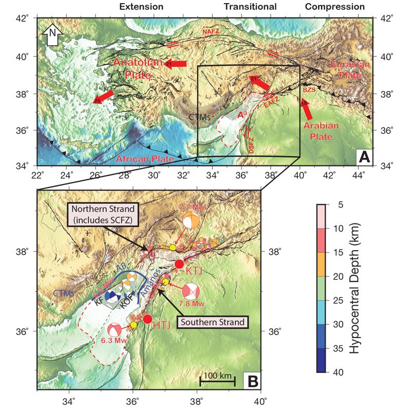
(A) Regional tectonic map of the Eastern Mediterranean showing the study area (black box) near the transition from Arabia-Anatolia collision to Africa-Anatolia subduction along the diffuse Anatolia-Arabia-Africa (A3) Triple Junction. Plate motions relative to Eurasia (Reilinger et al., 2006). NAFZ, EAFZ, and DSFZ: North Anatolian, East Anatolian, and Dead Sea Fault Zones; BZS: Bitlis-Zagros Suture; CTMs: Central Taurus Mountains (shaded area). (B) Study area showing epicenters of the 2023 earthquake sequence (Melgar et al., 2023) and deeper seismicity with focal mechanisms below the Adana Basin (AB; blue line; Ergin et al., 2004). Moment tensors for the 2023 earthquake sequence from the Harvard Global Central Moment Tensor (GCMT) catalog (Dziewonski et al., 1981; Ekström et al., 2012). HTJ and KTJ: Hatay and Kahramanmaraş Triple Junctions (locations from Ozkan et al., 2023); KF: Kozan Fault; KOF: Karataş-Osmaniye Fault; SCFZ: Sürgü-Çardak Fault Zone. White shaded area with red outline: deformational area associated with the A3 Triple Junction.
The devastating Kahramanmaraş earthquake sequence occurred in February 2023 along the main strand of the EAFZ and caused >50,000 deaths, >1 million people displaced, and an estimated $34 billion in structural damage (Gunasekera et al., 2023; OCHA, 2023). The mainshock consisted of a Mw 7.8 sinistral strike-slip earthquake that nucleated along a southern splay fault of the EAFZ before migrating onto it to rupture ~350 km (Fig. 1B; Melgar et al., 2023; Stein et al., 2023). Nine hours later, a Mw 7.7 sinistral strike-slip earthquake nucleated on the northern strand of the EAFZ along the W-E–striking Sürgü-Çardak Fault Zone (SCFZ), likely promoted by the Coulomb stress change following the Mw 7.8 earthquake (Stein et al., 2023). Elevated seismicity over the next 30 days produced >370 earthquakes of Mw >4.0 at 3–25 km depth, including a Mw 6.3 sinistral strike-slip aftershock along the southernmost end of the EAFZ near Antakya on 20 February.
The EAFZ has been a plate boundary since ca. 5 Ma (Whitney et al., 2023). However, the February 2023 earthquake sequence highlights that plate boundary forces are distributed over a very broad region. This raises important questions about what controls the location and character of plate-bounding strike-slip faults in escape tectonic systems. Primary controls have been attributed to the proximity of a “free” boundary toward which the escaping plate moves (Tapponnier et al., 1982; Burke and Şengör, 1986) and to variations in strength of the plates involved in the collision (e.g., Molnar and Tapponnier, 1981). Whereas the first factor is a prerequisite for the development of an escape system, multiple factors can affect the latter, such as variations in composition or the presence of inherited weaknesses from prior tectonic events. To better understand how these factors contribute to the modern and future development of the Anatolian escape system, we compare seismic images of the lithosphere to deformation and seismicity near the Anatolia-Arabia-Africa (A3) Triple Junction.
Neotectonic History of the Anatolian Plate
The tectonic regimes of Anatolia are tied to the character of the subducting/underthrusting lithosphere along its southern margin. Significant evidence for slab tearing and break-off based on seismic images of mantle structure (e.g., Portner et al., 2018; Kounoudis et al., 2020) and the geochemistry and geochronology of magmatism (e.g., Schleiffarth et al., 2018; Reid et al., 2019) indicate that the region is transitioning from subduction of continuous oceanic lithosphere in the west to continent–continent collision and complete slab breakoff in the east. This is also reflected in surface deformation. In the west, slab rollback and trench retreat have driven significant N-S extension in the overriding plate since ca. 30–25 Ma (Okay and Satir, 2000). In the east, deformation is dominated by N-S convergence from Arabia-Eurasia collision, likely driven by the northward mantle flow from the Afar region (Faccenna et al., 2013). Estimates for the age of initial collision are debated, but terminal oceanic subduction and progressive continental collision occurred sometime between 42 and 18 Ma (Fig. 1; Darin and Umhoefer, 2022). In the transitional region of central Anatolia, a gradual change from predominantly ~NW-SE contraction to ~W-E extension occurred from ca. 25–10 Ma, largely accommodated by transtensional deformation (Kaymakcı et al., 2006; Umhoefer et al., 2020).
The Anatolian Plate is bounded to the north and east by the strike-slip faults of the NAFZ and EAFZ (Fig. 1). The EAFZ has accommodated ~25 km of slip since its inception (Duman and Emre, 2013) and extends to the SW as a relatively discrete sinistral strike-slip zone until it reaches a zone of complex deformation near the Kahramanmaraş region (KTJ; Fig. 1B). It then becomes a diffuse fault zone with multiple strands extending to the south(west) where it joins the left-lateral Dead Sea Fault Zone and the Cyprus-Hellenic trench system, which delineates the subduction of African lithosphere along the Anatolian Plate’s southern margin, forming a triple junction between the Anatolian, Arabian, and African Plates.
The A3 Triple Junction
The various geographic locations and names assigned to the triple junction joining the Anatolian, Arabian, and African Plates highlight the difficulty of assigning a singular location to a plate triple junction characterized by distributed deformation. Authors who place the triple junction at the northern edge of the Amanos Mountains generally call it the Kahramanmaraş or Maraş Triple Junction, whereas other authors place it at the southern extent of the Amanos Mountains, calling it the Antakya, Amık, or Hatay Triple Junction (Fig. 1B; Chorowicz et al., 1994; Over et al., 2004; Duman and Emre, 2013; Mahmoud et al., 2013). Furthermore, others include both triple junctions (e.g., Özkan et al., 2023), making it difficult to understand which plates are meeting at which locations. Justification of the northern triple junction location is based on the EAFZ transitioning from a relatively discrete strike-slip zone to a major southern (main) and northern strand (which includes the SCFZ), whereas the southern triple junction location is largely based on a transition from convergent structures (e.g., transpressional uplifts of the Amanos Mountains) to transtensional features of the Dead Sea Fault Zone (Lyberis et al., 1992). However, kinematic studies based on geodetic motion have found that little to no onshore lithosphere is clearly tied to African Plate motion, and thus the area should be regarded as a broad deformation zone among the three plates (Fig. 1B). This broad deformation results from an unstable tectonic configuration that implies migration of the triple junction through time as it attempts to reach a more energetically stable state (e.g., Dewey et al., 1986; Westaway, 2004).
The two major strands of the EAFZ (main/southern and northern) accommodate ~2/3 and 1/3 of the total lateral slip between the Arabian and Anatolian Plates, respectively (Duman and Emre, 2013). The northern strand appears to become even more diffuse as it changes strike from W-E to NE-SW before reaching the Adana Basin, where its surface trace is ambiguous. Seismic reflection imaging has linked it to the Kozan Fault, which is the western bounding fault of the Adana Basin and has accommodated much of the relative uplift of the adjacent Central Taurus Mountains (Cipollari et al., 2013). This fault likely represents the surface location of the western extent of triple junction deformation and may be reflected at depth by deep (30–40 km) seismicity below the Adana Basin (Fig. 1B; Ergin et al., 2004). This seismicity includes earthquakes as large as a Mw 6.2 at 32 km depth and shows focal mechanisms consistent with other seismicity along the EAFZ. More recent data also show relatively deep seismicity is prevalent in the area, indicating that these earthquakes are not anomalous (Ergin and Aktar, 2018).
The eastern edge of triple junction deformation is clearly delineated by the Amanos Fault segment of the EAFZ, which, along with the Karataş-Osmaniye splay fault, has a clear topographic signature due to transpression along restraining bends (Seyrek et al., 2008). Thus, the Amanos Fault segment of the EAFZ effectively joins the “Kahramanmaraş” and “Hatay” triple junctions, merging with the Dead Sea Fault Zone to the south (Fig. 1B; Reilinger et al., 2006). In addition, extreme gradients in crustal thickness in this region (Abgarmi et al., 2017; Ogden and Bastow, 2022), variations in lithospheric mantle thickness (Delph et al., 2017), and very young volcanism in the “leaky” southern EAFZ (<2 Ma; Cosca et al., 2021) provide further evidence for this broad deformational zone. Overall, the “triple junction” today is roughly defined by a >100 km W-E and >150 km N-S zone of deformation between the more stable portions of the plates, thus making it appropriate to call this region the Anatolia-Arabia-Africa, or A3, Triple Junction (Cosca et al., 2021) to avoid attributing it to a specific location.
New Results and Interpretations
Based on results from the NSF-funded Continental Dynamics-Central Anatolian Tectonics (CD-CAT) project, we integrate geological (Darin and Umhoefer, 2022; Whitney et al., 2023), geochemical (Reid et al., 2017, 2019; Cosca et al., 2021), and geophysical (Abgarmi et al., 2017; Delph et al., 2017; Portner et al., 2018) studies to understand the controlling factors on surface deformation and seismicity patterns in the area around the evolving A3 Triple Junction, including the Kahramanmaraş earthquake sequence, and how it relates to tectonic escape.
Correlations between Surface Faulting, Seismicity, and Lithospheric Seismic Structure
Controls on the location and formation of the EAFZ are likely related to the favorable geometry of Arabia-Eurasia collision with zones of preexisting lithospheric weaknesses (e.g., suture zones) inherited from closure of the Tethyan ocean system. However, another likely control on the development of these fault zones is related to variations in the strength of the lithosphere both vertically and laterally, which can be inferred from shear-wave (S-wave) velocity variations. Indeed, large lateral S-wave velocity gradients at depth (~40–50 km) correlate well with patterns of seismicity and surface faulting (Fig. 2; Delph et al., 2017). This is perhaps best seen below the Adana Basin, where deep (>30 km) seismicity appears to follow the 4.2 km/s S-wave velocity contour despite variability in the depth to this boundary (Fig. 2D; ~35.6°E). These high velocities (~4.5 km/s) are consistent with those expected for lithospheric mantle and extend continuously below the Arabian Plate (Fig. 2D), suggesting that it represents underthrusting Arabian lithosphere below the Adana Basin. The largest of these deep earthquakes generally occur at the western edge of the fast velocity body (Figs. 2B–2D), aligning with the southward projection of the EAFZ’s northern strand to the Kozan Fault. When linked to the triggered Mw 7.7 earthquake and its aftershocks along the SCFZ, these deep earthquakes form an arcuate pattern of seismicity that coincides with a ~70° change in surface faulting orientation, matching fast S-wave velocities at depth (Figs. 1, 2B, and 2C). While the NE motion of Arabia relative to Anatolia is consistent with the sinistral NE-SW–oriented strike-slip faults in the area (e.g., Ergintav et al., 2023), the correlation between complex fault geometry and seismic velocity variations in the deep lithosphere suggests that larger-scale collisional processes can localize and transmit stresses from these depths to the surface, exerting an additional control on the character and orientation of surface faulting.
Figure 2
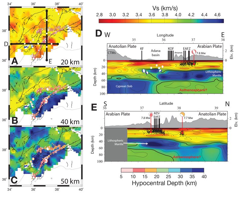
Map views (A–C) and cross sections (D, E) of S-wave velocity structure near the East Anatolian Fault Zone (EAFZ; Delph et al., 2017) with moment tensors and focal mechanisms from notable events since 1994 (Ergin et al., 2004; Dziewonski et al., 1981; Ekström et al., 2012) and seismicity from the 2023 earthquake sequence (Melgar et al., 2023) colored by hypocentral depth (map views) or black dots (cross sections). Note the fast (>4.4. km/s) S-wave velocities that extend from the Arabian mantle lithosphere northward to near the Mw 7.7 epicentral location. North of this region, upper mantle velocities indicate a thin-to-negligible lithospheric mantle thickness (<20 km) below a relatively thick crust (~45 km). BZS: Bitlis-Zagros Suture; CTMs: Central Taurus Mountains; KF: Kozan Fault; KOF: Karatas-Osmaniye Fault.
Mapping Velocity Variations to Lithospheric Strength
We calculate relatively simplistic lithospheric yield strength envelopes for representative profiles in the Anatolian and Arabian Plates near the EAFZ under the assumption that the velocity structure of the crust and upper mantle could be interpreted to represent variations in lithospheric strength (Fig. 3; details in Supplemental Material1). The Anatolian Plate in the study area is characterized by relatively slow S-wave velocities, crustal thicknesses of ~40–45 km, and a thin overall lithosphere (~60 km), whereas Arabia has a thinner crust (~30 km) and a slightly thicker lithosphere (~60–70 km) characterized by faster overall S-wave velocities (Abgarmi et al., 2017; Delph et al., 2017; Hua et al., 2020; Ogden and Bastow, 2022). Lithospheric thickness variations are also validated by constraints from pressure-temperature (P-T) equilibration of primitive mantle melts (Reid et al., 2017, 2019; Cosca et al., 2021) and provide constraints on the geothermal gradient of the lithosphere. Assuming a simple linear geotherm from the surface to the base of the lithosphere, we find that the Anatolian Plate is “weak” relative to the Arabian Plate. In other words, the strength envelope of Anatolia is dominated by ductile deformation at depths >~15 km due to its thinner overall lithosphere, thicker crust, and slightly elevated geotherm when compared to the Arabian Plate, which shows a strong lithospheric mantle between ~30–55 km.
-------
1 Supplemental Material. Explanation of the creation of the lithospheric strength profiles.
Table S1: Parameters used to calculate yield strength envelopes. Please visit https://doi.org/10.1130/GSAT.S.25927462 to access the supplemental material, and contact editing@geosociety.org with any questions.
Figure 3
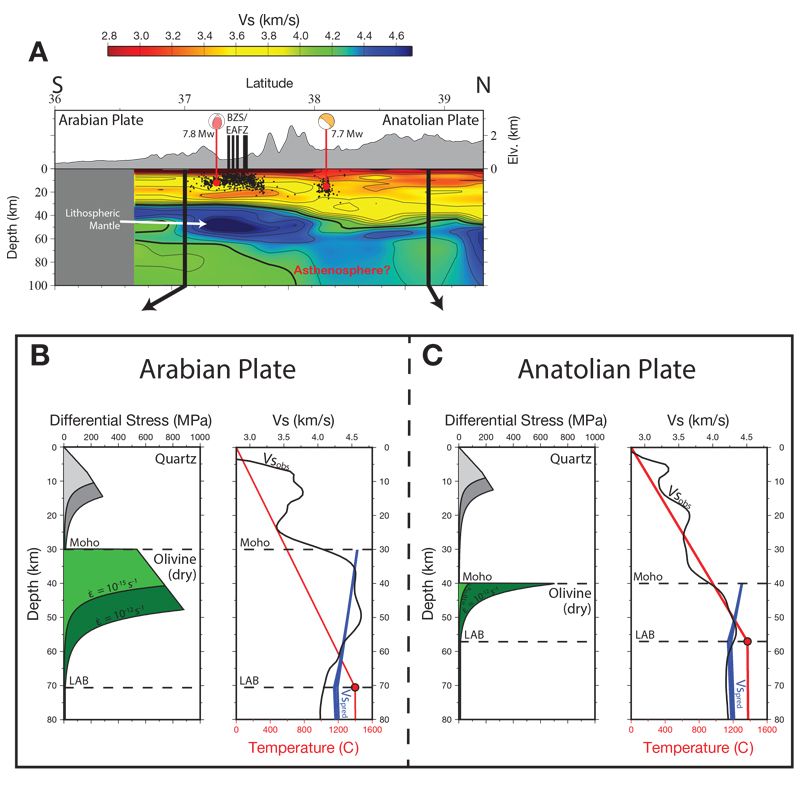
(A) Same as Figure 2E. (B, C) Strength (left) and S-wave velocity (right) profiles for locations in the Arabian and Anatolian Plates shown in (A). Strength panels: The Arabian Plate has a strong and relatively thick lithospheric mantle below a thin crust, whereas the Anatolian Plate has a thin and weak lithospheric mantle under a thick crust. Profiles include estimates of strength for strain rates at 10−15 s-1 (slow, light green) and 10−12 s-1 (fast, dark green). Vs panels: Red line represents a thermal profile extrapolated to the P-T conditions of the lithosphere-asthenosphere boundary (LAB) estimated from melt equilibria (Reid et al., 2019). S-wave velocity profiles from Delph et al. (2017) are shown with Vs predictions for peridotite. BZS: Bitlis-Zagros Suture; EAFZ: East Anatolian Fault Zone.
Predicted material properties for mantle peridotite can also be used to calculate seismic velocities, which agree well with observed lithospheric thicknesses and velocities, to first order. While the calculated values are higher than observed, the general character of the profiles is similar. For example, where the predicted velocities reach a minimum is generally in agreement with the observed S-wave velocity profiles and melt P-T estimates in the different regions (Figs. 3B, 3C). Thus, melt P-T estimates appear to be robust indicators of lithospheric thickness and agree with both predictions of mantle peridotite S-wave velocities and those recovered through seismic imaging (e.g., Reid et al., 2019), providing further evidence of a thicker and stronger lithospheric mantle below the Arabian Plate.
Therefore, there is strong evidence that the lithospheric structure near the EAFZ is characterized by the juxtaposition of the weaker crust and lithospheric mantle of the Anatolian Plate to the north with the stronger Arabian lithospheric mantle to the south at depths of ~30–45 km. This juxtaposition could lead to the concentration of stress that is transmitted to the surface, expressed in active fault geometries and patterns of seismicity. Whitney et al. (2023) interpret the arrival of this stronger Arabian lithosphere to coincide with the development of the EAFZ as a lithospheric-scale structure controlling the southern margin of the Anatolian escape system at ca. 5 Ma. Perhaps this indicates that the indentation of rigid Arabian Plate lithosphere into the Anatolian Plate (and in particular, lithospheric mantle indenting into a weak lower crust) acts as a strong spatial control on the concentration of deep plate boundary strain expressed in complex surface faulting and seismogenesis. This may explain why the Mw 7.7 earthquake and its aftershocks from the Kahramanmaraş sequence occurred above the inferred present-day location of underthrusting Arabian lithospheric mantle. Viscous deformation mechanisms are required to transmit this strain through the lower crust, perhaps via lower crustal flow if regional-scale pressure gradients exist (e.g., Karabulut et al., 2019) and/or through viscous drag exerted across the brittle-ductile transition.
Northward Migration of the Plate Boundary?
The collisional processes associated with development of escape tectonic regimes and the formation of a new plate are protracted and complex. However, seismic images, recent seismicity, and tectonic context provide insight into the future tectonic evolution of SE Anatolia. Of particular importance is the distribution of the fast-velocity anomaly interpreted as strong underthrusting Arabian mantle lithosphere, with a western boundary correlating with the deep seismicity below the Adana Basin, and the northern boundary below the northernmost seismicity of the 2023 Kahramanmaraş earthquake sequence along the SCFZ.
The Adana Basin may appear to be a region of subsidence due to its relatively thin crust and character as a depocenter for sediment accumulation, but it has experienced uplift rates of 0.07–0.13 mm/yr since ca. 5.3–5.2 Ma (Cipollari et al., 2013). Thus, basin development is enabled through differential uplift between the Adana Basin and surrounding mountain ranges. To the west, the Central Taurus Mountains (CTMs) have undergone much more rapid uplift (~0.45 mm/yr since 5.45 Ma), whereas the Amanos Mountains to the east have experienced ~0.2–0.4 mm/yr since ca. 3.7 Ma (Seyrek et al., 2008). CTM uplift is interpreted to be related to slab tearing/breakoff, perhaps from buoyant rebound of underthrusting African lithosphere (e.g., Schildgen et al., 2014; Abgarmi et al., 2017), and the Amanos Mountains are thought to result from a combination of underthrusting strong Arabian lithosphere and transpressional bends along the main strand of the EAFZ. However, Adana Basin uplift likely results from underthrusting of the Arabian lithosphere, which extends to just east of the Kozan Fault Zone (Fig. 2D), muted by transtension within a large pull-apart basin. These factors led to the broad topographic depression of the Adana Basin despite a lack of modern subsidence, and further provide evidence that it is associated with an area of diffuse triple junction deformation.
Farther east, the Arabian lithosphere extends below the Anatolian Plate to the SCFZ. The relative ~5 mm/yr northward motion of the Arabian Plate interior toward this region (Ergintav et al., 2023) places the northern edge of this fast-velocity anomaly very near the main strand of the EAFZ at the time that it became a lithospheric-scale structure at ca. 5 Ma (Whitney et al., 2023). Thus, the arrival of strong Arabian lithospheric mantle in concert with the geometry of preexisting structures in the (proto)Anatolian Plate may have initiated formation of the EAFZ as a plate-bounding structure. Given (1) the current location of the strong Arabian lithospheric mantle as delineated by fast S-wave velocities; (2) the SCFZ clearly accumulating strain in response to collision as indicated by the 2023 earthquake sequence; and (3) the relatively deep seismicity below the Adana Basin, we speculate that the main strand of the EAFZ between the Hatay and Kahramanmaraş Triple Junctions will be abandoned in the future to be replaced by a throughgoing lithospheric structure running from the central Adana Basin to the SCFZ and eventually the EAFZ where the faults intersect (Fig. 4).
Figure 4
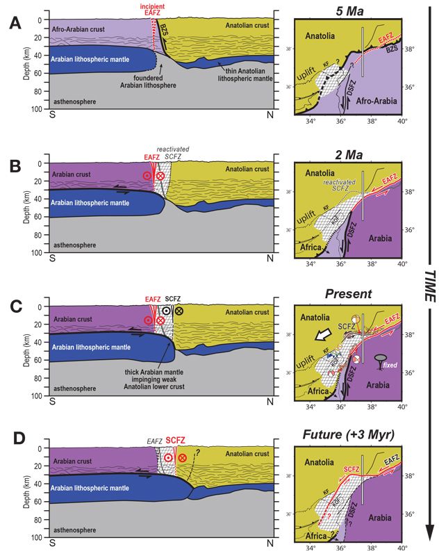
Conceptual evolution of the diffuse A3 Triple Junction area (white crosshatch pattern) from 5 Ma through the present to 3 Myr in the future. Red lines indicate dominant strain-accommodating branch of the East Anatolian Fault Zone (EAFZ). Gray lines on map views demarcate the location of the cross section. Mediterranean structures based on Aksu et al. (2021). (A) 5 Ma: The EAFZ became a plate-bounding structure accommodating the majority of strain related to collision. The position of the EAFZ was likely controlled by the location of rigid Arabian lithospheric mantle (Whitney et al., 2023). The A3 Triple Junction initially develops as the EAFZ links with the DSF. (B) 2 Ma: Northward motion of strong Arabian lithospheric mantle (re)activates the Sürgü-Çardak Fault Zone (SCFZ), which begins accommodating strain related to collision. (C) Present day: The SCFZ accommodates 1/3 of strain associated with collision, making it a candidate for large strain release through the seismic cycle. The SCFZ extends west and turns south to connect with deep seismicity below the Adana Basin, indicating it has developed to a throughgoing lithospheric structure. White arrow: Arabia-relative motion of Anatolia (Reilinger et al., 2006). (D) Predicted structure in 3 Myr: Northward motion of the strong Arabian lithospheric mantle forces the SCFZ to accommodate an increasing amount of strain relative to the EAFZ, becoming the dominant plate boundary structure in SE Anatolia. BZS: Bitlis Zagros Suture; DSF: Dead Sea Fault; KF: Kozan Fault; KOF: Karatas-Osmaniye Fault.
Acknowledgments
We thank U.S. Geological Survey reviewer N. Griffis and two anonymous reviewers for comments that improved this manuscript. We also thank W. Behr and L. Tokle for advice on the creation of the yield strength envelopes. Any use of trade, firm, or product names is for descriptive purposes only and does not imply endorsement by the U.S. government.
References
- Abgarmi, B., Delph, J.R., Ozacar, A.A., Beck, S.L., Zandt, G., Sandvol, E., Turkelli, N., and Biryol, C.B., 2017, Structure of the crust and African slab beneath the central Anatolian plateau from receiver functions: New insights on isostatic compensation and slab dynamics: Geosphere, v. 13, p. 1774–1787, https://doi.org/10.1130/GES01509.1.
- AFAD, 2018, The seismic hazard map of Turkey: Republic of Turkey, Prime Ministry Disaster and Emergency Management Presidency, http://tdth.afad.gov.tr/TDTH.
- Aksu, A.E., Hall, J., and Yaltırak, C., 2021, Miocene–Quaternary tectonic, kinematic and sedimentary evolution of the eastern Mediterranean Sea: A regional synthesis: Earth-Science Reviews, v. 220, https://doi.org/10.1016/j.earscirev.2021.103719.
- Burke, K., and Şengör, C., 1986, Tectonic escape in the evolution of the continental crust, in Barazangi, M., and Brown, L., eds., Reflection Seismology: The Continental Crust: Washington, D.C., American Geophysical Union, p. 41–53.
- Chorowicz, J., Luxey, P., Lyberis, N., Carvalho, J., Parrot, J., Yürür, T., and Gündogdu, N., 1994, The Maras Triple Junction (southern Turkey) based on digital elevation model and satellite imagery interpretation: Journal of Geophysical Research–Solid Earth, v. 99, p. 20,225–20,242, https://doi.org/10.1029/94JB00321.
- Cipollari, P., et al., 2013, Easternmost Mediterranean evidence of the Zanclean flooding event and subsequent surface uplift: Adana Basin, southern Turkey, in Robertson, A.H.F., Parlak, O., and Ünlügenç, U.C., eds., Geological Development of Anatolia and the Easternmost Mediterranean Region: Geological Society of LondonSpecial Publication 372, p. 473–493, https://doi.org/10.1144/SP372.5.
- Cosca, M.A., Reid, M., Delph, J.R., Kuşcu, G.G., Blichert-Toft, J., Premo, W., Whitney, D.L., Teyssier, C., and Rojay, B., 2021, Age and mantle sources of Quaternary basalts associated with “leaky” transform faults of the migrating Anatolia-Arabia-Africa triple junction: Geosphere, v. 17, p. 69–94, https://doi.org/10.1130/GES02266.1.
- Darin, M.H., and Umhoefer, P.J., 2022, Diachronous initiation of Arabia–Eurasia collision from eastern Anatolia to the southeastern Zagros Mountains since middle Eocene time: International Geology Review, v. 64, p. 2653–2681, https://doi.org/10.1080/00206814.2022.2048272.
- Delph, J.R., Abgarmi, B., Ward, K.M., Beck, S.L., Özacar, A.A., Zandt, G., Sandvol, E., Türkelli, N., and Kalafat, D., 2017, The effects of subduction termination on the continental lithosphere: Linking volcanism, deformation, surface uplift, and slab tearing in central Anatolia: Geosphere, v. 13, p. 1788–1805, https://doi.org/10.1130/GES01478.1.
- Dewey, J.F., Hempton, M.R., Kidd, W.S.F., Saroglu, F., and Şengör, A.M.C., 1986, Shortening of continental lithosphere: The neotectonics of Eastern Anatolia—A young collision zone, in Coward, M.P., and Ries, A.C., eds., Collision Tectonics: Geological Society of London Special Publication 19, p. 1–36, https://doi.org/10.1144/GSL.SP.1986.019.01.01.
- Duman, T.Y., and Emre, Ö., 2013, The East Anatolian Fault: Geometry, segmentation and jog characteristics, in Robertson, A.H.F. ,Parlak, O., Ünlügenç, U.C., eds., Geological Development of Anatolia and the Easternmost Mediterranean Region: Geological Society of London Special Publication 372, p. 495–529, https://doi.org/10.1144/SP372.14.
- Dziewoński, A.M., Chou, T.‐A., and Woodhouse, J.H., 1981, Determination of earthquake source parameters from waveform data for studies of global and regional seismicity: Journal of Geophysical Research–Solid Earth, v. 86, p. 2825–2852, https://doi.org/10.1029/JB086iB04p02825.
- Ekström, G., Nettles, M., and Dziewoński, A.M., 2012, The global CMT project 2004–2010: Centroid-moment tensors for 13,017 earthquakes: Physics of the Earth and Planetary Interiors, v. 200–201, p. 1–9, https://doi.org/10.1016/j.pepi.2012.04.002.
- Ergin, M., and Aktar, M., 2018, Lower crustal seismic activity in the Adana basin (Eastern Mediterranean): Possible connection to gravitational flexure: Tectonophysics, v. 730, p. 1–10, https://doi.org/10.1016/j.tecto.2018.02.015.
- Ergin, M., Aktar, M., and Eyidogan, H., 2004, Present-day seismicity and seismotectonics of the Cilician Basin: Eastern Mediterranean region of Turkey: Bulletin of the Seismological Society of America, v. 94, p. 930–939, https://doi.org/10.1785/0120020153.
- Ergintav, S., Floyd, M., Paradissis, D., Karabulut, H., Vernant, P., Masson, F., Georgiev, I., Konca, A.Ö., Doğan, U., King, R., and Reilinger, R., 2023, New geodetic constraints on the role of faults and blocks versus distributed strain in the Nubia-Arabia-Eurasia zone of active plate interactions: Turkish Journal of Earth Sciences, v. 32, p. 248–261, https://doi.org/10.55730/1300-0985.1842.
- Faccenna, C., Becker, T.W., Jolivet, L., and Keskin, M., 2013, Mantle convection in the Middle East: Reconciling Afar upwelling, Arabia indentation and Aegean trench rollback: Earth and Planetary Science Letters, v. 375, p. 254–269, https://doi.org/10.1016/j.epsl.2013.05.043.
- Gunasekera, R., et al., 2023, Global Rapid Post-Disaster Damage Estimation (GRADE) Report: February 6, 2023 Kahramanmaras Earthquakes: Türkiye Report: Washington, D.C., World Bank Group, 50 p.
- Hua, J., Fischer, K.M., Wu, M., and Blom, N.A., 2020, New approaches to multifrequency Sp stacking tested in the Anatolian region: Journal of Geophysical Research–Solid Earth, v. 125, no. 11, https://doi.org/10.1029/2020JB020313.
- Karabulut, H., Paul, A., Ozbakir, A.D., Ergün, T., and Şentürk, S., 2019, A new crustal model of the Anatolia-Aegean domain: Evidence for the dominant role of isostasy in the support of the Anatolian plateau: Geophysical Journal International, v. 218, p. 57–73, https://doi.org/10.1093/gji/ggz147.
- Kaymakcı, N., Inceöz, M., and Ertepinar, P., 2006, 3D-architecture and Neogene evolution of the Malatya Basin: Inferences for the kinematics of the Malatya and Ovacik fault zones: Turkish Journal of Earth Sciences, v. 15, p. 123–154.
- Kounoudis, R., Bastow, I.D., Ogden, C.S., Goes, S., Jenkins, J., Grant, B., and Braham, C., 2020, Seismic tomographic imaging of the Eastern Mediterranean mantle: Implications for terminal‐stage subduction, the uplift of Anatolia, and the development of the North Anatolian Fault: Geochemistry, Geophysics, Geosystems, v. 21, https://doi.org/10.1029/2020GC009009.
- Lyberis, N., Yurur, T., Chorowicz, J., Kasapoglu, E., and Gundogdu, N., 1992, The East Anatolian Fault: An oblique collisional belt: Tectonophysics, v. 204, p. 1–15, https://doi.org/10.1016/0040-1951(92)90265-8.
- Mahmoud, Y., et al., 2013, Kinematic study at the junction of the East Anatolian fault and the Dead Sea fault from GPS measurements: Journal of Geodynamics, v. 67, p. 30–39, https://doi.org/10.1016/j.jog.2012.05.006.
- Melgar, D., et al., 2023, Sub- and super-shear ruptures during the 2023 Mw 7.8 and Mw7.7 earthquake doublet in SE Türkiye: Seismica, v. 2, p. 1–10, https://doi.org/10.26443/seismica.v2i3.387.
- Molnar, P., and Tapponnier, P., 1981, A possible dependence of tectonic strength on the age of the crust in Asia: Earth and Planetary Science Letters, v. 52, p. 107–114, https://doi.org/10.1016/0012-821X(81)90213-2.
- OCHA, 2023, Türkiye: 2023 Earthquakes: United Nations Office for the Coordination of Humanitarian Affairs Situation Report No. 17, 8 p.
- Ogden, C.S., and Bastow, I.D., 2022, The crustal structure of the Anatolian Plate from receiver functions and implications for the uplift of the central and eastern Anatolian plateaus: Geophysical Journal International, v. 229, p. 1041–1062, https://doi.org/10.1093/gji/ggab513.
- Okay, A.I., and Satir, M., 2000, Coeval plutonism and metamorphism in a latest Oligocene metamorphic core complex in northwest Turkey: Geological Magazine, v. 137, p. 495–516, https://doi.org/10.1017/S0016756800004532.
- Over, S., Kavak, K.Ş., Bellier, O., and Özden, S., 2004, Is the Amik Basin (SE Turkey) a triple-junction area? Analyses of SPOT XS imagery and seismicity: International Journal of Remote Sensing, v. 25, p. 3857–3872, https://doi.org/10.1080/01431160310001654437.
- Özkan, A., Yavaşoğlu, Hasan H.H., and Masson, F., 2023, Present-day strain accumulations and fault kinematics at the Hatay Triple Junction using new geodetic constraints: Tectonophysics, v. 854, https://doi.org/10.1016/j.tecto.2023.229819.
- Portner, D.E., Delph, J.R., Biryol, C.B., Beck, S.L., Zandt, G., Özacar, A.A., Sandvol, E., and Türkelli, N., 2018, Subduction termination through progressive slab deformation across Eastern Mediterranean subduction zones from updated P-wave tomography beneath Anatolia: Geosphere, v. 14, p. 907–925, https://doi.org/10.1130/GES01617.1.
- Reid, M.R., Schleiffarth, W.K., Cosca, M.A., Delph, J.R., Blichert-Toft, J., and Cooper, K.M., 2017, Shallow melting of MORB-like mantle under hot continental lithosphere, Central Anatolia: Geochemistry, Geophysics, Geosystems, v. 18, https://doi.org/10.1002/2016GC006772.
- Reid, M.R., Delph, J.R., Cosca, M.A., Schleiffarth, W.K., and Kuşcu, G., 2019, Melt equilibration depths as sensors of lithospheric thickness during Eurasia-Arabia collision and the uplift of the Anatolian plateau: Geology, v. 47, p. 943–947, https://doi.org/10.1130/G46420.1.
- Reilinger, R., et al., 2006, GPS constraints on continental deformation in the Africa-Arabia-Eurasia continental collision zone and implications for the dynamics of plate interactions: Journal of Geophysical Research–Solid Earth, v. 111, no. B5, https://doi.org/10.1029/2005JB004051.
- Schildgen, T.F., Yıldırım, C., Cosentino, D., and Strecker, M.R., 2014, Linking slab break-off, Hellenic trench retreat, and uplift of the Central and Eastern Anatolian plateaus: Earth-Science Reviews, v. 128, p. 147–168, https://doi.org/10.1016/j.earscirev.2013.11.006.
- Schleiffarth, W.K., Darin, M.H., Reid, M.R., and Umhoefer, P.J., 2018, Dynamics of episodic Late Cretaceous–Cenozoic magmatism across Central to Eastern Anatolia: New insights from a comprehensive geochronology compilation: Geosphere, v. 14, p. 1990–2008, https://doi.org/10.1130/GES01647.1.
- Şengör, A.M.C., Görür, N., and Saroglu, F., 1985, Strike-slip faulting and related basin formation in zones of tectonic escape: Turkey as a case study, in Biddle, K., and Christie-Blick, N., eds., Strike-Slip Deformation, Basin Formation and Sedimentation: Tulsa, Oklahoma, SEPM (Society for Sedimentary Geology), p. 227–264, https://doi.org/10.2110/pec.85.37.0227.
- Seyrek, A., Demir, T., Pringle, M., Yurtmen, S., Westaway, R., Bridgland, D., Beck, A., and Rowbotham, G., 2008, Late Cenozoic uplift of the Amanos Mountains and incision of the Middle Ceyhan river gorge, southern Turkey: Ar-Ar dating of the Düziçi basalt: Geomorphology, v. 97, p. 321–355, https://doi.org/10.1016/j.geomorph.2007.08.014.
- Stein, R., Today, S., Özbakir, A.D., Sevilgen, V., Gonzalez-Huizar, H., Lotto, G., and Sevilgen, S., 2023, Interactions, stress changes, mysteries, and partial forecasts of the 2023 Kahramanmaraş, Türkiye, earthquakes: Temblor, http://doi.org/10.32858/temblor.299.
- Tapponnier, P., Peltzer, G., Le Dain, A.Y., Armijo, R., and Cobbold, P., 1982, Propagating extrusion tectonics in Asia: New insights from simple experiments with plasticine: Geology, v. 10, p. 611–616, https://doi.org/10.1130/0091-7613(1982)10<611:PETIAN>2.0.CO;2.
- Umhoefer, P.J., Thomson, S.N., Lefebvre, C., Cosca, M.A., Teyssier, C., and Whitney, D.L., 2020, Cenozoic tectonic evolution of the Ecemiş fault zone and adjacent basins, central Anatolia, Turkey, during the transition from Arabia-Eurasia collision to escape tectonics: Geosphere, v. 16, p. 1358–1384, https://doi.org/10.1130/GES02255.1.
- Westaway, R., 2004, Kinematic consistency between the Dead Sea Fault Zone and the Neogene and Quaternary left-lateral faulting in SE Turkey: Tectonophysics, v. 391, p. 203–237, https://doi.org/10.1016/j.tecto.2004.07.014.
- Whitney, D.L., et al., 2023, Breaking plates: Creation of the East Anatolian fault, the Anatolian plate, and a tectonic escape system: Geology, v. 51, p. 673–677, https://doi.org/10.1130/G51211.1.
