
Active Fault Database for the Northern Western Branch of the East African Rift System
Hillary Mwongyera et al.

In this article
Authors
Hillary Mwongyera*
Department of Geology, University of Kansas, Lawrence, Kansas, 66045 USA; Department of Geology and Petroleum Studies, Makerere University, Kampala, Uganda
Michael H. Taylor
Department of Geology, University of Kansas, Lawrence, Kansas, 66045 USA
D. Sarah Stamps
Department of Geosciences, Virginia Tech, Blacksburg, Virginia, 24061 USA
Estella A. Atekwana
Department of Earth and Planetary Sciences, University of California Davis, Davis, California 95616, USA
Rob L. Evans
Department of Geology and Geophysics, Woods Hole Oceanographic Institution, Falmouth, Massachusetts, 02543 USA
Peter H. Barry
Department of Marine Chemistry and Geochemistry, Woods Hole Oceanographic Institution, Falmouth, Massachusetts, 02543 USA
Suzan van der Lee
Department of Earth, Environmental and Planetary Sciences, Northwestern University, Evanston, Illinois, 60208 USA
Andrew Katumwehe
Boone Pickens School of Geology, Oklahoma State University, Stillwater, Oklahoma, 74075 USA
Emmanuel Njinju
Department of Geosciences, Baylor University, Waco, Texas, 76706 USA
Albert Kabanda
Department of Earth, Environmental and Planetary Sciences, Northwestern University, Evanston, Illinois, 60208 USA
Asenath Kwagalakwe
Department of Geological Sciences, California State University, Northridge, California, 91330 USA
John Mary Kiberu
Department of Geology and Petroleum Studies, Makerere University, Kampala, Uganda
Joan Nakajigo
Department of Geology and Petroleum Studies, Makerere University, Kampala, Uganda
Fred Tugume
Directorate of Geological Survey and Mines, Entebbe, Uganda
Abstract
The northern Western Branch of the East African Rift System (EARS) is characterized by active normal faults accommodating extension and locally, fault propagation along rift-bounding structures. We present an active fault database synthesizing structural geology, fault geometry and kinematics, field mapping observations, seismicity, and references to previous literature. The database represents a significant step toward understanding recent fault slip patterns, earthquake recurrence, and fault interaction. From south to north, the northern Western Branch of the EARS is composed of the Edward George Rift, the Albertine Rift, and the Rhino Graben, which exhibits contrasting rifting styles with distinct lateral variations in fault geometry and fault kinematics. Rifting within the Edward George Rift is widely accepted to be magmatic-driven, with rift-bounding faults striking predominantly N-NE, consistent with the orientation of Bunyaruguru and Katwe-Kikorongo volcanic fields. Intrabasin active normal faults form closely spaced fault zones that reorganize active stream channels draining into Lakes Edward and George. To the north, the magma-poor Albertine Rift is defined by NE-striking border faults indicating sustained extension in a presumably cold cratonic lithosphere, but a shift to NW-striking faults along the Butiaba Wanseko Transfer Zone suggests oblique extension. Farther north, the Rhino Graben is characterized by right-stepping, en echelon normal faults indicative of along-strike strain partitioning. This study integrates geomorphic, structural, and geophysical observations to document active faults along the northern Western Branch of the EARS, highlighting the potential roles of magmatism and inherited lithospheric structures during continental breakup.
*hillary.mwongyera@mak.ac.ug
CITATION: Mwongyera, H., et al., 2026, Active Fault Database for the Northern Western Branch of the East African Rift System: GSA Today, v. 36, no. 8 p. 4–11, https://doi.org/10.1130/GSATG634A.1.
© 2026 The Authors. Gold Open Access: This paper is published under the terms of the CC-BY-NC license. Printed in the USA.
Introduction
The East African Rift System (EARS) is a divergent plate boundary and natural laboratory for understanding continental breakup, with its trace bifurcating around the Tanzania Craton, establishing the Eastern and Western Branches characterized by apparent differences in seismicity and volcanism (Fig. 1A; Ebinger, 1989). Active rift extension is driven by eastward divergence of the Somali Plate from the stable Nubian Plate, causing lithospheric thinning and weakening essential for rift initiation (e.g., Stamps et al., 2014).
One prominent model for continental breakup emphasizes magma-assisted rifting, in which magmatism plays a primary role in facilitating rift extension, as manifested along the Eastern Branch of the EARS (Muirhead et al., 2016; Biggs et al., 2021). However, magma-poor rifts of the Western Branch of the EARS challenge the above model, revealing continental breakup in the absence of substantial magmatism, with mechanisms facilitating strain localization, lithospheric thinning, and rift propagation poorly understood.
While previous active fault mapping studies in the Malawi (Williams et al., 2022), Luangwa (Wedmore et al., 2022), and Kivu Rifts (Delvaux et al., 2017) provide insights into continental breakup along the Western Branch of the EARS, enhancing our understanding of its neotectonic evolution, the geometry and kinematics of active faults along the northern Western Branch of the EARS remain poorly documented. This study addresses this gap by developing a comprehensive database that consolidates spatial, kinematic, and temporal data on active fault geometry and kinematics along the northern Western Branch of the EARS.
Recent active fault mapping studies along the northern Western Branch of the EARS have focused on individual rift segments, such as the Edward George Rift (e.g., Wedmore et al., 2024). This fault database integrates geospatial data on active faults and inherited structures in the Edward George Rift, the Albertine Rift, and the Rhino Graben into a unified framework, revealing along-axis variations from magma-assisted to magma-poor rifting while providing insights into continental rift termination against a rigid basement block.
This database integrates field observations, neotectonic maps, remote sensing data, seismicity, and published literature, providing a better understanding of active faults and the complex interactions driving tectonic deformation (e.g., Veloza et al., 2012). The relationship between fault kinematics and earthquake focal mechanisms is critical for understanding the distribution of fault slip and strain localization to help in seismic forecasting, assessing risks, and developing effective mitigation strategies (Taylor and Yin, 2009).
Figure 1
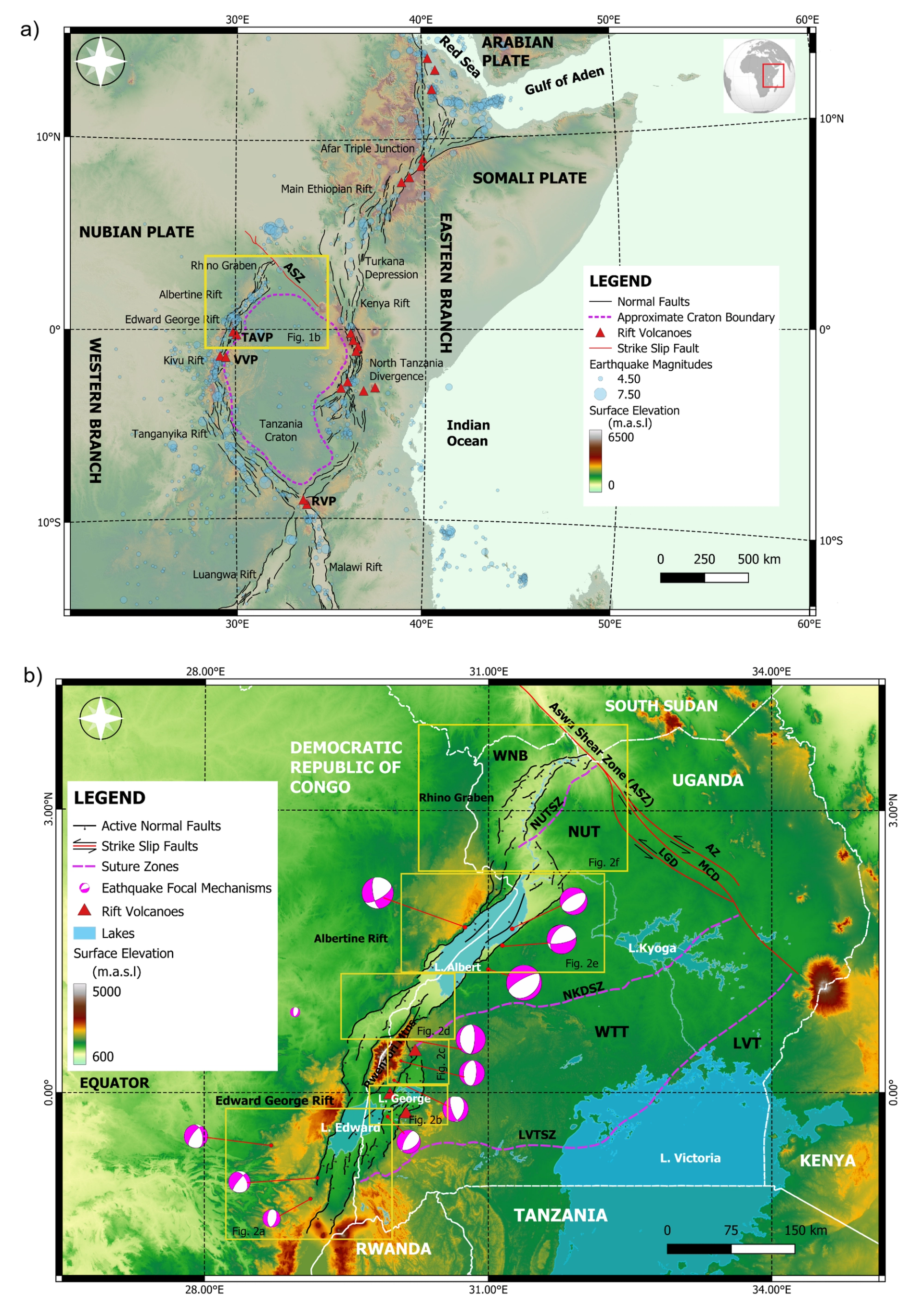
(A) Digital elevation map of the continental East African Rift System (EARS) showing fault traces, volcanic centers, and earthquake epicenters (scaled by magnitude). The magma-poor Western Branch, which hosts the TAVP (Toro-Ankole), VVP (Virunga), and RVP (Rungwe) volcanic provinces, is more seismically active than the magmatic Eastern Branch. Note the cluster of earthquakes north of the Aswa Shear Zone (ASZ). (B) Neotectonic map of the NW Branch of the Cenozoic EARS, showing the spatial distribution of active normal faults (black lines), strike-slip faults (red lines with black arrows), suture zones (purple dashed lines), earthquake focal mechanisms (pink beach balls), and Cenozoic volcanism (red triangles). Fault-bounded domains within the ASZ include: LGD—Lira-Gulu Domain; MCD—Main Central Domain; AZ—Amuria Zone ; WNB—West Nile Block; NUT—Northern Uganda Terrane; SZ—Suture Zone; NKD—Nakasongola Discontinuity; WTT—West Tanzania Terrane; LVT—Lake Victoria Terrane. (Saalmann et al., 2016).
Geological Setting
Pre-Cenozoic Tectonic Setting of Uganda
The pre-Cenozoic tectonic setting of Uganda was mainly established by the East African Orogeny (EAO), a major continental collisional event associated with the final amalgamation of Gondwana, during which juvenile arc terranes, microcontinents, and older cratonic fragments were sutured together (Fritz et al., 2013). The continental collision formed Proterozoic suture zones between crustal blocks assembled during the Neoproterozoic EAO between ~650–550 Ma (Stern, 1994). The emplacement of post-collisional potassic and metaluminous granitoids across the Late Neoproterozoic EAO was a multiphase and diachronous process, with the earliest magmatic pulse occurring concurrently with high-temperature granulite-facies metamorphism and amphibolite-facies retrogression between 590 and 550 Ma (Küster and Harms, 1998). Subsequent post-orogenic deformation is recorded by the development of multiple shear zones that transect the Ugandan basement complex, which were last active between ~500 and 400 Ma based on U-Pb geochronology (Leggo, 1974).
Suture zones separate the major tectonic domains of Uganda that include the West Nile Block (WNB), Northern Uganda Terrane (NUT), West Tanzania Terrane (WTT), and the Lake Victoria Terrane (LVT; Westerhof et al., 2014). The Lake Victoria Suture Zone (LVTSZ), separating the WTT from the LVT, forms a localized zone of structural inheritance in the southern portion of the northern Western Branch of the EARS. The Nakasongola Discontinuity Suture Zone (NKDSZ) separates the WTT from the NUT, marking a prominent NE-striking crustal discontinuity across central Uganda (Ruotoistenmäki, 2014). Finally, the Northern Uganda Terrane Suture Zone (NUTSZ) marks the Proterozoic boundary between the WNB and the NUT (Westerhof et al., 2014).
Late Cenozoic Development of the EARS
The timing of Cenozoic rift extension provides a framework for understanding contrasting rifting styles between the Eastern and Western Branches of the EARS. In the Eastern Branch, radiometric ages reveal that rifting initiated at ~35 Ma along the Main Ethiopian Rift, propagating southward along the Kenya Rift at 30–25 Ma, culminating at the North Tanzania Divergence and the Nyanza Rift at 20–18 Ma (Michon et al., 2022). The formation of the Western Branch occurred along the Malawi Rift around 19–17 Ma, propagating northward to the Tanganyika and Kivu Rifts at 11 Ma, based on recent compilations of isotopic crystallization ages on volcanic rocks (Martin, 2023).
However, previous studies have challenged the prevailing view of diachronous rifting between the Eastern and Western Branches of the EARS. Detrital zircon geochronology and sedimentological field observations support the interpretation that rifting in the Western Branch commenced earlier than previously thought, initiating extension contemporaneously with the Eastern Branch (Roberts et al., 2012).
The disparity in volcanism between the Eastern and Western Branches of the EARS is attributed to mantle plume deflection beneath the Tanzania craton, which redirects the plume toward the eastern segment of the EARS (Koptev et al., 2016). This eastward deflection of the plume is believed to have strongly weakened, deformed, and localized extension of the lithosphere on the craton’s eastern side (Glerum et al., 2020).
Figure 2
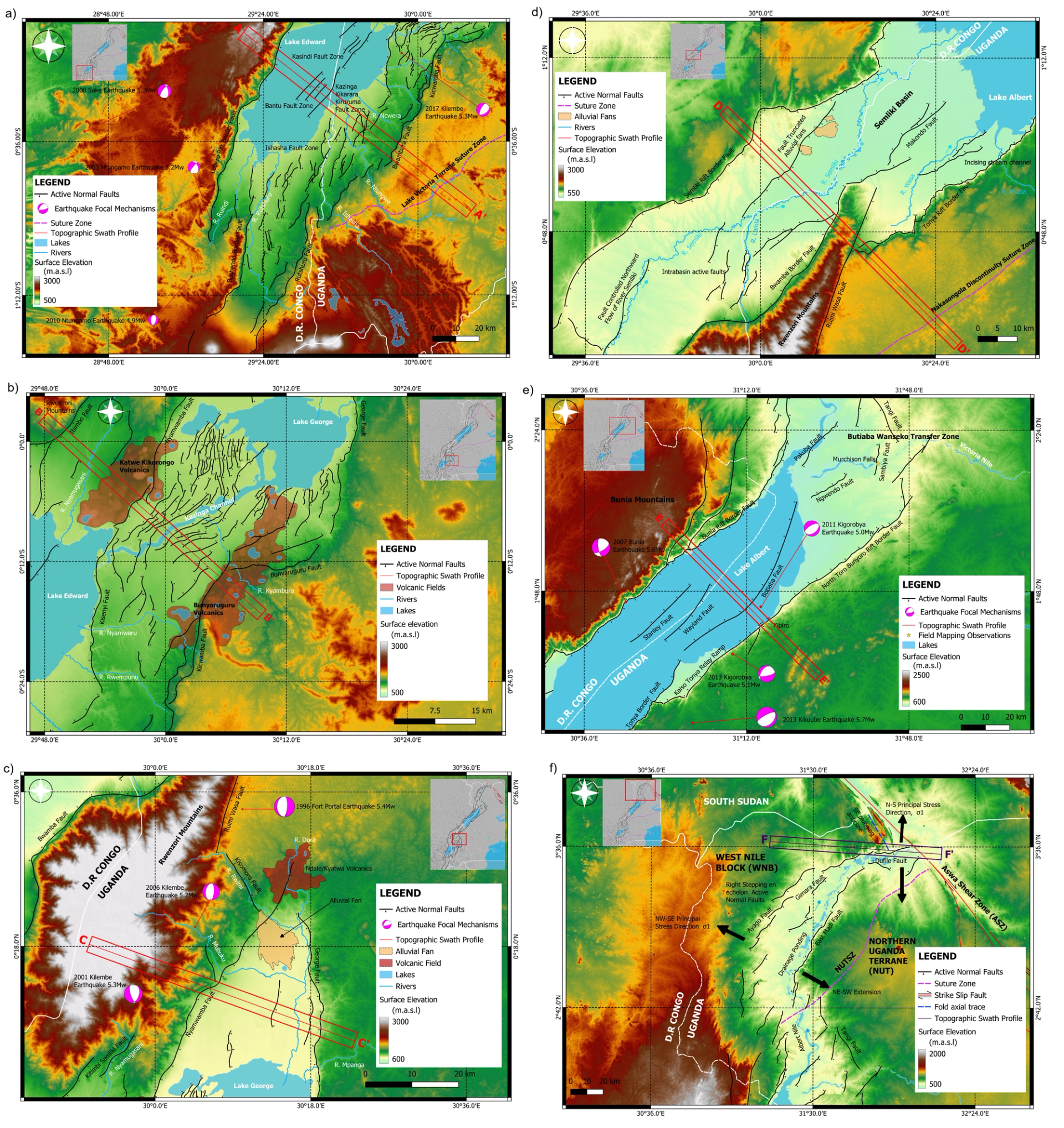
Neotectonic maps showing active faults, earthquake focal mechanisms, and swath profiles in the Edward George Rift (A–C), Albertine Rift (D–E), and Rhino Graben (F). See Figure 1B for location.
Materials and Methods
Data Sources and Active Fault Mapping
We utilized satellite imagery, 30-m SRTM digital elevation models (DEMs), hillshade, and slope maps to observe the tonal and topographic expression of active faults dissecting the landscape across the entire northern Western Branch of the EARS. We identified fault scarps and deformed landforms, including fault-truncated alluvial fans, volcanic craters, and deflected stream channels. Field mapping observations were made at selected sites to validate kinematic evidence of active faulting. Topographic swath profiles were utilized to visualize topographic expression along active faults and estimate vertical separation magnitudes (Hoxey et al., 2024). Data from the USGS earthquake catalog (https://earthquake.usgs.gov/earthquakes/search/) were utilized to compare seismicity with active fault geometry and kinematics.
Database Structure and Design
The active fault database for the northern Western Branch of EARS is designed using ESRI shapefile format and refined to include KML and GeoJSON data formats, assisting potential users in academia, industry, and government. The database enhances user accessibility and integration with various mapping applications, such as Google Earth and Generic Mapping Tools, for broader geospatial analysis (e.g., Styron et al., 2010). The database will be regularly updated and is hosted on Zenodo (Mwongyera and Taylor, 2025), an open-access platform that ensures accessibility, visibility, and version control, facilitating data sharing and collaboration among researchers, educators, and the broader scientific community.
Figure 3
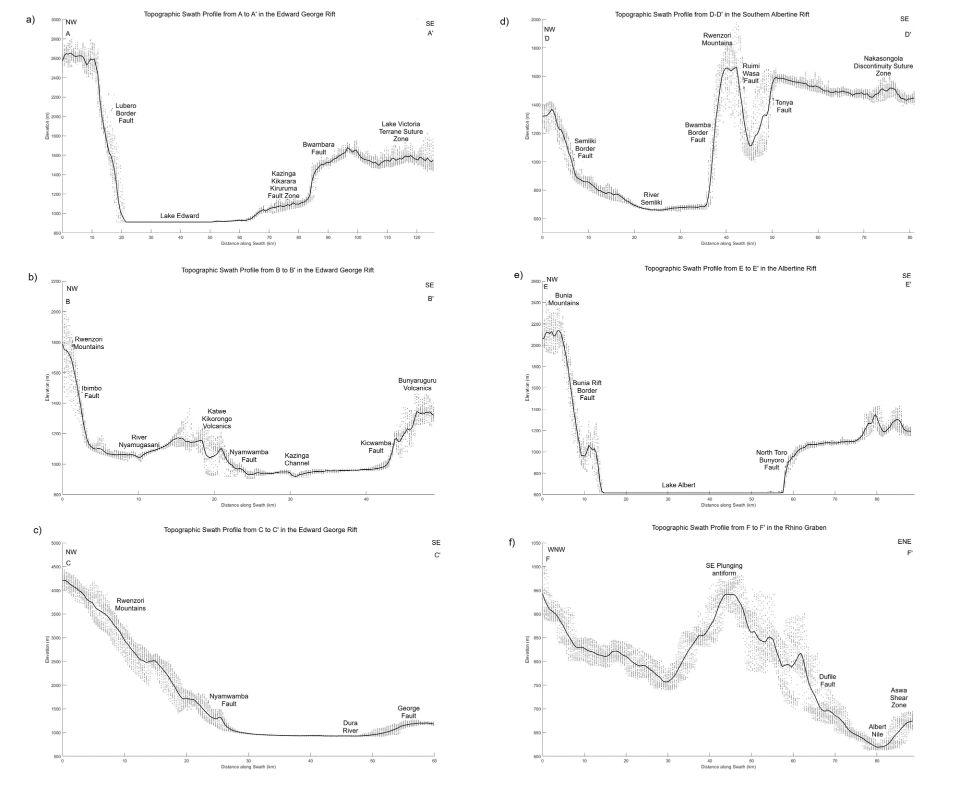
Topographic swath profiles across the Edward George Rift (A–C), Albertine Rift (D–E), and Rhino Graben (F), highlighting uplifted flanks, rift asymmetry, and fault-controlled topography.
Results
The Edward George Rift
The Edward George Rift is bounded by active normal faults whose strike geometry is consistent with the orientation of Bunyaruguru and Katwe-Kikorongo volcanic fields (Fig. 2B). Intrabasin deformation is accommodated by closely spaced N-NE–striking intrabasin faults that cluster to form major fault zones, namely, Kazinga Kikarara Kiruruma and Ishasha fault zones (Nicholas, 2025; Fig. 2A). Offshore beneath Lake Edward, the Kasindi and Bantu fault zones are prominent intrabasin structures. Topographic swath profiles (A-A′ and B-B′) reveal rift asymmetry with significant relief between the subsiding basin floor and the uplifted rift flanks, reflecting the dominance of border fault systems concentrating slip (Figs. 3A and 3B).
The Rwenzori Mountains and Semliki Basin
The Rwenzori Mountains exhibit a complex pattern of active faults influenced by extensional tectonics, tectonic uplift, and deep-seated lithospheric processes. The C-C′ swath profile reveals a steep descent from the Rwenzori horst (>4000 m), with a steep southeastern flank defined by the Nyamwamba Fault transitioning to a broad subsiding basin floor followed by a gentle rise across the George Fault (Fig. 3C). The D-D′ swath profile illustrates a graben-horst geometry, with the Rwenzori Horst bounded by the Bwamba and Ruimi Wasa Faults, and a sharp rise near the NKDSZ that dictates active fault strike geometry toward the Albertine Rift (Fig. 3D).
The Albertine Rift
The Albertine Rift is characterized by long, linear NE-striking active rift-bounding faults (Tonya, Bunia and North Toro Bunyoro) that define the graben extent (Fig. 2E). Offshore faults (Stanley, Wayland, and Butiaba) display similar kinematics to border faults, reflecting distributed extension toward the basin interior (Karp et al., 2012). Swath profile E-E′ reveals rift asymmetry, with dominant slip along the Bunia Fault compared to the North Toro Bunyoro Fault (Fig. 3E).
The Rhino Graben
The Rhino Graben features dominantly NE-striking en echelon normal faults, with an abrupt change in E-W fault geometry in the north. The shift in geometry remains unclear, but we discuss possible mechanisms in the following section.
Figure 4
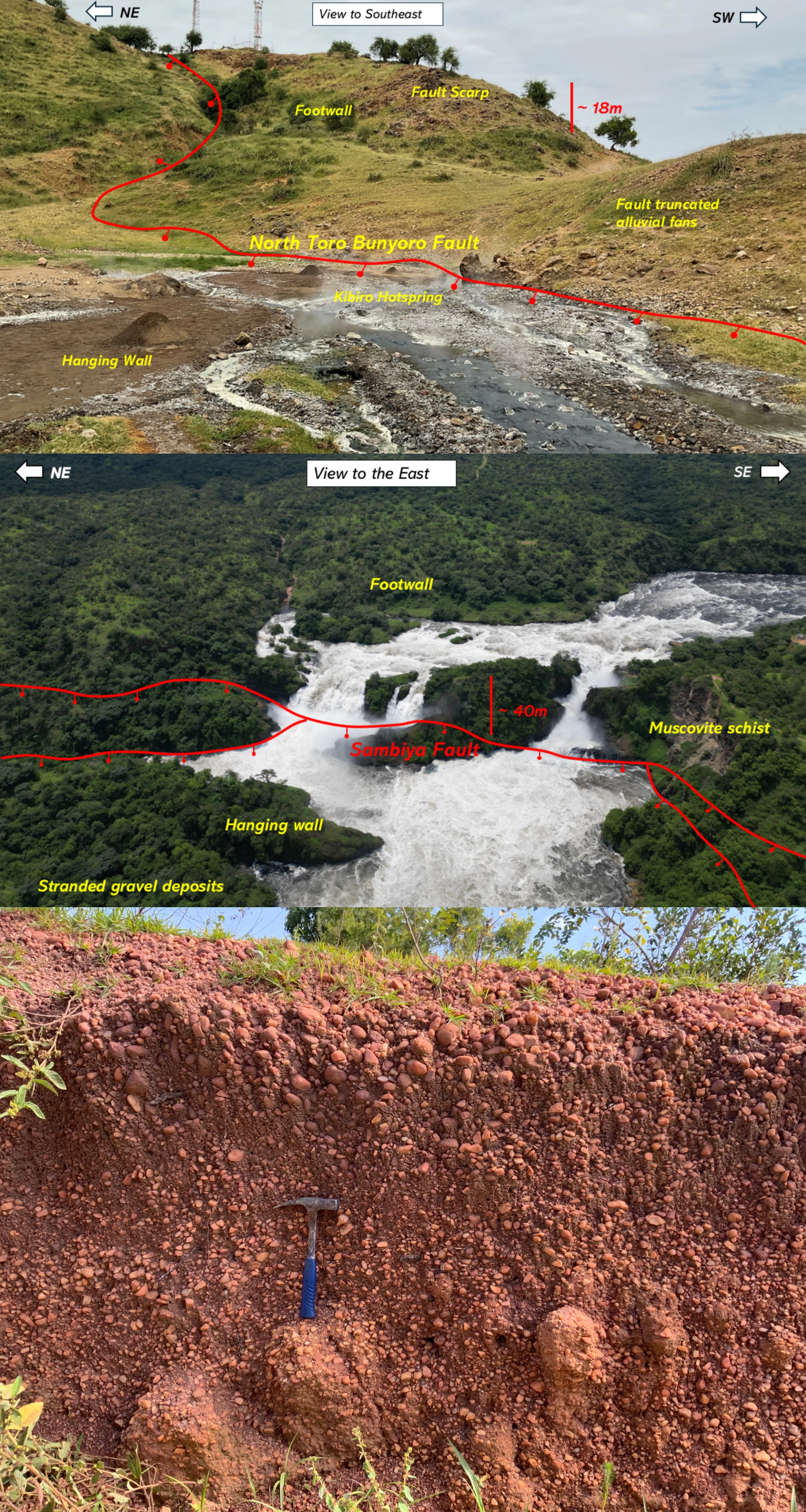
(A) Field photo of the North Toro Bunyoro Fault scarp at Kibiro, Albertine Rift, showing an active hot spring and fault-truncated alluvial fans as geomorphic evidence of active faulting. (B) Fault-controlled knickpoint at Murchison Falls along the Sambiya Fault (C) stranded gravel deposits in the hanging wall.
Discussion
Potential Lithospheric Processes Associated with Active Faults
In the Edward George Rift, volcanic craters in the Katwe-Kikorongo and Bunyaruguru volcanic fields are oriented along strike of the Kicwamba and Nyamwamba Faults, suggesting a genetic relationship between magmatism and active faulting (Lærdal and Talbot, 2002). Intrabasin active normal faults form in a thermally weakened lithosphere characterized by a shallow low-velocity zone, suggesting the presence of melt at depth (e.g., Wedmore et al., 2024).
North of the Edward George Rift, the Rwenzori Horst, bounded by steep normal faults, has experienced sustained uplift at 1–2 mm/yr during the past ~2 Ma, with its morphology further shaped by erosion and glaciation (Kaufmann et al., 2016).
Magmatic intrusions beneath the Rwenzori region create crustal heterogeneities and thermally weaken the lithosphere (Batte and Rümpker, 2019), potentially promoting distributed deformation and slip along normal faults bounding the Rwenzori horst. Normal fault slip around the Rwenzori horst is evidenced by kinematic indicators, including fault striations showing a normal sense of shear and steep plunges consistent with dip-slip motion along the Bwamba Fault (Hollinsworth et al., 2019). The Nyamwamba fault truncates tuff deposits of the Ndale volcanic field, dated ~4–5 ka (Hogarth and Horne, 1989), suggesting that faulting postdates emplacement of volcanic tuffs (Fig. 2C).
To the north, the Albertine Rift exhibits high-angle NE-striking border faults, with prominent escarpments reflecting localized footwall uplift (Figs. 2E and 3E). While the rift-bounding faults delineate the Albertine Rift and accommodate larger vertical displacements, the offshore fault systems represent smaller-scale, secondary structures localizing extension toward the basin interior.
The Tonya and North Toro Bunyoro Faults are linked by an oblique normal fault along the Kaiso-Tonya relay ramp, while the Bunia Fault bifurcates into synthetic fault splays oblique to the major fault trace, akin to a horsetail with trailing branchlines (Fig. 2E).
The predominant NE-striking fault geometry in the central and southern Albertine Rift shifts to a NW-striking geometry toward the northern section near the Butiaba Wanseko Transfer Zone (Fig. 2E). This change in geometry is notably observed along the NW-striking Tangi Fault near Murchison Falls, possibly due to oblique extension.
Farther north, the Rhino Graben is characterized by en echelon active normal faults with their strike geometry consistent with the orientation of the NUTSZ (Fig. 2F). The en echelon faults are kinematically linked, suggesting that motion on one fault directly affects the propagation of adjacent faults, thereby redistributing strain (Faulds and Varga, 1998). At the northern end of the Rhino Graben, active fault strike geometry shifts from NE to nearly E-W, aligning with trending aeromagnetic fabric interpreted as Precambrian structures influencing the graben’s map pattern (Katumwehe et al., 2015). Additionally, en echelon active faults may indicate extensional obliquity relative to changes in regional extension direction (Fig. 2F; Zwaan et al., 2016.) This observation is consistent with the interpretation that vertical-axis rotations cause rift segments to propagate bidirectionally rather than unidirectionally (Zwaan and Schreurs, 2020).
Geomorphic Expression of Active Faulting and Local Volcanism
Geomorphic evidence of active faulting along the northern Western Branch of EARS is expressed in the form of fault scarps, triangular facets, deformed landforms (e.g., alluvial fan and Holocene craters), and stream anomalies (e.g., deflected, incised).
In the Edward George Rift, active stream channels dominantly flow parallel to the strike of intrabasin normal faults (Figs. 2A–2C). Active drainage channels, notably Ishasha, Rutshuru, Ruindi, Ntungwe, and Ncwera Rivers, flow along strike of intrabasin faults and are thus fault-controlled (Fig. 2A).
The morphology of the Kazinga Channel connecting Lakes Edward and George is influenced by active NE-SW–striking intrabasin active normal faults, with its meanders and bends often corresponding to fault tips (Fig. 2B).
Seismic reflection profiles on Lake Edward show apparent normal displacement of the water-bottom along the Bantu fault zone, indicating recent fault motion with a vertical offset of ~13 m to the southeast beneath the lake floor (McGlue et al., 2006). Additional seismic profiles reveal recent fault slip of ~12 m during the Holocene, on the Kasindi fault zone, related to recent volcanism within the Toro Ankole Volcanic Province (Lærdal and Talbot, 2002).
Topographic swath profiles highlight rift asymmetry and the influence of volcanism on active faulting in the Edward George Rift. Profile A-A′ reveals a pronounced topographic relief along the Lubero Border Fault, creating ~1700 m of vertical displacement across Lake Edward, gradually rising along the Kazinga Kikarara Kiruruma fault zone and culminating at the Bwambara Fault beyond which the topography transitions into a subdued but elevated landscape across the LVTSZ (Fig. 3A). Profile B-B′ starts at the Rwenzori Mountains, descends along the Nyamugasani-incised trough, rises across the Katwe-Kikorongo volcanic field, drops along the Nyamwamba Fault, then rises again at the Kicwamba Fault and Bunyaruruguru volcanic field (Fig. 3B).
In the Edward George Rift, active faults formed during a period of heightened tectonism, where faulting and subsidence processes have reshaped the landscape during the Holocene (Russell et al., 2003). The overall basin geometry of the Edward George Rift shows full basin development, with local footwall isostatic rebound in areas of maximum slip, resulting in the uplift of the rift basin as the hanging wall is cannibalized by basinward migration of active faults (Kapp et al., 2008).
Geomorphic evidence of active faulting around the Rwenzori Horst and the Semliki Basin is revealed by fault-truncated alluvial fans and deflected stream channels. Southeast of the Rwenzori Mountains, the Nyamwamba Fault truncates an alluvial fan and strongly deflects Mubuku, Rwimi, and Dura Rivers (Fig. 2C). In the Semliki Basin, satellite imagery reveals fault-truncated alluvial fans while intrabasin normal faults strongly influence flow directions of the Semliki, Lamia, and Wasa Rivers (Fig. 2D).
Across the Albertine Rift, the E-E′ topographic swath profile exhibits an asymmetric rift geometry, characterized by steep escarpments flanking a broad, flat rift floor occupied by Lake Albert. The Bunia Mountains rise sharply exceeding 2,000 m in elevation reflecting significant footwall uplift along the Bunia Fault but the topographic relief along the North Toro Bunyoro Fault is relatively subdued, an expression of pronounced rift asymmetry.
Field evidence for active faulting along the North Toro Bunyoro rift-bounding fault at Kibiro is revealed by the presence of active hot springs and fumaroles emerging directly along the fault trace, which sharply truncates alluvial fan deposits (Fig. 4A). At Murchison Falls, active faulting is further supported by a fault-controlled knickpoint along the Sambiya Fault (Fig. 4B), which has undergone retreat during the Holocene (Bishop, 1965).
The F-F′ swath profile in the Rhino Graben shows a topographic high (40–50 km) linked to SE-plunging antiform, with elevation dropping across the Dufile Fault by ~200 m and rising again along the Aswa Shear Zone, a NW-striking sinistral strike-slip fault oblique to the active normal faults (Fig. 3F).
Relationship Between Active Faults and Earthquakes
In the Edward George Rift, earthquakes that include 2003 Mw 5.2 Ntungamo, 2008 Mw 5.3 Sake, 2010 Mw 4.9 Ntungamo, and 2017 Mw 5.3 Kilembe exhibit normal-slip kinematics with NW-SE– to NNW-SSE–striking nodal planes (Fig. 2A). To the east of the Rwenzori Mountains, earthquakes events 1996 Mw 5.4 Fort Portal, 2001 Mw 5.3 Kilembe, and 2006 Mw 5.2 Kilembe show dip-slip kinematics consistent with strike geometries of the Nyamwamba and Ibimbo Faults, suggesting these structures accommodate both rift extension and uplift of the Rwenzori Horst. In the Albertine Rift, active faults are associated with earthquake events, including the 2007 Mw 5.6 Bunia, 2011 Mw 5.0 Kigorobya, 2013 Mw 5.1 Kigorobya, and 2013 Mw 5.7 Kikuube earthquakes (Fig. 2E). Earthquake focal mechanisms indicate normal fault kinematics, suggesting that both rift-bounding and intrabasin faults are active and accommodate lithospheric extension.
Conclusions
We investigated the geometry and kinematics of active normal faults, strike-slip faults, and suture zones along the northern Western Branch of the EARS using remote sensing, seismicity, and field mapping. Our analysis of fault geometry and kinematics in relation to seismicity reveals that earthquakes exceeding Mw 4.9 are associated with both rift-bounding and intrabasin faults, and their focal mechanisms are consistent with normal-fault kinematics.
This study presents a digital neotectonic map of the northern Western Branch of the EARS, integrating active fault geometry and kinematics with earthquake focal mechanisms and Cenozoic volcanism (Fig. 1B). Active fault strike geometries reveal complex, localized intrabasin deformation in the magmatic Edward George Rift, whereas in the magma-poor Albertine Rift and Rhino Graben fault strike geometries reveal the influence of strain partitioning, bidirectional and oblique extension, and inherited structures on rift propagation. The Aswa Shear Zone, though considered inactive, accommodates strain from rift propagation characterized by a zone of diffuse deformation toward the terminus of the northern Western Branch of the EARS.
Acknowledgments
We acknowledge funding from the United States NSF Frontier Research in Earth Science Program (grants 2021724, 2021633, 2021356, 2021692, 2021660, and 2021721). We thank the Uganda National Council for Science and Technology for research permits and the Uganda Wildlife Authority for authorizing fieldwork in Murchison Falls National Park.
References Cited
- Batte, A., and Rümpker, G., 2019, Spatial mapping of b-value heterogeneity beneath the Rwenzori region, Albertine rift: Evidence of magmatic intrusions: Journal of Volcanology and Geothermal Research, v. 381, p. 238–245, https://doi.org/10.1016/j.jvolgeores.2019.05.015.
- Biggs, J., Ayele, A., Fischer, T.P., Fontijn, K., Hutchison, W., Kazimoto, E., Whaler, K., and Wright, T.J., 2021, Volcanic activity and hazard in the East African Rift Zone: Nature Communications, v. 12, p. 6881, https://doi.org/10.1038/s41467-021-27166-y.
- Bishop, W., 1965, Quaternary geology and geomorphology in the Albertine Rift Valley, Uganda, in Wright, H.E., Jr., and Frey, D.G., eds., International Studies on the Quaternary: Papers Prepared on the Occasion of the VII Congress of the International Association for Quaternary Research: Boulder, Colorado, Geological Society of America, p. 293–321, https://doi.org/10.1130/SPE84-p293.
- Delvaux, D., Mulumba, J.L., Sebagenzi, M.N.S., Bondo, S.F., Kervyn, F., and Havenith, H.B., 2017, Seismic hazard assessment of the Kivu rift segment based on a new seismotectonic zonation model (western branch, East African Rift system): Journal of African Earth Sciences, v. 134, p. 831–855, https://doi.org/10.1016/j.jafrearsci.2016.10.004.
- Ebinger, C.J., 1989, Tectonic development of the western branch of the East African rift system: GSA Bulletin, v. 101, p. 885–903, https://doi.org/10.1130/0016-7606(1989)101<0885:TDOTWB>2.3.CO;2.
- Faulds, J.E., and Varga, R.J., 1998, The role of accommodation zones and transfer zones in the regional segmentation of extended terranes, in Faulds, J.E., and Stewart, J.H., eds., Accommodation Zones and Transfer Zones: The Regional Segmentation of the Basin and Range Province: Geological Society of America Special Paper 323, p. 1–46, https://doi.org/10.1130/0-8137-2323-X.1.
- Fritz, H., Abdelsalam, M., Ali, K., Bingen, B., Collins, A., Fowler, A., Ghebreab, W., Hauzenberger, C., Johnson, P., and Kusky, T., 2013, Orogen styles in the East African Orogen: A review of the Neoproterozoic to Cambrian tectonic evolution: Journal of African Earth Sciences, v. 86, p. 65–106, https://doi.org/10.1016/j.jafrearsci.2013.06.004.
- Glerum, A., Brune, S., Stamps, D.S., and Strecker, M.R., 2020, Victoria continental microplate dynamics controlled by the lithospheric strength distribution of the East African Rift: Nature Communications, v. 11, p. 2881, https://doi.org/10.1038/s41467-020-16176-x.
- Hogarth, D.D., and Horne, J.E.T., 1989, Non-metamict uranoan pyrochlore and uranpyrochlore from tuff near Ndale, Fort Portal area, Uganda: Mineralogical Magazine, v. 53, p. 257–262, https://doi.org/10.1180/minmag.1989.053.370.14.
- Hollinsworth, A.D., Koehn, D., Dempster, T.J., and Aanyu, K., 2019, Structural controls on the interaction between basin fluids and a rift flank fault: Constraints from the Bwamba Fault, East African Rift: Journal of Structural Geology, v. 118, p. 236–249, https://doi.org/10.1016/j.jsg.2018.10.012.
- Hoxey, A., Taylor, M., Walker, J.D., and Kamola, D., 2024, Google Earth Engine web applications for investigating and teaching fundamental geoscience concepts: GSA Today, v. 34, p. 4–10, https://doi.org/10.1130/GSATG588A.1.
- Kapp, P., Taylor, M., Stockli, D., and Ding, L., 2008, Development of active low-angle normal fault systems during orogenic collapse: Insight from Tibet: Geology, v. 36, p. 7–10, https://doi.org/10.1130/G24054A.1.
- Karp, T., Scholz, C.A., and McGlue, M.M., 2012, Structure and stratigraphy of the Lake Albert Rift, East Africa: Observations from seismic reflection and gravity data, in Baganz, O.W., Bartov, Y., Bohacs, K.M., and Nummedal, D., eds., Lacustrine Sandstone Reservoirs and Hydrocarbon Systems: AAPG Memoir 95, p. 299–318, https://doi.org/10.1306/13291394M952903.
- Katumwehe, A.B., Abdelsalam, M.G., and Atekwana, E.A., 2015, The role of pre-existing Precambrian structures in rift evolution: The Albertine and Rhino grabens, Uganda: Tectonophysics, v. 646, p. 117–129, https://doi.org/10.1016/j.tecto.2015.01.022.
- Kaufmann, G., Hinderer, M., and Romanov, D., 2016, Shaping the Rwenzoris: Balancing uplift, erosion, and glaciation: International Journal of Earth Sciences, v. 105, p. 1761–1778, https://doi.org/10.1007/s00531-015-1174-2.
- Koptev, A., Burov, E., Calais, E., Leroy, S., Gerya, T., Guillou-Frottier, L., and Cloetingh, S., 2016, Contrasted continental rifting via plume-craton interaction: Applications to Central East African Rift: Geoscience Frontiers, v. 7, p. 221–236, https://doi.org/10.1016/j.gsf.2015.11.002.
- Küster, D., and Harms, U., 1998, Post-collisional potassic granitoids from the southern and northwestern parts of the Late Neoproterozoic East African Orogen: A review: Lithos, v. 45, p. 177–195, https://doi.org/10.1016/S0024-4937(98)00031-0.
- Lærdal, T., and Talbot, M.R., 2002, Basin neotectonics of Lakes Edward and George, East African rift: Palaeogeography, Palaeoclimatology, Palaeoecology, v. 187, p. 213–232, https://doi.org/10.1016/S0031-0182(02)00478-9.
- Leggo, P.J., 1974, A geochronological study of the basement complex of Uganda: Journal of the Geological Society, v. 130, p. 263–276, https://doi.org/10.1144/gsjgs.130.3.0263.
- Martin, A.K., 2023, Opposite microplate rotations on the East African Rift: Similarity to double saloon door tectonics: Journal of African Earth Sciences, v. 198, https://doi.org/10.1016/j.jafrearsci.2022.104803.
- McGlue, M.M., Scholz, C.A., Karp, T., Ongodia, B., and Lezzar, K.E., 2006, Facies architecture of flexural margin lowstand delta deposits in Lake Edward, East African Rift: Constraints from seismic reflection imaging: Journal of Sedimentary Research, v. 76, p. 942–958, https://doi.org/10.2110/jsr.2006.068.
- Michon, L., Famin, V., and Quidelleur, X., 2022, Evolution of the East African Rift System from trap-scale to plate-scale rifting: Earth Science Reviews, v. 231, https://doi.org/10.1016/j.earscirev.2022.104089.
- Muirhead, J.D., Kattenhorn, S.A., Lee, H., Mana, S., Turrin, B.D., Fischer, T.P., Kianji, G., Dindi, E., and Stamps, D.S., 2016, Evolution of upper crustal faulting assisted by magmatic volatile release during early-stage continental rift development in the East African Rift: Geosphere, v. 12, p. 1670–1700, https://doi.org/10.1130/GES01375.1.
- Mwongyera, H., and Taylor, M., 2025, Active fault database for the northern Western Branch of the East African Rift System [Data set]: Zenodo, https://doi.org/10.5281/zenodo.16799109.
- Nicholas, C.J., 2025, Tectonics, climate and sedimentation in the Albertine Rift, in Nicholas, C.J., ed., Sedimentary Dynamics in the Albertine Rift Valley, Equatorial East Africa: Geological Society of London Memoir 61, p. 35–68, https://doi.org/10.1144/M61-2024-52.
- Roberts, E.M., Stevens, N., O’Connor, P.M., Dirks, P., Gottfried, M.D., Clyde, W., Armstrong, R., Kemp, A., and Hemming, S., 2012, Initiation of the western branch of the East African Rift coeval with the eastern branch: Nature Geoscience, v. 5, p. 289–294, https://doi.org/10.1038/ngeo1432.
- Ruotoistenmäki, T., 2014, Geophysical characteristics of Aswa shear, Nagasongola discontinuity and ring dyke complex in Uganda: Journal of African Earth Sciences, v. 93, p. 23–41, https://doi.org/10.1016/j.jafrearsci.2014.01.010.
- Russell, J.M., Johnson, T.C., Kelts, K.R., Lærdal, T., and Talbot, M.R., 2003, An 11,000-year lithostratigraphic and paleohydrologic record from equatorial Africa: Lake Edward, Uganda–Congo: Palaeogeography, Palaeoclimatology, Palaeoecology, v. 193, p. 25–49, https://doi.org/10.1016/S0031-0182(02)00709-5.
- Saalmann, K., Mänttäri, I., Nyakecho, C., and Isabirye, E., 2016, Age, tectonic evolution and origin of the Aswa Shear Zone in Uganda: Activation of an oblique ramp during convergence in the East African Orogen: Journal of African Earth Sciences, v. 117, p. 303–330, https://doi.org/10.1016/j.jafrearsci.2016.02.002.
- Stamps, D., Flesch, L., Calais, E., and Ghosh, A., 2014, Current kinematics and dynamics of Africa and the East African Rift System: Journal of Geophysical Research: Solid Earth, v. 119, p. 5161–5186, https://doi.org/10.1002/2013JB010717.
- Stern, R.J., 1994, Arc assembly and continental collision in the Neoproterozoic African Orogen: Implications for the consolidation of Gondwanaland: Annual Review of Earth and Planetary Sciences, v. 22, p. 319–351, https://doi.org/10.1146/annurev.ea.22.050194.001535.
- Styron, R., Taylor, M., and Okoronkwo, K., 2010, Database of active structures from the Indo‐Asian collision: Eos, v. 91, p. 181–182, https://doi.org/10.1029/2010EO200001.
- Taylor, M., and Yin, A., 2009, Active structures of the Himalayan-Tibetan orogen and their relationships to earthquake distribution, contemporary strain field, and Cenozoic volcanism: Geosphere, v. 5, p. 199–214, https://doi.org/10.1130/GES00217.1.
- Veloza, G., Styron, R., Taylor, M., and Mora, A., 2012, Open-source archive of active faults for northwest South America: GSA Today, v. 22, p. 4–10, https://doi.org/10.1130/GSAT-G156A.1.
- Wedmore, L.N., Turner, T., Biggs, J., Williams, J.N., Sichingabula, H.M., Kabumbu, C., and Banda, K., 2022, The Luangwa Rift Active Fault Database and fault reactivation along the southwestern branch of the East African Rift: Solid Earth, v. 13, p. 1731–1753, https://doi.org/10.5194/se-13-1731-2022.
- Wedmore, L.N., Evans, D., Williams, J.N., Biggs, J., Fagereng, Å., Mawejje, P., Tugume, F., Blenkinsop, T., and Hobley, D.E., 2024, The early onset of magmatic rift faulting in the Edward-George Rift, Uganda: Earth and Planetary Science Letters, v. 638, https://doi.org/10.1016/j.epsl.2024.118762.
- Westerhof, A.B., et al., 2014, Geology and geodynamic development of Uganda with explanation of the 1:1,000,000 scale geological map: Geological Survey of Finland Special Paper 55, 387 p.
- Williams, J.N., et al., 2022, The Malawi active fault database: An onshore‐offshore database for regional assessment of seismic hazard and tectonic evolution: Geochemistry, Geophysics, Geosystems, v. 23, https://doi.org/10.1029/2022GC010425.
- Zwaan, F., and Schreurs, G., 2020, Rift segment interaction in orthogonal and rotational extension experiments: Implications for the large-scale development of rift systems: Journal of Structural Geology, v. 140, https://doi.org/10.1016/j.jsg.2020.104119.
- Zwaan, F., Schreurs, G., Naliboff, J., and Buiter, S.J., 2016, Insights into the effects of oblique extension on continental rift interaction from 3D analogue and numerical models: Tectonophysics, v. 693, p. 239–260, https://doi.org/https://doi.org/10.1016/j.tecto.2016.02.036.
Manuscript received 20 August 2025
Revised manuscript received 10 February 2026
Manuscript accepted 13 July 2026