
Page 8 - i1052-5173-30-6
P. 8
2
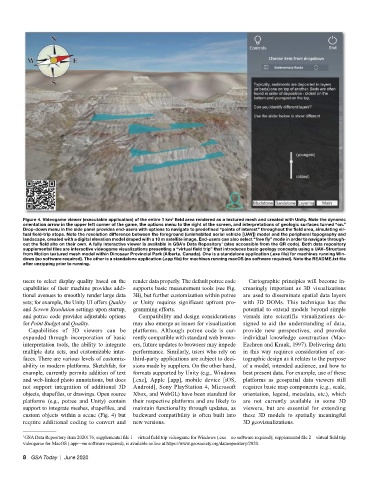
Figure 4. Videogame viewer (executable application) of the entire 1 km field area rendered as a textured mesh and created with Unity. Note the dynamic
orientation arrow in the upper left corner of the game, the options menu to the right of the screen, and interpretations of geologic surfaces turned “on.”
Drop-down menu in the side panel provides end-users with options to navigate to predefined “points of interest” throughout the field area, simulating vir-
tual field-trip stops. Note the resolution difference between the foreground (uninhabited aerial vehicle [UAV]) model and the peripheral topography and
landscape, created with a digital elevation model draped with a 10 m satellite image. End-users can also select “free fly” mode in order to navigate through-
1
out the field site on their own. A fully interactive viewer is available in GSA’s Data Repository (also accessible from the QR code). Both data repository
supplemental files are interactive videogame visualizations presenting a “virtual field trip” that introduces basic geology concepts using a UAV–Structure
from Motion textured mesh model within Dinosaur Provincial Park (Alberta, Canada). One is a standalone application (.exe file) for machines running Win-
dows (no software required). The other is a standalone application (.app file) for machines running macOS (no software required). Note the README.txt file
after unzipping prior to running.
users to select display quality based on the render data properly. The default potree code Cartographic principles will become in-
capabilities of their machine provides addi- supports basic measurement tools (see Fig. creasingly important as 3D visualizations
tional avenues to smoothly render large data 3B), but further customization within potree are used to disseminate spatial data layers
sets; for example, the Unity UI offers Quality or Unity requires significant upfront pro- with 3D DOMs. This technique has the
and Screen Resolution settings upon startup, gramming efforts. potential to extend models beyond simple
and potree code provides adjustable options Compatibility and design considerations visuals into scientific visualizations de-
for Point Budget and Quality. may also emerge as issues for visualization signed to aid the understanding of data,
Capabilities of 3D viewers can be platforms. Although potree code is cur- provide new perspectives, and provoke
expanded through incorporation of basic rently compatible with standard web brows- individual knowledge construction (Mac-
interpretation tools, the ability to integrate ers, future updates to browsers may impede Eachren and Kraak, 1997). Delivering data
multiple data sets, and customizable inter- performance. Similarly, users who rely on in this way requires consideration of car-
faces. There are various levels of customiz- third-party applications are subject to deci- tographic design as it relates to the purpose
ability in modern platforms. Sketchfab, for sions made by suppliers. On the other hand, of a model, intended audience, and how to
example, currently permits addition of text formats supported by Unity (e.g., Windows best present data. For example, use of these
and web-linked photo annotations, but does [.exe], Apple [.app], mobile device [iOS, platforms as geospatial data viewers still
not support integration of additional 3D Android], Sony PlayStation 4, Microsoft requires basic map components (e.g., scale,
objects, shapefiles, or drawings. Open source Xbox, and WebGL) have been standard for orientation, legend, metadata, etc.), which
platforms (e.g., potree and Unity) contain their respective platforms and are likely to are not currently available in some 3D
support to integrate meshes, shapefiles, and maintain functionality through updates, as viewers, but are essential for extending
custom objects within a scene (Fig. 4) but backward compatibility is often built into these 3D models to spatially meaningful
require additional coding to convert and new versions. 3D geovisualizations.
1 GSA Data Repository item 2020176, supplemental file 1—virtual field trip videogame for Windows (.exe—no software required); supplemental file 2—virtual field trip
videogame for MacOS (.app—no software required), is available online at https://www.geosociety.org/datarepository/2020.
8 GSA Today | June 2020