
Page 5 - i1052-5173-30-6
P. 5
N N N
E E E
accretion
paleo ow
paleo ow accretion channel-belt deposit
2
2 mm
channel-belt base oodplain mudstone channel-belt base
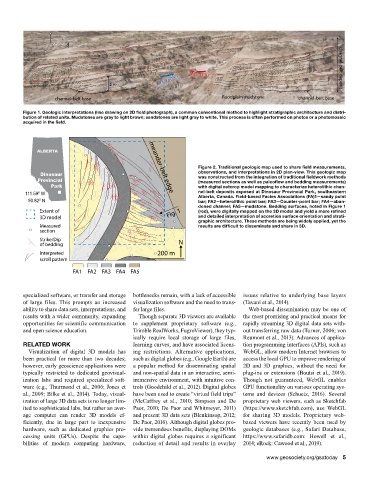
Figure 1. Geologic interpretations (line drawing on 2D field photograph), a common conventional method to highlight stratigraphic architecture and distri-
bution of related units. Mudstones are gray to light brown; sandstones are light gray to white. This process is often performed on photos or a photomosaic
acquired in the field.
ALBERTA
Figure 2. Traditional geologic map used to share field measurements,
Dinosaur observations, and interpretations in 2D plan-view. This geologic map
Provincial was constructed from the integration of traditional fieldwork methods
(measured sections as well as paleoflow and bedding measurements)
Park with digital outcrop model mapping to characterize heterolithic chan-
111.59º W nel-belt deposits exposed at Dinosaur Provincial Park, southeastern
meander-belt edge
Alberta, Canada. Field-based Facies Associations (FA)1—sandy point
50.82º N bar; FA2—heterolithic point bar; FA3—Counter-point bar; FA4—aban-
doned channel; FA5—mudstone. Bedding surfaces, noted in Figure 1
Extent of Fig. 1 (red), were digitally mapped on the 3D model and yield a more refined
3D model and detailed interpretation of accretion surface orientation and strati-
graphic architecture. These methods are being widely applied, yet the
Measured results are difficult to disseminate and share in 3D.
section
Strike/Dip
of bedding N
Interpreted 200 m
scroll pattern
FA1 FA2 FA3 FA4 FA5
specialized software, or transfer and storage bottlenecks remain, with a lack of accessible issues relative to underlying base layers
of large files. This prompts an increased visualization software and the need to trans- (Tavani et al., 2014).
ability to share data sets, interpretations, and fer large files. Web-based dissemination may be one of
results with a wider community, expanding Though separate 3D viewers are available the most promising and practical means for
opportunities for scientific communication to supplement proprietary software (e.g., rapidly streaming 3D digital data sets with-
and open science education. Trimble RealWorks, FugroViewer), they typ- out transferring raw data (Turner, 2006; von
ically require local storage of large files, Reumont et al., 2013). Advances of applica-
RELATED WORK learning curves, and have associated licens- tion programming interfaces (APIs), such as
Visualization of digital 3D models has ing restrictions. Alternative applications, WebGL, allow modern Internet browsers to
been practical for more than two decades; such as digital globes (e.g., Google Earth) are access the local GPU to improve rendering of
however, early geoscience applications were a popular method for disseminating spatial 2D and 3D graphics, without the need for
typically restricted to dedicated geovisual- and non-spatial data in an interactive, semi- plug-ins or extensions (Boutsi et al., 2019).
ization labs and required specialized soft- immersive environment, with intuitive con- Though not guaranteed, WebGL enables
ware (e.g., Thurmond et al., 2006; Jones et trols (Goodchild et al., 2012). Digital globes GPU functionality on various operating sys-
al., 2009; Bilke et al., 2014). Today, visual- have been used to create “virtual field trips” tems and devices (Schuetz, 2016). Several
ization of large 3D data sets is no longer lim- (McCaffrey et al., 2010; Simpson and De proprietary web viewers, such as Sketchfab
ited to sophisticated labs, but rather an aver- Paor, 2010; De Paor and Whitmeyer, 2011) (https://www.sketchfab.com), use WebGL
age computer can render 3D models ef- and present 3D data sets (Blenkinsop, 2012; for sharing 3D models. Proprietary web-
ficiently, due in large part to inexpensive De Paor, 2016). Although digital globes pro- based viewers have recently been used by
hardware, such as dedicated graphics pro- vide tremendous benefits, displaying DOMs geologic databases (e.g., Safari Database,
cessing units (GPUs). Despite the capa- within digital globes requires a significant https://www.safaridb.com: Howell et al.,
bilities of modern computing hardware, reduction of detail and results in overlay 2014; eRock: Cawood et al., 2019).
www.geosociety.org/gsatoday 5