
Page 7 - i1052-5173-30-6
P. 7
A
1
2 Dipping beds
These alternating sandstone
and siltstone beds are not
at (or horizontal).
They are actually dipping
towards the southwest
See #2 for more....
B
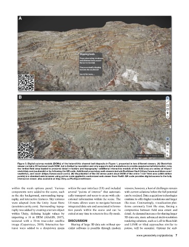
Figure 3. Digital outcrop models (DOMs) of the heterolithic channel-belt deposits in Figure 1, presented in two different viewers. (A) Sketchfab
viewer contains 3D textured mesh DOM, but is limited by resolution and only supports text annotations to provide supplemental information; note
the limited field area loaded to preserve detail in texture and topography—additional interactive models of the field area are online at https://
sketchfab.com/paulnesbit or by following the QR code. Additional proprietary web viewers include Euclidean Vault (https://www.euclideon.com/
vaultinfo/), and voxxlr (https://www.voxxlr.com/). (B) Visualization of the 3D dense point cloud DOM of the entire 1 km field area (>805 million
2
points) in a standard web browser using potree code applied in customized web viewer from Pix4D. QR code provides digital access to the fully
interactive viewer, also available at http://tiny.cc/Pix4DpotreeViewer.
within the mesh options panel. Various within the user interface (UI) and included viewers; however, a host of challenges remain
components were added to the scene, such several “points of interest” that automati- with current solutions before the full potential
as the sky background, surrounding topog- cally transport end-users to areas with edu- can be realized. Data acquisition technologies
raphy, and interactive features. Sky textures cational information within the scene. The continue to offer higher resolutions and larger
were adapted from the Unity Asset Store UI menu allows users to navigate between file sizes. Contrastingly, visualization plat-
(assetstore.unity.com). Surrounding topog- integrated data sets and associated informa- forms commonly limit file sizes, forcing a
raphy was added by creating a terrain object tion panels within the scene and can be compromise between field area extent and
within Unity, defining height values by exited at any time to return to free fly mode. detail. As demand increases for sharing larger
importing a 10 m DEM (AltaLIS, 2017), 3D data sets, more advanced multi-resolution
textured with a 10-m true-color satellite DISCUSSION rendering solutions, such as LoD in Sketchfab
image (Copernicus, 2018). Interactive fea- Sharing of large 3D data sets without spe- and LIME or tiled approaches similar to
tures were added to a dropdown menu cialist software is possible through modern potree, will be essential. Options for end-
www.geosociety.org/gsatoday 7