
Complex subsurface of Mars imaged by Chinese rover Zhurong
In this article
Complex subsurface of Mars imaged by Chinese rover Zhurong
Boulder, Colo., USA: Ground-penetrating radar from China’s Martian rover Zhurong reveals shallow impact craters and other geologic structures in the top five meters of the red planet’s surface. The images of the Martian subsurface are presented in a paper published in Geology Thursday.
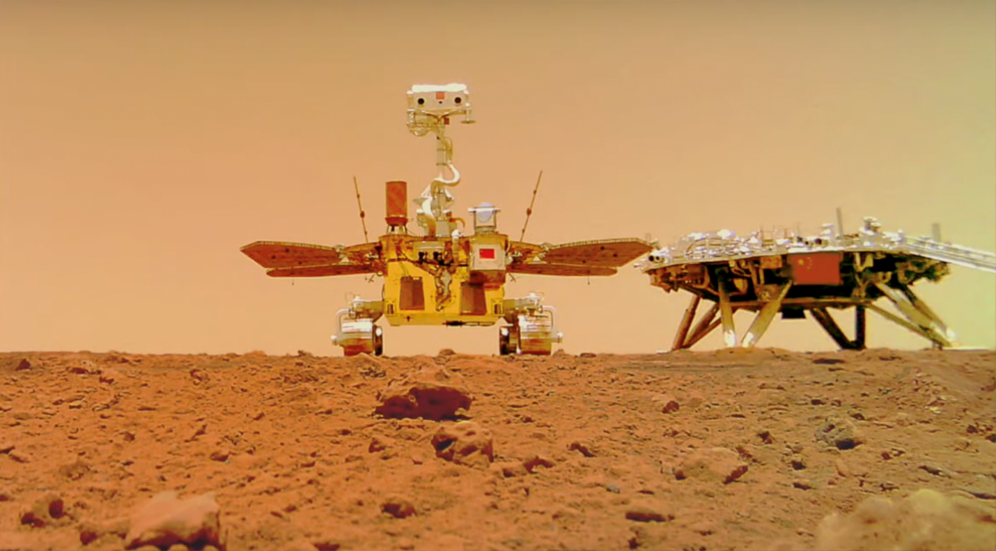
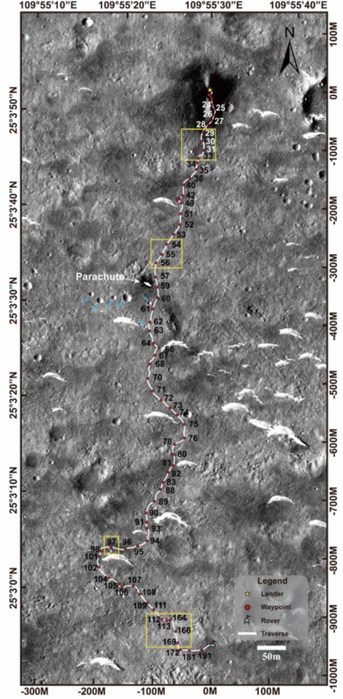
The Zhurong rover was sent to Mars as part of China’s Tianwen-1 mission. Launched in July 2020, the rover landed on the surface on 15 May 2021. The rover was sent to a large plain in the northern hemisphere of Mars named Utopia Planitia, near the boundary between the lowlands where it landed and highlands to the south. The region was chosen because it’s near suspected ancient shorelines and other interesting surface features, where the rover could look for evidence of water or ice. A large body of underground ice was identified in a nearby part of Utopia Planitia in 2016 by radar from NASA’s Mars Reconnaissance Orbiter. After landing, the Zhurong rover traveled about 1.9 km south, taking pictures of rocks, sand dunes, and impact craters, and collecting ground-penetrating radar data along the way.
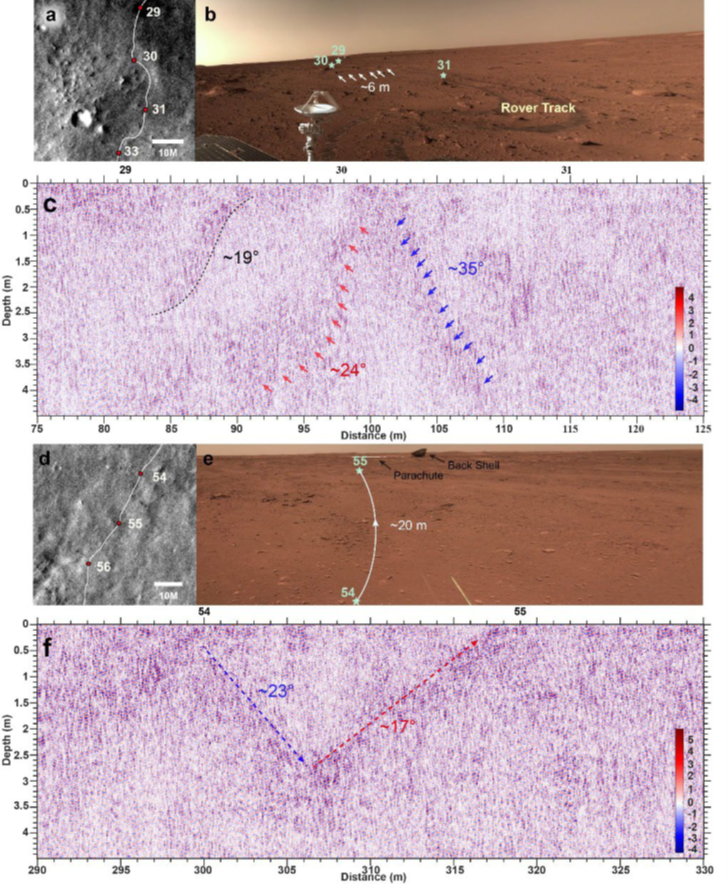
Ground-penetrating radar detects features underground by sending electromagnetic pulses into the ground that are reflected back by any subsurface structures it passes over. The Zhurong rover uses two radar frequencies—a lower frequency that reaches deeper (~80 meters) with less detail, and a higher frequency used for the latest study, which shows more detailed features but only reaches ~4.5 meters down. Researchers hope that imaging the subsurface of Mars will help to shed light on the planet’s geologic history, previous climate conditions, and any water or ice the planet may host now or in the past.
The researchers saw several curving and dipping underground structures in the Martian soil that they identify as buried impact craters, as well as other sloping features with less certain origins. They did not see any evidence of water or ice in the top five meters of soil. Radar images of the deeper structures revealed layers of sediment left by episodes of flooding and deposition in the past, but also found no evidence of water in the present day. This does not rule out the possibility of water deeper than the eighty meters imaged with the radar.
In the new paper, the researchers contrast the data from Mars with ground-penetrating radar previously collected from the moon, which shows a much different shallow subsurface structure. Where the shallow Martian surface contains several distinct features that show up in the radar, the top 10 meters of the moon has fine layers but no evidence of other structures like impact crater walls, despite also being subjected to meteorite bombardment. The walls of impact craters are, however, observed at greater depths on the moon, buried beneath the 10-meter-thick layer of fine debris.
The difference may be in the atmosphere—while Mars’ atmosphere is a meager 1% of the volume of Earth’s, the moon has virtually no atmosphere. With essentially no atmospheric protection, the moon’s surface is bombarded by more of the smallest micrometeorites that rework the surface, eroding smaller-scale features and leaving behind fine layers of ejecta. By contrast, the surface of Mars is not being subjected to as many micrometeorite impacts because these smaller objects burn up in the atmosphere. In the regions imaged by Zhurong, burial by wind-blown sediment may have also protected the impact craters from erosion. One of the craters imaged had its rim exposed at the surface, but the other crater was buried.
Yi Xu, the lead author on the study, explains, “We found a lot of dunes on the surface at the landing site, so maybe this crater was quickly buried by the sand and then this cover reduced space weathering, so we can see the full shape of these craters walls.”
FEATURED ARTICLE
Martian soil as revealed by the ground-penetrating-radar at the Tianwen-1 landing site
Ruonan Chen; Ling Zhang; Yi Xu; Renrui Liu; Roberto Bugiolacchi; Xiaoping Zhang; Lu Chen; Zhaofa Zeng; Cai Liu
Contact: Yi Xu, Macau University of Science and Technology, yixu@must.edu.mo
https://pubs.geoscienceworld.org/gsa/geology/article-abstract/doi/10.1130/G50632.1/620359/Martian-soil-as-revealed-by-ground-penetrating
GEOLOGY articles are online at https://geology.geoscienceworld.org/content/early/recent.
Representatives of the media may obtain complimentary articles by contacting Kea Giles at the e-mail address above. Please discuss articles of interest with the authors before publishing stories on their work, and please make reference to GEOLOGY in articles published. Non-media requests for articles may be directed to GSA Sales and Service, gsaservice@geosociety.org.
# # #
Contact Information
Contributed by Laura Fattaruso
Contact:
Kea Giles
+1-303-357-1057
kgiles@geosociety.org
