
Page 5 - i1052-5173-32-6
P. 5
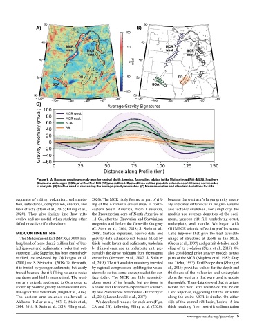
Figure 1. (A) Bouguer gravity anomaly map for central North America. Anomalies related to the Midcontinent Rift (MCR), Southern
                  Oklahoma Aulacogen (SOA), and Reelfoot Rift (RR) are outlined. Dashed lines outline possible extensions of rift arms not included
                  in analysis. (B) Profiles used in calculating the average gravity anomalies. (C) Mean anomalies and standard deviations for rifts.


         sequence of rifting, volcanism, sedimenta-  2020). The MCR likely formed as part of rift-  because the west arm’s larger gravity anom-
         tion, subsidence, compression, erosion, and   ing of the Amazonia craton (now in north-  aly indicates differences in magma volume
         later effects (Stein et al., 2015; Elling et al.,   eastern South America) from Laurentia,   and tectonic evolution. For simplicity, the
         2020). They give  insight  into how rifts   the Precambrian core of North America at   models use average densities of the sedi-
         evolve and are useful when studying other   1.1 Ga, after the Elzeverian and Shawinigan   ment, igneous rift fill, underlying crust,
         failed or active rifts elsewhere.   orogenies and before the Grenville Orogeny   underplate, and mantle. We began with
                                             (C. Stein et al., 2014, 2018; S. Stein et al.,   GLIMPCE seismic reflection profiles across
         MIDCONTINENT RIFT                   2018). Surface exposures, seismic data, and   Lake Superior that give the best available
          The Midcontinent Rift (MCR), a 3000-km-  gravity data delineate rift basins filled by   image of structure at depth in the MCR
         long band of more than 2 million km  of bur-  thick basalt layers and sediments, underlain   (Green et al., 1989) and permit detailed mod-
                                    3
         ied igneous and sedimentary rocks that out-  by thinned crust and an underplate unit, pre-  eling of its evolution (Stein et al., 2015). We
         crop near Lake Superior, has been extensively   sumably the dense residuum from the magma   also considered prior gravity models across
         studied, as reviewed by Ojakangas et al.   extraction (Vervoort et al., 2007; S. Stein et   parts of the MCR (Mayhew et al., 1982; Shay
         (2001) and S. Stein et al. (2018). To the south,   al., 2018). The rift was later massively inverted   and Trehu, 1993). EarthScope data (Zhang et
         it is buried by younger sediments, but easily   by regional compression, uplifting the volca-  al., 2016) provided values for the depth and
         traced because the rift-filling volcanic rocks   nic rocks so that some are exposed at the sur-  thickness of the volcanics and underplate
         are dense and highly magnetized. The west-  face  today.  The  MCR  has  little  seismicity   along the west arm that were used to update
         ern arm extends southward to Oklahoma, as   along most of its length, but portions in   the models. These data showed that structure
         shown by positive gravity anomalies and sim-  Kansas and Oklahoma experienced seismic-  below the west arm resembles that below
         ilar-age diffuse volcanism (Bright et al., 2014).   ity and Phanerozoic deformation (Burberry et   Lake Superior, suggesting that the structure
         The eastern arm extends southward to   al., 2015; Levandowski et al., 2017).  along the entire MCR is similar. On either
         Alabama (Keller et al., 1983; C. Stein et al.,   We developed models for each arm (Figs.   side of the central rift basin, basins ~5 km
         2014, 2018; S. Stein et al., 2018; Elling et al.,   2A and 2B), following Elling et al. (2020),   thick resulting from post-rift sedimentation

                                                                                          www.geosociety.org/gsatoday  5