
Page 5 - i1052-5173-27-3-4
P. 5
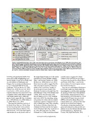
A. 124°W                   JKLe                 123°45'W           123°30'W                                B.

  Leech River Fault                                       Sooke Lake dam  Wrangellia     48°30'N           Mylonitic fabric

Sombrio Pt.                Hydroelectric
                           plant dams
N   Juan de  Fuca                                   EMe Parts C&D              Victoria
    10 km                       EOCa
                   Strait                                                 DGrDeMenFe; ,B2a0r1ri5e and                        75 N

C.           JKLe             Site B                                45    Site C     60                                      Qa.
                           90                                                                                                Colwood Delta
    30         75          N                    50        EMe                                          71  45

    Site A 25                                                             52
                                                                                      30 20
    2 km

D.

   Site A                     Site B                                      Site C
                           N
   2 km

    Quat. deposits, undi . (Qa)                           Mapped fault Ice ow                              South-facing scarp or bench
                                                          Observed           lidar-derived                 Linear swale or sag
    Eoc.-Olig. Carmanah Grp. (EOCa)                       Inferred           striae                        North-facing scarp or bench
    Eoc. Metchosin Fm. (EMe)
    Jur.-Cret. Leech River Complex and                    Covered Foliation                                Probable scarp
    Pandora Peak Unit (JKLe)
    Wrangellia terrane, undi .                            Topographic scarp

Figure 2. (A) Simplified geologic map of the Leech River fault and surroundings (after Massey et al., 2005). Red lines denote topo-
graphic scarps, pressure ridges, topographic benches, and linear swales and sags identified in this study. See geological legend at
base of figure. DDMF—Darrington–Devil’s Mountain fault. (B) Mylonitic fabrics within the Leech River Complex near its contact with
the Metchosin Fm. (C) Map showing trace of identified features relative to bedrock (Massey et al., 2005), surficial deposits (Blyth and
Rutter, 1993), and local ice flow indicators (blue arrows, this study). Foliation measurements from this study are shown in bold and
those from Muller (1983) are shown in italics. Foliation data outlined in white are at the lithologic contact (this study). (D) Fault traces
as in part C, colored according to facing direction and feature type, draped on LiDAR hillshade image.

trenching, and geophysical studies have             the seismic hazard it may pose to the nearby           activity is also recognized 10–20 km
proven successful at highlighting a net-            population of Victoria, British Columbia               offshore of the Leech River fault along a
work of oblique reverse forearc faults, both        (Figs. 1 and 2A) (see Cassidy et al., 2000;            structure in the Juan de Fuca Strait (Barrie
on- and offshore of Washington and                  Mosher et al., 2000; Balfour et al., 2011).            and Greene, 2015) (Figs. 1 and 2A), but
Oregon, that can produce earthquakes up             Several previous authors suggest that this             direct evidence for recent rupture onshore
to 7.5 in magnitude (McCaffrey and                  fault, which places Jurassic-Cretaceous                has remained ambiguous.
Goldfinger, 1995; ten Brink et al., 2006;           schists of the Leech River Complex to
Blakely et al., 2014; Sherrod et al., 2016).        the north against Eocene basalts of the                  Here, we use a combination of techniques
In particular, LiDAR, seismic, and aero-            Metchosin Formation to the south (Fig. 2A)             to delineate Quaternary fault-related fea-
magnetic data have been paramount in the            (Fairchild and Cowan, 1982; Rusmore and                tures along the Leech River fault, including
recognition of the Seattle fault as a signifi-      Cowan, 1985), was last active in the                   (1) mapping of fault scarps from hillshade
cant seismic hazard source within the               Eocene (MacLeod et al., 1977; Johnston                 and local slope images generated from a
greater Seattle region (SF, Fig. 1) (Johnson        and Acton, 2003). Yet, trenching, coring,              high resolution (~2 m horizontal by ~10 cm
et al., 1999; Blakely et al., 2002; Kelsey et       and geophysical studies indicate multiple              vertical) LiDAR digital elevation model
al., 2008; Nelson et al., 2014).                    Quaternary ruptures of adjacent fault sys-             (DEM) collected by Natural Resources
                                                    tems in Washington state, USA, including               Canada (James et al., 2010); (2) first-order
  The potential Quaternary activity of              the Southern Whidbey Island fault, the                 bedrock and surficial field mapping;
the Leech River fault, an ~60-km-long               Utsalady Point fault, and the Darrington–              (3) collection of detailed structural and
terrane-bounding fault in the southern              Devil’s Mountain fault (Fig. 1) (Johnson et            geomorphic data at key sites; and (4) com-
Vancouver Island forearc (Muller, 1977;             al., 1996, 2001; Sherrod et al., 2008;                 pilation of our observations with data from
MacLeod et al., 1977), has drawn signifi-           Personius et al., 2014). Quaternary seismic            previous studies (e.g., Fairchild and
cant attention in recent years because of                                                                  Cowan, 1982; Blyth and Rutter, 1993;

                                                    www.geosociety.org/gsatoday                                                                          5