
Page 6 - i1052-5173-27-3-4
P. 6
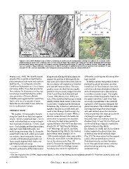
BHeight (m)  P1 VS = 5.7 ± 1.7 m
                                                      10 20 30
A                                                  N colluvial surface                       VS
                  downhill

Colluvial  P1                                                              channel              P2
  apron
                                               P2               N                            VS = 3.2 ± 1.2 m S
                                                                -40 -20 0 20 40
                                                                              Distance (m)

                                                      C                                             View to N
                                                              Channel                        Channel
                                                               margin                        bottom

           uphill

100 m      Bedrock                                                                               Scarp
                                                                                                  face

Figure 3. (A) LiDAR hillshade map of Site A, showing an uphill (south) facing scarp cutting the surface of a steeply north-
sloping colluvial apron and channels. Red arrows point to steep face. Black and white arrows show apparent left and right
(respectively) lateral separations of channel margins. Example profile lines (P1 and P2) locations shown. Additional profile
lines are shown in Figure DR2 (see text footnote 1). (B) An example of LiDAR-derived elevation profiles from interfluve P1 and
channel P2. VS—vertical separation. (C) Field photo showing tectonic scarp in a channel at site C.

Massey et al., 2005). We identify several      along steeply dipping foliation planes, we    differential erosion across this strong litho-
strands of the Leech River fault that dis-     mapped the position of lithologically dis-    logic contrast.
place post-glacial sediments and record at     tinct units and collected structural data on
least two MW >6 earthquakes since the          the occurrence and orientation of foliation     To further exclude topographic features
Cordilleran deglaciation ca. 15 ka (Clague     and fault deformation fabrics. The topo-      produced by glacial processes, we deter-
and James, 2002). These data provide the       graphic scarps we identified are roughly      mined local ice flow directions from bed-
first evidence for Quaternary surface rup-     parallel to the previously mapped location    rock striae and streamlined glacial deposits
ture along a crustal fault that lies within    of the Leech River fault (Fairchild and       and collected geomorphic data designed
close proximity of Victoria, British           Cowan, 1982; Massey et al., 2005), but        to confirm a tectonic origin. The roughly
Columbia, and suggest that the Leech River     none of the identified fault scarps coincide  east-west–oriented topographic features on
fault is only one of a network of active       exactly with the fault contact between the    the eastern half of the Leech River fault
faults that accommodate forearc deforma-       Leech River Complex and the Metchosin         are nearly perpendicular to the southerly
tion in southwestern Canada.                   Formation (Fig. 2). Instead, individual top-  regional ice flow direction during the last
                                               ographic features occur both north and        glacial maximum. The LiDAR data delin-
OBSERVATIONS                                   south of the lithologic fault boundary by     eate large (km-long) drumlinoid ridges
                                               as much as hundreds of meters. Where a        with well-defined apices that are distinc-
  We mapped >60 topographic features           discrete contact between the basalt and       tively streamlined with steep up-ice (north-
along the Leech River fault that together      schist units is exposed at two locations      ern) margins and upper surfaces
extend >60 km in length and span ~1 km in      in the area, the fault strikes parallel to    that gently slope in a southerly, down-ice
width. Individual features range in length     regional foliation (300–310°) but dips more   direction (Figs. 2C and 2D). Our field work
from hundreds of meters to >2.5 km, reach      steeply (70–90° NE) than the foliation        confirms that these ridges are mantled by
up to ~5 m in height, and form linear ridges,  (~45° NE) (Figs. 2B and 2C, and GSA           glacial sediments (Fig. DR1E
sags, and scarps with both north- and          Data Repository1 Fig. DR1A). The western-     [see footnote 1]). South-directed ice flow is
south-facing directions (Fig. 2). Along the    most of these sites contains a 10- to         further supported by glacial striae data
eastern half of the fault, where we focused    >200-m-wide mylonitic shear zone within       on bedrock near the drumlinoid ridges
our analysis, these topographic features       both units, but exhibits no brittle deforma-  (Fig. 2C). The observation that the mapped
coincide with displaced geomorphic sur-        tion at the outcrop scale (Figs. 2B           scarps strike perpendicular to the ice
faces, steeply dipping brittle faults, and     and 2C). Because the mapped features do       flow direction rules out their formation
uphill-facing bedrock scarps.                  not coincide with the lithologic terrane      by ice flow–parallel processes, including
                                               boundary, they cannot be explained by         glacial scouring, grooving, molding,
  In order to exclude topographic features                                                   and streamlining.
that were produced by differential erosion

1 GSA Data Repository Item 2017046, supplementary figures, is online at http://www.geosociety.org/datarepository/2017/. If you have questions, please email
gsatoday@geosociety.org.

6 GSA Today | March–April 2017