
Page 6 - i052-5173-30-9-compressed
P. 6
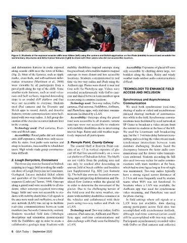
Figure 2. Students at the exposed seaside cliffs near Kilkee (left) using the camera and Skitch application on the iPads (middle) to record and annotate the
         sedimentary structures and deformation features (right) to share with their peers who did not access this location.

         and deformation features in rocks exposed   mobility disabilities mapped outcrops along   Accessibility: Exposures of glacial till were
         along seaside cliffs near the town of Kilkee   the gravel road, while mobile students mapped   only accessible by climbing down large, wet
         (Fig. 2). Most of the features, such as ripple   outcrops in more distant and less accessible   boulders along the shore. Rainy and windy
         marks, cross-beds, and soft-sediment defor-  locations. Students communicated in real   weather made outdoor audio communications
         mation structures (Martinsen et al., 2008)   time via two-way radios and iPads using the   difficult.
         were viewable by all participants from a   AirBeam app. Photos were shared in near real
         paved path along the top of the cliffs. Some   time with the PhotoSync app. Videos were   TECHNOLOGY TO ENHANCE FIELD
         smaller-scale features, such as sand volca-  recorded asynchronously with GoPro cam-  ACCESS AND INCLUSION
         noes and fault surfaces, required descending   eras and shared between team members upon
         steps to an eroded cliff platform and thus   reconvening in common locations.  Synchronous and Asynchronous
         were  not  accessible  to  everyone.  Students   Technology used: Two-way radios, GoPro   Communication
         used iPad cameras and the Evernote and   cameras, iPad cameras, FieldMove, AirBeam,   We used both synchronous (real-time
         Skitch apps to record, sketch, and describe   and PhotoSync apps, with real-time commu-  sharing of audio or video) and asynchronous
         features; remote communications were facil-  nications facilitated by a LAN.  (delayed sharing) methods of communica-
         itated with two-way radios. A full group dis-  Accessibility: Outcrops along the gravel   tion while in the field. Synchronous commu-
         cussion of the exercise occurred indoors later   road were accessible to all students; remote   nications were facilitated by a cell network at
         in the evening.                     outcrops were not accessible to students   SP Crater to broadcast a video stream from
          Technology used: iPad cameras, Ever-  with mobility disabilities due to intervening   the summit to students at the base of the hill.
         note and Skitch apps.               uneven bogs. Rainy and cold weather nega-  We used the Livestream web broadcasting
          Accessibility: Paved paths did not extend   tively impacted all participants.  app, but the 1–2-minute delay between trans-
         onto cliff exposures, which were only acces-                           mitting and receiving the video stream made
         sible by stairs. Foot paths were narrow and   3. Renvyle Point, County Galway  synchronous interactions between team
         steep in locations, inaccessible to wheelchair   The coastal bluff at Renvyle Point con-  members challenging. Students found the
         users. High winds made group communica-  sists of an ~15 m vertical exposure of gla-  discrepancy between the faster audio com-
         tions difficult.                    cial till that lies unconformably on a wave   munications and the slower video transmis-
                                             cut platform of Dalradian Schist. The bluffs   sions awkward. Students ascending the hill
         2. Lough Derryclare, Connemara      are not visible from the parking area and   also used two-way radios for audio commu-
          This three-day exercise focused on bedrock   can only be reached after descending an   nications with team members at the base,
         mapping in a boggy field area along the south-  uneven field of beach cobbles and boulders   which had no time lag as long as line-of-sight
         ern shore of Lough Derryclare in Connemara.   (see Supplemental Fig. SD2 [see footnote   was maintained. Two-way radios typically
         Geological features included folded schists   1]). The half-day exercise focused on exam-  have a strong signal across distances of
         and quartzites of the Connemara Dalradian   ining and interpreting deformation and flu-  2–3 km and were frequently used by student
         sequence (Leake and Tanner, 1994). Outcrops   idized flow features within the glacial till   teams when  WiFi was not functional. In
         along a gravel road were accessible to all stu-  in order to determine the movement of the   locations where a LAN was available, the
         dents; other outcrops required traversing   glacier. Due to the challenging terrain of   AirBeam app was used for synchronous
         boggy fields and were not accessible to stu-  the field area and the rainy weather, stu-  video streaming, and PhotoSync was used
         dents with mobility disabilities. Cell signals in   dents with mobility disabilities remained in   for photo sharing.
         the area were weak and ineffective, so a local   the vehicles and collaborated with their   In field settings where cell signals or a
         area network (LAN) was set up to facilitate   peers using two-way radios and iPads via     LAN were not available, data sharing
         real-time communications between team   a LAN.                         among  participants across field  sites was
         members (see Network Connectivity section).   Technology used: Two-way radios, GoPro   accomplished with asynchronous methods,
         Students recorded field data (lithologic   cameras, iPad cameras, AirBeam and Photo-  although real-time communication could
         descriptions and orientation measurements)   Sync  apps;  real-time  communications  and   still be accomplished with two-way radios.
         with the FieldMove app in order to create a   data exchange with iPads were facilitated by   Participants asynchronously recorded video
         collaborative geologic map. Students with   a LAN.                     with GoPro or iPad cameras and collected

         6  GSA Today  |  September 2020