
Page 5 - i052-5173-30-9-compressed
P. 5
(during the project exercises) and field trip Accessibility: Equitable access to the site; summit from two approaches. One trail
participants (during the dissemination field paved and packed dirt paths available for all wrapped around the mountain and ascended
trips) across sites that were easy to access to explore the park, but cliff outcrops were the back side, and the other took a direct path
(roads, well-groomed paths, etc.) and loca- only viewable from a distance (~500 m). up the front of the mountain. Students used
tions with more challenging terrains. Field two-way radios to communicate during the
environments ranged from arid, dry condi- 2. The Grand Canyon hike. However, students who hiked around
tions (Arizona, PEFO) to colder and wetter This exercise focused on the Trail of Time the back of the mountain lost line-of-sight
conditions (Ireland, Mount St. Helens). (ToT), a 1.6 km paved trail along the south rim and radio contact with their partners at the
of the Grand Canyon, with tactile exhibits that vehicles, while those who took the front path
EXAMPLE FIELD TRIPS document two billion years of regional geo- to the top maintained line-of-sight and com-
logic history (Karlstrom et al., 2008). Students munications with the group at the base. Once
Arizona Field Sites, Year 1 worked in teams across ability levels to visit at the top of the mountain, all students were
We visited field locations in central Ari- sites along the ToT that displayed rock sam- able to communicate with their partners at
zona in May 2015, including Slide Rock ples obtained from deep within the canyon, the base using two-way radios as well as the
State Park in Oak Creek Canyon, The Trail which illustrate the classic stratigraphy of the Livestream app for real-time video broad-
of Time on the south rim of the Grand Can- Grand Canyon. Student teams used the Strat- casts of the summit views.
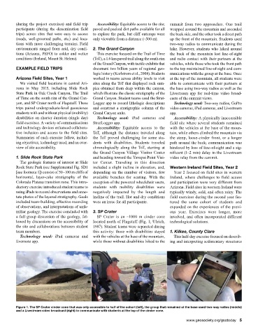
yon, and SP Crater north of Flagstaff. These Logger app to record lithologic descriptions Technology used: Two-way radios, GoPro
trips paired undergraduate-level geoscience and construct a stratigraphic column of the video cameras, iPad cameras, and Livestream
students with and without physical (mobility) Grand Canyon units. app.
disabilities on shorter duration (single day) Technology used: iPad cameras and Accessibility: A physically inaccessible
field exercises. A variety of communications StratLogger app. field site where several students remained
and technology devices enhanced collabora- Accessibility: Equitable access to the with the vehicles at the base of the moun-
tive inclusion and access to the field sites. ToT, although the distance traveled along tain, while others climbed the mountain via
Summaries of each exercise follow, includ- the ToT proved challenging for some stu- the steep, loose-cinder front, or a longer
ing objectives, technology used, and an over- dents with disabilities. Students traveled path around the back; communication was
view of site accessibility. chronologically along the ToT, starting at hindered by loss of line-of-sight and a sig-
the Grand Canyon Village Visitor Center nificant (1–2 min) delay in the Livestream
1. Slide Rock State Park and heading toward the Yavapai Point Visi- video relay from the summit.
The geologic features of interest at Slide tor Center. Traveling in this direction
Rock State Park (see Supplemental Fig. SD1 included a slight incline in elevation, and, Western Ireland Field Sites, Year 2
[see footnote 1]) consist of 50–100 m cliffs of depending on the number of visitors, few Year 2 focused on field sites in western
horizontal, layer-cake stratigraphy of the available benches for seating. With the Ireland, where challenges to field access
Colorado Plateau transition zone. This intro- exception of the powered wheelchair users, and participation were very different from
ductory exercise introduced student teams to students with mobility disabilities were Arizona. Field sites in western Ireland were
using iPads to record observations and anno- negatively impacted by the length and typically windy, cold, and often rainy. The
tate photos of the layered stratigraphy. Goals incline of the trail. Hot and dry conditions field exercises during the second year fea-
included team-building, effective recording were an issue for all participants. tured the same cohort of students and
of observations, and interpretations of unfa- expanded on the experiences of the previ-
miliar geology. The exercise concluded with 3. SP Crater ous year. Exercises were longer, more
a full group discussion of the geology, fol- SP Crater is an ~1000 m cinder cone involved, and often incorporated different
lowed by discussions on the accessibility of located north of Flagstaff (Fig. 1; Ulrich, technological solutions.
the site and collaborations between student 1987). Student teams were separated during
team members. this activity: those with disabilities stayed 1. Kilkee, County Clare
Technology used: iPad cameras and with the vehicles at the base of the mountain, This half-day exercise focused on describ-
Evernote app. while those without disabilities hiked to the ing and interpreting sedimentary structures
Figure 1. The SP Crater cinder cone that was only accessible to half of the cohort (left), the group that remained at the base used two-way radios (middle)
and a Livestream video broadcast (right) to communicate with students at the top of the cinder cone.
www.geosociety.org/gsatoday 5