
Page 8 - i1052-5173-32-7
P. 8
There is no evidence via gamma-ray been deposited in a maximum water depth of
correlations or biostratigraphy that the 120 m (Petty, 2019a) based on Scallion clino-
Bakken black shales transition landward form thickness and compaction assump-
into any other lithology, an observation tions. Using similar assumptions for the
acknowledged by many deep-water advo- lower Virden, the basinal facies is estimated
cates (Caplan and Bustin, 1998; Smith and to have been deposited in a maximum water
Bustin, 2000; Egenhoff and Fishman, 2013). depth of 140 m.
The intra-shale, onlap stratal geometry, and The most significant advancement in the
gradual landward thinning of the Lower understanding of the lower Virden regional
Member black shale (Fig. 4) precludes the stratigraphy within the Williston basin was
erosional-remnant interpretation for the the recognition and regional mapping of
Lower Member because the long-distance the lower Lodgepole clinoform geometry
correlation of intra-shale gamma-ray char- (Grover, 1996). The lower Virden clinoform
acter indicates minimal intra-shale erosion is interpreted to represent shelf, to slope, to
within the Lower Member. The black shale basinal depositional environments, and the
of the Upper Member is interpreted to have corresponding facies are broadly referred to
undergone minimal truncation in the south- as the shelf facies, slope facies, and basinal
ern basin area based on the presence of uni- facies (Figs. 6 and 7). The clinoform is
form, landward stratal thinning (Fig. 3) and defined by a thin (<15 m), landward shelf
the absence of mappable truncation features. facies that transitions seaward into a thick
Large intra-Bakken sea-level changes, (maximum 80 m) slope facies that transi-
possibly greater than 200 m, have been tions farther seaward into a thin (<10 m)
inferred (Smith and Bustin, 1995, 1996, basinal facies.
2000; Caplan and Bustin, 2001; Hart and Beyond the clinoform geometry, the main
Hofmann, 2020) based on the assumption defining stratigraphic characteristics for the
that upper Member and lower Member black lower Virden system are (1) the presence of a
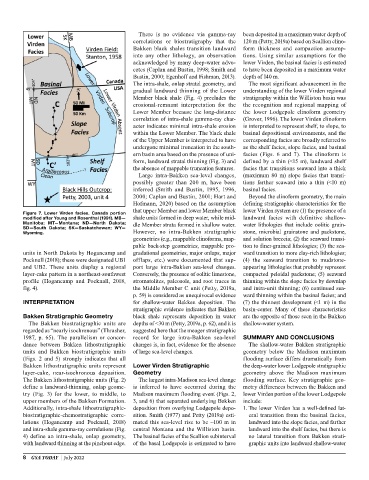
Figure 7. Lower Virden facies. Canada portion
modified after Young and Rosenthal (1991). MB— shale units formed in deep water, while mid- landward facies with definitive shallow-
Manitoba; MT—Montana; ND—North Dakota; dle Member strata formed in shallow water. water lithologies that include oolitic grain-
SD—South Dakota; SK—Saskatchewan; WY—
Wyoming. However, no intra-Bakken stratigraphic stone, microbial grainstone and packstone,
geometries (e.g., mappable clinoforms, map- and solution breccia; (2) the seaward transi-
pable back-step geometries, mappable pro- tion to finer-grained lithologies; (3) the sea-
units in North Dakota by Hogancamp and gradational geometries, major onlaps, major ward transition to more clay-rich lithologies;
Pocknall (2018); these were designated UB1 offlaps, etc.) were documented that sup- (4) the seaward transition to mudstone-
and UB2. These units display a regional port large intra-Bakken sea-level changes. appearing lithologies that probably represent
layer-cake pattern in a northeast-southwest Conversely, the presence of oolitic limestone, compacted peloidal packstone; (5) seaward
profile (Hogancamp and Pocknall, 2018, stromatolites, paleosols, and root traces in thinning within the slope facies by downlap
fig. 4). the Middle Member C unit (Petty, 2019a, and intra-unit thinning; (6) continued sea-
p. 59) is considered as unequivocal evidence ward thinning within the basinal facies; and
INTERPRETATION for shallow-water Bakken deposition. The (7) the thinnest development (<1 m) in the
stratigraphic evidence indicates that Bakken basin-center. Many of these characteristics
Bakken Stratigraphic Geometry black shale represents deposition in water are the opposite of those seen in the Bakken
The Bakken biostratigraphic units are depths of <30 m (Petty, 2019a, p. 62), and it is shallow-water system.
regarded as “nearly isochronous” (Thrasher, suggested here that the meager stratigraphic
1987, p. 65). The parallelism or concor- record for large intra-Bakken sea-level SUMMARY AND CONCLUSIONS
dance between Bakken lithostratigraphic changes is, in fact, evidence for the absence The shallow-water Bakken stratigraphic
units and Bakken biostratigraphic units of large sea-level changes. geometry below the Madison maximum
(Figs. 2 and 5) strongly indicates that all flooding surface differs dramatically from
Bakken lithostratigraphic units represent Lower Virden Stratigraphic the deep-water lower Lodgepole stratigraphic
layer-cake, near-isochronous deposition. Geometry geometry above the Madison maximum
The Bakken lithostratigraphic units (Fig. 2) The largest intra-Madison sea-level change flooding surface. Key stratigraphic geo-
define a landward-thinning, onlap geome- is inferred to have occurred during the metry differences between the Bakken and
try (Fig. 3) for the lower, to middle, to Madison maximum flooding event (Figs. 2, lower Virden portion of the lower Lodgepole
upper members of the Bakken Formation. 3, and 6) that separated underlying Bakken include:
Additionally, intra-shale lithostratigraphic- deposition from overlying Lodgepole depo- 1. The lower Virden has a well-defined lat-
biostratigraphic-chemostratigraphic corre- sition. Smith (1977) and Petty (2019a) esti- eral transition from the basinal facies,
lations (Hogancamp and Pocknall, 2018) mated this sea-level rise to be ~100 m in landward into the slope facies, and farther
and intra-shale gamma-ray correlations (Fig. central Montana and the Williston basin. landward into the shelf facies, but there is
4) define an intra-shale, onlap geometry, The basinal facies of the Scallion subinterval no lateral transition from Bakken strati-
with landward thinning at the pinchout edge. of the basal Lodgepole is estimated to have graphic units into landward shallow-water
8 GSA TODAY | July 2022