
Page 7 - i1052-5173-29-3-4
P. 7
1 km
Tracer injection GeoB00-483
N20°E Hole 3.4
Hole
380 U1362A U1362B
Hole
Hole U1301A 1026B
400 Pillow basalt Hole U1301B Hole U1362B U1362A Seafloor
1027B Seafloor = U1301B 1026B 1027C 3.6
2,600 m
420
Massive basalt
440 Depth (mbsl) Sediment 3.8
Depth (mbsf) 460 Basalt top 3.5 4.0 Two-way travel time (s)
480
500 Tracer 3.7
Dominant fluid flow direction transport 4.2
520 Basaltic ocean crust
Tracer 3.9 Two-way travel time (s)
540 detection 4.1 4.4
560 Basalt top
Basalt flow 0 1 km 4.3 4.6
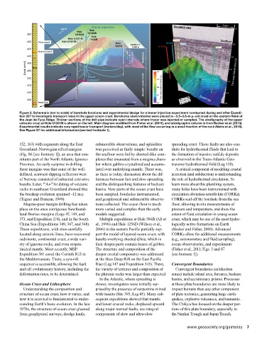
Figure 3. Schematic (not to scale) of borehole locations and experimental design for a tracer injection experiment conducted during and after Expedi-
tion 327 to investigate transport rates in the upper ocean crust. Boreholes observatories were placed in ~3.5–3.6-m.y.-old crust on the eastern flank of
the Juan de Fuca Ridge. Thicker sections of the drill pipe indicate open intervals where tracer was injected or sampled. The stratigraphy of the upper
volcanic crust at Hole U1301B is shown on the left. Main diagram modified from Fisher et al. (2011), and stratigraphic column is from Becker et al. (2013).
Experimental results indicate very rapid tracer transport (meters/day), with most of the flow occurring in a small fraction of the rock (Neira et al., 2016).
See Figure S7 for additional information (see text footnote 1).
152, 163) with segments along the East submersible observations, and ophiolites spreading crust. These faults are also con-
Greenland–Norwegian rifted margins was perceived as fairly simple: basalts on duits for hydrothermal fluids that lead to
(Fig. S6 [see footnote 1]), an area that con- the seafloor were fed by sheeted dike com- the formation of massive sulfide deposits
stitutes part of the North Atlantic Igneous plexes that emanated from a magma cham- as observed in the Trans-Atlantic Geo-
Province. An early surprise in drilling ber where gabbro crystalized and accumu- traverse hydrothermal field (Leg 158).
these margins was that some of the well- lated over underlying mantle. There was, A critical component of modeling crustal
defined, seaward-dipping reflectors west as there is today, discussion about the dif- accretion (and subduction) is understanding
of Norway consisted of subaerial extrusive ferences between fast and slow spreading the role of hydrothermal circulation. To
basalts. Later, Ar- Ar dating of volcanic and the distinguishing features of backarc learn more about this plumbing system,
40
39
rocks in southeast Greenland showed that basins. Now parts of the ocean crust have many holes have been instrumented with
the breakup evolution spanned ~12 m.y. been sampled, boreholes instrumented, circulation obviation retrofit kits (CORKs).
(Tegner and Duncan, 1999). and geophysical and submersible observa- CORKs seal off the borehole from the sea
Magma-poor margin drilling has taken tions collected. The ocean floor is much floor, allowing in situ measurements of
place on the once contiguous Newfound- more varied and complex than the early pressure and temperature, and show the
land-Iberian margins (Legs 47, 149, and models suggested. extent of fluid circulation in young ocean
173, and Expedition 210), and in the South Multiple expeditions at Hole 504B (Alt et crust, which may be one of the most hydro-
China Sea (Expeditions 349, 367, and 368). al., 1996) and Hole 1256D (Wilson et al., logically active formations on Earth
These expeditions, with sites carefully 2006) in the eastern Pacific partially sup- (Becker and Fisher, 2000). Advanced
located along seismic lines, have recovered port the model of layered ocean crust, with CORKs allow for additional measurements
sediments, continental crust, a wide vari- basalts overlying sheeted dikes, which in (e.g., seismometers and fluid sampling),
ety of igneous rocks, and even serpen- their deeper parts contain lenses of gabbro. ocean observatories, and experiments
tinized mantle. Most recently, MSP The structure and composition of the (Fisher et al., 2011; Figs. 3 and S7
Expedition 381 cored the Corinth Rift in deeper crustal components was addressed [see footnote 1]).
the Mediterranean. There, a syn-rift at the Hess Deep Rift on the East Pacific
sequence is accessible, allowing the fault Rise (Leg 147 and Expedition 345). There, Convergent Boundaries
and rift evolutionary history, including the the variety of textures and composition of Convergent boundaries (subduction
deformation rates, to be determined. the plutonic rocks was larger than expected. zones) include island arcs, forearcs, backarc
In the Atlantic, where spreading is basins, and accretionary prisms. Processes
Ocean Crust and Lithosphere slower, investigators were initially sur- at these plate boundaries are more likely to
Understanding the composition and prised by the presence of serpentine mixed impact humans than any other component
structure of ocean crust, how it varies, and with basalts (Site 395, Leg 45). Many sub- of plate tectonics, generating large earth-
how it is accreted is fundamental to under- sequent expeditions showed that mantle quakes, explosive volcanoes, and tsunamis.
standing Earth’s basic evolution. In the late and lower crustal rocks, displaced upward The Chikyu has focused on the deeper por-
1970s, the structure of ocean crust gleaned along major normal faults, are integral tions of this plate boundary, especially in
from geophysical surveys, dredge hauls, components of slow and ultra-slow the Nankai Trough and Japan Trench.
www.geosociety.org/gsatoday 7