Page 5 - i1052-5173-27-1
P. 5

MPB                                                     Phase 1 (Fig. 3A): Magma-rich break-up,
                              CB EB                                                               governed by separation of Gondwanaland
                                                                                                  and Laurentia, marked by the large posi-
          GoM              BB                    TS                                               tive magnetic anomalies and seaward-
                          LS NEA                                                                  dipping reflectors (SDRs), followed by
                                                                                                  a gradual transition to normal oceanic
                              N. Atlantic                                                         crust. During this phase, Yucatan was
                                                                                                  attached to, and moving with, the rest of
                         C. Atlantic                                                              Gondwanaland, and the Gulf of Mexico
                                                                                                  opening was only weakly rotational with
                              Eq. Atlantic                                                        the Yucatan block sliding along the proto-
                                                                                                  Florida Escarpment and proto-Tehuantepec
                                                 S. Atlantic                                      transform. The fit between the Houston
                                                                                                  and Campeche magnetic anomalies, by
                                                                  0 2500 km                       comparison with the Atlantic ECMA (e.g.,
                                                                                                  Labails et al., 2010), may indicate Early
Break-up age                                Active ridge          Abandoned ridge                 Jurassic opening. This fit also aligns a
Cenozoic                                                          L. Paleozoic orogen             prominent linear magnetic anomaly cross-
               E. Cretaceous                Subduction zone                                       ing Yucatan (Fig. 3) with the similar anom-
                                            Fracture / transform                                  aly marking the Appalachian fold belt front
L. Cretaceous  Jurassic                                                                           (Steltenpohl et al., 2013).

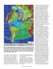
Figure 1. Topographic-bathymetric map of Atlantic-Arctic Oceans. The Gulf of Mexico and Canada      Phase 2 (Fig. 3B): Pronounced counter-
Basin are located in back-arc settings, oriented at a high angle to the Paleo-Pacific subduction  clockwise (CCW) rotation of Yucatan
zone, and were never linked to the Atlantic seafloor. The pronounced wedge-shaped oceans are      about a pole in the Florida Straits, splitting
situated between North and South America and North America and Eurasia, respectively.             the once-contiguous Callovian salt basin.
Ap—Appalachian orogen; BB—Baffin Bay; Ca—Caledonian orogen; CB—Canada Basin; EB—Eurasia           Seafloor spreading during this phase is
basin; GoM—Gulf of Mexico; In—Innuitian orogen; LS—Labrador Sea; MPB—Makarov-                     now widely accepted due, for example, to
Podvodnikov Basin; NEA—Northeast Atlantic; O-M—Ouachita-Marathon orogen; Su—Suwanne suture;       satellite gravity data (Sandwell et al., 2014).
TS—Tyrrhenian Sea; Ur—Uralian orogen.                                                             These data reveal abandoned spreading axis
                                                                                                  segments and fracture zones constraining
COBs along the original limits of the       type during the early phase of opening,               the post-salt kinematics. Paleomagnetic
Middle Jurassic Louann and Campeche         not the kinematics or the resultant back-             data (e.g., Molina-Garza et al., 1992) indi-
salt bodies (e.g., Pindell and Kennan,      arc basin geometry.                                   cate that Yucatan rotated 78 ± 11º CCW
2009) (Fig. 2). These two salt bodies                                                             since the Permian, of which 63º occurred
formed a contiguous evaporite basin in        Like a number of previous workers                   after Middle Jurassic. This rotation is
the Callovian (166.1–163.5 Ma) (e.g.,       (e.g., Molina-Garza et al., 1992; Marton              reflected by the fracture zones imaged by
Salvador, 1991). Although we lean toward    and Buffler, 1994; Imbert and Philippe,               satellite gravity data. Spreading termina-
the “wide ocean” interpretation, it is      2005; Pindell and Kennan, 2009; Kneller               tion probably occurred in the Berriasian
important to note that the alternative COB  and Johnson, 2011; Rowan, 2014) we                    (145.0–139.4 Ma), based on ODP Leg 77
interpretations only influence the crustal  favor a two-phase opening model for the               boreholes in the Florida Strait (Marton
                                            Gulf of Mexico:                                       and Buffler, 1994). Synchronously with
                                                                                                  the counter-clockwise rotation of Yucatan,
                                                                                                  complementary clockwise fan-shaped
                                                                                                  spreading probably took place in the proto-
                                                                                                  Caribbean (e.g., Pindell and Kennan, 2009).

                                                                                                    The Tehuantepec transform in western
                                                                                                  Gulf of Mexico (Figs. 2 and 3B) marks the
                                                                                                  terminal shear to Gulf of Mexico rotational
                                                                                                  opening, and forms a classic sharp transi-
                                                                                                  tion between continental and oceanic crust
                                                                                                  (Román Ramos et al., 2009). Straddling
                                                                                                  the transform is a thick Cenozoic apron,
                                                                                                  deformed at the updip end by the Neogene
                                                                                                  Quetzalcoatl extensional system, which is
                                                                                                  linked via detachments with the contrac-
                                                                                                  tional Mexican Ridges fold and thrust belt
                                                                                                  (e.g., Salomón-Mora et al., 2009).

                                                                                                    Regardless of preferred fit and timing,
                                                                                                  it is clear from refraction surveys that the

                                                 www.geosociety.org/gsatoday                                                                       5
   1   2   3   4   5   6   7   8   9   10