
Page 6 - gt1606
P. 6
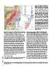
Figure 2. (A) Geological map of the study area
                                                                                              (modified from Doelling et al. [2002] in the
                                                                                              landslide area). Units: Qa—Quaternary alluvi-
                                                                                              um; Qt—Quaternary talus (Qts—sandy talus
                                                                                              cone at base of source); Qsd—deposits of the
                                                                                              Sentinel rock avalanche (in places with >1 m of
                                                                                              alluvium or colluvium cover); Jts—Temple Cap
                                                                                              Formation; Jnw—Navajo Sandstone, white;
                                                                                              Jnp—Navajo Sandstone, pink; Jnb—Navajo
                                                                                              Sandstone, brown; Jkt—Kayenta Formation,
                                                                                              Tenney Canyon Tongue; Jnl—Navajo Sand-
                                                                                              stone, Lamb Point Tongue; Jk—Kayenta Forma-
                                                                                              tion; Jms—Moenave Formation, Springdale
                                                                                              Sandstone; Jmw—Moenave Formation, Whit-
                                                                                              more Point Member; Jmd—Moenave Forma-
                                                                                              tion, Dinosaur Canyon Member. Orange
                                                                                              squares are select exposures of Sentinel Lake
                                                                                              clay beds; star shows location of Utah Geological
                                                                                              Survey (UGS) core. Circles are cosmogenic
                                                                                              exposure age sample locations. Contour interval
                                                                                              is 30 m. (B) Results of cosmogenic surface expo-
                                                                                              sure dating showing individual ages and errors,
                                                                                              mean age (solid line) of 4.8 ka, and associated
                                                                                              standard deviation (gray bar). Samples with
                                                                                              open circles were deemed outliers (see text).
                                                                                              (C) Estimated extents of Sentinel Lake at its ini-
                                                                                              tial high-stand (water level ~1420 m) and later
                                                                                              stable level (~1345 m).

GSA TODAY | JUNE 2016  River. We also estimate that ~5 million m3 have been added to the      Supplemental Data Repository1 Table S1). The boulders, which
                       deposit in the sandy debris cone at the base of the source area (Fig.  were predominantly Navajo Sandstone of each coloration facies,
                       2A), although the timing of this addition is uncertain.                exhibited a range of bedding orientations and had average dimen-
                                                                                              sions of several meters. We avoided boulders that were excessively
                         The rock avalanche source is revealed by the craggy, unweath-        friable or showed evidence of slabbing, excavation, or movement
                       ered east face of the Sentinel; a series of broken pinnacles help      after deposition (Ivy-Ochs and Kober, 2008). Iron concretions in
                       delineate the scarp. The form of the original cliff, however, is not   several sampled boulders are weathering resistant, projecting 1–2
                       well constrained. We model the source form loosely after nearby        cm above the surrounding rock and allowing estimates of boulder
                       Abraham Peak, which shares the same stratigraphy and regional          surface erosion since deposition. Sample preparation followed the
                       joint patterns. We allow the source area to extend to 2150 m above     procedures of Ivy-Ochs et al. (2006). 10Be/9Be AMS measurements
                       sea level and assume common slope angles for the different lithol-     were performed at ETH Zurich (Christl et al., 2013). Sample
                       ogies (Fig. 3B). The kinematics of the release are similarly           10Be/9Be ratios were normalized to the ETH in-house standard
                       unknown. Based on topographic reconstruction, we place the             S2007N, which is calibrated to 07KNSTD. The weighted mean
                       lowest point of the failure surface near the base of the Kayenta       full-process, measured blank 10Be/9Be ratio of (3.6 ± 2.6) × 10−15
                       Formation, which features alternating beds of sandstone and            was used for blank corrections. We calculated exposure ages with
                       shale. Rotational or translational failure through the Kayenta         the CRONUS online calculator (Balco et al., 2008) using a spall-
                       likely exploited one or more weak shale layers. Our recreated          ation production rate of 3.93 ± 0.19 atoms g−1 a−1 of the northeast
                       source has a volume of 223 million m3, yielding an estimated           North America calibration data set (Balco et al., 2009) and a time-
                       volume increase of 28% as intact rock was converted to debris          dependent spallation production model (Lal, 1991; Stone, 2000).
                       (typical fragmentation volume increase is ~25%; Hungr and              Several of the quartz mineral separates had high B contents,
                       Evans, 2004). The relatively flat and hummocky surface of the          leading to large AMS uncertainties for a few samples. Final expo-
                       rock avalanche deposit, combined with a lack of internal erosional     sure ages are shown in Figure 2B; input data and calculation
                       or depositional surfaces visible in outcrops, suggest single-event     results are reported in Supplemental Table S1 (see footnote 1).
                       catastrophic failure and emplacement.
                                                                                                Exposure dating revealed that boulders from across the surface
                       Surface Exposure Dating                                                of the slide were deposited simultaneously, indicating a single-
                                                                                              event, massive, and catastrophic rock slope failure. We identified
                         We sampled 12 boulders from across the rock avalanche deposit        three outliers in our dating results: boulder Z1, which had large
                       for cosmogenic 10Be surface exposure dating (Fig. 2B; GSA

     1 GSA Supplemental Data Item 2016070, including cosmogenic nuclide surface exposure dating sample details and results, as well as animation of the simulated Sen-
     tinel rock avalanche, is online at www.geosociety.org/pubs/ft2016.htm. You can also request a copy from GSA Today, P.O. Box 9140, Boulder, CO 80301-9140, USA;
     gsatoday@geosociety.org.

6