
Page 5 - gt1606
P. 5
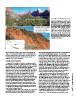
Figure 1. (A) View northeast (looking upstream
                                                                     into Zion Canyon) over the surface of the
                                                                     Sentinel rock avalanche deposit; incised gorge
                                                                     of the Virgin River at far right. Qsd—Sentinel
                                                                     rock avalanche deposits; Qts—sandy talus (see
                                                                     Fig. 2). (B) Rock avalanche deposits exposed by
                                                                     river incision, showing constituent rock types
                                                                     assessed from remote mapping; height of
                                                                     exposure is ~150 m. The upper part of the
                                                                     deposit consists primarily of Navajo Sandstone
                                                                     debris, which is characteristically shattered
                                                                     and compact, while the basal portion of the
                                                                     deposit consists of Kayenta material that has
                                                                     been deformed and tilted but often retains
                                                                     small-scale structure. See Figures 2 and 3 for
                                                                     composition of the source.

Numerical runout simulation helps confirm the hypothesized           outcrops, and extrapolation from nearby slopes. A key marker is a       GSA TODAY | www.geosociety.org/gsatoday
single-event, catastrophic failure scenario. Long-lasting geomor-    ~30 m thick bed of Springdale Sandstone, a member of the
phic and ecological effects contributing to the iconic setting of    Moenave Formation, which dips gently (~2°) to the northeast (Fig.
Zion National Park attest to the diverse impacts of large rock       2A) (Doelling et al., 2002). We assume the failure surface did not
avalanches in steep desert landscapes.                               penetrate this layer, because in-place outcrops are exposed at the
                                                                     base of the rock avalanche deposit. Another key element in our
SENTINEL ROCK AVALANCHE                                              reconstruction is a large bedrock arm flanking the southwestern
                                                                     end of the deposit; here we mapped bedrock along the river gorge
  Deposits of the Sentinel rock avalanche are deeply incised by      and under thin colluvium on two knobs above rock avalanche
the Virgin River, providing exceptional exposures over a distance    debris (see Fig. 2A). Aided by long-profile extrapolation of the
of ~2 km (Figs. 1 and 2). We observed large-scale remnant stratifi-  Virgin River underneath the slide (Fig. 3A), we approximated the
cation reflecting the composition of the source: Kayenta             topography below deposits of the Sentinel rock avalanche (Fig.
Sandstone from the base of the source is generally found along the   3B). To reconstruct the top of the slide debris, we extrapolated
basal portion of the deposit, while Navajo Sandstone from the top    existing surfaces across the incised Virgin River gorge.
of the source forms the upper part of the deposit (for details of
these lithologies see Doelling et al., 2002). Moreover, the two        Subtracting the reconstructed basal topography from the top-
materials exhibit strong textural differences caused by rock         of-slide debris surface, we calculated a mean and maximum
avalanche emplacement: the Kayenta Sandstone, with higher clay       deposit thickness of 95 m and 200 m, respectively (see Fig. 4F).
content, is highly deformed but frequently retains remnant centi-    The original deposit was 3.3 km long and 1.4 km wide, covered an
meter-scale sedimentary structure, while the massive and rela-       area of 3 million m2, and had an estimated total volume of 286
tively homogenous Navajo Sandstone exhibits compact and              million m3 (volume presumed accurate to within ±20% from trial
shattered, clast-supported deposits. Navajo Sandstone in Zion        solutions using alternate topographies). A minimum fahrboesc-
Canyon appears white in the upper part of the formation, transi-     hung angle (i.e., the ratio of fall height to path length along flow
tioning to pink and brown below through diagenetic leaching of       lines) of 20° for the Sentinel slide indicates relatively low mobility
iron (Nielsen et al., 2009). Boulders of each diagenetic facies are  for this volume compared to other terrestrial events (Lucas et al.,
found within the deposit (Fig. 1B).                                  2014). This may be related to the cross-valley flow orientation.
                                                                     Comparing the original volume of rock avalanche deposits to the
  To quantify the volume of the rock avalanche, we reconstructed     volume of material found today, we estimate that approx. 131
topography beneath the deposit and immediately after failure.        million m3, or ~45%, of debris has been eroded by the Virgin
Our reconstruction is based on field assessments, exposed

                                                                                                                                             5