
Landscape evolution in south-central Minnesota and the role of geomorphic history on modern erosional processes
Karen B. Gran, Patrick Belmont, Stephanie S. Day, Noah Finnegan, Carrie Jennings , J. Wesley Lauer, and Peter R. Wilcock
In this article
Full Text View
Volume 21 Issue 9 (September 2011)
GSA Today
Article, pp. 7-9 | Abstract | PDF (161KB)
Landscape evolution in south-central Minnesota and the role of geomorphic history on modern erosional processes
[Table: Table of Contents Introduction Valley Evolution in the Le Sueur River Modern Sediment Budget Di...]
Karen B. Gran1*, Patrick Belmont2, Stephanie S. Day3, Noah Finnegan4, Carrie Jennings5, J. Wesley Lauer6, Peter R. Wilcock7
1 National Center for Earth-Surface Dynamics, St. Anthony Falls Laboratory, 2 3rd Ave. SE, Minneapolis, Minnesota 55414, USA, and Dept. of Geological Sciences, University of Minnesota, 1049 University Drive, Duluth, Minnesota 55812, USA
2 National Center for Earth-Surface Dynamics and Dept. of Watershed Sciences, Utah State University, Logan, Utah 84322, USA
3 National Center for Earth-Surface Dynamics and Dept. of Geology and Geophysics, University of Minnesota, 310 Pillsbury Drive SE, Minneapolis, Minnesota 55455, USA
4 National Center for Earth-Surface Dynamics and Dept. of Earth and Planetary Sciences, University of California, Santa Cruz, California 95064, USA
5 National Center for Earth-Surface Dynamics and Dept. of Geology and Geophysics, University of Minnesota, 310 Pillsbury Drive SE, Minneapolis, Minnesota 55455, USA, and Minnesota Geological Survey, 2642 University Ave. W, St. Paul, Minnesota 55114, USA
6 Dept. of Civil Engineering, Seattle University, 901 12th Ave., Seattle, Washington 98122, USA
7 National Center for Earth-Surface Dynamics, and Dept. of Geography and Environmental Engineering, Johns Hopkins University, 3400 North Charles Street, Baltimore, Maryland 21218, USA
PREFACE: (open/close)
Special 2011 Annual Meeting–Themed Science Article Section
In a departure from GSA Today’s usual single lead science article format, the following four articles are meant to familiarize you with the span of geologic time represented in the Upper Midwest and the expertise of its geoscience community as we prepare to assemble at the Annual Meeting in Minneapolis. These articles also emphasize the critical role geologists are being asked to play in a society that is increasingly focused on sustainable resource use and the long-term resilience of the planet.
The first two papers treat geologic events from opposite ends of the timeline as a controlled experiment that can be studied to help understand, and thereby forecast, system responses. The latter two speak directly to our role in society.
The EarthScope USArray is currently deployed in Minnesota. Seth Stein and colleagues describe how the information coming in regarding the failed, 1.1-Ga midcontinent rift, frozen in time, will provide a way to test the two leading theories about the fundamental cause of rifting.
Next, Karen Gran and colleagues describe Holocene valley evolution. A well-constrained downcutting event is driving continuing adjustment on tributaries to the Minnesota River, the history of which has a strong influence on modern sediment loads and direct resource-management implications.
Ken Bradbury and Tony Runkel, geologists with two state surveys, partnered up for the third article, which examines how the mechanical behavior of Paleozoic rocks affects groundwater flow systems. This information is critical for sustainable groundwater use in the face of challenges ranging from the presence of live viruses deep beneath Madison, Wisconsin, USA, to evolving cones of depression that change hydraulic gradients.
Finally, Cathy Manduca introduces readers to the process of producing an educated citizenry (and a well-prepared geoscience community) that understands the ways that Earth and society are linked. The article also illustrates the need to act collectively to share experiences, develop them into classroom activities, and accurately diagnose student challenges.
Carrie Jennings, Minnesota Geological Survey
Vice Chair, 2011 Annual Meeting Organizing Committee
Abstract
The Minnesota River Valley was carved during catastrophic drainage of glacial Lake Agassiz at the end of the late Pleistocene. The ensuing base-level drop on tributaries created knickpoints that excavated deep valleys as they migrated upstream. A sediment budget compiled in one of these tributaries, the Le Sueur River, shows that these deep valleys are now the primary source of sediment to the Minnesota River. To compare modern sediment loads with pre-European settlement erosion rates, we analyzed incision history using fluvial terrace ages to constrain a valley incision model. Results indicate that even though the dominant sediment sources are derived from natural sources (bluffs, ravines, and streambanks), erosion rates have increased substantially, due in part to pervasive changes in watershed hydrology.
Manuscript received 28 Feb. 2011; accepted 29 Apr. 2011
DOI: 10.1130/G121A.1
*E-mail:
Introduction
The landscape of central Minnesota is young, having been extensively sculpted by the last glaciation. One of the biggest impacts on the post-glacial fluvial system in south-central Minnesota was the initial draining of glacial Lake Agassiz through its southern outlet, carving the Minnesota River Valley ca. 13,400 yr B.P. (Clayton and Moran, 1982; Matsch, 1983; Johnson et al., 1998). This event triggered knickpoints that continue to migrate upstream on tributaries, incising deep valleys and influencing modern erosional processes in the Minnesota River watershed (Gran et al., 2009).
The Minnesota River is impaired for turbidity and carries high suspended-sediment loads. It flows downstream to the Mississippi River and Lake Pepin (Fig. 1). Records from Lake Pepin show sedimentation rates are now an order of magnitude higher than pre-settlement rates (Engstrom et al., 2009), with 82%–92% of sediment derived from the Minnesota River (Kelley and Nater, 2000). A remarkable effort is underway to improve water quality in Lake Pepin and the Minnesota River, which ultimately requires understanding sediment loading at its source, in the primarily agricultural uplands and deeply incised tributary valleys. Here we explore how geomorphic history affects modern sediment loading in the Le Sueur River, a tributary contributing a disproportionate suspended sediment load to the Minnesota River.
Figure 1
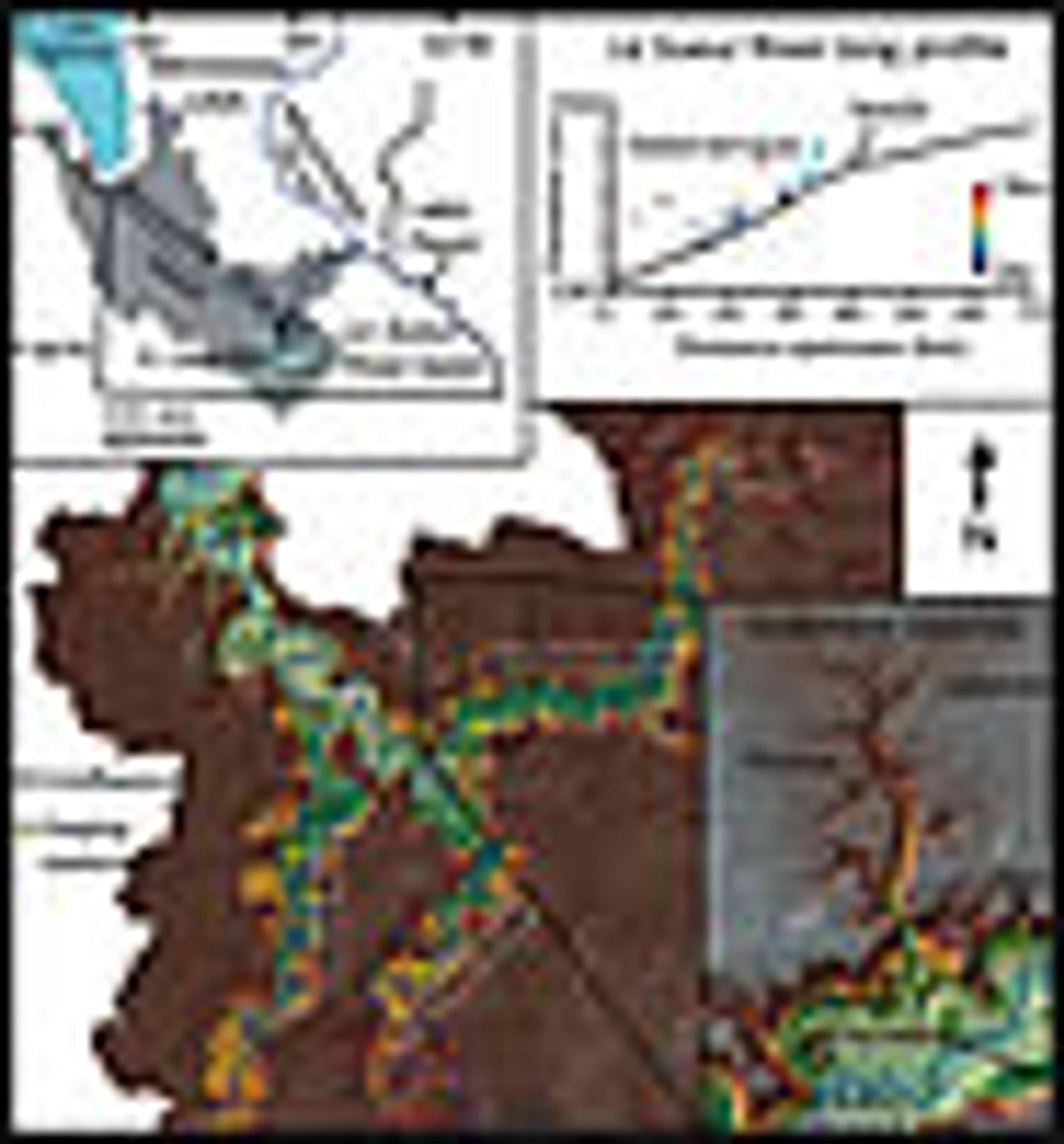
The Minnesota River Valley was carved by drainage of glacial Lake Agassiz (upper left), spawning knickpoints on tributaries like the Le Sueur River. There, the knick point has migrated 40 km upstream (upper right), forming hundreds of terraces in the process, and influencing major sediment sources (lower right).
Valley Evolution in the Le Sueur River
The Le Sueur River offers a well-constrained example of landscape evolution in a low-gradient environment following rapid base-level fall. Before incision of the modern valley, glacial Lake Minnesota occupied much of the Le Sueur watershed (Fig. 1), smoothing topography and depositing 1–2 m of glaciolacustrine sediment (Jennings, 2010). The initial impulse, base-level fall of 65 m at the mouth, is well-timed to 13,400 yr B.P. (Clayton and Moran, 1982; Matsch, 1983). The knickpoint now lies 35–40 km upstream of the mouth, and hundreds of fluvial terraces record valley incision history (Gran et al., 2009). These are strath terraces carved into glacial till. Depositional ages on 19 terraces, ranging from 13,040 to 1540 yr B.P., were determined through optically stimulated luminescence and radiocarbon dating.
A one-dimensional numerical model was constructed to determine incision history. Two models were compared: detachment-limited (bedrock-based) and transport-limited (alluvial-based). Results show that the Le Sueur River is best modeled as a bedrock channel, with downstream coarsening playing a critical role in developing the modern long profile. Although incision rates over the lower 80 km decreased from 8 mm/yr to 1.3 mm/yr, two-dimensional modeling incorporating meandering and valley widening (Finnegan and Dietrich, 2011) shows that the slowing of incision was countered by an increase in valley area, leading to fairly steady sediment export through time. The average Holocene erosion rate, calculated from excavated volume below the highest terrace, is 75,000 Mg/yr, including 50,000 Mg/yr of silt and clay.
Modern Sediment Budget
The upstream-migrating knick zone represents a geomorphic transition within the watershed affecting modern erosional processes. Within the knick zone, deep incision created high bluffs and steep ravines, while above the knick zone the landscape is dominated by low-gradient, primarily agricultural, fields. Valley incision is minor, with bluffs and ravines small or absent.
Paired gaging stations installed above and below the knick zone on three tributaries show sharp increases in total suspended solid (TSS) loads and yields within the knick zone. On the Maple River, the average upper gage TSS load from 2006–2009 was 7000 Mg/yr, increasing to 20,000 Mg/yr at the lower gage (Fig. 1), though drainage area increases by only 10%. Sediment yields increased from 8.7 to 22.5 Mg/km2/yr. Similar increases were observed on the Big Cobb (9.0 to 23.5 Mg/km2/yr) and Le Sueur Rivers (23.9 to 32.7 Mg/km2/yr) (Water Resources Center [WRC] and Minnesota Pollution Control Agency [MPCA], 2009; S. Matteson, 2010, personal commun.).
An annual- to decadal-scale sediment budget was assembled from direct monitoring, historical aerial photography, aerial LiDAR topography, terrestrial laser scanning, and geochemical sediment fingerprinting and compared with gaging records. All sediment volumes were converted into silt and clay fractions to compare with TSS loads. The modern budget indicates that the majority of sediment delivered to the mouth is derived from bluff erosion. Ravines and streambanks annually contribute ~10% each, while uplands contribute ~20%. Streambank erosion includes a large volume from channel widening. The average TSS load from 2000–2010 is 225,000 Mg/yr (WRC and MPCA, 2009; S. Matteson, 2010, personal commun.), four to five times higher than Holocene-average loads.
Discussion and Conclusions
Geomorphic history strongly influences modern erosional processes in the Minnesota River basin, with important implications for resource management. Most sediment currently comes not from agricultural fields, but from bluffs, ravines, and streambanks. This observation might lead to the assertion that excessive sediment loading in the Le Sueur is natural and not anthropogenic, but modern loads are four to five times higher than Holocene-average loads, and records downstream indicate that post-settlement sedimentation rates have increased tenfold in Lake Pepin (Engstrom et al., 2009). Although these erosional processes are natural, rates have increased due to human alterations in land cover and hydrology. Many areas in the upper Midwest have seen increases in erosion following agricultural development, and thick deposits of legacy sediment are common (e.g., Knox, 2001, 2006). In the Le Sueur, however, post-settlement alluvium is not as prevalent because the incising river lacks a geomorphic floodplain over much of the knick zone (Belmont, 2011). The sensitivity of the knick zone to erosion is an artifact of the geomorphic history of the watershed, which must be considered as management actions are taken to lower sediment delivery to the Minnesota River. This becomes increasingly important as mean annual precipitation and peak flows have been increasing in the Minnesota River basin (Novotny and Stefan, 2007), requiring a greater degree of resiliency within the watershed to combat hydrologic alterations.
Acknowledgments
Funding was provided by the Minnesota Pollution Control Agency and the National Science Foundation STC program via the National Center for Earth-Surface Dynamics (EAR-0120914).
REFERENCES CITED
- Belmont, P., 2011, Floodplain width adjustments in response to rapid base level fall and knickpoint migration: Geomorphology, v. 128, p. 92–102, doi: 10.1016/j.geomorph.2010.12.026.
- Clayton, L., and Moran, S.R., 1982, Chronology of late-Wisconsinan glaciation in middle North America: Quaternary Science Reviews, v. 1, p. 55–82.
- Engstrom, D.R., Almendinger, J.E., and Wolin, J.A., 2009, Historical changes in sediment and phosphorus loading to the upper Mississippi River: Mass-balance reconstructions from the sediments of Lake Pepin: Journal of Paleolimnology, v. 41, p. 563–588.
- Finnegan, N.J., and Dietrich, W.E., 2011, Episodic bedrock strath terrace formation due to meander migration and cutoff: Geology, v. 39, p. 143–146.
- Gran, K.B., Belmont, P., Day, S.S., Jennings, C., Johnson, A., Perg, L., and Wilcock, P.R., 2009, Geomorphic evolution of the Le Sueur River, Minnesota, USA, and implications for sediment loading, in James, L.A., Rathburn, S.L., and Whittecar, G.R., eds., Management and restoration of fluvial systems with broad historical changes and human impacts: Geological Society of America Special Paper 451, p. 119–130.
- Jennings, C.E., 2010, Draft digital reconnaissance surficial geology and geomorphology of the LeSueur River watershed (Blue Earth, Waseca, Fairbault, and Freeborn counties in south-central MN): Minnesota Geological Survey Open-File Report 10-03, map, report, and digital files: ftp://mgssun6.mngs.umn.edu/pub4/ofr10_03/ (last accessed 13 June 2011).
- Johnson, M.D., Davie, D.M., and Pedersen, J.L., 1998, Terraces of the Minnesota River valley and the character of glacial River Warren downcutting, in Patterson, C.J., and Wright, H.E., Jr., eds., Contributions to Quaternary studies in Minnesota: Minnesota Geological Survey Report of Investigations 49, 208 p.
- Kelley, D.W., and Nater, E.A., 2000, Historical sediment flux from three watersheds into Lake Pepin, Minnesota, USA: Journal of Environmental Quality, v. 29, no. 2, p. 561–568.
- Knox, J.C., 2001, Agricultural influence on landscape sensitivity in the Upper Mississippi River valley: Catena, v. 42, p. 193–224.
- Knox, J.C., 2006, Floodplain sedimentation in the Upper Mississippi Valley: Natural versus human accelerated: Geomorphology, v. 79, p. 286–310.
- Matsch, C.L., 1983, River Warren, the southern outlet of Lake Agassiz, in Teller, J.T., and Clayton, L., eds., Glacial Lake Agassiz: Geological Association of Canada Special Paper 26, p. 232–244.
- Novotny, E.V., and Stefan, H.G., 2007, Stream flow in Minnesota: Indicator of climate change: Journal of Hydrology, v. 334, p. 319–333.
- Water Resources Center (WRC), Minnesota State University, Mankato, and Minnesota Pollution Control Agency (MPCA), 2009, State of the Minnesota River: Summary of surface water quality monitoring 2000–2008, 42 p.
