
In this article
Authors
Bilal U. Haq*
Sorbonne University, Paris, France, 75006; Smithsonian Institution, Washington, D.C., 20024, USA
John D. Milliman
William & Mary, Williamsburg, Virginia 23185, USA
Abstract
River deltas occupy only ~0.65% of Earth’s land surface, but collectively house ~4.5% of the global population and account for more than 6% of the global GDP. Because of ongoing human interventions in the past century (river diversions, groundwater and petroleum extraction, and urbanization), deltas are coming under additional and intense threat from climate change and the impending sea-level rise. Many high-latitude and tropical deltas where population pressure is low and human modification is minimal face less peril for the foreseeable future, but densely populated deltas, especially those in Asia with extreme urbanization and environmental pressures, will be more susceptible to land loss and drowning. Here we consider six key deltas—Mississippi, Yangtze, Niger, Bengal, Nile, and Indus—emphasizing recent findings and consensus as to their health and how human activities have brought these vulnerable ecosystems perilously close to or beyond the point of no return.
*bilhaq@gmail.com
CITATION: Haq, B.U., and Milliman, J.D., 2023, Perilous future for river deltas: GSA Today, v. 33, p. 4–12, https://doi.org/10.1130/GSATG566A.1. © 2023 The Authors. Gold Open Access: This paper is published under the terms of the CC-BY-NC license. Printed in the USA.
Manuscript received 6 Mar. 2023. Revised manuscript received 30 May 2023. Manuscript accepted 26 July 2023. Posted 7 Sept. 2023.
© The Geological Society of America, 2023. CC-BY-NC.
https://doi.org/10.1130/GSATG566A.1
Introduction
Deltas are low-lying extensions, formed off of river mouths by the deposition of river-borne sediment and organic material as the river approaches the coastal zone. Sediment influx promotes the delta’s seaward progradation, and subsidence caused by the dewatering and compaction of sediments that are deposited above a flexing lithosphere produces the capacious sedimentary accommodation that allows the delta to thicken. While the seaward limit of a delta is easy to define, its landward extent, and thus its land area, is subject to interpretation; for example, all low-lying land seaward of a break in topographic gradation versus land lying at less than a specified elevation versus land area seaward of the deltaic channel. The area of the Amazon River Delta, for instance, can be considered to be as large as 100,000 km2 (Ericson et al., 2006) to 300,000 km2 (da Costa et al., 2019), or as small as 84,000 km2 (Edmonds et al., 2020), of which only 1970 km2 lie at elevations lower than 2 m (Syvitski et al., 2009). Reported areas and populations also depend on how the delta is defined—that is, by geographic, economic, or political criteria. For example, Edmonds et al. (2020) define the Pearl River Delta by geomorphic criteria (5600 km2), whereas the Pearl River Delta Economic Zone (39,000 km2; Tang et al., 2016) includes islands and mountains locally higher than 900 m. The former, according to Edmonds et al. (2020), has a population of 9.5 million, whereas the latter includes the megapolises of Guangzhou-Shenzhen, with a combined population of more than 24 million.
Due to the fertile nature of their river-derived sediments, abundant freshwater, diverse ecosystems, and inland and seaward access, deltas were centers of early human civilization, particularly in arid climates, e.g., Nile (Egypt), Tigris-Euphrates (Mesopotamia), and Indus (Indus Valley civilization; Macklin and Lewin, 2015). Over the ensuing millennia, the fertile deltas have served as agricultural, fishing, and commercial centers. Although their collective areas account for less than 1% of the global land surface, deltas are among the most densely urbanized and productive landforms on Earth. The major socioeconomic role of deltas is perhaps best illustrated in Table 1, where 12 large deltas collectively occupy 350,000 km2, less than 0.3% of Earth’s land area. Two of the 12 deltas—Amazon and Lena—have sparse populations and little commerce; the other 10 deltas (~0.25% of the global land area) house 245 million people, ~3% of the world’s population, and a collective GDP that annually exceeds US$4.8 trillion.
Table 1

The Edmonds et al. (2020) database includes 1178 deltas larger than 1 km2 (Fig. 1) with a total area of 848,000 km2 and 339 million inhabitants. Using a larger database, Syvitski et al. (2022) estimated the global delta area as 855,000 km2. According to data from Edmonds et al. (2020), deltas >1000 km2 in area collectively cover 752,000 km2, deltas between 10 km2 and 1000 km2 total 31,000 km2, and deltas between 1 km2 and 10 km2 cover 2,000 km2; deltas located between 25°N and 5°S occupy ~68% of the global deltaic land area (Fig. 2). As of 2017, Asian deltas housed 262 million people, 77% of the global delta population, with an average population density of 880/km2. In contrast, the 672 non-Asian deltas listed by Edmonds et al. (2020) have 76 million inhabitants, with an average population density of 222/km2. Many arctic and tropical deltas are particularly underpopulated. The arctic deltas of the Lena, Pechora, Yana, Indigurka, MacKenzie, and Yukon rivers (collectively 60,000 km2 of land surface; Walker, 1998) have an average population density of only 0.4/km2, and the Amazon, Orinoco, and Congo Deltas (130,000 km2) have an average population density of only 8/km2. Interestingly, however, one of the most densely populated deltas is the Neva Delta near St. Petersburg in Russia (12,700 inhabitants/km2).
Figure 1
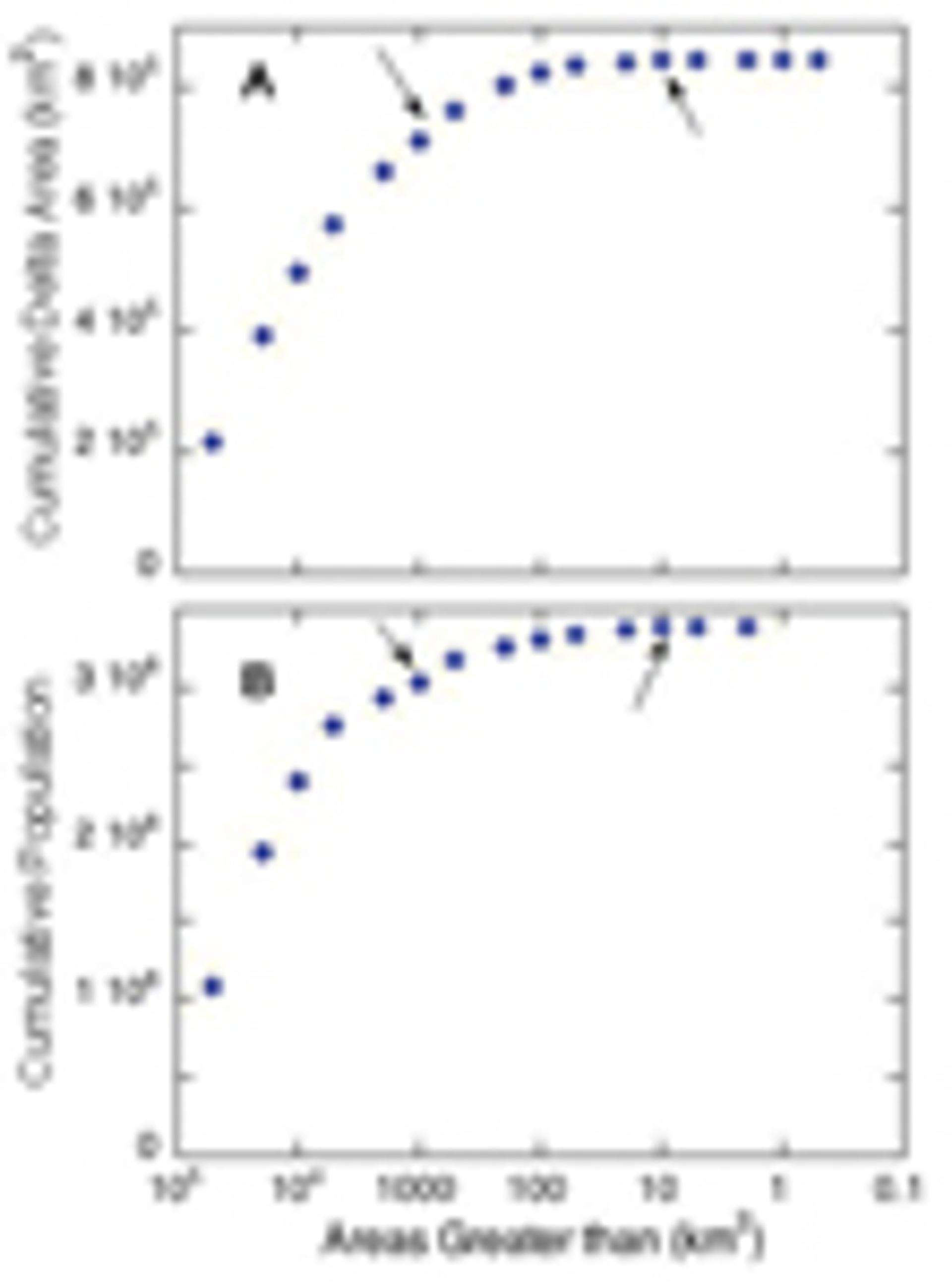
Cumulative areas (A) and populations (B) of global deltas greater than 1 km2, based on data reported by Edmonds et al. (2020). Arrows delineate deltas >1000 km2 and 10 km2.
Figure 2
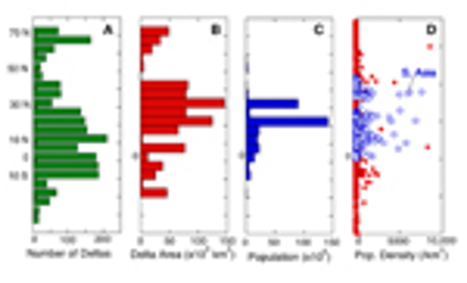
Latitudinal distribution of (A) delta numbers >1 km2, (B) combined delta area, (C) population, and (D) population density. Data from Edmonds et al. (2020).
Deltas Under Stress
Despite a recent overall gain observed in deltaic land area worldwide (Nienhuis et al., 2020), many of the populated deltas that have significant socioeconomic importance are either eroding or sinking, or both, hence such popular media headlines as “Death of the Indus Delta;” “Mississippi Delta: land loss and erosion;” “Can the Ebro Delta be saved from erosion?;” and “Millions at risk as world’s deltas sink!” In nearly all cases, the problem of disappearing deltaic land stems directly or indirectly from a combination of local, regional, and global human actions (Syvitski, 2008).
In many deltas, a primary problem is caused by both upstream river and deltaic modification. Upstream dams can moderate or eliminate seasonal fluxes in water, and dredging of river channels and dikes along the riverbanks can prevent floodwaters from topping onto adjacent land. While such alterations in river and sediment flow protect human habitations, they also prevent new sediment from spreading over floodplains that would offset natural and human-enhanced in situ subsidence. Natural subsidence rates can be rapidly accelerated by groundwater or oil and gas withdrawal from the substrate. Local extensive groundwater pumping that began in the 1970s, together with upstream damming of the Chao Phraya River, for example, resulted in subsidence of as much as 1.6 m in Bangkok by 1988 (Nutalaya et al., 1996; Bidorn et al., 2021).
Climate change will only exacerbate the stresses on river deltas. As Earth’s oceans warm and land-based glaciers melt, there is a corresponding volumetric increase in oceanic waters, thus leading to rising sea level that can be measured globally, which when compared to the 1990s, is projected to rise 30 cm by the year 2050 and most likely exceed 1 m by 2100. This melt, combined with reduced sediment influx and accelerated subsidence, means that relative sea-level rise (SLR) in many deltas has exceeded, or will soon exceed, 3–8 mm/yr—a sobering scenario for deltaic land that often lies only 1–2 m above present-day sea level.
Deltaic and Coastal Response to Accelerating Sea-Level Rise
In its sixth Assessment Report, the Intergovernmental Panel on Climate Change (IPCC) revised its estimate of the increase in Earth’s mean surface temperature upward to 1 °C since the late nineteenth century. The IPCC projects total warming to reach 1.5 °C between 2030 and 2050 (IPCC, 2022). A major consequence has been the acceleration in the rate of SLR. In 2019, the IPCC revealed that global mean sea level (GMSL) has risen at a rate of 3.4 mm/yr since the 1990s, compared to 1.2–1.7 mm/yr during the first half of the twentieth century (IPCC, 2019). Warming-related acceleration in melting of mountain glaciers and the Greenland and Antarctic ice sheets has contributed ~50% to this increase (Allison et al., 2021); much of the rest is attributed to the steric (thermal) expansion of ocean water, and a smaller amount to permanent transfer of aquifer water to the ocean. Projected GMSL rise may be 1.1 m (IPCC, 2022) or as much as 2.5 m by the year 2100, the higher estimate produced by NOAA models that take into consideration greater instability of western Antarctic ice sheet (Sweet et al., 2022). The 1–2.5 m of SLR will cause the following changes (to a varying degree) on most deltas of the world.
Intensified flooding: Due to their low gradients, deltas are at greater risk when the sea rises rapidly, particularly in the absence of sedimentary replenishment. Deltas (e.g., Bengal, Orinoco, Niger, Indus, Mississippi, and Chao Pharaya) and nearby low-lying areas (e.g., Sumatra, Borneo, the low countries of Europe, southern Baltic, and the U.S. Gulf Coast) that are also undergoing enhanced subsidence will be prone to increasing inundation. It is now well established that warmer seas mean more energy to convert to tropical cyclones, and both the Atlantic and Indian Oceans show an unmistakable trend toward increased frequency of stronger tropical storms that could greatly accelerate coastal destruction (see e.g., Lima et al., 2021; Singh et al., 2000).
Increased erosion: Following SLR, and in part due to decreased sediment supply, many beaches are in retreat caused by erosion. Along the mouth of the Nile Delta, for example, the promontories are eroding rapidly so that the coastline is increasingly wave-dominated (e.g., Darwish et al., 2017). Protective barrier islands, bordering the coasts and formed by repeated wave action, may not be able to keep pace with rapid SLR, and thus may drown when sediment influx cannot keep pace.
Increased salt-water intrusion: Salt-water intrusion into estuaries and coastal aquifers is a serious issue that has intensified where groundwater has been removed for human consumption; SLR will only accelerate salinization. In the Bengal Delta, for example, salt-water intrusion has been observed up to 240 km upstream during dry seasons when the river flow is impeded due to upriver water sequestration (e.g., Akter et al., 2016). In Bangkok, aquifer contamination has been encouraged by excessive and rapid groundwater withdrawal from the Chao Pharaya Delta (Stoecker et al., 2013).
Ecosystem disruption: Delta wetlands (marshes, bogs, mangrove swamps, and estuaries) normally keep pace with gradual SLR, but when vertical accretion is reduced due to a deficit of sediment influx, these ecosystems can rapidly degrade. Another factor is the warming-related augmentation of dissolved CO2 in the surface waters that leads to an increase in ocean acidification. The IPCC estimates that the ocean has taken up as much as 30% of all anthropogenic CO2 emission since the 1980s (IPCC, 2021). The increased acidification is injurious to the delicately balanced mixed-water ecosystems of the deltas. The permanent disruption of such habitats has a snowballing effect on the local flora and fauna; fisheries, for example, are a major economic resource that suffers immediately from deltaic damage.
In 1996, we published a volume of collected papers (Milliman and Haq, 1996) that discussed the impacts of river damming, land subsidence, and changes in relative sea level on deltaic and other coastal environments. The ensuing 27 years have witnessed a surfeit of papers and books recording the increasing reality of deltaic change and loss, particularly in light of climate change. Here, we revisit some of the deltas discussed in Milliman and Haq (1996), emphasizing current observations and consensus of the international scientific community. For the sake of brevity, we emphasize results mostly published in the past 20 years; see Syvitski et al. (2022) and Nienhuis et al. (2023) for more detailed reviews.
The Mississippi Delta
The Mississippi River drains more than 40% of the contiguous USA. The delta that has formed at the end of this 5900-km-long river has an area of 51,000 km2 (Edmonds et al., 2020), of which 14% (7140 km2) lies at elevations <2 m (Syvitski et al., 2009). Given its importance as a transportation hub (New Orleans, southern Louisiana, and Baton Rouge collectively account for US$11 billion of annual economic activity), the river and its delta have been heavily affected by human modifications for the past 200 years. In order to regulate flow, irrigate fields, and manage river navigation, as well as harness hydroelectric power, more than 40,000 dams of various sizes have been constructed on this watershed, 1220 of which are higher than 15 m (Milliman and Farnsworth, 2011). Following the New Madrid Earthquake in 1811–1812, the river discharged ~400 million tons of sediment annually to the lower Mississippi. After dam construction in South Dakota during the early 1950s, sediment transport decreased dramatically, and after 1965 only ~100–150 million tons of sediment reached the lower Mississippi annually. To prevent flooding of the region’s lowlands, more than 1000 km of levees have been built along the banks of the delta, thus preventing lateral escape of water and sediment to the subsiding delta (Blum and Roberts, 2009). Moreover, construction of 30,000 km of canals plus the laying of pipelines along the delta have not only markedly altered the configuration of the delta but also resulted in increased salinization of the lower delta and its groundwaters.
Oil and gas production has greatly affected the delta, increasing from 35 million barrels of oil recovered in 1945 to 445 million in 1970 before dropping to ~30 million barrels in 2019 (Day et al., 2020). The effect upon delta subsidence can be seen in the relative sea-level record at Grande Isle, west of the delta’s bird’s foot. From 1940 to the late 1960s, the mean subsidence rate was 3.5 mm/yr—~1.4 mm/yr greater than global SLR. Between 1970 and 1995, SLR at Grande Isle accelerated to ~13 mm/yr. Of the 500 mm SLR measured at Grande Isle between 1932 and 2010, ~100 mm was due to natural subsidence and 300 mm was due to petroleum extraction (Day et al., 2020; Blum et al., 2023). The uncompensated subsidence has led to the loss of ~5000 km2 of wetlands since 1932, with most of the loss since 1970 (Couvillion et al., 2017; Blum et al., 2023). As hydrocarbon production has declined, so have subsidence rates, although this decline has been partially counterbalanced by a recent acceleration of SLR (~10 mm/yr) in the western Gulf of Mexico (Dangendorf et al., 2023).
The Yangtze Delta
With an area of ~18,000 km2, of which 40% lies at elevations <2 m, and a population of 31 million, the Yangtze Delta is one of the most densely populated (1800 inhabitants/km2) and economically productive (US$2.2 trillion/yr) deltas in the world. The delta wetlands, with an average elevation of ~2 m, have been heavily reclaimed since prehistoric times and are now the site for Shanghai (population >31 million), whose annual GDP exceeds US$20 trillion (Table 1).
The Yangtze River, with the largest Asian river drainage basin (18,300 km2), once had the fifth largest global sediment input, ~500 million tons/yr. Since the 1950s, however, more than 50,000 dams of various sizes have been built along the Yangtze watershed, resulting in a decline to ~300 million tons/yr by the late 1990s. With the construction of the world’s largest containment system, the Three Gorges Dam, between 2000 and 2004 (Fig. 3), annual sediment flux to the delta dropped quickly to ~150 million tons by 2005, leading to subaqueous erosion and delta recession (Yang et al., 2011, 2014; Luo et al., 2017). Erosion on the prodelta and mouth bar since 2010 has averaged 200 million m3/yr, compared to 200 m3/yr of accretion before 1978 (Li et al., 2020; Luan et al., 2021). As sediment discharge from the Yangtze declines to less than 100 million tons/yr, further recession of the delta front is almost assured (Luo et al., 2017). Despite the marked decrease in sediment flux—and in stark contrast to the Mississippi Delta—coastal wetland areas on the Yangtze Delta have increased considerably, adding 240 km2 (22%) of coastal wetland between 1997 and 2010, largely due to coastal reclamation and the tidal forcing of subaqueous sediment back onto the delta plain (Yang et al., 2021; Zhang et al., 2022).
Figure 3
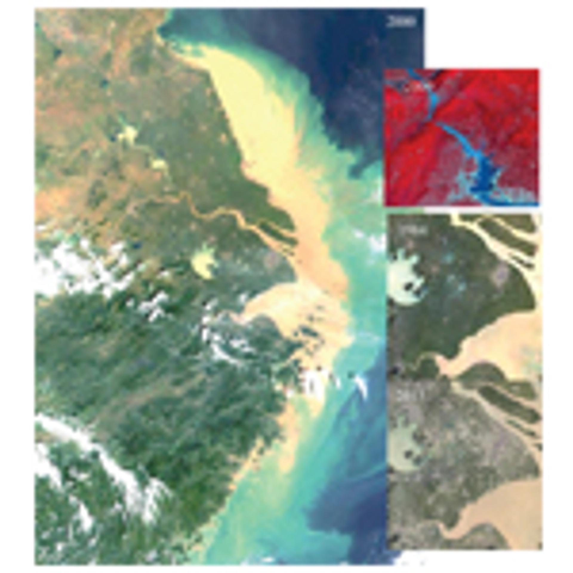
The Yangtze Delta hosts several megacities, including Shanghai (gray area south of the river mouth). Insets: top: A 2009 false-color image of the Three Gorges Dam (the world’s largest) on the Yangtze River, which sequesters much of the sediment and water from reaching the delta; middle: A 1984 Landsat image of the Yangtze River mouth and the city of Shanghai; bottom: The same area in a 2013 image showing the growth of greater Shanghai into a mega-metropolis. Credit: NASA archives.
The delta has also had a major problem with subsidence in large part due to groundwater pumping. Between 1950 and 1965, subsidence in Shanghai averaged 1100 mm (~73 mm/yr), but locally subsidence was as great as 2600 mm (~173 mm/yr; Xu et al., 2012, 2016). Groundwater withdrawal that was >8 × 10⁷ m3/yr in 2000–2004 was reduced to <1 × 10⁷ m3/yr by 2016 through groundwater recharge (He et al., 2019). These measures have helped to achieve a sharp drop in subsidence; since 2011, in fact, recharge has exceeded withdrawal. Shanghai’s rapid population increase, from 5.6 million in 1980s to 34 million in 2022, however, has resulted in an explosion in urban construction, particularly high-rise buildings, which has resulted in 300 mm of additional subsidence since 1980 (Yang et al., 2020), an average of ~7.5 mm/yr. Given the low-lying nature of this subsiding delta (40% <2 m in elevation), rising sea level and increased coastal erosion suggest serious future problems for this economically vibrant delta.
The Bengal Delta (Ganges, Brahmaputra, and Meghna Rivers)
The Bengal Delta (Fig. 4) is the world’s second largest delta (80,200 km2), ~40% of which lies in India and the rest in Bangladesh, and has one the world’s densest populations, with 105 million inhabitants (1500/km2), including the megapolises of Dhaka (22 million) and Kolkata (15 million). Of the one billion tons of sediment delivered annually to the Bengal Delta (Milliman and Farnsworth, 2011), most are contributed by the Ganges and Brahmaputra River systems, primarily during the summer monsoon. For much of the year, however, the delta is rain-deficient; rainfall during the winter monsoon, between November and March, accounts for only ~5% of the annual total. Additionally, flow has been dramatically reduced by the diversion upstream of Ganges waters into the Hooghly Channel at the Farakka Barrage in India to supply water to Kolkata. Reduced freshwater flux to the delta has resulted in increased saltwater intrusion into both streams and groundwater.
Figure 4
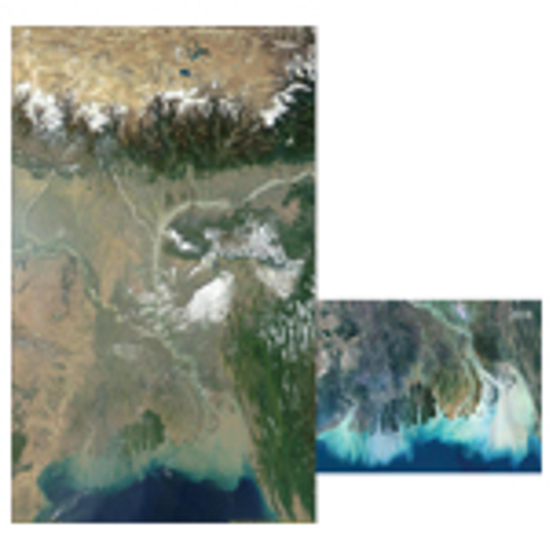
The Bengal Delta is a confluence of three major rivers (Ganges, Brahmaputra, and Meghna). The choking of sediment supply by upstream damming produces sediment and water deficits to the whole delta, causing increased subsidence, salt-water intrusion, and ecosystem impairment. Inset: Higher-resolution image of the eastern delta mouth. Credit: NASA archives.
Most freshwater during dry months comes from the pumping of groundwater, retrieved through hundreds of thousands of mostly shallow tube wells (<150 m in depth). Collectively, tube wells provide more than 30 km3/yr of groundwater to Bangladesh; 90% is used for irrigation, and the remaining 10% furnishes 98% of the pathogen-free drinking water (Shamsudduha et al., 2019). However, when the populace living on the delta changed their freshwater supply from surface water to groundwater, they unwittingly tapped through a naturally occurring layer of arsenic in the delta soil. As much as half the population living on the delta, in both Bangladesh and neighboring West Bengal, is now thought to suffer from the effects of arsenicosis (Kinniburgh and Smedley, 2001; Harvey et al., 2005).
Another predictable result of groundwater withdrawal has been accelerated subsidence. Buried salt kilns and mangrove stumps in the southwestern delta, known as the Sundarbans, indicate 4–5 mm/yr of subsidence over the past 300 years (Hanebuth et al., 2013), but subsidence varies significantly on the delta (see Akter et al., 2016). Recent satellite-derived data indicate that average subsidence may be in the range of 2–3 mm/yr (Becker et al., 2020) but still varies greatly. Another study indicates that at least a part of the tidally dominated Sundarbans may be keeping pace with the SLR (Rogers et al., 2013). If the subsidence rates do not worsen, the lower delta may maintain its stability relative to rising sea level.
The coastal delta also suffers from severe cyclonic storms that exacerbate flooding and cause widespread devastation; storm surges can have tidal highs of up to 6 m that can reach over 200 km inland. To manage water supply during dry seasons, levees have been built along the channel, and to protect human habitations from coastal floodings, the World Bank financed the building of a series of 139 polders (a 5700-km network of sea walls) over the past several decades. Over the long term, however, these infrastructures have disrupted the delicate balance between the flow of water and sediment necessary to keep the land above high-flood levels and protect farmlands. Moreover, these embankments also prevent the annual renourishment of the soil and assure additional noncompensated subsidence of the delta. Modelers have reached the conclusion that to maintain long-term health, these polders must allow seasonal flooding rather than continually keeping it out (Cornwall, 2018).
The Niger Delta
The Niger Delta lies at the confluence of three rivers—Niger, Benue, and Imo (Fig. 5)—which collectively drain a catchment area of 2.2 million km2. Depending on how one delineates its area (29,900 km2, Kuenzer et al., 2014; 34,500 km2, Edmonds et al., 2020; 59,000 km2, Ericson et al., 2006; 70,000 km2, Ohwo, 2018), the delta is home to between 16 million and 30 million inhabitants. The average elevation is ~3 m above mean sea level, of which 15,300 km2 lie at or lower than 1 m above sea level (Ohwo, 2018). As such, much of the delta is either permanently or seasonally flooded, thus supporting extensive mangrove swamps. During the wet season, heavy rains can flood towns such as Port Harcourt (which handles nearly 60% of Nigeria’s shipping), backing up drainage and sewage systems and causing water contamination, which poses serious health hazards. Damming of the upper Niger and Benue Rivers for hydroelectric power has significantly reduced the sediment influx to the delta. Reduced freshwater flow during dry seasons has led to greater intrusion of saline waters into the delta’s groundwater and estuaries. Natural subsidence rates appear to average 2–3 mm/yr (Collins and Evans, 1986).
Figure 5
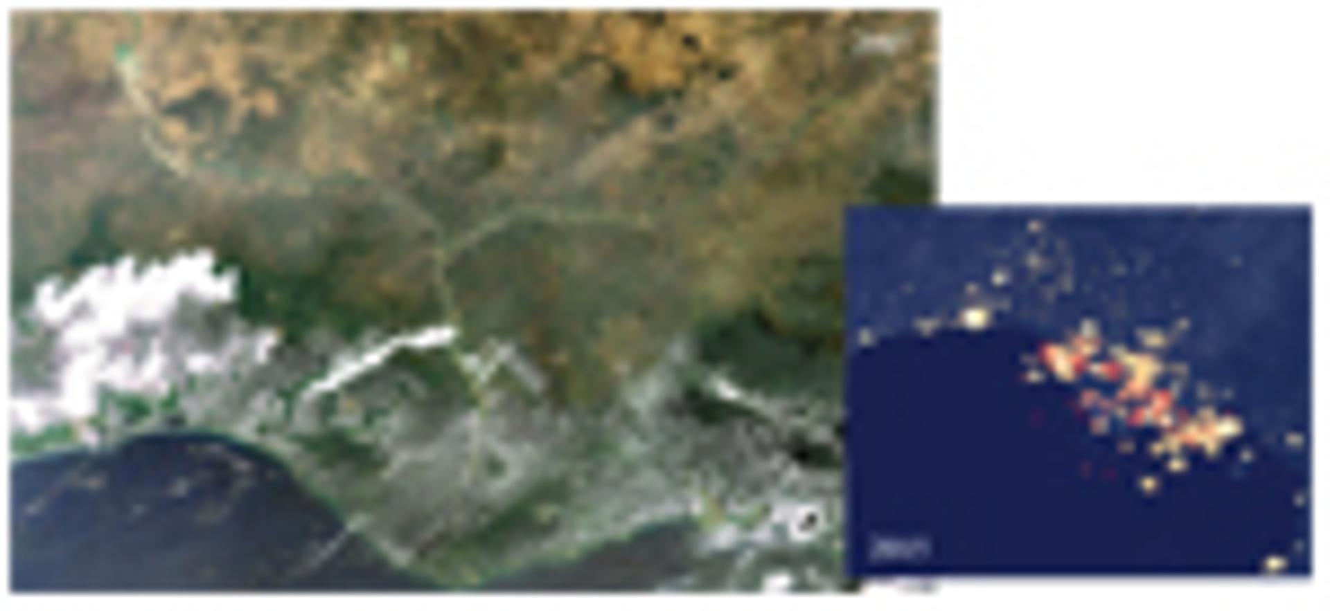
The lower Niger River System, confluence of the Niger River (from the left) and the Benue River (from right) and the Niger Delta with its extensive oil-production infrastructure. This delta provides an extreme example of the intensified subsidence around production platforms due to oil and gas extraction and is among the world’s most polluted deltaic systems. Inset: Night view of the delta mouth showing intensive flaring of waste gas emanating from oil wells. Credit: ESA and NASA archives.
Hydrocarbon exploration and production has provided the major economic activity in the delta since the 1960s, making up >90% of Nigeria’s foreign exchange. Production-related oil spills and the practice of gas flaring (much of it in the economically important mangrove areas) are frequent and have been identified as the most common causes of pollution and environmental degradation of both surface and groundwater (Nwankwoala and Ngah, 2014). Such exploration also has opened up remote areas, bringing attendant detrimental consequences to the rainforests and swamps, which serve as spawning grounds for finfish and shellfish. The major impact of petroleum (and groundwater) withdrawal has been accelerated subsidence. Recent measurements around oil platforms show average subsidence rates of 550 mm/yr (Abija et al., 2020). The rapid urbanization of Lagos (population 25 million) has led to subsidence rates reaching as high as 87 mm/yr in the city’s coastal areas (Ikuemonisan and Ozebo, 2020).
A global SLR of 1 m by the end of the twenty-first century would flood much of the Niger Delta and exacerbate the concerns mentioned above. Disappearance of barrier islands due to further acceleration of erosion following ocean transgression would result in the destruction of mangroves and disruption of many of the existing fishing activities, as well as the elimination of future brackish-water aquaculture sites. The economic and societal impacts are difficult to predict, but they could force up to 80% of the delta’s population to seek higher ground (IPCC, 2022).
The Nile Delta
Since the mid-1960s, Egypt’s Nile Delta (Fig. 6) has served as a prime example of the effect that dams can have on the lower river and its delta. The Aswan Dam, completed in 1964, has prevented most of the Nile’s freshwater and nearly all of its sediment from reaching the delta. Theoretically, the Nile no longer has an “active” delta, but rather is a wave-dominated coastal plain (Stanley and Warne, 1993). Although the delta covers only 2% of Egypt, it is home to 41% of its population. More than 45 million Egyptians live on or near the lower Nile and its delta, making it more densely populated than the Bengal Delta (1600 vs. 1500 inhabitants/km2).
Figure 6
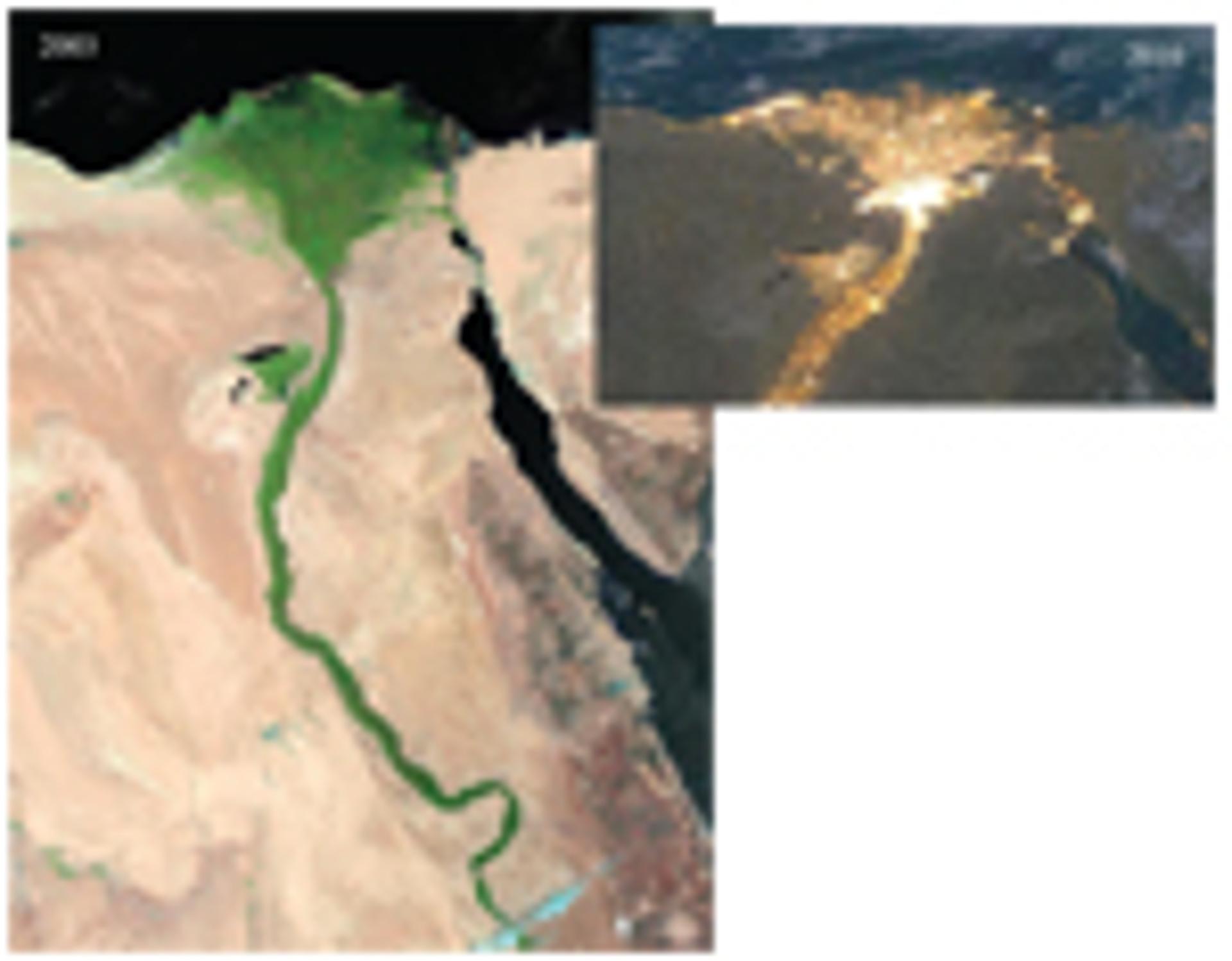
The Nile River and its delta. The green area along the river is the only fertile strip until the delta is reached to the north. Due to major upstream damming at Aswan (near the bottom of the image) that has caused both water and sediment deficit, the Nile Delta is no longer an “active” delta, but rather a transgressive shore along its northern edge. Inset: Nile Delta at night. A 2010 image from space shows the heavy population pressure in the delta—the brightly lit area in the upper middle is the location of greater Cairo, a megapolis of over 20 million inhabitants. Credit: NASA archives.
Between the years 1500 and 1900, the Rosetta Promontory prograded 15 km. Soon after construction of the Low Aswan Dam between 1899 and 1902, however, the promontory began retreating, ~2 km until 1964 (30 m/yr), and 6 km by 1995, mostly after the construction of the High Aswan Dam, built between 1960 and 1970 (200 m/yr; Sanhory et al., 2022). Delta loading due to urbanization and excessive groundwater withdrawal led to local subsidence rates of between 4 and 20 mm/yr (Becker and Sultan, 2009; Stanley and Clemente, 2017; Saleh and Becker, 2019; Rateb and Abotalib, 2020).
Under normal conditions, Egypt’s coastline is protected by sand dunes 1–5 m in height. In the past, four brackish-water lagoons behind the dunes supplied a large percentage of Egypt’s fish catch, especially sardines. Since the completion of the High Aswan Dam, however, the lack of water, replenishing sediments, and high subsidence has led to greater shoreline erosion and near-collapse of fisheries in the delta. In places, the shoreline has retreated as much as 10 m/yr. Surprisingly, however, post-High Aswan Dam population explosion and agricultural activity–related contamination by sewage and fertilizer runoff, while causing eutrophication in the delta lagoons, has also led to tripling of fish catch in ocean waters offshore, as compared to pre-Aswan values (Oczkowski et al., 2009). The long-term adverse health effects of the widespread human consumption of fish rich in both biological contaminants and trace metals (Morsy et al., 2020) is as yet unknown, but it should be of grave concern.
The projected 1 m SLR by the end of the twenty-first century increases the chance of promontories being cut back to produce a straighter and smoother wave-dominated coast. Lagoonal areas may shrink due to filling on their seaward sides (Stanley and Clemente, 2017). The loss of wetlands in the delta will also eliminate ecological niches for waterfowl and migrating birds and cause a loss of biodiversity. Widespread salinization (predicted to be up to 100 km inland by 2050) and extensive loss of agricultural land and products are also anticipated. Current trends will inevitably lead to higher pollution levels around the lagoons as the natural wetlands are increasingly converted to anthropogenic use.
The Indus Delta
The Indus Delta (Fig. 7) is 12,700 km2 in area, of which 4750 km2 (37%) lies at elevations lower than 2 m (Caldwell et al., 2019; Syvitski et al., 2022). The Indus River has served as a major source of water for much of lower Pakistan, particularly since the construction of a series of upstream barrages and canals in the second half of the twentieth century, which allowed increased irrigation to the arid interior. Present-day discharge past the downriver Kotri barrage for most years is less than 5 km3/yr, compared to >100 km3/yr prior to 1960. These barrages have also trapped the river’s sediment, down from ~250 million tons/yr prior to 1940 to <5 million tons/yr by 2010 (Milliman and Farnsworth, 2011). This sediment deficit has led to an average delta retreat of 16 to >60 m/yr (Hashmi and Ahmad, 2018). Stated differently, between 1944 and 2013, the delta lost 12.7 km2/yr, fully 14% of its surface area (Syvitski et al., 2013).
Figure 7
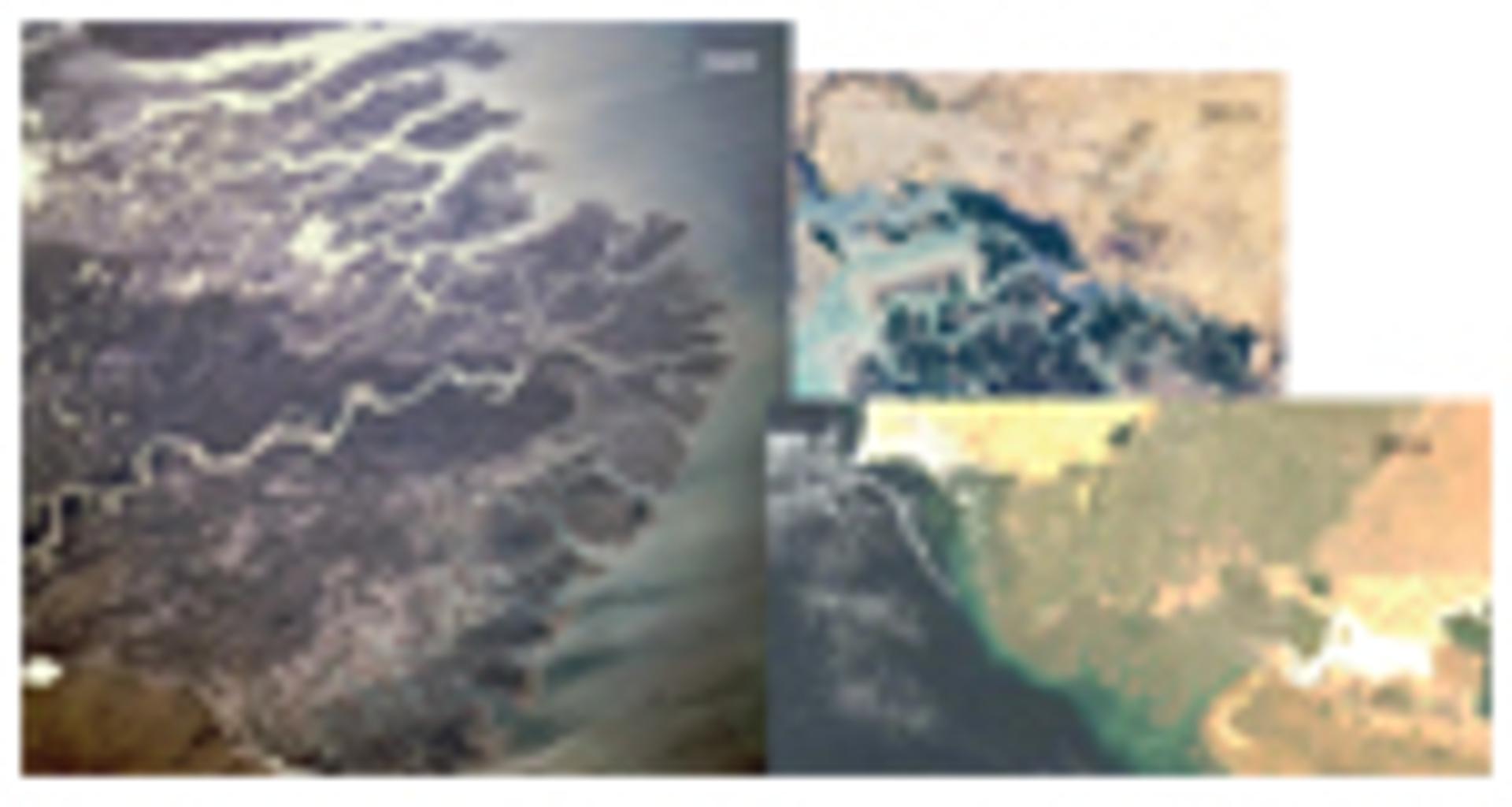
The terminus of the Indus River and its extensive delta system as seen from the west looking eastward. The Indus Delta is a highly dynamic system that is affected by upstream and downstream influences and by seismicity associated with the nearby Makran subduction zone, as well as by tsunamis. The number of distributary channels has reduced from 17 in 1861 to just one today, largely due to upstream diversions and damming. Instead of a fluvially dominated delta, it is now mostly a tidally controlled system, where the mangrove ecosystem has been severely disrupted. Inset: top: 2013 image showing contrast between the still partially active mangrove system (in green) and the now industrialized area of Korangi to its north; bottom: 2016 image of the delta showing widespread desiccation. Credit: NASA archives.
Other deleterious effects on the delta include increased subsidence rates, higher surface salinization, and greater salt-water intrusion into both the estuaries and the aquifers; >60% of the groundwater beneath the delta is now either saline or brackish. As such, for all intents and purposes, agriculture has ceased, and fisheries are now the major profession for delta inhabitants. But overfishing and the lack of freshwater nutrients has led to as much as a 70% depletion in fish stock within the delta (Karrar, 2021). This loss of income has led to mass migration; an estimated 1.2 million former residents of the delta have moved, mostly to Karachi, leaving behind <0.3 million inhabitants (Siyal, 2018).
From the 1960s through the end of the twentieth century, the Indus Delta mangroves suffered steady decline, and it was feared that they would be completely decimated (Haq, 1994, 1999). Recent Landsat-image studies show that mangrove recultivation in the delta by the provincial Sindh government has led to gradual recovery and new growth in the southern part of the delta (Masood et al., 2015; Siyal, 2018). Recent major upstream floods on the Indus plain in 2010 and 2013 (and again in 2022) replenished new sediments to the area and are hoped to increase cultivatable land (Rehman and Kazmi, 2018). These recent changes, however, may be only a temporary reprieve, as the estimated eustatic rise of 1 m and increased storm surges predicted by many models will mean further hardship for the declining delta populace. Considering the ongoing climate change and SLR scenarios, it is not difficult to imagine the Indus Delta being—or soon being—a nonfunctioning delta.
Concluding Remarks
The uniqueness of each delta poses a different set of problems requiring a unique set of strategies to slow or mitigate the looming societal upheavals. For some areas, mitigation may already be impractical or too late; for other areas, the most pragmatic solution now may be adaptation or relocation.
We have cited just a few examples of the major deltas and nearby urban centers where climatic and human-induced change threaten their survival. River dams and dikes prevent the influx and lateral escape of fluvial sediment, which can result in delta erosion and uncompensated subsidence. The most relevant consideration for models of drowning and erosion, however, may be the amount of discharge of freshwater to the deltaic environment. Of the six deltas discussed, two—the Indus and Nile—receive little freshwater from their rivers. In the case of the Indus, this lack of water has led to increased soil salinization and thus failed agriculture. For all intents and purposes, the Indus Delta can be considered moribund, and the area is depopulating. The Nile Delta is somewhat better off, but the future of this vital part of Egypt depends upon optimizing the use of water, reducing land subsidence, and stabilizing erosion. The concerns for the Niger, Yangtze, and Bengal Deltas may be less acute over the short term, but the economic future of these regions will depend on the degree of relative SLR on each of these deltas. On the Mississippi Delta, hydrocarbon production is currently in decline, and once it is established that further exploitation is noneconomical, remediation of the marshlands can begin. Restoration can be undertaken by using dredged sediments to fill subsided marshlands, decontaminating and improving delta hydrology, and replanting marsh vegetation (Day et al., 2020). This delta can most likely be restored to a viable balance as long as enough freshwater and sediment influx is ensured.
The IPCC has pointed out that adaptation to rising sea level will require a combination of strategies of retreat, accommodation, and coastal protection (IPCC, 2021). Preventing further acceleration of subsidence of the delta, for example, may require the reduction of groundwater withdrawal combined with recharge, such as that being practiced on the Yangtze Delta. While protection may not be feasible for much of Bangladesh’s low-lying coastline, its more developed and economically productive areas could be protected from the imminent threat of SLR, at least temporarily, by sea walls, but at great cost. For much of the deltaic population, however, a relocation program may be a more realistic long-term plan. For the Nile Delta, on the other hand, protection may provide a logical solution, given that there is currently no influx of new sediment to the coastal area. Sea walls and other structures could be erected to protect developed areas and urban industrial centers such as Alexandria. Similarly, protecting the entire Nigerian coastline may not be feasible, but shielding the economically vital hydrocarbon infrastructure (depending on the time scale of their utility) and ports may be possible. Relocation of people from the less developed parts of the delta and the coast should be a part of the future plan in this and other deltaic regions in a similar situation.
References
- Abija, F.J., Abam, T.K.S., Teme, S.C., and Eze, C.L., 2020, Ground subsidence and intermontane topographic depressions above a producing oilfield: A link to flood vulnerability in the Niger Delta basin, Nigeria: Journal of Earth Science & Climatic Change, v. 11, p. 9.
- Akter, J., Sarker, M.H., Popescu, I., and Roelvink, D., 2016, Evolution of the Bengal Delta and its prevailing processes: Journal of Coastal Research, v. 32, https://doi.org/10.2112/JCOASTRES-D-14-00232.1.
- Allison, I., Paul, F., Colgan, W., and King, M., 2021, Ice sheets, glaciers and sea level, in Haeberli, W., and Whiteman, C., eds., Snow and Ice-Related Hazards, Risks, and Disasters: Hazards and Disasters Series: Amsterdam, Elsevier, p. 707–740, https://doi.org/10.1016/B978-0-12-817129-5.00013-5.
- Becker, M., et al., 2020, Water level changes, subsidence, and sea-level rise in the Ganges–Brahmaputra–Meghna delta: Proceedings of the National Academy of Sciences of the United States of America, v. 117, https://doi.org/10.1073/pnas.1912921117.
- Becker, R.H., and Sultan, M., 2009, Land subsidence in the Nile Delta: Inferences from radar interferometry: The Holocene, v. 19, https://doi.org/10.1177/0959683609336558.
- Bidorn, B., Sok, K., Bidorn, K., and Burnett, W.C., 2021, An analysis of the factors responsible for the shoreline retreat of the Chao Phraya Delta (Thailand): The Science of the Total Environment, v. 769, p. 1–13.
- Blum, M.D., and Roberts, H.H., 2009, Drowning of the Mississippi Delta due to insufficient sediment supply and global sea-level rise: Nature Geoscience, v. 2, https://doi.org/10.1038/ngeo553.
- Blum, M., Rahn, D., Frederick, B., and Polanco, S., 2023, Land loss in the Mississippi River Delta: Role of subsidence, global sea-level rise, and coupled atmospheric and oceanographic processes: Global Earth and Planetary Change, v. 222, https://doi.org/10.1016/j.gloplacha.2023.104048.
- Caldwell, R.L., Edmonds, D.A., Baumgardner, S., Paola, C., Roy, S., and Nienhuis, J.H., 2019, A global delta dataset and the environmental variables that predict delta formation on marine coastlines: Earth Surface Dynamics, v. 7, https://doi.org/10.5194/esurf-7-773-2019.
- Collins, M., and Evans, G., 1986, The influence of fluvial sediment supply on coastal erosion in West and Central Africa: Journal of Shoreline Management, v. 2, p. 5–12.
- Cornwall, W., 2018, As sea levels rise, Bangladeshi islanders must decide between keeping the water out—or letting it in: Science, https://doi.org/10.1126/science.aat4495.
- Couvillion, B.R., Beck, H., Schoolmaster, D., and Fischer, M., 2017, Land area change in coastal Louisiana (1932 to 2016): U.S. Geological Survey Scientific Investigations Map 3381, https://doi.org/10.3133/sim3381.
- da Costa, S.M.F., do Carmo, M.B.S., and Barga, P.R., 2019, The urban hierarchy at the delta of the Amazon River and the importance of small cities: Urbe, Revista Brasileira de Gestão Urbana, v. 11, https://doi.org/10.1590/2175-3369.011.001.AO09.
- Dangendorf, S., Hendricks, N., Sun, Q., Klinck, J., Ezer, T., Frederikse, T., Calafat, F.M., Wahl, T., and Törnqvist, T., 2023, Acceleration of U.S. Southeast and Gulf Coast sea-level rise amplified by internal climate variability: Nature Communications, v. 14, https://doi.org/10.1038/s41467-023-37649-9.
- Darwish, K., Smith, S.E., Torah, M., and Monset, H., 2017, Geomorphological changes along the Nile Delta coastline between 1945 and 2015 detected using satellite remote sensing and GIS: Journal of Coastal Research, v. 33, https://doi.org/10.2112/JCOASTRES-D-16-00056.1.
- Day, J.W., Clark, H.C., Chang, C., Hunter, R., and Norman, C.R., 2020, Life cycle of oil and gas fields in the Mississippi River Delta: A review: Water, v. 12, https://doi.org/10.3390/w12051492.
- Edmonds, D.A., Caldwell, R.L., Brondizio, E.S., and Sinani, S.M.O., 2020, Coastal flowing will disproportionately impact people on river deltas: Nature Communications, v. 11, https://doi.org/10.1038/s41467-020-18531-4.
- Ericson, J.P., Vörösmarty, C.J., Dingman, S.L., Ward, L.G., and Meybeck, M., 2006, Effective sea-level rise and deltas: Causes of change and human dimension implications: Global and Planetary Change, v. 50, p. 63–82, https://doi.org/10.1016/j.gloplacha.2005.07.004.
- Hanebuth, T.J.J., Kudrass, H.R., Linstädter, J., Islam, B., and Zander, A.J., 2013, Rapid coastal subsidence in the central Ganges-Brahmaputra Delta (Bangladesh) since the 17th century deduced from submerged salt-producing kilns: Geology, v. 41, p. 987–990, https://doi.org/10.1130/G34646.1.
- Haq, B.U., 1994, Sea level rise and coastal subsidence: Rates and threats: World Bank Environmental Department, Land, Water and Natural Habits Division Report, 34 p., https://documents1.worldbank.org/curated/en/331011493140703322/pdf/multi0page.pdf.
- Haq, B.U., 1999, Past, present and future of the Indus Delta, in Meadows, A., and Meadows, P.S., eds., Indus River: Biodiversity, Resources, Humankind: Oxford, UK, Oxford University Press for the Linnean Society, p. 231–248.
- Harvey, C.F., et al., 2005, Groundwater arsenic contamination on the Ganges Delta: Biogeochemistry, hydrology, human perturbations, and human suffering on a large scale: Comptes Rendus Geoscience, v. 337, https://doi.org/10.1016/j.crte.2004.10.015.
- Hashmi, S.G.M.D., and Ahmad, S.R., 2018, GIS-based analysis and modeling of erosion and accretion along the coast of Sindh Pakistan: Journal of Coastal Zone Management, v. 21, https://doi.org/10.4172/2473-3350.1000455.
- He, X.C., Yang, T.L., Shen, S.L., Xu, Y.S., and Arulrajah, A., 2019, Land subsidence control zone and policy for the environmental protection of Shanghai: International Journal of Environmental Research and Public Health, v. 16, https://doi.org/10.3390/ijerph16152729.
- Ikuemonisan, F.E., and Ozebo, V.C., 2020, Characterisation and mapping of land subsidence based on geodetic observations in Lagos, Nigeria: Geodesy and Geodynamics, v. 11, p. 151–162, https://doi.org/10.1016/j.geog.2019.12.006.
- Intergovernmental Panel on Climate Change (IPCC), 2019, The Ocean and Cryosphere in a Changing Climate: Special Report of the Intergovernmental Panel on Climate Change: Cambridge, UK, and New York, Cambridge University Press, 755 p., https://doi.org/10.1017/9781009157964.
- IPCC, 2021, Climate Change 2021: The Physical Science Basis. Contribution of Working Group I to the Sixth Assessment Report of the Intergovernmental Panel on Climate Change: Cambridge, UK, and New York, Cambridge University Press, 2391 p., https://doi.org/10.1017/9781009157896.
- IPCC, 2022, The Ocean and Cryosphere in a Changing Climate: Special Report of the Intergovernmental Panel on Climate Change (Revised): Cambridge, UK, and New York, Cambridge University Press, https://doi.org/10.1017/9781009157964.
- Karrar, H.H., 2021, The Indus delta between past and future: Precarious livelihoods and neoliberal imaginaries in a parched coastal belt: Journal of Indian Ocean World Studies, v. 5, p. 47–67, https://doi.org/10.26443/jiows.v5i1.98.
- Kinniburgh, D.G., and Smedley, P.L., eds., 2001, Arsenic Contamination of Groundwater in Bangladesh, vols. 1–4: British Geologic Survey Report WC/00/19, https://www2.bgs.ac.uk/groundwater/health/arsenic/Bangladesh/home.html.
- Kuenzer, C., van Beijma, S., Gessner, U., and Dech, S., 2014, Land surface dynamics and environmental challenges of the Niger Delta, Africa: Remote sensing-based analyses spanning three decades (1986–2013): Applied Geography, v. 53, https://doi.org/10.1016/j.apgeog.2014.07.002.
- Li, X., Zhang, X., Qiu, C., Duan, Y., Liu, S., Chen, D., Zhang, L., and Zhu, C., 2020, Rapid loss of tidal flats in the Yangtze River Delta since 1974: International Journal of Environmental Research and Public Health, v. 17, https://doi.org/10.3390/ijerph17051636.
- Lima, M.M., Hurduc, A., Ramos, A.M., and Trigo, R.M., 2021, The increasing frequency of tropical cyclones in the Northeastern Atlantic sector: Frontiers of Earth Science, v. 9, https://doi.org/10.3389/feart.2021.745115.
- Luan, H.L., Ding, P.X., Yang, S.L., and Wang, Z.B., 2021, Accretion-erosion conversion in the subaqueous Yangtze Delta in response to fluvial sediment decline: Geomorphology, v. 382, https://doi.org/10.1016/j.geomorph.2021.107680.
- Luo, X.X., Yang, S.L., Wang, R.S., Zhang, C.Y., and Li, P., 2017, New evidence of Yangtze delta recession after closing of the Three Gorges Dam: Scientific Reports, v. 7, https://doi.org/10.1038/srep41735.
- Macklin, M.G., and Lewin, J., 2015, The rivers of civilization: Quaternary Science Reviews, v. 114, p. 228–244, https://doi.org/10.1016/j.quascirev.2015.02.004.
- Masood, H., Afsar, S., Bin Zamir, U., and Kazmi, J.H., 2015, Application of comparative remote sensing techniques for monitoring mangroves in Indus Delta, Sindh, Pakistan: Biological Forum: An International Journal, v. 7, p. 783–792.
- Milliman, J.D., and Farnsworth, K.L., 2011, River Discharge to the Coastal Ocean: A Global Synthesis: Cambridge, UK, Cambridge University Press, 384 p., https://doi.org/10.1017/CBO9780511781247.
- Milliman, J.D., and Haq, B.U., eds., 1996, Sea-Level Rise and Coastal Subsidence: Causes, Consequences and Strategies: Dordrecht, Netherlands, Springer, 369 p., https://doi.org/10.1007/978-94-015-8719-8.
- Morsy, K.M., Mishra, A.K., and Galal, M.M., 2020, Water quality assessment of Nile Delta lagoon: Air, Soil and Water Research, v. 13, https://doi.org/10.1177/1178622120963072.
- Nienhuis, J.H., Ashton, A.D., Edmonds, D.A., Hoitink, A.J.F., Kettner, A.J., Rowland, J.C., and Törnqvist, T.E., 2020, Global-scale human impact on delta morphology had led to net land area gain: Nature, v. 577, https://doi.org/10.1038/s41586-019-1905-9.
- Nienhuis, J.H., Kim, W., Milne, G.A., Quock, M., Slangen, A.B.A., and Törnqvist, T.E., 2023, River deltas and sea-level rise: Annual Review of Earth and Planetary Sciences, v. 51, p. 79–104, https://doi.org/10.1146/annurev-earth-031621-093732.
- Nutalaya, P., Yong, R.N., Chumnankit, T., and Buapeng, S., 1996, Land subsidence in Bangkok during 1978–1988, in Milliman, J.D., and Haq, B.U., eds., Sea-Level Rise and Coastal Subsidence: Causes, Consequences and Strategies: Dordrecht, Netherlands, Springer, p. 105–130, https://doi.org/10.1007/978-94-015-8719-8_6.
- Nwankwoala, H.O., and Ngah, S.A., 2014, Groundwater resources of the Niger Delta: Quality implications and management considerations: Inter-national Journal of Water Resources and Environmental Engineering, v. 6, p. 155–163, https://doi.org/10.5897/IJWREE2014.0500.
- Oczkowski, A.J., Nixon, S.W., Granger, S.L., El-Sayed, A.F.M., and McKinney, R.A., 2009, Anthropogenic enhancement of Egypt’s Mediterranean fishery: Proceedings of the National Academy of Sciences of the United States of America, v. 106, https://doi.org/10.1073/pnas.0812568106.
- Ohwo, O., 2018, Climate change impacts, adaptation and vulnerability in the Niger Delta region of Nigeria: Journal of Environment and Earth Science, v. 8, p. 171–179.
- Rateb, A., and Abotalib, A.Z., 2020, Inferencing the land subsidence in the Nile Delta using Sentinel-1 satellites and GPS between 2015 and 2019: Science of the Total Environment, v. 729, p. 1–11, https://doi.org/10.1016/j.scitotenv.2020.138868.
- Rehman, Z, and Kazmi, S.J.H., 2018, Land use/land cover changes through satellite remote sensing approach: A case study of Indus Delta, Pakistan: Pakistan Journal of Scientific and Industrial Research: Series A: Physical Sciences, v. 61, https://doi.org/10.52763/PJSIR.PHYS.SCI.61.3.2018.156.162.
- Rogers, K.G., Goodbred, S.L., Jr., and Mondal, D.R., 2013, Monsoon sedimentation on the ‘abandoned’ tide-influenced Ganges–Brahmaputra delta plain: Estuarine, Coastal and Shelf Science, v. 131, p. 297–309, https://doi.org/10.1016/j.ecss.2013.07.014.
- Saleh, M., and Becker, M., 2019, New estimation of Nile Delta subsidence rates from InSAR and GPS analysis: Environmental Earth Sciences, v. 78, https://doi.org/10.1007/s12665-018-8001-6.
- Sanhory, A., El-Tahan, M., Moghazy, H.M., and Reda, W., 2022, Natural and manmade impact on Rosetta eastern shoreline using satellite Image processing technique: Alexandria Engineering Journal, v. 61, https://doi.org/10.1016/j.aej.2021.11.053.
- Shamsudduha, M., Zahid, A., and Burgess, W.G., 2019, Security of deep groundwater against arsenic contamination in the Bengal Aquifer System: A numerical modeling study in southeast Bangladesh: Sustainable Water Resources Management, v. 5, https://doi.org/10.1007/s40899-018-0275-z.
- Singh, O., Khan, T.A., and Rahman, M., 2000, Changes in the frequency of tropical cyclones over the North Indian Ocean: Meteorology and Atmospheric Physics, v. 75, p. 11–20, https://doi.org/10.1007/s007030070011.
- Siyal, A.A., 2018, Climate change: Assessing impact of seawater intrusion on soil, water and environment on Indus Delta using GIS & remote sensing tools: U.S.-Pakistan Center for Advanced Studies in Water Final Report, 149 p.
- Stanley, J.D., and Clemente, P.L., 2017, Increased land subsidence and sea-level rise are submerging Egypt’s Nile Delta coastal margin: GSA Today, v. 27, p. 4–11, https://doi.org/10.1130/GSATG312A.1.
- Stanley, J.D., and Warne, A.G., 1993, Nile delta: Recent geological evolution and human impact: Science, v. 260, https://doi.org/10.1126/science.260.5108.628.
- Stoecker, F., Babel, M.S., Gupta, A.D., Rivas, A.A., Evers, M., Kazama, F., and Nakamura, T., 2013, Hydrogeochemical and isotopic characterization of groundwater salinization in the Bangkok aquifer system, Thailand: Environmental Earth Sciences, v. 68, https://doi.org/10.1007/s12665-012-1776-y.
- Sweet, W.V., et al., 2022, Global and regional sea level rise scenarios for the United States: NOAA Technical Report NOS 01, 111 p.
- Syvitski, J.P.M., 2008, Deltas at risk: Sustainability Science, v. 3, p. 23–32, https://doi.org/10.1007/s11625-008-0043-3.
- Syvitski, J.P.M., et al., 2009, Sinking deltas due to human activities: Nature Geoscience, v. 2, https://doi.org/10.1038/ngeo629.
- Syvitski, J.P.M., Kettner, A.J., Overeem, I., Giosan, L., Brakenridge, G.R., Hannon, M., and Bilham, R., 2013, Anthropocene metamorphosis of the Indus Delta and lower floodplain: Anthropocene, v. 3, p. 24–35, https://doi.org/10.1016/j.ancene.2014.02.003.
- Syvitski, J., Anthony, E., Saito, Y., Zăinescu, F., Day, J., Bhattacharya, J.P., and Giosan, L., 2022, Large deltas, small deltas: Toward a more rigorous understanding of coastal marine deltas: Global and Planetary Change, v. 218, https://doi.org/10.1016/j.gloplacha.2022.103958.
- Tang, Y.H., Xi, S.F., Chen, X.H., and Lian, Y.Q., 2016, Quantification of multiple climate change and human activity impact factors on flood regimes in the Pearl River Delta of China: Advances in Meteorology, https://doi.org/10.1155/2016/3928920.
- Walker, H.J., 1998, Arctic deltas: Journal of Coastal Research, v. 14, https://www.jstor.org/stable/4298831.
- Xu, Y.S., Mai, L., Du, Y.J., and Shen, S.L., 2012, Analysis of urbanized-induced land subsidence in Shanghai: Natural Hazards, v. 63, https://doi.org/10.1007/s11069-012-0220-7.
- Xu, Y.S., Shen, S.L., Ren, D.J., and Wu, H.N., 2016, Analysis of factors in land subsidence in Shanghai: A view based on a strategic environmental assessment: Sustainability, v. 8, https://doi.org/10.3390/su8060573.
- Yang, H.F., et al., 2021, Different fates of the Yangtze and Mississippi deltaic wetlands under similar riverine sediment decline and sea-level rise: Geomorphology, v. 381, https://doi.org/10.1016/j.geomorph.2021.107646.
- Yang, S.L., Milliman, J.D., Li, P., and Xu, K.H., 2011, 50,000 dams later: Erosion of the Yangtze River and its delta: Global and Planetary Change, v. 75, p. 14–20, https://doi.org/10.1016/j.gloplacha.2010.09.006.
- Yang, S.L., Milliman, J.D., Xu, K.H., Deng, B., Zhang, X.Y., and Luo, X.X., 2014, Downstream sedimentary and geomorphic impacts of the Three Gorges Dam on the Yangtze River: Earth-Science Reviews, v. 138, https://doi.org/10.1016/j.earscirev.2014.07.006.
- Yang, T., Yan, X., Huang, X., and Wu, J., 2020, Integrated management of groundwater exploitation and recharge in Shanghai based on land sub-sidence control: Proceedings of the International Association of Hydrological Sciences, v. 382, https://doi.org/10.5194/piahs-382-831-2020.
- Zhang, W.G., Xu, Y.J., Guo, L., Lam, N.S.N., Xu, K., Yang, S., Yao, Q., and Liu, K.B., 2022, Comparing the Yangtze and Mississippi River Deltas in the light of coupled natural-human dynamics: Lessons learned and implications for management: Geomorphology, v. 399, https://doi.org/10.1016/j.geomorph.2021.108075.
