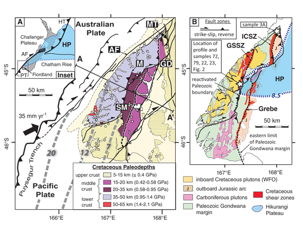
Figure 1.
(A) Map of Fiordland showing the imbrication of Cretaceous lower, middle, and upper crust by Miocene reverse faults. Profile along line of section A–A’ is shown in Figure 3. Paleodepth uncertainties are ±0.1 GPa (±3.7 km). Reconstruction of the subducting Australian Plate at 20, 12, and 7 Ma is from Sutherland et al. (2009). AF—Alpine fault; GD—Glade-Darran fault zone; HP—Hikurangi Plateau; HT—Hikurangi Trench; M—Misty fault; MT—Mt. Thunder fault; SM—Spey-Mica Burn fault zone; PT—Puysegur Trench. (B) Map showing position of two Carboniferous crustal boundaries (black dashed lines). The western boundary coincides with the George Sound shear zone (GSSZ) and SM fault zone. The eastern one coincides with the Grebe and Indecision Creek (ICSZ) shear zones, and Mt. Thunder fault. WFO is Western Fiordland Orthogneiss. Locations of three pseudotachylyte samples (22, 23, 3A) dated at 8–7 Ma shown with white stars. Dashed blue line surrounding light blue region represents high Vp (~8.5 km s−1) eclogite crust at the base of the Hikurangi Plateau at ~100 km depth (after Reyners et al., 2017).