
Page 5 - GSATJanuary2020
P. 5
120˚W 116˚W 112˚W
38˚N
CO COCOO
p plateaula eaat
SNB plateau u 36˚N
SNB BNB
CV
Salin
Salinia
Salinia
Salinia
CC 34˚N
B B
Xenolith locations
B: Big Creek
Cv
Cv
C: Cima Cv
Cc
Cc
Cc: Camp Creek Cc
Cv: Chino Valley C C
D: Dish Hill D D
X: Crystal Knob
Mz SNB - SCB SNB - SCB
Mz
Ea
Early Cz subduction rly Cz subduction
Mz underplated schists
megathrust
megathrust Mz underplated schists
X X
Cratonic/inner passive margin crust
Late Ksubduction Cratonic/inner passive margin crust
Late K subduction
channel boundaries Underplated Farallon mantle lithosphere
channel boundaries
Underplated Farallon mantle lithosphere
Late K normal faults Mz wedge + pC SCML (orange) + Mz arclogite (red)
Late K normal faults
Mz wedge + pC SCML (orange) + Mz arclogite (red)
Upper Mz forearc basin (light) + Jurassic ophiolite (dark)
Inactive retro-arc thrusts
Inactive retro-arc thrusts Upper Mz forearc basin (light) + Jurassic ophiolite (dark)
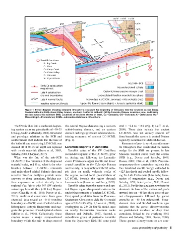
Figure 1. Fence diagram showing idealized lithospheric structure for beginning of Cenozoic time for sections across Sierra
Nevada batholith (SNB)–Great Valley forearc, southern California batholith (SCB)–Colorado Plateau transition zone, and linking
section across the southern SNB. Locations of sections shown on inset. Cz—Cenozoic; CO—Colorado; K—Cretaceous; Mz—
Mesozoic; pC—Precambrian; SCML—subcontinental mantle lithosphere.
The SNB is tilted into a southward deepen- the central Mojave demarcating a western eNd = −6.4 to −13.0 (Fig. 1; Luffi et al.,
ing section spanning paleodepths of ~10–35 schist-bearing domain, and an eastern 2009). These data indicate that ancient
km (e.g., Nadin and Saleeby, 2008). Structural domain lacking significant schist and con- LC-SCML was not entirely sheared off
and petrologic relations in the SCB and taining remnants of ancient LC-SCML from beneath the eastern to central Mojave
southernmost SNB indicate that the base of (Fig. 1). region by Laramide flat-slab subduction.
the batholith and underlying LC-SCML was Remnants of pre- to syn-Laramide man-
sheared off at 30–35 km depth and replaced Laramide Imprints in Xenoliths tle lithosphere that constituted the mantle
with trench materials (Grove et al., 2003; Xenolith suites of the SW Cordillera wedge for the SNB are present in late
Saleeby, 2003; Chapman, 2017). record development of the LC-SCML prior Miocene xenolith suites from the central
What was the fate of the sub-SCB to, during, and following the Laramide SNB (e.g., Ducea and Saleeby, 1998;
LC-SCML? Do remnants of the displaced event. Proterozoic upper mantle and lower Ducea, 2001; Chin et al., 2012). Pressure-
material exist, and if so, what is the rela- crustal xenoliths in the Colorado Plateau temperature-time constraints indicate that
tionship between LC-SCML remnants and vicinity, in conjunction with Nd isoto- this fossilized mantle wedge extended to
and underplated schist? Seismic data and pic data on mafic volcanic rocks of ~125 km depth and cooled rapidly follow-
receiver function analysis provide some the region, record local preservation of ing the Late Cretaceous (Laramide) termi-
answers to these questions, linking sur- LC-SCML beneath the region through nation of magmatism (e.g., Ducea and
face exposures of schist directly to a Laramide time (Livaccari and Perry, 1993). Saleeby, 1998; Saleeby et al., 2003; Chin et
regional flat fabric with NE-SW seismic Xenolith suites from the eastern and cen- al., 2012). Peridotites and garnet websterite
anisotropy beneath thin (~30 km) Mojave tral Mojave region also provide evidence for dominate the base of the section and grade
crust (Cheadle et al., 1986; Porter et al., underlying remnants of ancient LC-SCML. upward into an ~45-km-thick zone of gar-
2011). Additional constraints from geo- First, spinel peridotites from the Pliocene– net clinopyroxenite followed by garnet
chemical data reveal an ~N-S–trending Quaternary Cima cones yield Re-Os model granulite at ~40 km paleodepth. Trace-
boundary at ~116°W, west of which lacks a ages of 1.8–3.4 Ga (Fig. 1; Lee et al., 2001), element data and Sm-Nd isochron ages
lithospheric isotopic fingerprint and sug- overlapping ca. 2.0 Ga Sm-Nd model ages indicate that the garnet clinopyroxenites
gests the presence of underplated schists on nearby Precambrian basement rocks are partial-melt residues, or deep level
(Miller et al., 1996). Collectively, these (Bennett and DePaolo, 1987). Second, a cumulates, linked to the overlying SNB
studies reveal a major compositional subordinate group of peridotite xenoliths (Ducea and Saleeby, 1998; Ducea, 2001).
boundary within the mid- to deep crust of from the Quaternary Dish Hill cone yield These garnet clinopyroxenites are com -
www.geosociety.org/gsatoday 5