
Page 5 - i1052-5173-27-6
P. 5
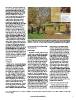
University, at a time before Pokémon Go          Figure 1. Students play “Grand Canyon Expedition: Geologic Time” on the campus quad. Insets (left
was released to the public and became the        to right) are screen shots of the base map with visited locations (orange) and new location (green),
most-downloaded app of all time (GSA             and a screen shot of the Great Unconformity at Blacktail Canyon video, information, and question.
Data Repository1 expanded methodology;
http://idias.usu.edu/; Shelton et al., 2012).    focus), reported in Data Repository Table       interest: interest in the subject residing
For each AR field trip the entirety of           S1 [see footnote 1].                            within the individual prior to taking the
Grand Canyon has been scaled down to a                                                           course; and situational interest: emerging
100 m playing field. The absolute geo-           Interest Index                                  spontaneously in response to exposure in
graphic location of the player does not                                                          the environment) have been validated by
matter; however, because GPS is inte-              All students, including intervention and      the educational psychology field, and have
grated into the application, the module          control groups, completed a demographics        been adapted to suit the geosciences
must be played outside (Fig. 1). The design      survey, geoscience content questions (for       (Pintrich and DeGroot, 1990; Pintrich et
takes advantage of the benefits of games         the student learning component of this          al., 1993; McConnell et al., 2006, 2009;
that provide immersion-in-context,               research, not reported in this paper), and      McConnell and van Der Hoeven Kraft,
rewards for correctness, and immediate           the Geoscience Interest Survey. The evalu-      2011; Harackiewicz et al., 2008; van der
feedback in response to student interac-         ation instrument (the GeoIS) was used at        Hoeven Kraft et al., 2011; Gilbert et al.,
tion. Each module takes ~20 min to play, a       the beginning of the semester and then          2012). The MSLQ has robust reliability
length of time aimed to fit within a wide        after all interventions were complete. The      data with prior studies and has both pre-
range of class types and capture the typical     GeoIS is a modified subset of the Motivated     dictive validity and construct validity in
student’s attention span (Middendorf and         Strategies for Learning Questionnaire           the form of a confirmatory factor analysis.
Kalish, 1996; Milner-Bolotin et al., 2007).      (MSLQ) using the task value component
                                                 subscale and the situational interest sub-        Two main research questions guided the
  This study uses three fundamental geo-         scale; see Data Repository Figure S1 [see       analysis of data: (1) How do these AR field
science topics that can easily be explored       footnote 1]. The MSLQ subset that com-          trips impact student interest in learning
within Grand Canyon as the basis for the         prises the GeoIS evaluates how interesting,     geoscience material? and (2) Which
AR field trips: (1) geologic time, (2) geologic  useful, and important the course content is     demographic and experiential factors
structures, and (3) hydrologic processes.        to the student, and should relate to student    combined with the AR field trips best
For all three AR field trips the stops run       engagement by assessing changes in inter-       predict student motivation and interest to
downstream from Lees Ferry to Lake Mead          est post-intervention (Pintrich et al., 1991;   learn geoscience material?
with photographs, videos, questions, and         Harackiewicz et al., 2008). Motivation self-
interactive touchscreen activities (Table 1).    report subscales used to measure value          DATA ANALYSIS AND RESULTS
As of 2016, these applications (called GCX       beliefs (intrinsic goal orientation, extrinsic
Geologic Time, GCX Geologic Structures,          goal orientation, and task value beliefs)         The data analysis used three steps:
and GCX Hydrologic Cycles) are available         and self-report interest subscales (individual  (1) determining reliability and validity of
on both Android (Google Play) and iOS                                                            the data, and generating a correlation
(App Store) platforms.

METHODS

Participants

  Students at three educational institutions
completed all three AR field trip modules
to provide data for analysis (n = 391).
Students at a fourth school completed
two modules (n = 138), and students at a
fifth school only completed one module
(n = 319). Finally, additional students at
two of the schools (n = 291) acted as con-
trol subjects, completing the pre- and post-
tests and surveys for their regular labs
without participating in the AR field trip
modules. All of the classes utilized in this
study were traditional lecture-based
courses with accompanying labs. The data
set overall represents diverse demograph-
ics and institutions (classed as teaching
focus, teaching-research split, and research

1 GSA Data Repository Item 2017056, expanded description of methodology, statistics, and geoscience interest survey, is online at http://www.geosociety.org/
datarepository/2017/.

                                                 www.geosociety.org/gsatoday                                                                                  5