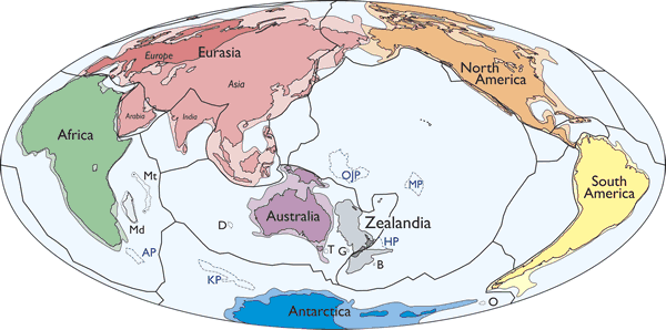
Figure 1.
Simplified map of Earth’s tectonic plates and continents, including Zealandia. Continental shelf areas shown in pale colors. Large igneous province (LIP) submarine plateaus shown by blue dashed lines: AP—Agulhas Plateau; KP—Kerguelen Plateau; OJP—Ontong Java Plateau; MP—Manihiki Plateau; HP—Hikurangi Plateau. Selected microcontinents and continental fragments shown by black dotted lines: Md—Madagascar; Mt—Mauritia; D—Gulden Draak; T—East Tasman; G—Gilbert; B—Bollons; O—South Orkney. Hammer equal area projection.