
The Portland Basin: A (big) river runs through it
Russell C. Evarts, Jim E. O'Connor, Ray E. Wells , Ian P. Madin
In this article
Full Text View
Volume 19 Issue 9 (September 2009)
GSA Today
Article, pp. 4-10 | Abstract | PDF (3.86MB)
The Portland Basin: A (big) river runs through it
Russell C. Evarts1,*, Jim E. O’Connor2, Ray E. Wells1, Ian P. Madin3
1 U.S. Geological Survey, 345 Middlefield Road, Menlo Park, California 94025, USA
2 U.S. Geological Survey, Oregon Water Science Center, 2130 SW 5th Ave., Portland, Oregon 97201, USA
3 Oregon Dept. of Geology and Mineral Industries, 800 NE Oregon Street, Portland, Oregon 97230, USA
[Table: Table of Contents Introduction A Forearc Basin: Geography and … Basin Inception, Basalt Floodin...]
Metropolitan Portland, Oregon, USA, lies within a small Neogene to Holocene basin in the forearc of the Cascadia subduction system. Although the basin owes its existence and structural development to its convergent-margin tectonic setting, the stratigraphic architecture of basin-fill deposits chiefly reflects its physiographic position along the lower reaches of the continental-scale Columbia River system. As a result of this globally unique setting, the basin preserves a complex record of aggradation and incision in response to distant as well as local tectonic, volcanic, and climatic events. Voluminous flood basalts, continental and locally derived sediment and volcanic debris, and catastrophic flood deposits all accumulated in an area influenced by contemporaneous tectonic deformation and variations in regional and local base level.
Manuscript received 15 May 2009; accepted 27 May 2009.
doi: 10.1130/GSATG58A.1
*E-mail:
INTRODUCTION
The Portland Basin is one of several topographic and structural depressions that collectively constitute the Puget-Willamette forearc trough of the Cascadia subduction system (Fig. 1). Bisected by the lowermost reaches of the Columbia River—one of the few major world rivers cutting through an active volcanic arc—and located within a monogenetic volcanic field, the Portland Basin records not only local tectonic and volcanic activity, but also major North American geologic events, including emplacement of huge flood-basalt flows and inundation by colossal glacier-outburst floods. We provide a synopsis of Portland Basin evolution based on recent detailed geologic mapping, light detection and ranging (LiDAR) surveys, potential-field geophysics, and paleomagnetic and geochronologic investigations.
Figure 1
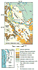
Generalized geology of Portland Basin and vicinity, modified from Blakely et al. (2000). Inset shows location of Portland Basin in forearc trough between Coast Range forearc high and Cascade Range volcanic arc.
A FOREARC BASIN: GEOGRAPHY AND TECTONIC SETTING
The modern 30 × 80 km topographic basin is rectangular and northwest-elongated (Fig. 1) and originated as an early Neogene structure superimposed on the Paleogene strandline. Uplands flanking the basin are underlain by late Eocene and Oligocene subaerial volcanogenic rocks of the Cascade arc to the east and coeval uplifted marine sedimentary strata above accreted oceanic crust to the west. Geologic mapping and subsurface data show the present basin to be a wide, faulted, asymmetric syncline, bounded on the southwest by the Portland Hills, a faulted anticline of Miocene Columbia River Basalt (Fig. 1). The basin is filled with Miocene to Holocene sediments (Fig. 2). Isolated wells (Swanson et al., 1993; Mabey and Madin, 1995) and seismic reflection (Liberty, 2002) and gravity (Morin et al., 2007) data indicate that the floor of the sedimentary basin extends to ~400 m below sea level (bsl) and is deepest along its southwest edge.
Figure 2
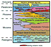
Schematic stratigraphic relations in the Portland Basin. LKT—low-potassium tholeiite.
Seismic activity in the Portland area is diffuse, and basin-margin structures are obscure. Focal mechanisms, well-bore breakouts, and GPS (Werner et al., 1991; Lewis et al., 2003; McCaffrey et al., 2007) indicate that the basin lies within a region of north-south margin-parallel compression related to the rotation and northward transport of an Oregon Coast Range microplate (Wells et al., 1998). Geologic, geophysical, and paleomagnetic data suggest that a dextral shear component of northward motion is accommodated by oblique slip on northwest-striking fault zones (Thomas et al., 1996; Blakely et al., 1995, 2000; Hagstrum et al., 2007). The Portland Basin exhibits some aspects of a pull-apart basin (Beeson et al., 1985, 1989; Yelin and Patton, 1991), but recent mapping and geophysical analysis indicate a more complex, poorly understood transpressional structure.
BASIN INCEPTION, BASALT FLOODING, AND EARLY SEDIMENTATION
The Portland Basin began to form after 20 Ma, probably as a broad syncline parallel to the Portland Hills anticline (Fig. 3A), as indicated by basinward-dipping attitudes of Paleogene strata along the basin margins (Evarts, 2004a, 2004b, 2004c, 2006). This fold developed contemporaneously with uplift of Paleogene strata to form the Coast Range forearc high (Snavely and Wells, 1996; Evarts and Swanson, 1994; McNeill et al., 2000).
Figure 3
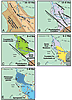
Evolution of the Portland Basin with course of modern Columbia River for reference. (A) Portland Basin initiated as a syncline in Paleogene strata (green). Nascent Portland Hills anticline diverts earliest Grande Ronde Basalt flows to north, but later flows spread west and south. (B) Subsidence continues, with development of complex NW-striking, right-lateral fault zones. Ancestral Columbia River deposits Sandy River Mudstone on broad floodplain. The volcaniclastic Rhododendron Formation encroaches into southern part of the basin. (C) Troutdale Formation conglomerate spreads across basin. (D) Hyaloclastite, generated as low-potassium tholeiite (LKT) flows interact with the ancestral Columbia River, is deposited as a synvolcanic fan (Troutdale Formation hyaloclastic sandstone member) in the eastern Portland Basin. Subsequent incision forms the modern Columbia River Gorge. The Boring Volcanic Field initiated at 2.6 Ma. (E) Outwash gravels deposited by the Columbia River in the north while Cascadian volcaniclastic deposits accumulate in the south. The Columbia River incises these deposits, establishing its present course. Boring Volcanic Field eruptions resume at 1.6 Ma, spreading northward after 1.2 Ma. Late Pleistocene Missoula Floods deposit sediment and sculpt terrain below 120 m asl.
At 16–15 Ma, flood-basalt flows of the Columbia River Basalt Group entered northwestern Oregon via a broad Columbia River valley transecting the Cascade Range (Beeson et al., 1989). The distribution of Grande Ronde Basalt flows delimits a basin between the western Cascade Range and a nascent Portland Hills anticlinal ridge (Fig. 3A) (Beeson et al., 1989). Sparse sub-basalt fluvial sediments (Van Atta and Kelty, 1985; Evarts, 2002, 2004a) attest to the prior existence of the ancestral Columbia River along the synclinal axis. Later Grande Ronde Basalt flows overwhelmed the Portland Hills anticline, but this structure continued to rise and by ca. 14 Ma was established as a permanent barrier that deflected the ancestral Columbia River northward (Beeson et al., 1989; Wilson, 2000).
During the last half of the Miocene, the Columbia River continued to pour sediment into the subsiding Portland Basin, including as much as 200 m of fine-grained fluvial and lacustrine sediments of the lower Sandy River Mudstone (Trimble, 1963) (Figs. 2 and 3B). This formation consists of thin-bedded micaceous and tuffaceous sandstone and siltstone, carbonaceous claystone, lignite, minor pumiceous tuff, and local gravel lenses (Trimble, 1963; Mundorff, 1964; Howard, 2002; Evarts, 2004a, 2004b). Most of this detritus originated in pre-Tertiary terranes east of the volcanic arc. The Sandy River Mudstone records a Columbia River similar in character to the low-gradient modern river. Like today, these beds were probably deposited near sea level, but there is no evidence that the Portland Basin was a marine estuary. Similar sediments beneath the northern Willamette Valley indicate that the basin receiving Columbia River sediments extended southward around the southeastern end of the Portland Hills anticlinal ridge (Yeats et al., 1996).
The paucity of volcanogenic material in these fine-grained beds is consistent with weak volcanic activity in the southern Washington segment of the Cascade arc during this time (Evarts and Swanson, 1994). To the southeast, however, eruptions of andesitic volcanoes in the northern Oregon Cascades fed debris flows and related fluvial deposits of the Rhododendron Formation (Trimble, 1963) into the southernmost part of the basin to construct a thick, northward-sloping volcaniclastic apron (Figs. 2 and 3B).
AN ENERGIZED RIVER
Near the end of the Miocene, the Columbia River transformed into a gravel-bed stream depositing coarse sandstone and conglomerate of the lower Troutdale Formation (Figs. 2 and 4A). A narrow paleocanyon cut into Grande Ronde Basalt flows and Paleogene bedrock east of the Portland Basin contains >200 m of conglomerate (Tolan and Beeson, 1984). This latest Miocene channel entered the eastern Portland Basin north of the modern river (Fig. 3C), building a broad braidplain westward across the basin and burying the lower Sandy River Mudstone with >70 m of gravel. The conglomerate is composed mainly of rounded cobbles and pebbles of Columbia River Basalt, but nearly ubiquitous clasts of quartzite and coarse-grained metamorphic and granitic rocks, as well as interbedded arkosic to quartzose micaceous sands, point to an extrabasinal source in pre-Tertiary terranes of eastern Washington and Idaho. Massive to crudely stratified beds, clast-support, openwork and sand-matrix textures, moderate to good sorting, and clast imbrication indicate deposition by a high-energy braided river. The far-traveled gravel and paucity of locally derived material indicate that the sudden influx of coarse sediment resulted from events far upstream, likely due to deformation and consequent erosion in and around the Columbia Plateau east of the Cascade Range.
Figure 4

Selected deposits in the Portland Basin. (A) Conglomerate and micaceous sandstone in the lower part of the Troutdale Formation. (B) Photomicrograph of hyaloclastic sandstone from the upper part of the Troutdale Formation. (C) Cinder-cone beds on Mount Tabor (203 ± 5 ka). Outcrop is ~6 m high. (D) Pleistocene Columbia River terrace gravel deposits, northern Portland Basin. (E) Missoula flood boulders hindering development, eastern Portland Basin. (F) Sand (light) and silt (dark) couplets deposited by overbank flooding on the late Holocene Columbia River floodplain, northern Portland Basin.
Following deposition of the Troutdale Formation conglomerate, the Columbia River reincised through the thick gravel braidplain and uplifting western Cascade Range, entering the still-subsiding Portland Basin through a canyon south of the present Columbia River Gorge (Tolan and Beeson, 1984). Eventually, the river reverted to a low-gradient, near–sea level stream similar to its earlier character, depositing fine-grained beds of the upper Sandy River Mudstone, which locally contains early Pliocene fossil floras (Treasher, 1942; Chaney, 1944; Trimble, 1963; Tolan and Beeson, 1984).
MAFIC VOLCANISM IN THE CASCADE RANGE AND INFLUX OF HYALOCLASTIC SEDIMENT
At ca. 3.5 Ma, eruption of voluminous low-potassium tholeiite (LKT) flows in the Cascade Range to the east interrupted deposition of fine-grained Columbia River fluvial sediment in the Portland Basin. Some of these lavas entered the Columbia River—or possibly erupted from vents directly beneath the river—generating large quantities of hyaloclastite that flushed downstream, filling the Columbia River canyon within the western Cascade Range and building a large fan where the river entered the Portland Basin (Fig. 3D) (Tolan and Beeson, 1984). These beds crop out extensively in the eastern Portland Basin, where this unit is >100 m thick (Trimble, 1963; Madin, 1994; Evarts and O’Connor, 2007) and pinch out northwestward in the subsurface (Swanson et al., 1993). The crudely stratified coarse sandstone is intercalated with poorly sorted, foreset-bedded conglomerate containing cobbles and boulders of LKT. The sandstones are composed of angular, partially palagonitized sideromelane fragments (Fig. 4B) of LKT (Swanson, 1986). The poor sorting and monolithologic character of many hyaloclastic beds suggest rapid transport over short distances. East of the Portland Basin, the hyaloclastic sediment becomes interbedded with LKT flows with ages of 3.0–3.5 Ma (Conrey et al., 1996a, 1996b; R.J. Fleck, 2008, personal commun.). These lava flows and hyaloclastic deposits completely filled the Columbia River canyon where it passed through the western Cascade Range, resulting in northward diversion of the river and Quaternary incision of the present western Columbia River Gorge (Tolan and Beeson, 1984).
VOLCANOES AND FLOODS: QUATERNARY LANDFORMS AND DEPOSITS
Volcanism and the indirect effects of Quaternary glaciation have formed most of the present topography of the Portland Basin.
Local Mafic Volcanism of the Boring Volcanic Field
The Portland Basin is peppered with isolated hills and hill clusters rising up to 200 m above the surrounding landscape. Many of these hills are monogenetic volcanoes (Treasher, 1942; Allen, 1975) that erupted west of the Cascade arc axis beginning in latest Pliocene time to form the Boring Volcanic Field (Fig. 1) (Conrey et al., 1996b; Evarts et al., 2009). Boring centers consist of cinder cones (Fig. 4C) and associated lava flows, small shields, and lava cones. Like the many small, contemporaneous volcanoes in the arc, Boring lavas are predominantly geochemically diverse basalt and basaltic andesite (Conrey et al., 2003).
Isotopic age determinations (Madin, 1994; Conrey et al., 1996a; Fleck et al., 2002; R.J. Fleck, 2008, personal commun.) show that the earliest Boring eruptions were at 2.6 Ma in the southern part of the Portland Basin (Fig. 3D), but most activity is younger than 1.8 Ma (Fig. 3E); (Evarts et al., 2009) and has continued at a low but constant level throughout the Quaternary.
Effects of Quaternary Glaciation
While glaciers never directly impinged upon the Portland Basin, Quaternary climate change has affected base level regionally and locally, changed the character of sediment transported and deposited within the basin, and led to the colossal Missoula Floods.
Quaternary Terrace Gravels
Episodic influxes of Columbia River sand and gravel into the Portland Basin in latest Pliocene to late Pleistocene time (Figs. 2 and 3E) are recorded by broad fill terraces flanking the present river. These sediments (Fig. 4D) resemble the Miocene Troutdale Formation conglomerates but are more poorly sorted and contain a higher proportion of clasts (including LKT basalt) derived from the Cascade Range. A prominent surface at 140 m above sea level (asl) in the eastern part of the basin may grade to a 75 m asl surface at the northwest margin. A distinctly lower surface (15–20 m asl) is preserved along the northwestern margin of the basin. Drillers’ logs and quarry exposures indicate that these deposits underlie much of the Portland Basin marginal to the present floodplain of the Columbia River, perhaps locally to a depth of 100 m bsl—the approximate elevation of the Columbia River in the Portland Basin at low sea-level stands during major glaciations.
The presence and position of these terrace deposits are somewhat enigmatic, and their ages are poorly constrained. They pre-date the 16,000–12,000 14C yr B.P. Missoula Flood deposits that overlie them, and the higher deposits are overlain by Boring volcanic rocks as young as 575 ka (Evarts, 2006; Evarts and O’Connor, 2007). The coarse textures and sedimentary facies (Fig. 4D) indicate deposition by a large braided river system. The textures are as expected for sediment delivered during glacial episodes, but those would also be times of depressed sea level, with the Columbia River >100 m below its present position, as it was during the last glacial period (Gates, 1994; Baker, 2002). One plausible scenario is that these deposits formed at times of advanced glaciations, when deposition of voluminous outwash from the Lewis River at the north end of the Portland Basin forced upstream Columbia River aggradation (O’Connor and Evarts, 2007). Partly contemporaneous fan and terrace deposits flanking the Sandy and Clackamas rivers along the east and southeast margins of the basin, including the volcaniclastic Springwater Formation (Figs. 2 and 3E) (Trimble, 1963), indicate that volcanism and mountain glaciation in northern Oregon were also contributing sediment near the time of terrace formation.
Missoula Floods
Much of the modern land surface in the Portland Basin below 120 m asl is underlain by silt, sand, and gravel deposited by the cataclysmic late Pleistocene Missoula Floods (Figs. 2 and 4E). These floods occurred when a lobe of the Cordilleran Ice Sheet blocked the Clark Fork River in northwestern Montana, forming Glacial Lake Missoula, a lake 525 m deep at its maximum, with a volume of 2200 km3. The ice-dam ruptured multiple times between 16,000 and 12,000 14C yr B.P., sending floods as large as 107 m3 across eastern Washington, through the Columbia River Gorge, and into the Portland Basin (Bretz, 1925, 1928; Baker, 1973; Waitt, 1980, 1985; Benito and O’Connor, 2003). The largest of these floods entered the Portland Basin with velocities of 35 m3/s and depths approaching 300 m (Benito and O’Connor, 2003). Flow velocity diminished rapidly westward as the floodwaters ponded behind the constricted Columbia River valley at the northwestern basin exit.
First described by Bretz (1928) and now beautifully revealed by high-resolution topographic data, the Missoula floods carved immense channels on the uplands and around Boring volcanic centers, built large bars along the main current threads, and blanketed backwater areas below 100 m asl with silt and sand. The colossal gravel bars are thickest and coarsest in the eastern Portland Basin, where bedload clasts attain diameters exceeding 5 m (Fig. 4E), and in the lee of flow-protruding uplands, where bars are formed of up to 70 m of festoon-bedded boulder sand and gravel. In backwater areas and up tributary valleys, rhythmically layered fine-grained deposits show that at least 40 such floods achieved stages of 35–50 m asl in the Portland Basin and Willamette Valley (Glenn, 1965; O’Connor et al., 2001; James, 2002).
Loess
Massive, micaceous, quartzofeldspathic eolian silt, known as the Portland Hills Silt (Lentz, 1981), blankets most upland surfaces above areas affected by the Missoula Floods but is especially thick on the uplands close to the Columbia River and in the Portland Hills. The Portland Hills Silt contains paleosols that indicate episodic accumulation separated by periods of relative surface stability enabling soil development. The distribution of the loess indicates deposition by easterly winds (Lentz, 1981), which regularly enter the Portland Basin during winter, when atmospheric high pressure in the interior drives easterly airflow down the Columbia River Gorge. Such winds were probably more prevalent during Quaternary glacial ages when high-pressure cells were entrenched over the Cordilleran Ice Sheet.
Holocene Sea-Level Rise and the Modern Columbia River Floodplain
Since the end of the last glacial epoch, sea level has been rising, and the Columbia River has aggraded its channel and floodplain. Borehole data from near the modern mouth of the Columbia River show that river level was 113 m below present sea level ca. 13,000 14C yr B.P. (Baker, 2002). Consistent with this, well records and seismic-reflection profiles in the Portland Basin indicate that 100 m of sand and silt fill a buried late Pleistocene paleochannel below the modern Columbia River floodplain (Fig. 2) (Hoffstetter, 1984; Hartford and McFarland, 1989; Gates, 1994; Madin, 1998; Pratt et al., 2001; Rapp, 2005). The present Columbia River floodplain (Fig. 4F), which caps this aggradational sequence and is everywhere <10 m asl, historically aggraded by overbank deposition and bar accretion, primarily during snowmelt floods that inundated the floodplain each summer before twentieth-century construction of dams and floodplain levees.
Holocene Cascade Range Volcanism
Cascade Range volcanism has affected the Portland Basin throughout the Quaternary. Although Pleistocene deposits contain tephra layers and fluvially reworked volcanogenic materials, it is late Holocene volcanic activity that has left the clearest mark on the present topography. At the eastern margin of the Portland Basin, the Sandy River has served as a conduit for lahars and large quantities of volcaniclastic sand and gravel derived from Mount Hood. At least three lahars reached the Columbia River during the Mount Hood Timberline eruptive period of ca. 1500 14C yr B.P., followed by another pulse of aggradation during the Old Maid eruptive episode ~200 years ago. The Mount Hood lahars and up to 5 m of related aggradation built out the Sandy River delta, pushing the Columbia River 2 km northward (Rapp, 2005). Similarly, Mount St. Helens eruptions have shed lahars and sediment down the Lewis River and into the northern part of the Portland Basin, where extensive bottomlands at the mouth of the Lewis River were formed during the Pine Creek (ca. 2500 14C yr B.P.) and Kalama (ca. 500 14C yr B.P.) eruptive periods at Mount St. Helens (Vogel, 2005). At least one similar but larger episode of Pleistocene aggradation from Mount St. Helens apparently blocked the Columbia River to at least 25 m asl (Evarts, 2002).
CONCLUSIONS
The Portland Basin occupies the globally exceptional situation of a forearc basin bisected by a large continental river—a unique juxtaposition of local and regional geologic processes. Although the convergent margin setting is responsible for the structural development of the Portland Basin and flanking Coast and Cascade Ranges, basin sedimentation is dominated by distant tectonic, volcanic, and environmental events, which introduced a variety of materials into the basin. Quaternary climate change influenced basin sedimentation and erosion by controlling Columbia River base level as well as through the cataclysmic Missoula Floods, which shaped many of the present landforms of the Portland Basin.
ACKNOWLEDGMENTS
This manuscript was improved by reviews by Gary Smith, Stephen Johnston, William McFarland, and William Scott.
REFERENCES CITED
- Allen, J.E., 1975, Volcanoes of the Portland area: Ore Bin, v. 37, p. 145–157.
- Baker, D.L., 2002, Holocene (2–16 ka) sedimentation in the Columbia River estuary [M.S. thesis]: Portland, Oregon, Portland State University, 261 p.
- Baker, V.R., 1973, Paleohydrology and sedimentology of Lake Missoula flooding in eastern Washington: Geological Society of America Special Paper 144, 79 p.
- Beeson, M.H., Fecht, K.R., Reidel, S.P., and Tolan, T.L., 1985, Regional correlations within the Frenchman Springs Member of the Columbia River Basalt Group: New insights into the middle Miocene tectonics of northwestern Oregon: Oregon Geology, v. 47, p. 87–96.
- Beeson, M.H., Tolan, T.L., and Anderson, J.L., 1989, The Columbia River Basalt Group in western Oregon; geologic structures and other factors that controlled flow emplacement patterns, in Reidel, S.P., and Hooper, P.R., eds., Volcanism and tectonism in the Columbia River flood-basalt province: Geologic Society of America Special Paper 239, p. 223–246.
- Benito, G., and O’Connor, J.E., 2003, Number and size of last-glacial Missoula floods in the Columbia River valley between the Pasco Basin, Washington, and Portland, Oregon: Geological Society of America Bulletin, v. 115, p. 624–638, doi: 10.1130/0016-7606(2003)115<0624:?NASOLM>2.0.CO;2.
- Blakely, R.J., Wells, R.E., Yelin, T.S., Madin, I.P., and Beeson, M.H., 1995, Tectonic setting of the Portland-Vancouver area, Oregon and Washington—Constraints from low-altitude aeromagnetic data: Geological Society of America Bulletin, v. 107, p. 1051–1062, doi: 10.1130/0016-7606(1995)107<1051:TSOTPV>2.3.CO;2.
- Blakely, R.J., Wells, R.E., Tolan, T.L., Beeson, M.H., Trehu, A.M., and Liberty, L.M., 2000, New aeromagnetic data reveal large strike-slip(?) faults in the northern Willamette Valley, Oregon: Geological Society of America Bulletin, v. 112, p. 1225–1233, doi: 10.1130/0016-7606?(2000)112<1225:NADRLS>2.3.CO;2.
- Bretz, J.H., 1925, The Spokane flood beyond the Channeled Scablands: The Journal of Geology, v. 33, p. 97–115, 236–259.
- Bretz, J.H., 1928, Bars of the Channeled Scabland: Geological Society of America Bulletin, v. 39, p. 643–702.
- Chaney, R.W., 1944, The Troutdale Flora, in Chaney, R.W., ed., Pliocene floras of California and Oregon: Contributions to Paleontology, Carnegie Institution of Washington Publication 553, p. 323–351.
- Conrey, R.M., Sherrod, D.R., Uto, K., and Uchiumi, S., 1996a, Potassium-?argon ages from Mount Hood area of Cascade Range, northern ?Oregon: Isochron West, no. 63, p. 10–20.
- Conrey, R.M., Uto, K., Uchiumi, S., Beeson, M.H., Madin, I.P., Tolan, T.L., and Swanson, D.A., 1996b, Potassium-argon ages of Boring Lava, northwest Oregon and southwest Washington: Isochron West, no. 63, p. 3–9.
- Conrey, R.M., Leeman, W.P., Streck, M.J., and Evarts, R.C., 2003, The Boring Volcanic Field of the Portland Basin—Diverse primitive mafic magmas erupted in a frontal arc setting: Eos (Transactions, American Geophysical Union), v. 84, p. F1552–F1553.
- Evarts, R.C., 2002, Geologic map of the Deer Island quadrangle, Columbia County, Oregon, and Cowlitz County, Washington: U.S. Geological Survey Miscellaneous Field Studies Map MF-2392, scale: 1:24,000.
- Evarts, R.C., 2004a, Geologic map of the Woodland quadrangle, Clark and Cowlitz Counties, Washington: U.S. Geological Survey Scientific Investigations Map 2827, scale: 1:24,000.
- Evarts, R.C., 2004b, Geologic map of the Ridgefield quadrangle, Clark and Cowlitz Counties, Washington: U.S. Geological Survey Scientific Investigations Map 2844, scale: 1:24,000.
- Evarts, R.C., 2004c, Geologic map of the Saint Helens quadrangle, Columbia County, Oregon, and Clark and Cowlitz Counties, Washington: U.S. Geological Survey Scientific Investigations Map 2834, scale: 1:24,000.
- Evarts, R.C., 2006, Geologic map of the Lacamas Creek quadrangle, Clark County, Washington: U.S. Geological Survey Scientific Investigations Map 2924, scale: 1:24,000.
- Evarts, R.C., and O’Connor, J.E., 2007, Geologic map of the Camas quadrangle, Clark County, Washington and Multnomah County, Oregon: U.S. Geological Survey Scientific Investigations Map 3017, scale: 1:24,000.
- Evarts, R.C., and Swanson, D.A., 1994, Geologic transect across the Tertiary Cascade Range, southern Washington, in Swanson, D.A., and Haugerud, R.A., eds., Geologic field trips in the Pacific Northwest, 1994 Geological Society of America Meeting: Seattle, University of Washington Department of Geological Sciences, v. 2, p. 2H1–2H31.
- Evarts, R.C., Conrey, R.M., Fleck, R.J., and Hagstrum, J.T., 2009, The Boring Volcanic Field of the Portland-Vancouver area, Oregon and Washington: Tectonically anomalous forearc volcanism in an urban setting, in O’Connor, J.E., Dorsey, R.J., and Madin, I.P., eds., Volcanoes to vineyards: Geologic field trips through the dynamic landscape of the pacific northwest: Geological Society of America Field Guide 15, doi: 10.1130/2009.fld015(13).
- Fleck, R.J., Evarts, R.C., Hagstrum, J.T., and Valentine, M.J., 2002, The Boring Volcanic Field of the Portland, Oregon area—Geochronology and neotectonic significance [abs.]: Geological Society of America Abstracts with Programs, v. 34, no. 5, p. 33.
- Gates, E.B., 1994, The Holocene sedimentary framework of the lower Columbia River basin [M.S. thesis]: Portland, Portland State University, 210 p.
- Glenn, J.L., 1965, Late Quaternary sedimentation and geologic history of the north Willamette Valley, Oregon [Ph.D. thesis]: Corvallis, Oregon State University, 231 p.
- Hagstrum, J.T., Wells, R.E., Evarts, R.C., Blakely, R.J., and Beeson, M.H., 2007, Vertical-axis rotations within 15.6–16 Ma Columbia River Basalt flows define a sharp eastern boundary of the Coast Range block in northwestern Oregon: Geological Society of America Abstracts with Programs, v. 39, no. 4, p. 29.
- Hartford, S.V., and McFarland, W.D., 1989, Lithology, thickness, and extent of hydrogeologic units underlying the east Portland area, Oregon: U.S. Geological Survey Water-Resources Investigations Report 88-4110, 23 p.
- Hoffstetter, W.H., 1984, Geology of the Portland Well Field: Oregon Geology, v. 46, p. 63–67.
- Howard, K.A., 2002, Geologic map of the Battle Ground 7.5-minute quadrangle, Clark County, Washington: U.S. Geological Survey Miscellaneous Field Studies Map MF-2395, scale: 1:24,000.
- James, D.H., 2002, Stratigraphy, sedimentology, and geochemistry of Missoula flood rhythmites in the northern Willamette Valley, Oregon [M.S. thesis]: Portland, Portland State University, 100 p.
- Lentz, R.L., 1981, The petrology and stratigraphy of the Portland Hills Silt—A Pacific Northwest loess: Oregon Geology, v. 43, no. 1, p. 3–10.
- Lewis, J.C., Unruh, J.R., and Twiss, R.J., 2003, Seismogenic strain and motion of the Oregon coast block: Geology, v. 31, p. 183–186, doi: 10.1130/0091-7613(2003)031<0183:SSAMOT>2.0.CO;2.
- Liberty, L.M., 2002, The Portland Basin as imaged by a reprocessed industry seismic profile on the Columbia River—Implications for earthquake hazards: Seismological Research Letters, v. 73, no. 2, p. 249.
- Mabey, M.A., and Madin, I.P., 1995, Downhole and seismic cone penetrometer shear-wave velocity measurements for the Portland metropolitan area, 1993 and 1994: Oregon Dept. of Geology and Mineral Industries Open-File Report O-95-7, 69 p.
- Madin, I.P., 1994, Geologic map of the Damascus quadrangle, Clackamas and Multnomah Counties, Oregon: Oregon Dept. of Geology and Mineral Industries Geological Map GMS-60, scale: 1:24,000, with 9-p. pamphlet.
- Madin, I.P., 1998, Earthquake hazard geologic maps of the Portland, Oregon, metropolitan area, in Rogers, A.M., Walsh, T.J., Kockelman, W.J., and Priest, G.R., eds., Assessing earthquake hazards and reducing risk in the Pacific Northwest, v. 2: U.S. Geological Survey Professional Paper 1560, p. 355–370.
- McCaffrey, R., Qamar, A.I., King, R.W., Wells, R.E., Khazaradze, G., Williams, C.A., Stevens, C., Vollick, J.J., and Zwick, P.C., 2007, Fault locking, block rotation and crustal deformation in the Pacific Northwest: Geophysical Journal International, v. 169, p. 1315–1340, doi: 10.1111/j.1365-246X.2007.03371.x.
- McNeill, L.C., Goldfinger, C., Kulm, L.D., and Yeats, R.S., 2000, Tectonics of the Neogene Cascadia forearc basin: Investigations of a deformed late Miocene unconformity: Geological Society of America Bulletin, v. 112, p. 1209–1224, doi: 10.1130/0016-7606(2000)112?<1209:TOTNCF>2.3.CO;2.
- Morin, R.L., Wheeler, K.L., McPhee, D.K., Dinterman, P.A., and Watt, J.T., 2007, Principal facts of gravity data in the northern Willamette Valley and vicinity, northwestern Oregon and southwestern Washington: U.S. Geologic Survey Open-File Report 2007-1058, 6 p.
- Mundorff, M.J., 1964, Geology and ground-water conditions of Clark County, Washington, with a description of a major alluvial aquifer along the Columbia River: U.S. Geologic Survey Water-Supply ?Paper 1600, 268 p., scale: 1:48,000.
- O’Connor, J.E., and Evarts, R.C., 2007, New findings on the Quaternary geologic history of the lower Columbia River corridor: Geological Society of America Abstracts with Programs, v. 39, no. 4, p. 28.
- O’Connor, J.E., Sarna-Wojcicki, A., Wozniak, K.C., Pollette, P.J., and Fleck, R.J., 2001, Origin, extent, and thickness of Quaternary geologic units in the Willamette Valley, Oregon: U.S. Geological Survey Professional Paper 1620, 52 p.
- Pratt, T.L., Odum, J., Stephenson, W., Williams, R., Dadisman, S., Holmes, M., and Haug, B., 2001, Late Pleistocene and Holocene tectonics of the Portland Basin, Oregon and Washington, from high-resolution seismic profiling: Bulletin of the Seismological Society of America, v. 91, p. 637–650, doi: 10.1785/0119990085.
- Rapp, E.K., 2005, The Holocene stratigraphy of the Sandy River delta, Oregon [M.S. thesis]: Portland, Portland State University, 93 p.
- Snavely, P.D., Jr., and Wells, R.E., 1996, Cenozoic evolution of the continental margin of Oregon and Washington, in Rogers, A.M., Walsh, T.J., Kockelman, W.J., and Priest, G.R., eds., Assessing earthquake hazards and reducing risk in the Pacific Northwest: U.S. Geological Survey Professional Paper 1560, p. 161–182.
- Swanson, R.D., 1986, A stratigraphic-geochemical study of the Troutdale Formation and Sandy River Mudstone in the Portland Basin and lower Columbia River Gorge [M.S. thesis]: Portland, Portland State University, 103 p.
- Swanson, R.D., McFarland, W.D., Gonthier, J.B., and Wilkinson, J.M., 1993, A description of hydrogeologic units in the Portland Basin, Oregon and Washington: U.S. Geological Survey Water-Resources Investigations Report 90-4196, 56 p., scale: 1:100,000.
- Thomas, G.C., Crosson, R.S., Carver, D.L., and Yelin, T.S., 1996, The 25 March 1993 Scotts Mills, Oregon, earthquake and aftershock sequence—Spatial distribution, focal mechanisms, and the Mount Angel fault: Seismological Society of America Bulletin, v. 86, p. 925–935.
- Tolan, T.L., and Beeson, M.H., 1984, Intracanyon flows of the Columbia River Basalt group in the lower Columbia River Gorge and their relationship to the Troutdale Formation: Geological Society of America Bulletin, v. 95, p. 463–477, doi: 10.1130/0016-7606(1984)?95<463:IFOTCR>2.0.CO;2.
- Treasher, R.C., 1942, Geologic history of the Portland area: Oregon Dept. of Geology and Mineral Industries Short Paper 7, 17 p.
- Trimble, D.E., 1963, Geology of Portland, Oregon, and adjacent areas: U.S. Geological Survey Bulletin 1119, 119 p., scale: 1:62,500.
- Van Atta, R.O., and Kelty, K.B., 1985, Scappoose Formation, Columbia County, Oregon—New evidence of age and relation to Columbia River Basalt Group: AAPG Bulletin, v. 69, p. 688–698.
- Vogel, M.S., 2005, Quaternary geology of the lower Lewis River Valley, Washington—Influence of volcanogenic sedimentation following Mount St. Helens eruptions [M.S. thesis]: Pullman, Washington State University, 146 p.
- Waitt, R.B., Jr., 1980, About 40 last-glacial Lake Missoula jökulhlaups through southern Washington: The Journal of Geology, v. 88, p. 653–679.
- Waitt, R.B., Jr., 1985, Case for periodic, colossal jökulhlaups from Pleistocene glacial Lake Missoula: Geological Society of America, v. 96, p. 1271–1286, doi: 10.1130/0016-7606(1985)96<1271:CFPCJF>?2.0.CO;2.
- Wells, R.E., Weaver, C.S., and Blakely, R.J., 1998, Fore-arc migration in Cascadia and its neotectonic significance: Geology, v. 26, p. 759–762, doi: 10.1130/0091-7613(1998)026<0759:FAMICA>2.3.CO;2.
- Werner, K.S., Graven, E.P., Berkman, T.A., and Parker, M.J., 1991, Direction of maximum horizontal compression in western Oregon determined by borehole breakouts: Tectonics, v. 10, p. 948–958, doi: 10.1029/90TC01288.
- Wilson, D.C., 2000, Provenance of the Hillsboro Formation—Implications for the structural evolution and fluvial events in the Tualatin Basin, northwest Oregon: Journal of Sedimentary Research, v. 70, p. 117–129.
- Yeats, R.S., Graven, E.P., Werner, K.S., Goldfinger, C., and Popowski, T.A., 1996, Tectonics of the Willamette Valley, Oregon, in Rogers, A.M., Walsh, T.J., Kockelman, W.J., and Priest, G.R., eds., Assessing earthquake hazards and reducing risk in the Pacific Northwest: U.S. Geological Survey Professional Paper 1650, v. 1, p. 183–222.
- Yelin, T.S., and Patton, H.J., 1991, Seismotectonics of the Portland, Oregon, region: Seismological Society of America Bulletin, v. 81, p. 109–130.
