
Full Text View
Volume 19 Issue 12 (December 2009)
GSA Today
![]()
Article, pp. 4-10 | Abstract | PDF (1,335KB)
Enigmatic boulder trains, supraglacial rock avalanches, and the origin of “Darwin's boulders,” Tierra del Fuego
| Table of Contents |
|---|
| Search GoogleScholar for
Search GSA Today |
Charles Darwin considered himself to be a geologist and published extensively on many geologic phenomena. He was intrigued with the distribution of erratic boulders and speculated upon their origins. In his accounts of the voyage of the HMS Beagle,Darwin described crystalline boulders of notable size and abundance near Bahía San Sebastian, south of the Strait of Magellan, Tierra del Fuego. Influenced by Charles Lyells reflections upon slow, vertical movements of crust, submergence, and ice rafting to explain drift, Darwin proposed that the boulders of Bahía San Sebastian were ice-rafted. Benefiting from 170 years of subsequent study of the glacial history of Tierra del Fuego, petrography, and terrestrial cosmogenic nuclide measurements, we revisit the origin of “Darwins Boulders” at Bahía San Sebastian. We suggest that they, as well as another train of boulders to the west, at Bahía Inútil, represent rock falls of Beagle-type granite from the Cordillera Darwin onto glacial ice flowing into the Bahía Inútil–Bahía San Sebastian lobe. These supraglacial rock avalanche deposits were subsequently elongated into boulder trains by glacial strain during transport and then deposited upon moraines. The cosmogenic nuclide exposure dates support the correlation of Andean glaciations with the marine oxygen isotope record and the glacial chronologies recently proposed for Tierra del Fuego.
Received 9 August 2009; accepted 9 September 2009.
doi: 10.1130/GSATG72A.1
*E-mail:
INTRODUCTION
Influenced by Adam Sedgewick and Charles Lyells Principles of Geology (v. 1, 1830), Charles Darwin became established as a geologist as a result of his voyage on the HMS Beagle. In his writings, he portrayed himself so: “I, a geologist, have ill-defined notion of land covered with ocean…” (Darwin notebook M, no. 40, 1838, p. 39–40). Darwin belonged to the Geological Society of London (GSL) and was elected secretary in 1838. He provided us with the first geological map of southern South America. Over his career, he published more than 20 geologic articles, and in 1859, was awarded the Wollaston Medal—the highest honor of the GSL—in recognition of his contributions. In fact, his push to disseminate the geological work, including the three geology volumes of the Beagle voyage, delayed the publication of On the Origin of Species until 1859 (coincidentally when the Wollaston Medal was awarded).
Darwins records as naturalist on the HMS Beagle reveal his curiosity concerning landscape evolution. For instance, his interpretation of atolls “forming as land sunk” and his measurements of raised marine terraces in South America attest to his interest in monitoring landscape change. Darwins thinking was profoundly influenced by Lyells obsession with large-scale, slow, vertical movements of the crust, especially as manifested in his theory of submergence and ice rafting to explain drift. In turn, Lyell profited greatly from Darwins observations, including uplift of the Pacific coast of Chile during the Talcahuano earthquake. Lyell celebrated these observations because they supported his idea of uniformitarianism—that continued small changes, as witnessed in the field, could account for dramatic changes of Earths surface over geologic time.
Here we report another example of Darwins predilection for interpreting landscape anomalies with inductive reasoning. One-hundred-seventy years later, we share his fascination with the gigantic granitic boulders on the Atlantic coast of Tierra del Fuego. Under Lyells influence, Darwin invoked the submergence–ice-rafting hypothesis to explain them, which was further supported by reports of icebergs transporting boulders. His ice-rafting hypothesis is herein superseded by one involving supraglacial transport of rock avalanche debris from one coast of Tierra del Fuego to the other, where they were abandoned upon a coastal till plain. Nevertheless, Darwins request to delay the voyage of the HMS Beagle in order to document the unusual boulders has led to a clearer understanding of Cordillera Darwin glaciodynamics and should serve to encourage geologists to explore unexpected encounters that fall beyond the defined tasks at hand.
DARWINS INTERPRETATION OF TIERRA DEL FUEGO ERRATICS
Darwin was long intrigued by erratic boulders, noting their locations and speculating on their origins in numerous papers (Darwin, 1839a, 1839b, 1839c, 1841a, 1841b, 1845, 1848, 1849, 1855). He dedicated one article (Darwin, 1842) exclusively to South America. The boulders at Bahía San Sebastian were discussed in several papers (Darwin, 1839a, 1842, 1848), and his description (1841a, p. 419) that enticed this investigation reads,
…great boulders of various and peculiar crystalline rocks, which have undoubtedly travelled from the south-west coast, lie scattered over the whole of the eastern part of Tierra del Fuego. One enormous block of syenite near St. Sebastian Bay was barn-shaped, and had a girth of 47 feet.
Darwin consistently attributed erratics to ice rafting (1839a, 1839b, 1839c, 1841, 1842, 1845, 1848, 1849, 1855). On more than one occasion, Darwin made reference to observations by Charles Lyell of how sediment-laden icebergs off the coast of Newfoundland would deposit debris onto the sea floor. Later, Darwin observed calving glaciers in Tierra del Fuego that produced icebergs containing boulders, writing in his second-edition account of the Voyage of the Beagle (1845, p. 234) that “some of the icebergs were loaded with blocks of no inconsiderable size, of granite and other rocks, different from the clay-slate of the surrounding mountains.” Further, in his 1841 paper (1841a, p. 430), Darwin wrote,
As one of the two methods of conveying erratic boulders, namely, that by icebergs from glaciers, is now in action on the South American shores, we are naturally led to conclude, that this was the chief agent in the enormous amount of transportal formerly effected over a more extended area.
Another reason Darwin universally applied the concept of long-distance ice rafting was the report by the crew of the schooner Eliza Scott of an iceberg far out at sea carrying a large erratic block, estimated at 12 ft high by 6 ft wide. In “Note on a rock seen on an iceberg…” (1839b), Darwin elucidated why this sighting was significant:
Every fact on the transportation of fragments of rock by ice is of importance, as throwing light on the problem of “erratic boulders,” which has so long perplexed geologists.
Darwin also deduced from his study of marine invertebrate–bearing, “step-formed” surfaces of eastern South America, and observations of uplift associated with the 20 February 1835 Chilean earthquake, that the east and west coasts of South America had been elevated from beneath the sea. His observations of calving glaciers producing debris-bearing icebergs, sighted great distances from possible sources, combined with his firm belief in land emergence, gave him a mechanism to explain emplacement of erratics, which he inferred were deposited too far from mountains to permit direct glacial deposition.
Darwin applied this assumption to the boulders at Bahía San Sebastian (“Darwins Boulders”). In his account of the Voyage of the Beagle (1845, p. 236), his conviction about ice rafting was strengthened by the shared opinion of other geologists:
Few geologists now doubt that those erratic boulders which lie near lofty mountains have been pushed forward by the glaciers themselves, and that those distant from mountains, and embedded in subaqueous deposits, have been conveyed thither either on ice-bergs or frozen in coast-ice.
To Darwin, ice rafting was the only model to explain the erratic boulders of Tierra del Fuego because he found no other evidence for glaciation of the Atlantic coast. In “On the distribution of erratic boulders…” (1841b, p. 430), Darwin stated,
The boulders… are strewed on land, which certainly has been modelled by the action of the sea… this little inclination of the surface, with the absence of mounds or ridges on it, and the angularity of the fragments, are opposed to the notion that the blocks have been pushed to this great distance by glaciers. Hence I conclude… that the boulders were transported by floating ice.
REINTERPRETATION OF ORIGIN OF THE DISTAL TIERRA DEL FUEGO ERRATICS
Figure 1 depicts the Cordillera Darwin, the Strait of Magellan, and the location of the two boulder trains discussed in this paper. “Darwins boulders” are located in the surf at Bahía San Sebastian (Fig. 2A) and on the elevated till plain (Fig. 2B) above a 20 m sea cliff at Punta Sinaí on the Atlantic coast of Tierra del Fuego. They consist of an isolated train of ~500 huge, angular, variably weathered boulders, all of which are medium-grained hornblende granodiorites. Outside of the train, large boulders are rare. The boulders lie on the terminal moraine of the Daniglacial advance of Caldenius (1932) or Rio Cullen Drift of Meglioli (1992), which is bracketed from older than 0.36 m.y. to younger than 1.07 m.y. (Meglioli, 1992; Rabassa et al., 2000; Kaplan et al., 2007).
|
Digital elevation model of the Strait of Magellan region showing location of the erratic boulder trains: a—Bahía Inútil (BI); n—Bahía San Sebastian (BSS). See Figure 5 for detailed maps. The outer limits of four glacial drifts according to Meglioli (1992) are depicted by colored lines. CD—Cordillera Darwin. Shades within Cordillera Darwin depict the Beagle Granite (red), Darwin Granite (orange), and glacier ice fields (white). |
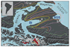 Figure 1
|
Darwins boulders (A) in the surf of the Atlantic Ocean and (B) upon till plains. |
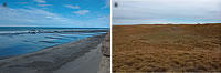 Figure 2
Meglioli (1992) described a second train of gigantic boulders at the head of Bahía Inútil on the western coast of Grande Isle. Darwin was apparently unaware of the existence of the Bahía Inútil boulder train, which interestingly also consists of an isolated group of about 1000 huge, angular, granodioritic boulders. They lie upon the terminal moraine of the Finiglacial advance of Caldenius (1932) or the Bahía Inútil Drift of Meglioli (1992).
Of the three plausible mechanisms for emplacement of these distal erratics—iceberg rafting, stream-ice rafting, or direct deposition from glaciers—we support the latter. Overwhelming evidence for complete glaciation of Tierra del Fuego, from coast to coast, has been unchallenged for almost a century. It is unlikely that stream ice could have transported such large boulders over hundreds of kilometers while maintaining such a tight distribution, and there is no evidence of a capable fluvial environment in the immediate vicinity of either boulder train. On the basis of boulder size, angularity, lithology, and isolation, Meglioli (1992) proposed that the boulders originated as rock avalanches that were transported supraglacially, and Coronato et al. (1999) and McCulloch et al. (2005a) concurred. We supplement the observations that led to this interpretation and propose the bedrock source and timing of deposition of both boulder trains.
Multiple lines of evidence support a rock avalanche–supraglacial transport interpretation for the boulder trains. The evidence includes the (1) great size, (2) angularity, (3) monolithologic composition, and (4) surficial positioning of the boulders, as well as the (5) restricted areal extents, (6) orientations, and (7) locations of the boulder trains on left lateral moraines (looking upstream) of the Bahía Inútil–Bahía San Sebastian ice lobe.
The maximum diameter of the majority of boulders in both trains ranges from 1 m to 16 m, but the size distribution is skewed toward the larger. While glaciers and icebergs can carry large boulders, it would be unlikely for iceberg rafting or subglacial processes to transport such clusters of numerous, extremely large boulders. It is well known, however, that landslides from competent, jointed rocks produce large boulders, which can be supraglacially transported the entire lengths of glaciers.
Almost all of the boulders are sharply angular and show no sign of subglacial abrasion (Fig. 3). The sides of many boulders are roughly planar, suggesting that some surfaces may be original fracture planes. Their angularity and lack of curved faces are indicative of rockfall and supraglacial—not subglacial—transport, and although transport by icebergs could also yield far-traveled angular boulders, we have essentially eliminated this interpretation.
|
Darwins boulders are distinctively angular, lacking evidence for glacial abrasion. |
 Figure 3
Both boulder fields have a limited areal extent, and boulders >1 m in diameter beyond the fringe are rare. Ice rafting would be unlikely to produce concentrations of 500–1000 boulders in the restricted areas occupied by these boulder trains. The boulder trains are not situated in steep-sided valleys, where currents might have concentrated icebergs.
The glacier lobes that extended eastward across Tierra del Fuego had accumulation zones in the Cordillera Darwin. Owing to a complex geological history, the cordillera comprises a wide range of lithologies, including arc volcanics, I- and S-type granitoids, sediments, metasediments, and high-grade metamorphic rocks. Subglacial tills deposited near the termini of the last (Bahía Inútil) and pre-ultimate (Bahía San Sebastian) glaciations are characterized by a wide range of lithologies; however, the erratics in both boulder fields are monolithological, essentially identical, hornblende granites, possessing a coarse tabular jointing pattern. On the basis of petrography and glacial reconstructions, the most likely origin of the erratics is the Beagle Granite in the Cordillera Darwin (Fig. 1) (Nelson et al., 1980). The singular composition of the erratics indicates that subglacial processes, which would commingle all lithologies present throughout the glaciated basin, were unlikely, and instead supports a supraglacial origin by rock avalanche from a subcatchment incising the Beagle Granite.
Careful examination of coastal (Fig. 4A) and stream exposures (Fig. 4B) demonstrates that the boulders lie on or within the upper 2 m of the underlying till units, indicating that the boulders were delivered to the surface of the glacier and subsequently deposited on top of the glacial drift in the last phases of glaciation (Bahía Inútil) or during the initial phase of deglaciation (Bahía San Sebastian). The geometries of both boulder trains were determined by GPS mapping of large boulders. At Bahía San Sebastian, we mapped all boulders larger than 3 m using real-time differential corrected GPS (horizontal precision, ±0.1 m), and at Bahía Inútil, we mapped long and short axes of the train with a Garmin® handheld GPS (horizontal precision, ±5.0 m). The Bahía Inútil boulder train forms an east-west ellipse (Fig. 5A). Similarly, with the exclusion of a small number of “outliers” to the north of the main concentration at Bahía San Sebastian, the train forms an east-west oriented ellipse that has a deflection (Fig. 5B), which we believe relates to deformation of the underlying ice near the lobe terminus prior to deposition.
|
Darwins boulders, which are exposed in (A) sea cliffs and (B) stream valley cuts, lie upon the moraine surface (<2 m depth) and not within tills. |
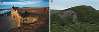 Figure 4
|
Boulders at (A) Bahía Inútil and (B) Bahía San Sebastian (Darwins boulders) exist as trains whose distributions support emplacement through supraglacial transport and deposition. |
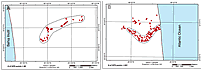 Figure 5
In each train, boulders were deposited atop an extended section of the lateral, verging-on-end moraine. This pattern is fully consistent with the glaciological expectation for transport of supraglacial boulders from a debris fall. End moraines form only in the ablation zone (e.g., Denton et al., 2005), demonstrating that a component of ice-flow velocity was toward the moraine. Because the moraine is longer than the ice-lobe width at its upglacier end, flowlines must diverge toward the moraine, spreading any supraglacial materials along it. Such spreading may be enhanced by additional supraglacial processes of mass transport across the surface of the glacier (e.g., Anderson, 2000; Kowalczuk et al., 2002; Vacco, 2009). Thus, it appears that boulders were carried atop a glacier onto a tongue that had deposited a moraine, and then the boulders were dropped upon the moraine as flow balanced melting. Divergence of flowlines in the tongue spread the boulders along the moraine, probably enhanced by supraglacial mass-transport processes.
Darwin incorrectly interpreted the glacial drift at Bahía San Sebastian as “subaquatic” sediments, based on its proximity to the coast, the distance from any then-known glaciated region (the Andes), the fine-grained nature of the paleosol, and the lack of large boulders within the sediment (the soft Tertiary rocks of the Tierra del Fuegan lowlands do not produce boulders). Although Darwin initially considered the possibility that glaciers could have extended from the Cordillera Darwin, he ruled it out on the basis of such vast distance. In fact, the boulder trains at Bahía San Sebastian and Bahía Inútil lie on moraine crests, albeit the former is older and more subdued. The mapping by Caldenius a century later (1932) would have made the eastward extent of the glaciers evident to Darwin.
Since Caldenius surficial mapping of the Andes (1932), many studies have increased our knowledge of the glacial dynamics of Tierra del Fuego. Meglioli (1992) conducted the most recent detailed glacial sediment mapping throughout all of Tierra del Fuego and southern Patagonia, relying on morphology, stratigraphy, geochronology (his and others), weathering rind development, and pedogenesis. The ages of the pre-ultimate glacial drifts were not well established due to the limited number of 40Ar/39Ar datable volcanic tuff layers interstratified within the tills, and correlations of drifts of five different lobes were based mostly upon relative position. Numerical modeling of the last glacial maximum (Bahía Inútil Lobe; Jackofsky, 2000), constrained by gradients of the lateral and interlobate moraines, provided a means of establishing the position of the paleo-equilibrium line altitude for the eastern Cordillera Darwin, and ice sheet models have provided a better constraint on the advance and retreat of the Patagonian Ice Fields and adjacent regions.
In the past decade, significant attention has been placed on the chronology of the ultimate and pre-ultimate drifts using terrestrial cosmogenic nuclides (TCN). Significant contributions to knowledge of the glacial history have been advanced by Kaplan et al. (2007, 2008), Glasser et al. (2008), and Rabassa (2008), who used combinations of radiocarbon (mostly on peat and lacustrine organics and marine macrofossils) and TCN exposure ages on boulders to date the ultimate and pre-ultimate glaciations. To this foundation, we add the following TCN ages: (i) nine ages on the terminal moraine of the ultimate glaciation of the Bahía Inútil lobe; (ii) four ages on a recessional moraine of the same lobe, but at an elevation below a post-glacial lake (McCulloch et al., 2005b), suggesting that the ages reflect the time of glacial lake drainage; (iii) nine ages on the Bahía San Sebastian boulder train that reproduce problematic exposure ages reported by Kaplan et al. (2007) that were considered too young for the stratigraphic position of the moraine according to previous maps and that are accordingly interpreted to be evidence of rapid exhumation of the drift; and (iv) other ages to constrain the timing of the penultimate glaciation, which was tentatively correlated to marine oxygen isotope stage 6 (OIS-6) glaciation (Meglioli, 1992). Unlike the areas to the north, these TCN dates indicate a significant OIS-4 ice expansion in southern Patagonia and Tierra del Fuego, which is consistent with ice extents in other parts of the mid-latitude southern hemisphere (e.g. Barrows et al., 2001), where the OIS-4 paleo-margin extends beyond the last glacial maximum. Table 1 lists these data; details of the chemistry, analysis, and ages are provided in the GSA Data Repository 1.
| 1GSA Supplemental Data item 2009287, summary of terrestrial cosmogenic nuclide ages for boulders of Bahía Inútil–Bahía San Sebastian ice lobe, with discussion, is available at www.geosociety.org/pubs/ft2009.htm; copies can also be obtained by e-mail to . |
Overall, our new TCN exposure ages generally confirm earlier work of Kaplan et al. (2007, 2008) and McCulloch et al. (2005b) in documenting a rich, but sometimes puzzling, glacial history in the vicinity of Darwins boulders and the Bahía Inútil boulder train. Excluding outliers, which suggest either inheritance or shielding, our Bahía Inútil dates average 22.2 + 0.9 k.y., while our Bahía San Sebastian dates reveal anomalously young ages (74.4 to 38.1 k.y.) for moraines previously interpreted to be ~1 m.y., thus requiring significant reworking. The combined data set is most consistent with a last glacial maximum age for the deposition of the Bahía Inútil boulder train, and an older age for deposition of Darwins boulders (likely OIS-6 or older).
CONCLUSION
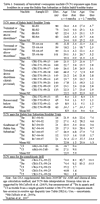 Table 1 Table 1 |
On the voyage of the HMS Beagle, Charles Darwin was struck by the observation of numerous large boulders near Bahía San Sebastian in Tierra del Fuego. In the context of field observations and the preponderant thinking of the day, he interpreted their occurrence as resulting from ice rafting of boulders entrained into icebergs. In his view, emergence of the coastline by vertical uplift then lodged the boulders into their current locations. Darwin and his contemporaries, however, did not recognize the now well-established field evidence for the eastward extent of Andean glaciers that flowed through the Strait of Magellan and the Bahía Inútil–Bahía San Sebastian lobes to the Atlantic Ocean. In light of the accumulated evidence since Darwins time, including our observations, we maintain that the boulder trains of Bahía San Sebastian and Bahía Inútil are the vestiges of Andean rock avalanches, transported supraglacially, and spread by ice flow into linear trains upon moraines. We utilized terrestrial cosmogenic nuclide techniques to date the exposure age of the boulders, constraining the ages of the land surfaces upon which they lie, and placing them into the record of Andean glaciations.
In June of 1833, Charles Darwin delayed the progress of the HMS Beagle to better observe the boulders at Bahía San Sebastian, and in doing so, prompted the eventual satisfactory explanation for their existence. While our interpretations, after nearly two centuries of continuing field mapping and sophisticated material analyses, have revealed inaccuracies in Darwins geologic thoughts about the boulders, we revere his exquisite, detailed recordings of natural occurrences, as well as his pursuit of rational explanations based upon observable phenomena. “Darwins Boulders” are not ice-rafted blocks, but rather glacially transported detritus of alpine avalanches; yet, his accounts of them beckoned us to reexamine the deposits, thus reinforcing his intent to explain landscapes within the constraints of physical evidence.
ACKNOWLEDGMENTS
We thank the Braun family and Charlie Mann of Estancia Sara, as well as the Murchison family of Tres Hermanos estancia, for access to boulder-strewn lands. Oscar Martinez and Curt Sorenson graciously accompanied us on some of the field work. Katherine Chapman, Marcy Davis, and Jack Livingston assisted with cartography. Thanks also to Guang Yang (Dalhousie) and Terry Thomas (New Mexico Institute of Mining and Technology) for the chemical preparation of certain 10Be and 36Cl targets, and Bob Finkel (Lawrence Livermore National Laboratory) and Marc Caffee (PRIME Lab) for high-quality accelerator mass spectrometry analyses. Our manuscript benefited from insightful comments of Robert Dott, at a nascent stage, and Norm Catto, when nearing completion. Portions of the research were supported by NSF Grant EAR-9905341 to J.C. Gosse.
REFERENCES CITED
- Anderson, R.S., 2000, A model of ablation-dominated medial moraines and the generation of debris-mantled glacier snouts: Journal of Glaciology, v. 46, no. 154, p. 459–469, doi: 10.3189/172756500781833025.
- Barrows, T.T., Stone, J.O., Fifield, L.K., and Cresswell, R.G., 2001, Late Pleistocene glaciation of the Kosciuszko Massif, Snowy Mountains, Australia: Quaternary Research, v. 55, no. 2, p. 179–189, doi: 10.1006/qres.2001.2216.
- Caldenius, C.G., 1932, Las glaciaciones Cuaternarias en la Patagonia and Tierra del Fuego: Geografiska Annaler, v. 14, p. 1–164, doi: 10.2307/519583.
- Coronato, A., Roig, C., Rabassa, J., and Meglioli, A., 1999, Erratic boulder field of pre-Illinoian age at Punta Sinaí, Tierra del Fuego, southernmost South America: XV INQUA International Congress, Durham, South Africa, p. 47–48.
- Darwin, C.R., 1838, Notebook M: Metaphysics and expression.
- Darwin, C.R., 1839a, Narrative of the surveying voyages of His Majestys Ships Adventure and Beagle between the years 1826 and 1836, describing their examination of the southern shores of South America, and the Beagles circumnavigation of the globe. Journal and remarks. 1832–1836: London, Henry Colburn, 619 p.
- Darwin, C.R., 1839b, Note on a rock seen on an iceberg in 61° south latitude: Journal of the Royal Geographical Society of London, v. 9, March, p. 528–529, doi: 10.2307/1797747.
- Darwin, C.R., 1839c, Observations on the parallel roads of Glen Roy, and of other parts of Lochaber in Scotland, with an attempt to prove that they are of marine origin [Read 7 February]: Philosophical Transactions of the Royal Society 129, p. 39–81, 2 plates, 4 text figures.
- Darwin, C.R., 1841a, On the distribution of the erratic boulders and on the contemporaneous unstratified deposits of South America [Read 14 April 1841]: Transactions of the Geological Society Part 1, 3, p. 415–431.
- Darwin, C.R., 1841b, On the distribution of the erratic boulders and on the contemporaneous unstratified deposits of South America [Read 5 May]: Proceedings of the Geological Society of London Part 2, 3, p. 425–430.
- Darwin, C.R., 1842, Notes on the effects produced by the ancient glaciers of Caernarvonshire, and on the boulders transported by floating ice: The London, Edinburgh and Dublin Philosophical Magazine, v. 21, September, p. 180–188.
- Darwin, C.R., 1845, [The Voyage of the Beagle] Journal of researches into the natural history and geology of the countries visited during the voyage of H.M.S. Beagle round the world, under the Command of Capt. Fitz Roy, R.N., second edition: London, John Murray, 485 p.
- Darwin, C.R., 1846, Geological observations on South America. Being the third part of the geology of the voyage of the Beagle, under the command of Capt. Fitzroy, R.N., during the years 1832 to 1836: London, Smith Elder and Co., 320 p.
- Darwin, C.R., 1848, On the transportal of erratic boulders from a lower to a higher level: Quarterly Journal of the Geological Society of London, v. 4, p. 315–323.
- Darwin, C.R., 1849, [Letter on floating ice], in Murchison, R.I., On the distribution of the superficial detritus of the Alps, as compared with that of Northern Europe: Proceedings of the Geological Society of London, v. 4, Part 1, p. 65–69.
- Darwin, C.R., 1855, On the power of icebergs to make rectilinear uniformly directed grooves across a submarine undulatory surface: The London, Edinburgh and Dublin Philosophical Magazine, v. 10, August, p. 96–98.
- Darwin, C.R., 1859, On the Origin of Species: London, John Murray.
- Denton, G.H., Alley, R.B., Comer, G.C., and Broeker, W.S., 2005, The role of seasonality in abrupt climate change: Quaternary Science Reviews, v. 24, p. 1159–1182, doi: 10.1016/j.quascirev.2004.12.002.
- Glasser, N.F., Jansson, K.N., Harrison, S., and Kleman, J., 2008, The glacial geomorphology and Pleistocene history of South America between 38 degrees S and 56 degrees S: Quaternary Science Reviews, v. 27, no. 3–4, p. 365–390, doi: 10.1016/j.quascirev.2007.11.011.
- Jackofsky, D.S., 2000, Quaternary glacial chronology and climate dynamics in Tierra del Fuego, Chile, and at Lago Nahuel Huapi, Argentina [M.Sc. Thesis]: Lawrence, Kansas, The University of Kansas, 187 p.
- Kaplan, M.R., Coronato, A., Hulton, N.R.J., Rabassa, J.O., Kubik, P.W., and Freeman, S.P.H.T., 2007, Cosmogenic nuclide measurements in southernmost South America and implications for landscape change: Geomorphology, v. 87, p. 284–301, doi: 10.1016/j.geomorph.2006.10.005.
- Kaplan, M.R., Fogwill, C.J., Sugden, D.E., Hulton, N.R.J., Kubic, P.W., and Freeman, S.P.H.T., 2008, Southern Patagonian glacial chronology for the Last Glacial Period and implications for Southern Ocean climate: Quaternary Science Reviews, v. 27, no. 3-4, p. 284–294, doi: 10.1016/j.quascirev.2007.09.013.
- Kowalczuk, R., Strasser, J.C., Evenson, E.B., Burkhart, P., Ensminger, S.L., and Lawson, D., 2002, Rotation, translation, and vertical displacement of supraglacial clasts during summer ablation, Matanuska Glacier, Chugach Mountains, Alaska: Geological Society of America Abstracts with Programs, v. 34, no. 2, p. 84.
- Lyell, C., 1830, Principles of Geology, v. I–III: London, John Murray.
- McCulloch, R.D., Fogwill, C.J., Sugden, D.E., Bentley, M.J., and Kubik, P.W., 2005a, Chronology of the last glaciation in central Strait of Magellan and Bahía Inútil, southernmost South America: Geografiska Annaler, v. 87, p. 289–312, doi: 10.1111/j.0435-3676.2005.00260.x.
- McCulloch, R.D., Bentley, M.J., Tipping, R.M., and Clapperton, C.M., 2005b, Evidence for late-glacial ice dammed lakes in the central Strait of Magellan and Bahía Inútil, Southernmost South America: Geografiska Annaler, v. 87, p. 335–362, doi: 10.1111/j.0435-3676.2005.00262.x.
- Meglioli, A., 1992, Glacial geology and chronology of southernmost Patagonia and Tierra del Fuego, Argentina and Chile [Ph.D. thesis]: Bethlehem, Pennsylvania, Lehigh University, 330 p.
- Nelson, E.P., Dalziel, I.W.D., and Milnes, A.G., 1980, Structural geology of the Cordillera Darwin; collisional-style orogenesis in the southernmost Chilean Andes: Eclogae Geologicae Helvetiae, v. 73, p. 727–751.
- Rabassa, J., 2008, Late Cenozoic glaciations of Patagonia and Tierra del Fuego: Developments in Quaternary Science, v. 11, p. 151–204.
- Rabassa, J., Coronato, A., Bujalesky, G., Roig, C., Salemme, M., Meglioli, A., Heuser, C., Gordillo, S., Borromei, A., and Quatrocchio, M.J., 2000, Quaternary of Tierra del Fuego, southernmost South America: an updated review: Quaternary International, v. 68–71, p. 217–240, doi: 10.1016/S1040-6182(00)00046-X.
- Vacco, D.A., 2009, Modeling of glacial response to climate changes, including moraine deposition and stagnation events [Ph.D. thesis]: University Park, Pennsylvania, Pennsylvania State University, 101 p.