Introduction
There has been a +100-year debate over depth of deposition interpretations for fine-grained,
organic-rich, upper Devonian–lower Carboniferous stratigraphic units in North America (Conant and
Swanson, 1961; Ettensohn and Barron, 1981; McCollum, 1988), and this debate has accelerated in recent
years. The upper Devonian–lower Carboniferous debate is part of a larger worldwide discussion on the
origin of fine-grained, organic-rich stratigraphic units, as represented by session #144 at GSA Connects
2021, titled “Broken paradigms: Shallow-water deposition of organic-rich facies through Earth history”
(Landing et al., 2021). Regional stratigraphic relationships that define shallow-water organic-rich
depositional systems have recently been proposed for Devonian black shales in New York and suggested as
a worldwide model for similar black shale depositional systems (Smith et al., 2019). Key shallow-water
indications include onlap onto subaerial unconformities and the absence of a base-clinoform setting.
However, the regional stratigraphic relationships for these black shales remain debated, and additional
support data from comparable black shale stratigraphic systems is required to further define
shallow-water relationships.
Research on upper Devonian–lower Carboniferous black shale units in the Bakken Formation in the North
Dakota portion (Fig. 1) of the Williston basin illustrates the shallow-water versus deep-water debate
(see review in Petty, 2019a), with 66% of studies (61 out of 93) supporting deep-water Bakken deposition
versus 34% of studies (32 out of 93) supporting shallow-water Bakken deposition. The debate continues,
with Hart and Hofmann (2020) and Egenhoff and Fishman (2020) advocating for deep-water Bakken black
shale deposition and Petty (2019a, 2021) advocating for shallow-water Bakken black shale deposition.
Although paleontology, geochemistry, and worldwide-event studies contribute to this discussion, the
essence of the argument is a sedimentology versus stratigraphy debate, with conventional sedimentology
interpretations (e.g., fine grain size, clay content, laminations) suggesting deep-water deposition
while stratigraphic observations (e.g., onlap onto subaerial unconformity and lack of
landward-equivalent shallow-water strata) indicate shallow-water deposition. Recent studies suggest that
sedimentology attributes are not unequivocal indicators of deep-water mud deposition (Schieber, 2016);
thus, the stratigraphic geometry may be the ultimate arbitrator.
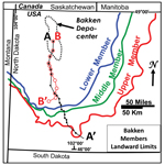 Figure
1
Figure
1
Landward limits for Bakken Formation members, with cross section locations.
Although the Bakken Formation has been intensely studied, overlying stratigraphic units have received
less attention. The term “false Bakken” has been applied to lower Lodgepole stratigraphic units or
lithologies that superficially resemble organic-rich shale units in the underlying Bakken Formation.
Most “false Bakken” designations refer to the basinal facies of the lower Virden subinterval, which lies
a few meters above the top-Bakken in the basin-center, and this unit will be the focus of the Lodgepole
study. To date, all studies (seven total) that offer an opinion on the origin of the organic-rich facies
of the lower Virden conclude that it formed in a deep-water setting. As discussed below, this unit
displays a dramatically different stratigraphic geometry from the Bakken Formation, and this contrast
may offer evidence in the deep-water versus shallow-water debate.
Stratigraphic Setting
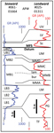
The Madison 2nd-order sequence within the Williston basin was defined by Petty (2006), who placed the
Bakken Formation in the transgressive systems tract and the Lodgepole Formation in the highstand systems
tract (Fig. 2). Bakken strata lie on the Acadian unconformity (Fig. 2), which is characterized by
sub-unconformity weathering near the basin-center (Bottjer et al., 2011) and extensive stratal
truncation with deep sub-unconformity, paleokarst diagenesis in basin-margin areas (Petty, 2017, 2019a).
The lower, middle, and upper members of the Bakken Formation display a regional onlap pattern defined by
younger stratal units extending progressively farther landward than underlying stratal units (Meissner,
1978; Webster, 1984). Onlap is best displayed on the eastern to southern basin-flank (Fig. 1) where
stable cratonic conditions persisted. Bakken deposition was followed by a major sea-level rise that
formed the 2nd-order maximum flooding surface (Fig. 2) and flooded western North America, resulting in
widespread epeiric conditions during early highstand deposition of lower Lodgepole sediments (Petty,
2019a, 2019b).
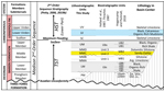 Figure
2
Figure
2
Stratigraphic column for the Bakken Formation and basal portion of the Lodgepole Formation.
Arg.—argillaceous; Dol.—dolostone; Ls.—limestone; Sst.—sandstone; Sltst.—siltstone; HST—highstand
systems tract; TST—transgressive systems tract.
Lithostratigraphic Units
Bakken lithostratigraphic descriptions are from wells in Figures 3 and 4, with mineralogy from Petty
(2019a, table 1). The formation and member nomenclature of LeFever et al. (2011) is used for Bakken
Formation units (Fig. 2). The gamma-ray character for lithostratigraphic units is illustrated with type
logs in Figure 5. Pronghorn Member sediments were deposited on the Acadian unconformity in local
depocenters with compositions reflecting erosion from local sources. Above the Pronghorn, all Bakken
lithostratigraphic units can be correlated from the basin-center to the landward Bakken limit (Fig. 3).
The Lower Member consists dominantly of black, faintly laminated to massive, organic-rich (7%–25% TOC
from LeFever, 2008), high gamma-ray (250–1200 American Petroleum Institute [API] units), argillaceous
(35% clay minerals), pyritic (7%), low-calcite (1%), silty shale. Cross section B–B′ (Fig. 4) shows a
regional north-south correlation of the LB1, LB2, and LB3 subunits within the shale (see biostratigraphy
below). This illustrates landward, intra-shale onlap with younger units extending progressively farther
landward. The Middle Member A (MMA) lithostratigraphic unit consists of silty, burrowed, argillaceous
limestone. The Middle Member B (MMB) lithostratigraphic unit consists of two facies: a lower bioturbated
siltstone facies (MMBbur), and an upper laminated siltstone facies (MMBlam). The Middle Member C (MMC)
lithostratigraphic unit is defined by a low gamma-ray response (Fig. 5) that represents the lowest clay
content (4%) within the Bakken Formation. The presence of oolitic grainstone, skeletal-oolitic
grainstone, sandy-oolitic grainstone, sandstone, and prominent cross stratification makes the MMC the
most distinctive Middle Member unit. The Middle Member D (MMD) lithostratigraphic unit consists of
argillaceous, dolomitic siltstone. The Upper Member consists dominantly of black, faintly laminated to
massive, organic-rich (2%–26% TOC from LeFever, 2008), high gamma-ray (150–1100 API units), argillaceous
(30% clay minerals), pyritic (6%), low-calcite (2%), silty shale that displays a layer-cake geometry
regionally (Fig. 3).
 Figure
3
Figure
3
Cross section A–A′ showing correlation of Bakken lithostratigraphic units shown in Figure 2. Cross
section location in Figure 1. GR—gamma ray; MFS—maximum flooding surface.
 Figure
4
Figure
4
Cross section B–B′ shows lithostratigraphic-biostratigraphic-chemostratigraphic correlations for the
Lower Member of the Bakken Formation for two seaward wells (from Hogancamp and Pocknall, 2018, fig. 5),
and gamma-ray correlations for landward wells. Cross section location in Figure 1. API—American
Petroleum Institute.
 Figure
5
Figure
5
Type logs with gamma-ray character for lithostratigraphic units of this paper (right) and Bakken
biostratigraphic units (left) of Hogancamp and Pocknall (2018, fig. 5). Logs represent the most-seaward
and most-landward cored wells in Figure 3. Note that logs have different vertical scales (meters) and
horizontal scales (API units). API—American Petroleum Institute.
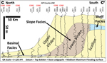
Lodgepole lithostratigraphic descriptions are from locations in Figures 6 and 7. Log-defined units
described in Manitoba by Stanton (1958) and carried through North Dakota by Grover (1996) are used
within the Lodgepole Formation. The lower Virden subinterval is defined by a higher gamma-ray response
than the underlying Scallion and overlying upper Virden subintervals (Fig. 6). Grover (1996) defined a
clinoform geometry that was correlated throughout North Dakota where a thin (5–15 m) landward shelf
facies transitions seaward to a thick (10–80 m) slope facies, which transitions seaward to a thin (1–10
m) basinal facies, as depicted in Figure 6. The lower Lodgepole clinoform geometry is illustrated in
Grover (1996, figs. 14, 16, 18, 20, 22, and 33), Skinner et al. (2015, slide 12), Petty (2019a, figs. 10
and 11) and Figure 6 (this paper). In the Black Hills and the type area of Virden Field (Fig. 7), the
shelf facies is characterized by skeletal-oolitic limestone, microbial-peloidal-intraclastic packstone,
argillaceous mudstone, laminated microcrystalline dolostone, and thin stratiform breccias that represent
former evaporite beds. The slope facies consists of brown to gray, massive to faintly laminated,
argillaceous, medium gamma-ray (40–100 API units), organic-lean (0.4% TOC), silty, skeletal-peloidal,
calcareous mudstone to packstone. The slope facies transitions seaward to the basinal facies that is
confined to the center of the Williston basin (Fig. 7). This facies thins from 10 m or less landward to
1 m or less in the basin-center. Basinward thinning within the lower Virden is caused by downlap and
stratal thinning. The basinal facies consists of gray to black, generally massive, locally laminated,
moderately high gamma-ray (100–150 API units), organic-rich, sparsely skeletal, argillaceous (39% clay),
calcareous (37% calcite), low-pyrite (1%), silty mudstone. TOC contents vary from 1.1%–5.3% for three
samples from wells in Figure 6, to 5%–8% for mature samples in Price and LeFever (1994), equivalent to
7%–12% in immature samples.
 Figure
6
Figure
6
Cross section C–C′ showing lower Lodgepole stratigraphic relationships. Cross section location in Figure
7. API—American Petroleum Institute; GR—gamma ray.
 Figure
7
Figure
7
Lower Virden facies. Canada portion modified after Young and Rosenthal (1991). MB—Manitoba; MT—Montana;
ND—North Dakota; SD—South Dakota; SK—Saskatchewan; WY—Wyoming.
Bakken Biostratigraphic Units
Bakken biostratigraphy studies define stratigraphic units characterized by lithology, paleobiology, and
chemostratigraphy. All of these are described as “biostratigraphic units” in Figure 2. The Lower Member
of the Bakken Formation was subdivided into four lithostratigraphic-biostratigraphic-chemostratigraphic
units in North Dakota by Hogancamp and Pocknall (2018); these were designated LB1, LB2, LB3, and LB4.
These units display a regional, landward, intra-shale onlap pattern in a northeast-southwest profile
(Hogancamp and Pocknall, 2018, fig. 4); the LB4 unit is present locally. The Middle Member
lithostratigraphic units of this study (MMA, MMB, MMC, and MMD) either correspond with, or parallel, the
Middle Member biostratigraphic units of Holland et al. (1987), Thrasher (1987), and Hogancamp and
Pocknall (2018), as depicted in Figures 2 and 5. The Upper Member of the Bakken Formation was subdivided
into two lithostratigraphic-biostratigraphic-chemostratigraphic units in North Dakota by Hogancamp and
Pocknall (2018); these were designated UB1 and UB2. These units display a regional layer-cake pattern in
a northeast-southwest profile (Hogancamp and Pocknall, 2018, fig. 4).
Interpretation
Bakken Stratigraphic Geometry
The Bakken biostratigraphic units are regarded as “nearly isochronous” (Thrasher, 1987, p. 65). The
parallelism or concordance between Bakken lithostratigraphic units and Bakken biostratigraphic units
(Figs. 2 and 5) strongly indicates that all Bakken lithostratigraphic units represent layer-cake,
near-isochronous deposition. The Bakken lithostratigraphic units (Fig. 2) define a landward-thinning,
onlap geometry (Fig. 3) for the lower, to middle, to upper members of the Bakken Formation.
Additionally, intra-shale lithostratigraphic-biostratigraphic-chemostratigraphic correlations (Hogancamp
and Pocknall, 2018) and intra-shale gamma-ray correlations (Fig. 4) define an intra-shale, onlap
geometry, with landward thinning at the pinchout edge.
There is no evidence via gamma-ray correlations or biostratigraphy that the Bakken black shales
transition landward into any other lithology, an observation acknowledged by many deep-water advocates
(Caplan and Bustin, 1998; Smith and Bustin, 2000; Egenhoff and Fishman, 2013). The intra-shale, onlap
stratal geometry, and gradual landward thinning of the Lower Member black shale (Fig. 4) precludes the
erosional-remnant interpretation for the Lower Member because the long-distance correlation of
intra-shale gamma-ray character indicates minimal intra-shale erosion within the Lower Member. The black
shale of the Upper Member is interpreted to have undergone minimal truncation in the southern basin area
based on the presence of uniform, landward stratal thinning (Fig. 3) and the absence of mappable
truncation features.
Large intra-Bakken sea-level changes, possibly greater than 200 m, have been inferred (Smith and Bustin,
1995, 1996, 2000; Caplan and Bustin, 2001; Hart and Hofmann, 2020) based on the assumption that upper
Member and lower Member black shale units formed in deep water, while middle Member strata formed in
shallow water. However, no intra-Bakken stratigraphic geometries (e.g., mappable clinoforms, mappable
back-step geometries, mappable progradational geometries, major onlaps, major offlaps, etc.) were
documented that support large intra-Bakken sea-level changes. Conversely, the presence of oolitic
limestone, stromatolites, paleosols, and root traces in the Middle Member C unit (Petty, 2019a, p. 59)
is considered as unequivocal evidence for shallow-water Bakken deposition. The stratigraphic evidence
indicates that Bakken black shale represents deposition in water depths of <30 m (Petty, 2019a, p.
62), and it is suggested here that the meager stratigraphic record for large intra-Bakken sea-level
changes is, in fact, evidence for the absence of large sea-level changes.
Lower Virden Stratigraphic Geometry
The largest intra-Madison sea-level change is inferred to have occurred during the Madison maximum
flooding event (Figs. 2, 3, and 6) that separated underlying Bakken deposition from overlying Lodgepole
deposition. Smith (1977) and Petty (2019a) estimated this sea-level rise to be ~100 m in central Montana
and the Williston basin. The basinal facies of the Scallion subinterval of the basal Lodgepole is
estimated to have been deposited in a maximum water depth of 120 m (Petty, 2019a) based on Scallion
clinoform thickness and compaction assumptions. Using similar assumptions for the lower Virden, the
basinal facies is estimated to have been deposited in a maximum water depth of 140 m.
The most significant advancement in the understanding of the lower Virden regional stratigraphy within
the Williston basin was the recognition and regional mapping of the lower Lodgepole clinoform geometry
(Grover, 1996). The lower Virden clinoform is interpreted to represent shelf, to slope, to basinal
depositional environments, and the corresponding facies are broadly referred to as the shelf facies,
slope facies, and basinal facies (Figs. 6 and 7). The clinoform is defined by a thin (<15 m),
landward shelf facies that transitions seaward into a thick (maximum 80 m) slope facies that transitions
farther seaward into a thin (<10 m) basinal facies.
Beyond the clinoform geometry, the main defining stratigraphic characteristics for the lower Virden
system are (1) the presence of a landward facies with definitive shallow-water lithologies that include
oolitic grainstone, microbial grainstone and packstone, and solution breccia; (2) the seaward transition
to finer-grained lithologies; (3) the seaward transition to more clay-rich lithologies; (4) the seaward
transition to mudstone-appearing lithologies that probably represent compacted peloidal packstone; (5)
seaward thinning within the slope facies by downlap and intra-unit thinning; (6) continued seaward
thinning within the basinal facies; and (7) the thinnest development (<1 m) in the basin-center. Many
of these characteristics are the opposite of those seen in the Bakken shallow-water system.
Summary and Conclusions
The shallow-water Bakken stratigraphic geometry below the Madison maximum flooding surface differs
dramatically from the deep-water lower Lodgepole stratigraphic geometry above the Madison maximum
flooding surface. Key stratigraphic geometry differences between the Bakken and lower Virden portion of
the lower Lodgepole include:
1. The lower Virden has a well-defined lateral transition from the basinal facies, landward into the
slope facies, and farther landward into the shelf facies, but there is no lateral transition from Bakken
stratigraphic units into landward shallow-water units because all Bakken stratigraphic units are
shallow-water facies.
2. Bakken lithostratigraphic and biostratigraphic units are relatively uniform laterally, while there is
great lateral lithostratigraphic variability within the lower Virden.
3. The thickest Bakken development occurred in the basin-center, while the thickest lower Virden
development occurred in the slope facies.
4. There are no mappable clinoforms within the Bakken; conversely, the clinoform geometry is the most
conspicuous geometric feature of the lower Virden.
5. All Bakken stratigraphic units thin landward, while the “false Bakken” (lower Virden organic-rich,
basinal facies) thins seaward.
6. Bakken lithostratigraphic units display prominent onlap, while overlying lower Lodgepole stratigraphic
units display downlap or extreme basinward thinning.
7. Bakken Formation black shales pinch-out landward via intra-shale onlap and stratal thinning;
conversely, lower Virden black mudstone thins seaward via downlap and stratal thinning.
Acknowledgments
The writer is grateful for helpful suggestions by two anonymous reviewers and editor Jim Schmitt. Special
appreciation is expressed for the availability of core and well data at the North Dakota Geological
Survey and on the website of the North Dakota Industrial Commission.
References Cited
- Bottjer, R.J., Sterling, R., Grau, A., and Dea, P., 2011, Stratigraphic relationships and reservoir
quality at the Three Forks–Bakken unconformity, Williston basin, North Dakota, in Robinson,
J.W., LeFever, J.A., and Gaswirth, S.B., eds., The Bakken–Three Forks petroleum system in the
Williston basin: Denver, Colorado, Rocky Mountain Association of Geologists, p. 173–228.
- Caplan, M.L., and Bustin, R.M., 1998, Sedimentology and sequence stratigraphy of
Devonian–Carboniferous strata, southern Alberta: Bulletin of Canadian Petroleum Geology, v. 46, no.
4, p. 487–514.
- Caplan, M.L., and Bustin, R.M., 2001, Palaeoenvironmental and palaeoeanographic controls on black,
laminated mudrock deposition: Example from Devonian–Carboniferous strata, Alberta, Canada:
Sedimentary Geology, v. 145, p. 45–72, https://doi.org/10.1016/S0037-0738(01)00116-6.
- Conant, L.C., and Swanson, V.E., 1961, Chattanooga shale and related rocks of central Tennessee and
nearby areas: U.S. Geological Survey Professional Paper 357, 91 p., https://doi.org/10.3133/pp357.
- Egenhoff, S., and Fishman, N.S., 2013, Traces in the dark—Sedimentary processes and facies gradients
in the upper shale member of the Upper Devonian–Lower Mississippian Bakken Formation, Williston
basin, North Dakota, U.S.A.: Journal of Sedimentary Research, v. 83, p. 803–824,
https://doi.org/10.2110/jsr.2013.60.
- Egenhoff, S., and Fishman, N.S., 2020, The Bakken Formation—Understanding the sequence stratigraphic
record of low-gradient sedimentary systems, shale depositional environments, and sea-level changes
in an icehouse world: The Sedimentary Record, v. 18, no. 4, p. 4–9,
https://doi.org/10.2110/sedred.2020.4.4.
- Ettensohn, F.R., and Barron, L.S., 1981, Depositional model for the Devonian–Mississippian
black-shale sequence of North America: A tectonic-climatic approach: U.S. Department of Energy,
Morgantown Energy Technology Center, DOE/METC/12040-2, 80 p.
- Grover, P.W., 1996, Stratigraphy and diagenesis of the Mississippian Bakken Shale–Lodgepole
Limestone sequence, Williston basin, North Dakota [Ph.D. dissertation]: College Station, Texas,
Texas A&M University, 168 p.
- Hart, B., and Hofmann, M., 2020, The Late Devonian ice age and the giant Bakken oil field: The
Sedimentary Record, v. 18, no. 1, p. 4–9, https://doi.org/10.2110/sedred.2020.1.4.
- Hogancamp, N.J., and Pocknall, D.T., 2018, The biostratigraphy of the Bakken Formation: A review and
new data: Stratigraphy, v. 15, no. 3, p. 197–224, https://doi.org/10.29041/strat.15.3.197-224.
- Holland, F.D., Jr., Hayes, M.D., Thrasher, L.C., and Huber, T.P., 1987, Summary of the
biostratigraphy of the Bakken Formation (Devonian and Mississippian) in the Williston basin, North
Dakota, in Carlson, C.G., and Christopher, J.E., eds., Fifth International Williston Basin
Symposium: Regina, Saskatchewan, Saskatchewan Geological Society Special Publication Number 9, p.
68–76.
- Landing, E., Smith, L.B., and Pratt, B. (session advocates), 2021, Broken paradigms: Shallow-water
deposition of organic-rich facies through Earth history, Session 144 of GSA Connects 2021, 8
a.m.–noon, 12 Oct. 2021, Portland, Oregon, USA,
https://gsa.confex.com/gsa/2021AM/meetingapp.cgi/Session/50749 (accessed 19 Apr. 2022).
- LeFever, J.A., 2008, Rock-eval data of the Bakken Formation: North Dakota Geological Survey Geologic
Investigations No. 63, 6 sheets.
- LeFever, J.A., LeFever, R.D., and Nordeng, S.H., 2011, Revised nomenclature for the Bakken Formation
(Mississippian–Devonian), North Dakota, in Robinson, J.W., LeFever, J.A., and Gaswirth,
S.B., eds., The Bakken–Three Forks petroleum system in the Williston basin: Denver, Colorado, Rocky
Mountain Association of Geologists, p. 11–26.
- McCollum, L.B., 1988, A shallow epeiric sea interpretation for an offshore Middle Devonian black
shale facies in eastern North America, in McMillan, N.J., Embry, A.F., and Glass, D.J.,
eds., Devonian of the World: Proceedings of the 2nd International Symposium on the Devonian System:
Canadian Society of Petroleum Geologists Memoir 14, v. 2, p. 347–355.
- Meissner, F.F., 1978, Petroleum geology of the Bakken Formation Williston basin, North Dakota and
Montana, in Estelle, D., and Miler, R., eds., 1978 Williston Basin Symposium: Billings,
Montana, Montana Geological Society, p. 207–227.
- Petty, D.M., 2003, Sequence stratigraphy of the Pahasapa Formation (Madison Group) in the
northeastern Black Hills: Insights from regional correlations: The Mountain Geologist, v. 40, no. 2,
p. 19–34.
- Petty, D.M., 2006, Stratigraphic development of the Madison paleokarst in the southern Williston
basin area: The Mountain Geologist, v. 43, no. 4, p. 263–281.
- Petty, D.M., 2017, Stratigraphic framework for basin-margin, sub-unconformity diagenesis below the
Acadian unconformity in the southern Williston basin: AAPG Search and Discovery Article #10981,
http://www.searchanddiscovery.com/documents/2017/10981petty/ndx_petty.pdf (accessed 21 Sept. 2017).
- Petty, D.M., 2019a, An alternative interpretation for the origin of black shale in the Bakken
Formation of the Williston basin: Bulletin of Canadian Petroleum Geology, v. 67, no. 1, p. 47–70.
- Petty, D.M., 2019b, Sequence stratigraphy of lower Madison strata in the greater Williston basin
area: AAPG Search and Discovery Article #51626,
http://www.searchanddiscovery.com/documents/2019/51626petty/ndx_petty.pdf (accessed 31 Oct. 2020).
- Petty, D.M., 2021, Shallow-water vs. deep-water stratigraphic geometries in the organic-rich
shale/mudstone debate [abs.]: Geological Society of America Abstracts with Programs, v. 53, no. 6,
https://doi.org/10.1130/abs/2021AM-364729.
- Price, L.C., and LeFever, J., 1994, Dysfunctionalism in the Williston basin: The Bakken/mid-Madison
petroleum system: Bulletin of Canadian Petroleum Geology, v. 42, no. 2, p. 187–218.
- Schieber, J., 2016, Mud re-distribution in epicontinental basins—Exploring likely processes: Marine
and Petroleum Geology, v. 71, p. 119–133, https://doi.org/10.1016/j.marpetgeo.2015.12.014.
- Skinner, O.L., Canter, K.L., Sonnenfeld, M.D., and Williams, M.R., 2015, Discovery of “Pronghorn”
and “Lewis and Clark” fields: Sweet-spots within the Bakken petroleum system producing from the
Sanish/Pronghorn Member NOT the middle Bakken or Three Forks [online]: American Association of
Petroleum Geologists, Search and Discovery Article #110176, 49 p.,
http://www.searchanddiscovery.com/documents/2015/110176skinner/ndx_skinner.pdf (accessed 21 Sept.
2017).
- Smith, D.L., 1977, Transition from deep- to shallow-water carbonates, Paine Member, Lodgepole
Formation, central Montana, in Enos, P., and Cook, H.E., eds., Deep-Water Carbonate
Environments: SEPM (Society for Sedimentary Geology) Special Publication 25, p. 187–201,
https://doi.org/10.2110/pec.77.25.0187.
- Smith, M.G., and Bustin, R.M., 1995, Sedimentology of the Late Devonian and Early Mississippian
Bakken Formation, Williston Basin, in Hunter, L.D.V., and Schalla, R.A., eds., Seventh
International Williston Basin Symposium: Montana Geological Society, p. 103–114.
- Smith, M.G., and Bustin, R.M., 1996, Lithofacies and paleoenvironments of the Upper Devonian and
Lower Mississippian Bakken Formation, Williston basin: Bulletin of Canadian Petroleum Geology, v.
44, no. 3, p. 495–507.
- Smith, M.G., and Bustin, R.M., 2000, Late Devonian and Early Mississippian Bakken and Exshaw black
shale source rocks, western Canada sedimentary basin: A sequence stratigraphic interpretation: AAPG
Bulletin, v. 84, no. 7, p. 940–960.
- Smith, L.B., Schieber, J., and Wilson, R.D., 2019, Shallow-water onlap model for the deposition of
Devonian black shales in New York, USA: Geology, v. 47, p. 279–283,
https://doi.org/10.1130/G45569.1.
- Stanton, M.S., 1958, Stratigraphy of the Lodgepole Formation, Virden-Whitewater area, Manitoba: AAPG
Jurassic and Carboniferous of Western Canada Symposium, p. 372–390.
- Thrasher, L.C., 1987, Macrofossils and stratigraphic subdivisions of the Bakken Formation
(Devonian-Mississippian), Williston basin North Dakota, in Carlson, C.G., and Christopher,
J.E., eds., Fifth International Williston Basin Symposium: Regina, Saskatchewan, Saskatchewan
Geological Society Special Publication Number 9, p. 53–67.
- Webster, R.L., 1984, Petroleum source rocks and stratigraphy of the Bakken Formation in North
Dakota, in Woodward, J., Meissner, F.F., and Clayton, J.L., eds., Hydrocarbon source rocks
of the greater Rocky Mountain region: Denver, Colorado, Rocky Mountain Association of Geologists, p.
57–81.
- Young, H.R., and Rosenthal, L.R.P., 1991, Stratigraphic framework of the Mississippian Lodgepole
Formation in the Virden and Daly oilfields of southwestern Manitoba, in Christopher, J.E.,
and Haidl, F.F., eds., Sixth International Williston Basin Symposium: Regina, Saskatchewan,
Saskatchewan Geological Society, p. 113–122.