Introduction
Undergraduate geoscience disciplines set themselves apart from other natural science curricula in that
they generally require a multi-week field-based geologic mapping capstone course to graduate. These
field camps cover a broad spectrum of topics, including the subfields of sedimentology, stratigraphy,
mineralogy, structural geology, and metamorphic and igneous petrology. Some specialized field camps
provide more opportunities for students to develop their interests in fields such as volcanology,
geophysics (Bank and Rotzien, 2007), structure and thrust-belt tectonics, sedimentary basin analysis and
applied petroleum geoscience (Anderson et al., 1999; Rotzien et al., 2020, and references therein), or
environmental hazard mitigation. Whichever type of field camp a student chooses to complete, it is
intended to be one of the highlights of their undergraduate geoscience learning experience. However,
during the COVID-19 pandemic, many field camps were canceled, postponed, or fully converted to an online
format. These cancellations and modifications caused demand for face-to-face field camps for graduating
seniors to rise. In order to address this demand, the Black Hills Natural Sciences Field Station
(BHNSFS) at the South Dakota School of Mines and Technology (SDSMT) developed a hybrid course consisting
of two parts: an online geological field methods course followed by a field-based geologic mapping
course.
The task of building this hybrid course was not a simple process. Constructing a field camp during the
COVID-19 pandemic required attention to key factors, including: (i) pre-camp online field methods
exercises; (ii) logistics, such as accommodations, dining, and transportation; and (iii) contingency
plans in the case of an outbreak before or during the camp. Building this field camp required
significant planning, execution, success—and serendipity—in key areas.
While this course was developed in response to the COVID-19 pandemic, its application is not limited to
public-health concerns that limit face-to-face instruction. The geoscience field by its nature requires
an intimate understanding of the natural world and, as such, often relies on field-based observation and
research. Furthermore, most job descriptions for geoscientists in the U.S. as well as abroad specify the
need for fieldwork and competency in working in the field (sensu Oliveri and Bohacs, 2005).
Unfortunately, the requirements of a field-based capstone undergraduate course can inadvertently
restrict access to our science. A multi-week field-based geologic mapping course can be problematic for
non-traditional students with family and work obligations that prevent them from traveling to a remote
field site for an extended time. Furthermore, the cost of some field-based mapping courses is
prohibitive for low-income students, thereby potentially limiting the diversification of practitioners
within the geosciences (see Chiarella and Vurro, 2020, for an in-depth discussion on this topic). This
public-health crisis also presents an opportunity: by developing robust remote learning opportunities to
cultivate geologic mapping skills, we provide an accessible and alternative pathway to experience the
capstone undergraduate geoscience course.
While this paper describes just one experience, and we do not have access to every available data point
at this time (reviews are still being generated for this course), we feel we do have a particularly
insightful view of several key concepts for developing and delivering a hybrid course during the
COVID-19 pandemic. This paper has three primary aims: (i) to characterize the portions and extent of the
planning, execution, and review process for this course; (ii) to issue a qualitative analysis of what
worked and what did not work for this course, from the various perspectives of key stakeholders,
including students and instructors; and (iii) to provide a method for an ideal set-up for a hybrid
online and field course during a pandemic anywhere in the world.
Course Development And Preparation
Here we present the four key stages in delivering a hybrid course. The following stages took place over a
six-month time period from March to August 2020 and include course development, logistics planning,
implementation, and review. The planning for the online and field-course phases is outlined in Table 1
and divided broadly into early and late-stage deliverables and considerations.
Preparation for the online course started shortly after most U.S. institutions shut down or were locked
down due to the outbreak in mid-March 2020. At this time, universities and colleges canceled
face-to-face instruction, closed most of their facilities, and sent students home to finish out the
school year through online instruction. As the pandemic situation progressed and affected summer travel
plans, multiple field courses that the BHNSFS operates internationally were soon canceled; U.S.-based
courses were postponed and then finally arranged for an online format. However, there still existed a
need to deliver a field course for students wishing to complete their field component and finish their
undergraduate education requirements during the summer. In April, our team of instructors began planning
for the hybrid online and field-course logistics and curriculum.
Because a five-week–long standard field camp was not feasible for health and safety reasons, we decided
on a hybrid course with two distinct parts: (i) a 14-day online webinar-based portion followed
immediately by (ii) a 15-day face-to-face field-based portion held in Rapid City, South Dakota, USA.
This course was approved because it satisfied the requirements set forth by relevant university and
government guidance: (i) having a best practices plan in place for travel, accommodations, dining, and
fieldwork; (ii) providing a method for departure and travel to field areas; (iii) incorporating best
health, safety, and environmental (HS&E) practices while in the field; and (iv) having a contingency
plan in case someone showed symptoms or tested positive for the virus.
Our online geological field methods course is divided into four primary modules: (i) an introduction to
field mapping and reading geologic and topographic maps (three days); (ii) sedimentation, stratigraphy,
and basin analysis (four days); (iii) structural geology, and fracture analysis, and mapping geologic
structures (six days); and (iv) a final project encompassing mapping, sedimentation, geomorphology, and
structural analysis (one day). A new skill or topic pertaining to mapping and interpreting surface and
subsurface geological areas of interest was introduced each day.
Our 14-day online portion had 45 students from 18 different U.S.-based undergraduate institutions, and
our field-based face-to-face portion had 30 students from 14 different institutions. The course was
intentionally designed such that students were given assignments that would take anywhere from 6 to 12
hours to complete. In addition to hand-drawn maps, topographic profiles, and cross sections, only our
virtual platform (Zoom), Google Earth, R. Allmendinger’s Stereonet, and standard word processing
software (Microsoft Office) were required to complete the exercises.
Implementation And Results
A Typical Online Course Day
A typical online day consisted of four main parts: (i) an introductory informal discussion about the
course or exercise from the previous day; (ii) a lecture covering a new topic of interest; (iii) a
description of the new project or exercise of the day to be completed by the students for a grade; and
(iv) an afternoon Q&A session typically in a group forum lasting 1–2 hours to cover any existing
questions the students had regarding the exercise.
We covered topics of the day, including pacing, three-point problems, planar measurements (strike and dip
of bedding, joints, etc.), trend and plunge measurements, interpreting physical stratigraphy, measuring
stratigraphic section, building weathering profiles to trace mappable units and formation boundaries,
interpreting depositional environments, measuring fractures and folds, mapping geological contacts and
structures using both field photos and remote sensing data, using geomorphology and outcrop weathering
patterns to trace lithofacies and formation boundaries to establish structures, and more. Following the
lecture and a short break, the instructor would then present the daily exercise. Overall, most morning
lectures and exercise introductions took ~2–3 hours to complete.
Following the end of the morning session, each recorded lecture was submitted to the course
platform—D2L—an online repository for all materials. Each PowerPoint lecture and slides were also
submitted to D2L by the end of each day, along with the project description and grading rubric. It was
critical to be able to grade everything using digital copies to return to the students who were working
in all parts of the country. This online field-methods course required modules from five instructors and
the director of the BHNSFS, totaling ~80–200 hours of work per instructor to prepare, deliver, and
complete grading for the online course exercise. By the end of the 14-day online phase, the students had
received 15 GB of data, information, and exercises, constituting thousands of hours of analysis and a
huge scientific, technical, and economic value.
Pre-Trip Planning and COVID-19 Infection Scenarios
In the weeks leading up to the field-based portion of the course, instructors and the director alike
consistently reminded the students to use social distancing and quarantine measures and other health and
safety guidelines to limit the risk of becoming infected with COVID-19 prior to arrival in Rapid City.
Students were encouraged to drive to Rapid City, if possible. Students and instructors who flew to Rapid
City Regional Airport were encouraged to wear a face mask in transit to and from the airport, during the
flight, and while in the airport. Since there were no widely available testing kits at the time, no
tests were administered prior to the field course.
The pre-planning and execution of the logistics and safety included general daily practices for students
and instructional staff: (i) students and staff should have a pocket-sized card with the Center for
Disease Control (CDC) list of COVID-19 symptoms for reference; (ii) students should be encouraged to
practice respiratory etiquette by covering coughs and sneezes and wash their hands or apply hand
sanitizer afterward; (iii) members of the camp would maintain social distancing of 6 feet (2 m) while on
campus and in the field areas whenever practical and during meals in the cafeteria or outside; and (iv)
separate cohorts should not be around one another or interact at any time throughout the duration of the
course. The final part was quite difficult during meal times and likely during afterhours.
If at any time a member of the course were to test positive, it was important to have contingency plans.
Should one person in the cohort test positive, then the entire cohort would have to go into quarantine
and either finish the current field project or begin online instruction modules for the 14-day period as
per South Dakota Dept. of Health Guidelines. Should an instructor become infected and thus unable to
effectively teach, then the other instructor of the cohort would have to oversee the cohort and
implement the online instruction until the infected instructor could begin working again. There should
be at least two additional instructors to fill in as replacements should the need arise.
A Typical Field-Course Day
Many of the field-course days were similar to camps in pre–COVID-19 times, yet due to the shortened and
condensed nature of the 15-day field course and increased safety precautions, the schedule and projects
necessarily had to change in specific ways. The field phase of the course featured three mapping
projects, each in a different location, which allowed students to map and interpret structural domes,
igneous intrusive bodies, and metamorphic basement rock assemblages to gain confidence in understanding
complex structures and also appreciate the diverse and challenging geologic history of the Black Hills.
Mapping projects were introduced via Zoom the evening prior to the field mapping day. Every field area
that was typically mapped in previous years was downsized to a small section of area to map because the
number of field days for each project was decreased by ~20%–50% in order to complete three projects in
less than 15 days. Project descriptions, assignments, related materials, and base maps were assembled by
the instructors into large envelopes, and one was delivered to the door of each student’s dormitory room
to limit face-to-face contact. Students were divided into three cohorts, each containing 10 students,
and two faculty were assigned to each cohort. On mapping days, students had breakfast from 6:30–7:30
a.m. Each of the field vehicles, vans, was loaded with five students and one instructor, who also served
as the driver, and departed for the field at 8 a.m. Typical drive times to the field areas were roughly
40–80 minutes, allowing mapping from ~9 a.m.–4:30 p.m. Students worked in groups of two at each field
area and were required to wear face masks when less than 6 feet (2 m) apart (Fig. 1). At 4:30 p.m., vans
departed the field area and returned home for dinner at 6 p.m. Nightly virtual lectures occurred at 7:30
p.m. Logistics pertaining to the specific details of transportation, accommodations, and dining are
described in the following sections. All students brought their own laptops except one, and that student
was provided a laptop by the university.
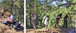 Figure
1
Figure
1
Students and instructors maintain social distancing and wear masks while mapping geologic structures in
the Black Hills of South Dakota (July 2020).
When selecting project areas, consideration was given to the additional need for extra parking space
given that the field camp was operating with twice as many vans as usual and there had to be enough room
to not only accommodate the extra vans, but if two or more cohorts were at the same project area, then
there had to be enough room for each cohort to be properly distanced.
Another key difference was that in a traditional field-camp course there is likely a senior instructor or
camp coordinator who would act as the lead instructor to facilitate the outcrop lectures and discussions
and/or other faculty who would take turns as lead instructor for different projects based on their areas
of expertise. There may even be cases where in the traditional setting, several instructors may come and
go over the period of five weeks to lead the various projects. Under the cohort model that we employed,
each cohort had two instructors assigned to the 10 students for the entire time, and there were no
exchanges or visits by other instructors. The instructors for each cohort had to be comfortable and
familiar enough with the geology of each of the project areas to be able to lead the outcrop discussions
and not rely on the senior instructor or another instructor for each of the different projects.
Transportation
Each cohort of 10 students and two faculty was assigned two 12-passenger vans for transportation to the
field, to evenly divide the cohort (Fig. 2). Front-to-back passenger seating in the four rows of each
vehicle was 2 – 1 – 1 – 2, and passengers were required to wear face coverings at all times in the
vehicle. Prior to entering the vehicle, temperature checks were recorded. Students were required to sit
in the same seat each day, and vans were loaded from back to front and unloaded from front to back. Upon
reaching the field and home destinations, disinfectant spray was used on all handled interior and
exterior vehicle surfaces. Furthermore, windows were kept open and air conditioning could be set to
high, but not to max because that would recirculate air.
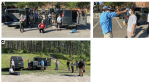 Figure
2
Figure
2
(A) Each cohort of ten students and two instructors was divided into two vans for transport to and from
field areas; (B) temperature checks were recorded prior to loading the vans; and (C) upon arrival in the
field, vans were unloaded from front to back and then sanitized as part of a multi-point COVID-19 safety
program.
Accommodations
Field-camp leaders worked closely with SDSMT campus authorities to accommodate students in
single-occupancy dorm rooms to mitigate the risk of a potential outbreak. Each 10-student cohort was
placed on a separate floor in Connolly Hall residential dormitory. Three instructors and 10 students
lived off campus, so only four instructors and 20 students lived on campus for the duration of the field
camp. On campus, all members of the field camp were required to socially distance and wear face
coverings. While it was impractical to monitor students’ after-hours activities, students were
encouraged not to go off campus because of the risk of being introduced to COVID-19 at bars and other
areas where social gatherings are common.
Dining
Field-camp leaders worked closely with SDSMT campus authorities to provide safe meals to mitigate the
risk of a potential outbreak. Dining took place at Surbeck Center in the main cafeteria. Upon entry and
wearing a face mask, members of the field camp were to stay spaced 6-feet (2 m) apart while a member of
the dining team served them their meal. Blue-tape Xs were placed on the floor to remind students to keep
the space of social distancing. Self-service was minimal. The dining room tables were spaced far apart
and only one person was allowed per table to facilitate social distancing. Furthermore, laminated cards
with “clean” and “dirty” sides were used to show which tables had been cleaned and were ready to
accommodate a diner, and following a meal, the card was to be flipped over, revealing to the dining team
that the table needed to be cleaned prior to accommodating the next diner.
Interpretation And Review Of The Hybrid Course
Students, instructors, and key stakeholders of the South Dakota state university system provided
important feedback (both anonymous and not) on the merits, limitations, and attributes of this course.
First, the introduction to field mapping methods online served three important purposes: (i) to provide
distinct exercises, most of them in different sedimentary basins from around the world and each on a
different mapping topic that is critical to the development of a well-rounded and successful field
geologist; (ii) to introduce digital mapping methods, including the use of freely accessible
high-resolution imagery and 3-D visualization such as Google Earth to aid in the field mapping process;
and (iii) to teach observational skills and first principles in sedimentary basin analysis (i.e., what
are the lithofacies, and how are different sedimentary structures throughout turbidite beds used to
determine paleocurrent direction, or what are the types of fractures, faults, and folds used to indicate
a certain type of deformation?). Probably the most popular feedback from students was the enjoyment of
using Google Earth to provide big-picture interpretations of structure. Second, students were challenged
to learn about a new basin or a completely new concept each day. This can take some focus and is akin to
the block program featured at some universities in the U.S., including Colorado College. Finally,
students enjoyed the fact that each day was a new topic, so that they remained rather fresh and engaged
throughout the course.
Some of the key limitations included: (i) exercises were demanding and took significant time, with some
students turning in homework after the midnight deadline; (ii) the material was completely new and took
focus to learn new lexicons of geologic terms required to adequately perform the exercises; and (iii)
Internet connectivity issues may have prevented students from hearing the entire lecture live. We
addressed these limitations by lowering the workload and setting greater flexibility on deadlines;
cutting back on the introduction of new and technical terminology; and recording lectures and putting
them and lecture material online the same day.
The 15-day field phase featured modules on rock identification, Laramide orogeny–related intrusions, and
the metamorphic core of the Black Hills. The key observations of this portion of the course included (i)
the regular four-day field mapping projects were challenging to scale down to two- to three-day–long
mapping projects with the additional health and safety requirements that were needed and in the absence
of a day off each week as in the past (five days were previously allowed to grade each project); (ii)
more time and lead time is required to do nearly everything in the field camp due to HS&E
requirements, leading to longer days for all involved; and (iii) it is more challenging to deliver
feedback in the form of grades and constructive criticism when there are no days purely devoted to rest
for the students and grading for the instructors.
While four days in the past were adequate to map structures such as the peak near Elkhorn Resort, an
asymmetric dome with an underlying intrusion just east of the Wyoming–South Dakota border, the limited
time and necessary spacing of cohorts required careful logistical planning. Additionally, flexibility
was paramount. Limited time meant that the students might be able to identify rock types and get the
structure correct, but for projects in the metamorphic core of the Black Hills, it became exceedingly
difficult to recognize multiple Black Hills deformational events in just two days of mapping. Second,
the enhanced HS&E protocols required longer times to do nearly everything because they were
accomplished by cohort, from breakfast, to loading the vans, to turning in homework, to distributing
field equipment, including Brunton compasses and GPS units. However, one camp event that likely was made
logistically easier during this course was the evening virtual meeting to introduce a new project or to
review Black Hills geology. Third, the feedback on student projects necessarily needed to be accelerated
because there were no rest days in the field portion of the course.
Additional challenges that occurred due to the shorter timeframe in the field included (i) unfamiliarity
with measuring fold axes and using a Brunton compass in general; (ii) unfamiliarity with actually
measuring a stratigraphic section in the field; (iii) difficulty in providing feedback via the virtual
platform or scanned images to students as they worked on their maps and cross sections (i.e., advised
not to provide close face-to-face feedback on projects); and (iv) having to schedule “office hours”
rather than students having full access to instructors during office days as in a normal BHNSFS camp.
These limitations and drawbacks to the online and hybrid approach need to be addressed by the field
geoscience education community.
Outlook For Geoscience Field-Based Education During Covid-19 Times
Like with science in general, our fields are never moribund. Based on our field-camp experience this
year, many of our peers have asked us to predict what will happen to field-based education over the next
5–10 years and in the immediate short term. We feel that while we are unable to make predictions, we can
forecast three key scenarios: (i) an increase in hybrid-type field courses with two phases similar to
our trial course, which limits the amount of time spent physically in the same location and thereby
decreases the risk of an outbreak; (ii) a decrease in field courses as universities accelerate online
teaching to accommodate the circumstances of the pandemic and increase global reach; and (iii) an
increase in field courses due to an increase in demand from the postponement, delay, and cancellation of
courses since early to mid-2020.
The first scenario may become increasingly common in the short term for the following reasons: (i)
instructors now have abundant material that they can use to teach remote courses; (ii) the wear-and-tear
of travel is significantly reduced for the student and instructor and requires much less logistical
preparation; and (iii) this scenario can accommodate both those who learn best online and in the field,
so it is more “equal” in its delivery.
The second scenario may occur due to budget cuts, a change in curriculum, or a wholesale acceptance that
field camp is no longer required for an undergraduate geoscience degree. We tend to disagree with all of
these reasons. For many universities adapting this type of training and course delivery, it bodes well
for demand for field courses run by field stations with fairly large year-round enrollments.
Third, we believe demand for field-based courses may actually rise. Of the ~250 students enrolled to take
our field camps for the summer of 2020, nearly 75% of them canceled and deferred for a later date.
Accounting for the students still in their sophomore and junior years who plan to enroll in field camp
during 2021–2022, this could represent a nearly 4× increase from 2020. This scenario will require
advance planning to provide space for all of the students who will enroll in field camp. This rather
optimistic scenario also agrees with other observations that “a field camp cannot be run online” and
that there is no substitute for “in-the-field mapping” to train students on field geology methods.
Conclusions
Due to the COVID-19 pandemic, many field-based geoscience programs have been temporarily suspended. The
experiences described herein provide a benchmark for planning and executing hybrid field geology courses
during the COVID-19 pandemic. Our aim is to provide these observations as a way to facilitate
constructive dialogue among the geoscience education community, including students and faculty and
stakeholders alike, to continually hone, refine, and innovate the way we educate our next generation of
earth scientists, many of whom will discover important energy resources for our world. We hope this
contribution will serve as a useful guide for universities and businesses planning to hold face-to-face
activities during this time of uncertainty.
Acknowledgments
This study could not have been possible without the support and data provided by the South Dakota School
of Mines and Technology and the Black Hills Natural Sciences Field Station. In particular, we thank the
late Dr. Alvis Lisenbee for his generosity of spirit in teaching us how to map the challenging terrain
of the Black Hills. Dr. Lisenbee spread joy for the geosciences and his enthusiasm for the thrill of
discovery in field mapping is a key mindset instilled in all of us. We also thank all of the students
and vendors (too numerous to name) involved in creating successful field camps throughout the years.
Thank you to D. Chiarella and an anonymous reviewer for their thorough and comprehensive reviews of the
manuscript that greatly improved its readability and impact. JR also thanks the brilliant and talented
Dr. Pooja Sodha for her inspiration to this contribution.
References Cited
- Anderson, K.S., Hickson, T.A., Crider, J.G., and Graham, S.A., 1999, Integrating teaching with field
research in the Wagon Rock project: Journal of Geoscience Education, v. 47, p. 227–235,
https://doi.org/10.5408/1089-9995-47.3.227.
- Bank, C., and Rotzien, J.R., 2007, Reflections by a Student and a Faculty Member on Student-Faculty
Collaborative Geophysical Field Research: American Geophysical Union Fall Meeting, San Francisco,
Calif., Supp., abstract no. ED33B-1223.
- Chiarella, D., and Vurro, G., 2020, Fieldwork and disability: An overview for an inclusive
experience: Geological Magazine, https://doi.org/10.1017/S0016756820000928.
- Oliveri, S., and Bohacs, K.M., 2005, Field safety in uncontrolled environments: A process-based
guidebook: AAPG, Division of Environmental Sciences, ExxonMobil Upstream Geoscience, 150 p.
- Rotzien, J.R., Sincavage, R., Pellowski, C., Gavillot, Y., Cooper, S., Shannon, J., Sawyer, J.F.,
Yildiz, U., Filkorn, H., and Uzunlar, N., 2020, Field-based geoscience education during the COVID-19
pandemic: Planning and execution, Part II: Geological Society of America, GSA 2020 Connects Online,
abstract no. 359659. https://doi.org/10.1130/abs/2020AM-359659.