Introduction
Plate tectonics shapes the evolution of the continents and oceans via the Wilson cycle, in which
continents rift to form new oceans. Many rifts evolve to passive continental margins. However, some
rifts fail before continental breakup and remain as fossil features within continents, which are largely
buried beneath the surface and studied primarily with gravity and seismic surveys. Failed rifts preserve
a snapshot of the rifting process before the beginning of seafloor spreading and thus give insight into
late stages of continental rifting and formation of passive continental margins (S. Stein et al., 2018;
Stein et al., 2022).
North America contains multiple impressive, failed rifts (Fig. 1), preserving important aspects of the
fabric of nearly two billion years of geologic history in Laurentia, its Precambrian core (Whitmeyer and
Karlstrom, 2007; Marshak and van der Pluijm, 2021). We focus on three major failed rifts, covering ~10%
of central North America (defined for these purposes as the area shown in Fig. 1A). One, the
Midcontinent Rift (MCR), is a prominent feature in geophysical maps of the region. Due to its size and
the availability of geophysical and geological data, the MCR has been the focus of many studies giving
insight into its evolution, role in the assembly of Rodinia, and processes of rifting and passive margin
evolution (e.g., Green et al., 1989; C. Stein et al., 2018; Swanson-Hysell et al., 2019). Two other
failed rifts, the Southern Oklahoma Aulacogen (SOA) and Reelfoot Rift (RR), have also been subjects of
much interest. Parts of the SOA lie within the basement near and below the Anadarko Basin, a major oil-
and gas-producing basin. Thus, its oil-bearing upper crust is well studied (Brewer et al., 1983; Keller
and Stephenson, 2007; Hanson et al., 2013), but the deeper structures in the lower crust and uppermost
mantle are rarely the primary target of study. The RR and its northern extensions, on the other hand,
have little interest for the energy industry but are of interest due to their active seismicity
(Hildenbrand and Hendricks, 1995; Calais et al., 2010).
 Figure
1
Figure
1
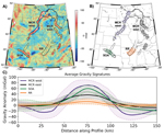
(A) Bouguer gravity anomaly map for central North America. Anomalies related to the Midcontinent Rift
(MCR), Southern Oklahoma Aulacogen (SOA), and Reelfoot Rift (RR) are outlined. Dashed lines outline
possible extensions of rift arms not included in analysis. (B) Profiles used in calculating the average
gravity anomalies. (C) Mean anomalies and standard deviations for rifts.
These three failed rifts are grossly similar, with similar tectonic origins and structural features, but
with interesting differences highlighting aspects of their evolution. These are shown by gravity data
that are uniformly sampled across the central U.S. (Fig. 1). In contrast, other data available differ
from area to area. In particular, high-quality seismic reflection data giving detailed structure at
depth that allows modeling of the rift’s evolution are available only across the part of the MCR below
Lake Superior. Conversely, EarthScope local seismic array data showing structure beneath the rift are
available only across parts of the MCR’s west arm and the RR.
Using gravity data from the PACES (Keller et al., 2006) and TOPEX data sets (Sandwell et al., 2013), we
extracted profiles 150 km long and ~50 km apart across each rift (Fig. 1B). Figure 1C shows each rift’s
mean Bouguer anomaly and standard deviation. The mean profiles show differences between rifts,
reflecting their tectonic origin and subsurface structure. The MCR’s west arm shows large gravity highs
(~80 mGal) bounded by ~20 mGal lows on either side of the rift basin. In contrast, the MCR’s east arm
has a positive anomaly half that of the west arm and lacks bounding lows. The Southern Oklahoma
Aulacogen has an ~60 mGal positive anomaly, similar to the MCR, whereas the RR shows only a minor
(~10–15 mGal) positive anomaly despite forming about the same time as the SOA.
The profiles are generally similar in width and form, but differ in amplitude, suggesting general
similarities in crustal and uppermost mantle structure between the rifts. We use the mean gravity
profiles augmented with seismic and other data, combined with results from earlier studies, to model the
rifts’ general subsurface structures. We start with the hypothesis that the rifts are similar, and so
when needed use inferences from one rift to gain insight into the others, to the extent that the data
permit. Although models from gravity data alone are non-unique, augmenting them with information from
seismic, aeromagnetic, surface mapping, and drill-hole data lets us characterize average structure along
the rifts and illustrate similarities and differences between them. The similarities and differences
reflect the combined effects of a sequence of rifting, volcanism, sedimentation, subsidence,
compression, erosion, and later effects (Stein et al., 2015; Elling et al., 2020). They give insight
into how rifts evolve and are useful when studying other failed or active rifts elsewhere.
Midcontinent Rift
The Midcontinent Rift (MCR), a 3000-km-long band of more than 2 million km3 of buried igneous
and sedimentary rocks that outcrop near Lake Superior, has been extensively studied, as reviewed by
Ojakangas et al. (2001) and S. Stein et al. (2018). To the south, it is buried by younger sediments, but
easily traced because the rift-filling volcanic rocks are dense and highly magnetized. The western arm
extends southward to Oklahoma, as shown by positive gravity anomalies and similar-age diffuse volcanism
(Bright et al., 2014). The eastern arm extends southward to Alabama (Keller et al., 1983; C. Stein et
al., 2014, 2018; S. Stein et al., 2018; Elling et al., 2020). The MCR likely formed as part of rifting
of the Amazonia craton (now in northeastern South America) from Laurentia, the Precambrian core of North
America at 1.1 Ga, after the Elzeverian and Shawinigan orogenies and before the Grenville Orogeny (C.
Stein et al., 2014, 2018; S. Stein et al., 2018). Surface exposures, seismic data, and gravity data
delineate rift basins filled by thick basalt layers and sediments, underlain by thinned crust and an
underplate unit, presumably the dense residuum from the magma extraction (Vervoort et al., 2007; S.
Stein et al., 2018). The rift was later massively inverted by regional compression, uplifting the
volcanic rocks so that some are exposed at the surface today. The MCR has little seismicity along most
of its length, but portions in Kansas and Oklahoma experienced seismicity and Phanerozoic deformation
(Burberry et al., 2015; Levandowski et al., 2017).
We developed models for each arm (Figs. 2A and 2B), following Elling et al. (2020), because the west
arm’s larger gravity anomaly indicates differences in magma volume and tectonic evolution. For
simplicity, the models use average densities of the sediment, igneous rift fill, underlying crust,
underplate, and mantle. We began with GLIMPCE seismic reflection profiles across Lake Superior that give
the best available image of structure at depth in the MCR (Green et al., 1989) and permit detailed
modeling of its evolution (Stein et al., 2015). We also considered prior gravity models across parts of
the MCR (Mayhew et al., 1982; Shay and Trehu, 1993). EarthScope data (Zhang et al., 2016) provided
values for the depth and thickness of the volcanics and underplate along the west arm that were used to
update the models. These data showed that structure below the west arm resembles that below Lake
Superior, suggesting that the structure along the entire MCR is similar. On either side of the central
rift basin, basins ~5 km thick resulting from post-rift sedimentation produce bounding gravity lows. The
sediments are much thinner over the central basin as a result of inversion, uplift, and erosion after
rift failure.
 Figure
2
Figure
2
Gravity data and rift models. (A) West Midcontinent Rift (MCR) arm, with underplate based on receiver
function data (dots). (B) East MCR arm, modeled with underplate like the west arm’s, dashed given its
uncertainty. (C) Southern Oklahoma Aulacogen (SOA), with proposed underplate dashed given its
uncertainty. (D) Reelfoot Rift (RR), with underplate based on receiver function data (dots). (E) Model
for the SOA if it had not been inverted, eliminating the positive anomaly. (F) Model for the RR if it
had been inverted, producing a positive anomaly. Densities in g/cm
3.
We model the east arm as similar to the west. Because the east arm does not show bounding gravity lows,
the model does not include bounding basins. We include an underplate like that below the west arm,
although seismic data needed to resolve it are lacking, because such underplates are also seen below the
RR, have been proposed below the SOA, are common in rifts worldwide (Thybo and Artemieva, 2013; Rooney
et al., 2017), and are expected given the igneous rift fill (Vervoort et al., 2007). The largest
difference between the models is the thickness of rift-filling volcanics; the west arm contains 20–25 km
of volcanics, whereas the east arm contains 10–15 km. The dense igneous rocks affect the gravity anomaly
much more than the underplate, so the geometry of the volcanics in the east arm was adjusted to match
the gravity profiles.
Southern Oklahoma Aulacogen
The Southern Oklahoma Aulacogen (SOA) (Walper, 1977) is a linear alignment of extensively inverted rift
structures perpendicular to the southern tip of the MCR’s west arm. Its main structures are the Wichita
uplift (and associated igneous provinces) and Anadarko Basin. Both the SOA and RR (discussed shortly)
initiated as the Cuyania block, also known as the Argentine Precordillera, rifted away from Laurentia
(Thomas, 2011; Whitmeyer and Karlstrom, 2007). Rifting is thought to have begun in latest Precambrian,
but the oldest dates come from SOA igneous rocks dated at ca. 540 Ma (Wall et al., 2021).
The SOA’s geologic and tectonic history has three major phases. The first involved emplacement of the
Wichita Igneous Province during development of a rift beginning in the Ediacaran to mid-Cambrian (Brewer
et al., 1983; Perry, 1989; Wall et al., 2021). Extensional and transtensional tectonism within the SOA
developed during the latest Precambrian–Cambrian opening of the southern Iapetus Ocean as part of
Rodinia’s breakup (Robert et al., 2021). Following rift failure, thermal subsidence allowed deposition
of thick sedimentary sequences, marking the onset of the Anadarko Basin formation (Perry, 1989; Johnson,
2008). Finally, Late Mississippian through Pennsylvanian compression inverted the SOA and formed a
NE-trending fold-thrust belt containing the Wichita and Arbuckle Mountains (Keller and Stephenson,
2007). The compression is believed to be related to North America’s collision with Africa and South
America during the Alleghenian Orogeny (Kluth and Coney, 1981) or tectonic activity along North
America’s western and southwestern margins (Lawton et al., 2017; Leary et al., 2017). The SOA exposes
only a fraction of its extent in the Wichita Mountains and contains more than 210,000 km3 of
buried mafic rocks up to 10 km thick along the entire rift (Hanson et al., 2013), along with a large
volume of felsic igneous rocks, including granitic intrusions and interbedded rhyolites. Emplacement and
subsequent inversion of the igneous rocks yielded a positive gravity anomaly of ~60 mGal, similar to the
average of the MCR arms.
Our SOA model is modified from Keller and Stephenson’s (2007) model based on gravity, seismic,
aeromagnetic, surface mapping, and drilling data. Seismic reflection data were used to constrain the
location and thicknesses of the gabbroic and felsic intrusions producing the large positive anomaly. We
simplified their model for comparison with the other rifts. Sedimentary basin rocks were averaged into a
few units, and bodies within the gabbroic intrusion that increased in density with depth in the original
model were averaged to a single density. Keller and Baldridge (1995) proposed the presence of an
underplate, which is consistent with the gravity data and included in our model, though seismic data
adequate to confirm (or disprove) its presence are not available.
Reelfoot Rift
The Reelfoot Rift (RR) underlies the Upper Mississippi Embayment, a broad trough with a complex history
of rifting and subsidence (Catchings, 1999). The NE-trending graben of the RR is 70 km wide and more
than 300 km long. Reflection profiles and mafic alkalic plutons suggest several episodes of faulting and
intrusive activity (Mooney et al., 1983). The RR is believed to have experienced multiple phases of
subsidence (Ervin and McGinnis, 1975), with the earliest rifting in the Ediacaran associated with
widespread rifting along North America’s margins during the breakup of Rodinia. The rift basin primarily
developed during this Cambrian event. Later subsidence, perhaps as late as the Cretaceous, is associated
with emplacement of mafic igneous intrusives inside the rift and deposition of several kilometers of
sediments that bury them (Hildenbrand and Hendricks, 1995; Cox and Van Arsdale, 2002). Relative to the
MCR and SOA, the RR experienced significantly less volcanic activity during rifting, and its subsidence
influenced the sedimentation and subsequent development of the drainage basins of major rivers, such as
the Mississippi. Climate-controlled erosion and unloading of sediments that fill the rift basin have
been proposed to have triggered the present seismicity (New Madrid seismic zone) on faults remaining
from the rifting (Calais et al., 2010).
We developed our model by modifying one by Liu et al. (2017) based on their work and earlier models
constrained by seismic refraction, gravity, and magnetic data (Mooney et al., 1983; Braile et al., 1986;
Nelson and Zhang, 1991). Earlier studies identified an underplate, or “rift pillow,” whose location is
constrained by Liu et al.’s (2017) results. An underplate has also been observed along the RR’s
northeastern extension (Aziz Zanjani et al., 2019). A feature of our model, required to replicate the
lack of a large gravity anomaly, is that the RR contains far less high-density volcanics than the other
rifts, perhaps because it extended less. Low-density Quaternary sediments of the Mississippi River basin
overlying the rift rocks also contribute to the minimal anomaly.
Similarities and Differences
Comparing the three rifts’ average gravity profiles and subsurface structures inferred in part from them
illustrates similarities and differences between the rifts.
Tectonic Setting
All three formed during rifting associated with Laurentia’s interactions within the supercontinent of
Rodinia. The MCR formed after the Elzeverian and Shawinigan orogenies and before the Grenville Orogeny
that assembled Rodinia (e.g., Hynes and Rivers, 2010). Its formation was likely associated with rifting
between Laurentia and Amazonia during a plate boundary reorganization (S. Stein et al., 2014, 2018)
(Fig. 3A), although details of Amazonia’s location and motion are not well constrained at this time
because of limited paleomagnetic data (Tohver et al., 2006; Li et al., 2008).
 Figure
3
Figure
3
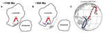
(A) Schematic reconstruction of plate positions relative to Laurentia ca. 1100 Ma during formation of
Rodinia. After the Elzeverian and Shawinigan orogenies, but before the Grenville orogeny, spreading
likely initiated between the major plates. Following failure of the Midcontinent Rift (MCR), Amazonia
shifted north along the margin before recolliding. (B) Similar reconstruction at ca. 560 Ma as Rodinia
was breaking up. Cuyania (Cu) block rifted off Laurentia, leaving the Southern Oklahoma Aulacogen (SOA)
and Reelfoot Rift (RR) as failed arms. (C) Apparent polar wander (APW) path of Laurentia, plotted in
present-day coordinates, at 10-m.y. increments. Red cusp (1200–1000 Ma) is related to formation of the
MCR, and blue cusp (700–500 Ma) is related to initial rifting of the SOA and RR. Path between these
events plotted in gray.
Additional evidence for this view comes from a change in Laurentia’s absolute plate motion around the
time of the formation of the MCR. A global plate model (Scotese and Elling, 2017), updated with a global
compilation of paleomagnetic poles (McElhinny and Lock, 1996; Torsvik et al., 2008, 2012; Merdith et
al., 2017; Scotese and Van der Voo, 2017; Veikkolainen et al., 2017), was inverted to generate synthetic
apparent polar wander (APW) paths that match the plate model. Comparison with global mean poles (GMP)
revealed these synthetic APW paths produce a good fit within the α95 error of the GMPs. Laurentia’s APW
path has a major cusp, called the Logan Loop, recorded in part by the MCR’s volcanic rocks (Fig. 3C).
Cusps in APW paths have been observed elsewhere when continents rift apart (Gordon et al., 1984). A
similar cusp appears ca. 600 Ma in this model (Fig. 3C), during opening of the Iapetus Ocean as the
Argentine Precordillera microcontinent rifted from the Wichita embayment on Laurentia’s SE margin
(Whitmeyer and Karlstrom, 2007; Thomas, 2011). Both the SOA and RR opened as arms of this triple
junction but ultimately failed (Fig. 3B).
Spatial Scale and Architecture
The three rifts have similar spatial scales and structures that seem to characterize failed rifts. Their
central grabens, filled with volcanic and sedimentary rocks, are bounded by faults that presumably had
normal fault motion during extension. Despite structural differences, all three rifts are ~60–80 km
wide, suggesting that failed rifts are consistent with observations that presently spreading rifts had
initial widths controlled by crustal thickness rather than the extension history (Allemand and Brun,
1991).
For the MCR and SOA, the rifting faults were reactivated as reverse faults during subsequent inversion.
The SOA’s gravity high reflects structural inversion of basaltic and gabbroic material in the Wichita
Mountains, but significant amounts of rift-fill remain buried beneath the Anadarko Basin (Keller and
Stephenson, 2007). Although the RR looks similar overall, it was not significantly reactivated by later
inversion. This left its rift-filling volcanics deeper in the subsurface, causing the absence of a
positive gravity anomaly. This effect is illustrated by a model showing the gravity anomaly at different
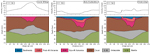
stages in the MCR’s evolution (Fig. 4), derived from cross-section–balanced reconstructions from GLIMPCE
data (Stein et al., 2015). During rifting, dense volcanics near the surface would have caused a large
positive anomaly. Subsequent deposition of low-density sediments and subsidence that depressed the
volcanics would have caused a gravity low. Eventually, inversion of the rift and erosion and removal of
low-density sediments brought the volcanics closer to the surface, causing today’s gravity high. Without
this inversion, a positive anomaly would not have developed.
 Figure
4
Figure
4
Gravity anomalies expected at various stages in rift evolution, based on model for the Midcontinent Rift
under Lake Superior. During rifting, dense volcanics cause a large positive anomaly. Subsequent
deposition of low-density sediments and associated subsidence cause a gravity low. Inversion of the rift
and erosion of low-density sediments cause the high observed today. Densities in g/cm
3.
(After Elling et al., 2020.)
We explored the hypothesis that inversion is crucial for producing a positive gravity anomaly using the
SOA and RR. The SOA experienced up to 15 km of inversion in the late Paleozoic (Keller and Stephenson,
2007). “Uninverting” the rift by re-burying the gabbroic fill 12 km below a sedimentary basin eliminates
the positive anomaly (Fig. 2E). Hence the SOA’s gravity high largely reflects the inversion. Conversely,
because the RR did not experience significant inversion, its rift basin is buried beneath low-density
sediments. Inverting the RR by 3 km and removing sediments overlying the basin (Fig. 2F) produces a
positive anomaly due to the high-density igneous rift fill being much nearer to the surface.
Igneous Rock Volumes
There are interesting differences in the volumes of rift volcanics. The MCR is ~3000 km long and contains
more than 2 million km3 of buried igneous rocks, while the SOA and RR are both roughly 1/10
the length of the MCR and contain significantly less volcanics. Although the SOA’s volcanic package
produces a large positive gravity anomaly, it contains only ~1/10 as much volcanics as the MCR (Hanson
et al., 2013).
The differences appear in the cross sections. Volcanics in MCR’s west and east arms have average
cross-sectional areas of 1100 km2 and 680 km2, the SOA has an average
cross-sectional area of 470 km2, whereas the RR’s cross-sectional area is much smaller (160
km2). How these differences arose is unclear. The volumes of igneous rocks produced in
rifting can reflect two effects. The first is passive rifting in which extension due to far-field forces
causes lithospheric thinning and inflow of hot asthenosphere, such that greater extension produces more
melt (Koptev et al., 2015). The second, active rifting, involves an upwelling thermal plume, such that
melt is generated by elevated mantle temperatures beneath the lithosphere (Burov and Gerya, 2014). The
relative roles of these and other possible rifting processes (King, 2007) are extensively debated but
remain unclear (Foulger, 2010). Both active and passive rifting have been invoked to explain the volumes
of volcanic rocks at rifted continental margins (White and McKenzie, 1989; Richards et al., 1989; van
Wijk et al., 2001). Gallahue et al. (2020) find evidence for both processes on continental margins, with
passive rifting having a stronger effect.
A plume contribution for the MCR has been inferred from petrologic and geochemical data (Nicholson et
al., 1997; White, 1997; Davis et al., 2021), consistent with the enormous volume of volcanic rocks
making it a Large Igneous Province (Green, 1983; Stein et al., 2015). The large volume of MCR rocks also
likely reflects Precambrian mantle temperatures higher than today’s (Korenaga, 2013). The difference
between the west and east arms likely reflects a difference in the amount of extension during rifting
(Merino et al., 2013; Elling et al., 2020). The smaller cross-sectional areas of volcanics in the SOA
and RR probably do not require assuming a plume. Hence, in our view, the simplest explanation of the
differences between the SOA and RR, which formed about the same time in similar events, is that the RR
had less extension and inversion.
Although models without underplates could fit the gravity data, we include underplates because seismic
data both from the MCR (below Lake Superior and on its west arm) and RR show them, and underplates are
typically observed at presently spreading rifts. Furthermore, underplates are thought to form from
residual melt after extraction of low-density lavas and would be expected given the volume of volcanic
material in these rifts. We expect their size to be proportional to the volume (cross-sectional area) of
volcanics, as observed for rifted continental margins (Gallahue et al., 2020). Hence, the similar
underplates beneath the western MCR and RR are surprising, given that the MCR has roughly ten times more
volcanics in cross section. One possible explanation is that in addition to the volcanics in our RR
model, another volcanic unit, a mafic high-density upper crustal layer, also exists. Liu et al. (2017,
p. 4581) suggest this possibility while noting that such a layer is not required by the data and would
be “rare, if not previously unrecognized, for continental rifts.” Another possibility is that during the
mid-Cretaceous, as the area passed over the Bermuda plume (Cox and Van Arsdale, 2002), plume-derived
material may have augmented the underplate. An improved understanding of the relation between the
volcanics and underplate would be helpful in understanding the transition between the final stages of
continental rifting and early stages of seafloor spreading.
Conclusions
Traditionally, studies have considered the major failed rifts in central North America separately.
However, it is useful to consider them as similar although not identical entities and to view them in
the context of both failed and active rifts worldwide. Although they are grossly similar, with similar
tectonic origins and structural features, interesting differences between them reflect the extent to
which extension, magmatism, subsidence, and inversion by later compression occurred. Further study of
these and other failed rifts would provide additional insight into how many rifts transition from the
final stages of continental rifting to the early stages of seafloor spreading.
Acknowledgments
We thank our many collaborators during a decade of rift studies synthesized here. In particular, Randy
Keller provided his broad knowledge and deep insight about continental rifting both in North America and
elsewhere. We also thank Nick Swanson-Hysell and anonymous reviewers for helpful suggestions, along with
Jim Schmitt for constructive discussions and timely editorial processing of this manuscript.
References Cited
- Allemand, P., and Brun, J., 1991, Width of continental rifts and rheological layering of the
lithosphere: Tectonophysics, v. 188, p. 63–69, https://doi.org/10.1016/0040-1951(91)90314-I.
- Aziz Zanjani, A., Zhu, L., Herrmann, R., Liu, Y., Gu, Z., and Conder, J., 2019, Crustal structure
beneath the Wabash Valley Seismic Zone from joint inversion of receiver functions and surface-wave
dispersion: Journal of Geophysical Research, v. 124, p. 7028–7039,
https://doi.org/10.1029/2018JB016989.
- Braile, L., Hinze, W., Keller, G., Lidiak, E., and Sexton, J., 1986, Tectonic development of the New
Madrid rift complex: Tectonophysics, v. 131, p. 1–21, https://doi.org/10.1016/0040-1951(86)90265-9.
- Brewer, J., Good, R., Oliver, J., Brown, L., and Kaufman, S., 1983, COCORP profiling across the
Southern Oklahoma aulacogen: Geology, v. 11, p. 109–114,
https://doi.org/10.1130/0091-7613(1983)11<109:CPATSO>2.0.CO;2.
- Bright, R., Amato, J., Denyszyn, S., and Ernst, R., 2014, U-Pb geochronology of 1.1 Ga diabase in
the southwestern United States: Lithosphere, v. 6, p. 135–156, https://doi.org/10.1130/L335.1.
- Burberry, C., Joeckel, R., and Korus, J., 2015, Post-Mississippian tectonics of the Nemaha Tectonic
Zone and Mid-Continent Rift System: The Mountain Geologist, v. 52, no. 4, p. 47–73.
- Burov, E., and Gerya, T., 2014, Asymmetric three-dimensional topography over mantle plumes: Nature,
v. 513, p. 85–89, https://doi.org/10.1038/nature13703.
- Calais, E., Freed, A., Van Arsdale, R., and Stein, S., 2010, Triggering of New Madrid seismicity by
late-Pleistocene erosion: Nature, v. 466, p. 608–611, https://doi.org/10.1038/nature09258.
- Catchings, R., 1999, Regional Vp, Vs, Vp/Vs, and Poisson’s ratios across
earthquake source zones from Memphis, Tennessee, to St. Louis, Missouri: Bulletin of the
Seismological Society of America, v. 89, p. 1591–1605, https://doi.org/10.1785/BSSA0890061591.
- Cox, R., and Van Arsdale, R., 2002, The Mississippi embayment: Journal of Geodynamics, v. 34, p.
163–176, https://doi.org/10.1016/S0264-3707(02)00019-4.
- Davis, W., Collins, M., Rooney, T., Brown, E., Stein, C., Stein, S., and Moucha, R., 2021,
Geochemical, petrographic, and stratigraphic analyses of the Portage Lake Volcanics of the
Keweenawan CFBP, in Srivastava, R.K., et al., eds., Large Igneous Provinces and their
Plumbing Systems: Geological Society, London, Special Publication 518, p. 67–100,
https://doi.org/10.1144/SP518-2020-221.
- Elling, R., Stein, S., Stein, C., and Keller, G., 2020, Tectonic implications of the gravity
signatures of the Midcontinent Rift and Grenville Front: Tectonophysics, v. 778, p. 6,
https://doi.org/10.1016/j.tecto.2020.228369.
- Ervin, C., and McGinnis, L., 1975, Reelfoot Rift: Reactivated precursor to the Mississippi
Embayment: Geological Society of America Bulletin, v. 86, p. 1287–1295,
https://doi.org/10.1130/0016-7606(1975)86<1287:RRRPTT>2.0.CO;2.
- Foulger, G., 2010, Plates vs. Plumes: A Geological Controversy: Chichester, UK, Wiley-Blackwell, 364
p., https://doi.org/10.1002/9781444324860.
- Gallahue, M., Stein, S., Stein, C., Jurdy, D., Barklage, M., and Rooney, T., 2020, A compilation of
igneous rock volumes at volcanic passive continental margins from interpreted seismic profiles:
Marine and Petroleum Geology, v. 122, 104635, https://doi.org/10.1016/j.marpetgeo.2020.104635.
- Gordon, R., Cox, A., and O’Hare, S., 1984, Paleomagnetic Euler poles and the apparent polar wander
and absolute motion of North America since the Carboniferous: Tectonics, v. 3, p. 499–537,
https://doi.org/10.1029/TC003i005p00499.
- Green, A., Cannon, W., Milkereit, B., Hutchinson, D., Davidson, A., Behrendt, J., Spencer, C., Lee,
M., Morel-á-LáHuissier, P., and Agena, W., 1989, A “GLIMPCE” of the deep crust beneath the Great
Lakes, in Mereu, R., Mueller, S., and Fountain, D., eds., Properties and Processes of
Earth’s Lower Crust: Washington, D.C., American Geophysical Union, Geophysical Monograph 51, p.
65–80, https://doi.org/10.1029/GM051p0065.
- Green, J.C., 1983, Geologic and geochemical evidence for the nature and development of the middle
Proterozoic (Keweenawan) midcontinent rift of North America: Tectonophysics, v. 94, p. 413–437,
https://doi.org/10.1016/0040-1951(83)90027-6.
- Hanson, R.E., Puckett, R.E., Jr., Keller, G.R., Brueseke, M.E., Bulen, C.L., Mertzman, S.A.,
Finegan, S.A., and McCleery, D.A., 2013, Intraplate magmatism related to the opening of the southern
Iapetus Ocean: Lithos, v. 174, p. 57–70, https://doi.org/10.1016/j.lithos.2012.06.003.
- Hildenbrand, T., and Hendricks, J., 1995, Geophysical setting of the Reelfoot Rift and relations
between rift structures and the New Madrid seismic zone: U.S. Geological Survey Professional Paper
1538-E, https://doi.org/10.3133/pp1538E.
- Hynes, A., and Rivers, T., 2010, Protracted continental collision—Evidence from the Grenville
orogen: Canadian Journal of Earth Sciences, v. 47, p. 591–620, https://doi.org/10.1139/E10-003.
- Johnson, K., 2008, Geologic history of Oklahoma. Earth sciences and mineral resources of Oklahoma:
Oklahoma Geological Survey Publication 9, p. 3–5.
- Keller, G., and Baldridge, W., 1995, The Southern Oklahoma aulacogen, in Olsen, K., ed.,
Continental Rifts: Evolution, Structure, Tectonics: Amsterdam, Elsevier, p. 427–435.
- Keller, G., and Stephenson, R., 2007, Southern Oklahoma and Dniepr-Donets aulacogens: A comparative
analysis, in Hatcher, R., Jr., Carlson, M., McBride, J., and Catalán, M., eds., 4-D
Framework of Continental Crust: Geological Society of America Memoir 200., p. 127–143,
https://doi.org/10.1130/2007.1200(08).
- Keller, G., Lidiak, E., Hinze, W., and Braile, L., 1983, The role of rifting in the tectonic
development of the midcontinent, U.S.A.: Tectonophysics, v. 94, p. 391–412,
https://doi.org/10.1016/0040-1951(83)90026-4.
- Keller, G., and 16 others, 2006, A community effort to construct a gravity database for the U.S. and
an associated web portal, in Sinha, A., ed., Geoinformatics: Data to Knowledge: Geological
Society of America Special Paper 397, p. 21–34, https://doi.org/10.1130/2006.2397(02).
- King, S., 2007, Hotspots and edge-driven convection: Geology, v. 35, p. 223–226,
https://doi.org/10.1130/G23291A.1.
- Kluth, C., and Coney, P., 1981, Plate tectonics of the ancestral Rocky Mountains: Geology, v. 9, p.
10–15, https://doi.org/10.1130/0091-7613(1981)9<10:PTOTAR>2.0.CO;2.
- Koptev, A., Calais, E., Burov, E., Leroy, S., and Gerya, T., 2015, Dual continental rift systems
generated by plume–lithosphere interaction: Nature Geoscience, v. 8, p. 388–392,
https://doi.org/10.1038/ngeo2401.
- Korenaga, J., 2013, Initiation and evolution of plate tectonics on Earth: Annual Review of Earth and
Planetary Sciences, v. 41, p. 117–151, https://doi.org/10.1146/annurev-earth-050212-124208.
- Lawton, T., Cashman, P., Trexler, J., and Taylor, W., 2017, The late Paleozoic Southwestern
Laurentian Borderland: Geology, v. 45, p. 675–678, https://doi.org/10.1130/G39071.1.
- Leary, R., Umhoefer, P., Smith, M., and Riggs, N., 2017, A three-sided orogen: A new tectonic model
for Ancestral Rocky Mountain uplift and basin development: Geology, v. 45, p. 735–738,
https://doi.org/10.1130/G39041.1.
- Levandowski, W., Zellman, M., and Briggs, R., 2017, Gravitational body forces focus North American
intraplate earthquakes: Nature Communications, v. 8, 14314, https://doi.org/10.1038/ncomms14314.
- Li, Z.X., and 16 others, 2008, Assembly, configuration, and break-up history of Rodinia: A
synthesis: Precambrian Research, v. 160, p. 179–210,
https://doi.org/10.1016/j.precamres.2007.04.021.
- Liu, L., Gao, S., Liu, K., and Mickus, K., 2017, Receiver function and gravity constraints on
crustal structure and vertical movements of the Upper Mississippi Embayment and Ozark Uplift:
Journal of Geophysical Research, v. 122, p. 4572–4583, https://doi.org/10.1002/2017JB014201.
- Marshak, S., and van der Pluijm, B., 2021, Tectonics of the Continental Interior in the United
States, in Alderton, D., and Elias, S., eds., Encyclopedia of Geology (2nd ed.): Oxford,
UK, Academic Press, v. 4, p. 173–186, https://doi.org/10.1016/B978-0-08-102908-4.00139-9.
- Mayhew, M., Thomas, H., and Wasilewski, P., 1982, Satellite and surface geophysical expression of
anomalous crustal structure in Kentucky and Tennessee: Earth and Planetary Science Letters, v. 58,
p. 395–405, https://doi.org/10.1016/0012-821X(82)90088-7.
- McElhinny, M.W., and Lock, J., 1996, Iaga paleomagnetic databases with access: Surveys in
Geophysics, v. 17, p. 575–591, https://doi.org/10.1007/BF01888979.
- Merdith, A.S., and 11 others, 2017, A full-plate global reconstruction of the Neoproterozoic:
Gondwana Research, v. 50, p. 84–134, https://doi.org/10.1016/j.gr.2017.04.001.
- Merino, M., Keller, G., Stein, S., and Stein, C., 2013, Variations in Mid-Continent Rift magma
volumes consistent with microplate evolution: Geophysical Research Letters, v. 40, p. 1513–1516,
https://doi.org/10.1002/grl.50295.
- Mooney, W., Andrews, M.C., Ginzburg, A., Peters, D.A., and Hamilton, R.M., 1983, Crustal structure
of the Northern Mississippi Embayment and a comparison with other continental rift zones:
Tectonophysics, v. 94, p. 327–348, https://doi.org/10.1016/0040-1951(83)90023-9.
- Nelson, K., and Zhang, J., 1991, A COCORP deep reflection profile across the buried Reelfoot rift:
Tectonophysics, v. 197, p. 271–293, https://doi.org/10.1016/0040-1951(91)90046-U.
- Nicholson, S., Shirey, S., Schulz, K., and Green, J., 1997, Rift-wide correlation of 1.1 Ga
Midcontinent rift system basalts: Canadian Journal of Earth Sciences, v. 34, p. 504–520,
https://doi.org/10.1139/e17-041.
- Ojakangas, R., Morey, G., and Green, J., 2001, The Mesoproterozoic midcontinent rift system:
Sedimentary Geology, v. 141–142, p. 421–442, https://doi.org/10.1016/S0037-0738(01)00085-9.
- Perry, W., Jr., 1989, Tectonic evolution of the Anadarko basin region: U.S. Geological Survey
Bulletin 1866.
- Richards, M., Duncan, R., and Courtillot, V., 1989, Flood basalts and hot-spot tracks: Science, v.
246, p. 103–107, https://doi.org/10.1126/science.246.4926.103.
- Robert, B., Domeier, M., and Jakob, J., 2021, On the origins of the Iapetus Ocean: Earth-Science
Reviews, v. 221, 46 p.
- Rooney, T., Lavigne, A., Svoboda, C., Girard, G., Yirgu, G., Ayalew, D., and Kappelman, J., 2017,
The making of an underplate: Pyroxenites from the Ethiopian lithosphere: Chemical Geology, v. 455,
p. 264–281, https://doi.org/10.1016/j.chemgeo.2016.09.011.
- Sandwell, D., Garcia, E., Soofi, K., Wessel, P., Chandler, M., and Smith, W.H.F., 2013, Towards 1
mGal global marine gravity from CryoSat-2, Envisat, and Jason-1: The Leading Edge, v. 32, p.
892–899, https://doi.org/10.1190/tle32080892.1.
- Scotese, C., and Elling, R., 2017, Plate tectonic evolution during the last 1.5 billion years: The
Movie, Plate Tectonics at 50, William Smith Meeting, October 3–5, 2017, The Geological Society,
Burlington House, London, p. 16–17.
- Scotese, C., and Van der Voo, R., 2017, A paleomagnetic database for GPlates: Paleopoles,
declination arrows, and paleolatitudes: GPlates Tutorial, 52 p.
- Shay, J., and Trehu, A., 1993, Crustal structure of the central graben of the Midcontinent Rift
beneath Lake Superior: Tectonophysics, v. 225, p. 301–335,
https://doi.org/10.1016/0040-1951(93)90303-2.
- Stein, C., Stein, S., Merino, M., Keller, G.R., Flesch, L.M., and Jurdy, D.M., 2014, Was the
Midcontinent Rift part of a successful seafloor spreading episode?: Geophysical Research Letters,
v. 41, p. 1465–1470, https://doi.org/10.1002/2013GL059176.
- Stein, C., Kley, J., Stein, S., Hindle, D., and Keller, G., 2015, North America’s Midcontinent Rift:
When rift met LIP: Geosphere, v. 11, p. 1607–1616, https://doi.org/10.1130/GES01183.1.
- Stein, C., Stein, S., Elling, R., Keller, G., and Kley, J., 2018, Is the “Grenville Front” in the
central United States really the Midcontinent Rift?: GSA Today, v. 28, p. 4–10,
https://doi.org/10.1130/GSATG357A.1.
- Stein, C.A., Stein, S., Gallahue, M.M., and Elling, R.P., 2022, Revisiting hotspots and continental
breakup—Updating the classical three-arm model, in Foulger, G.R., Hamilton, L.C., Jurdy,
D.M., Stein, C.A., Howard, K.A., and Stein, S., eds., In the Footsteps of Warren B. Hamilton: New
Ideas in Earth Science: Geological Society of America Special Paper 553, p. 41–57,
https://doi.org/10.1130/2021.2553(05).
- Stein, S., Stein, C., Elling, R., Kley, J., Keller, R., Wysession, M., Rooney, T., Frederiksen, A.,
and Moucha, R., 2018, Insights from North America’s failed Midcontinent Rift into the evolution of
continental rifts and passive continental margins: Tectonophysics, v. 744, p. 403–421,
https://doi.org/10.1016/j.tecto.2018.07.021.
- Swanson-Hysell, N., Ramezani, J., Fairchild, L., and Rose, I., 2019, Failed rifting and fast
drifting: Midcontinent Rift development, Laurentia’s rapid motion and the driver of Grenvillian
orogenesis: Geological Society of America Bulletin, v. 131, p. 913–940,
https://doi.org/10.1130/B31944.1.
- Thomas, W., 2011, The Iapetan rifted margin of southern Laurentia: Geosphere, v. 7, p. 97–120,
https://doi.org/10.1130/GES00574.1.
- Thybo, H., and Artemieva, I., 2013, Moho and magmatic underplating in continental lithosphere:
Tectonophysics, v. 609, p. 605–619, https://doi.org/10.1016/j.tecto.2013.05.032.
- Tohver, E., D’Agrella-Filho, M., and Trindade, R., 2006, Paleomagnetic record of Africa and South
America for the 1200–500 Ma interval, and evaluation of Rodinia and Gondwana assemblies: Precambrian
Research, v. 147, p. 193–222, https://doi.org/10.1016/j.precamres.2006.01.015.
- Torsvik, T.H., Muller, R., Van der Voo, R., Steinberger, B., and Gaina, C., 2008, Global plate
motion frames: Toward a unified model: Reviews of Geophysics, v. 46, 44 p.
- Torsvik, T.H., and 12 others, 2012, Phanerozoic polar wander, palaeogeography and dynamics:
Earth-Science Reviews, v. 114, p. 325–368, https://doi.org/10.1016/j.earscirev.2012.06.007.
- van Wijk, J., Huismans, R., Ter Voorde, M., and Cloetingh, 2001, Melt generation at volcanic
continental margins: No need for a mantle plume: Geophysical Research Letters, v. 28, p. 3995–3998,
https://doi.org/10.1029/2000GL012848.
- Veikkolainen, T.H., Biggin, A.J., Pesonen, L.J., Evans, D.A., and Jarboe, N.A., 2017, Advancing
Precambrian palaeomagnetism with the PALEOMAGIA and PINT(QPI) databases: Scientific Data,
v. 4,
https://doi.org/10.1038/sdata.2017.68.
- Vervoort, J., Wirth, K., Kennedy, B., Sandland, T., and Harpp, K., 2007, Magmatic evolution of the
Midcontinent rift: Precambrian Research, v. 157, p. 235–268,
https://doi.org/10.1016/j.precamres.2007.02.019.
- Wall, C., Hanson, R., Schmitz, M., Price, J., Donovan, R., Boro, J., Eschberger, A., and Toews, C.,
2021, Integrating zircon trace-element geochemistry and high-precision U-Pb zircon geochronology to
resolve the timing and petrogenesis of the late Ediacaran–Cambrian Wichita igneous province,
Southern Oklahoma Aulacogen: Geology, v. 49, p. 268–272, https://doi.org/10.1130/G48140.1.
- Walper, J., 1977, Paleozoic tectonics of the southern margin of North America: Gulf Coast
Association of Geological Societies Transactions, v. 27, p. 230–241.
- White, R., 1997, Mantle temperature and lithospheric thinning beneath the Midcontinent rift system:
Canadian Journal of Earth Sciences, v. 34, p. 464–475, https://doi.org/10.1139/e17-038.
- White, R., and McKenzie, D., 1989, Magmatism at rift zones: Journal of Geophysical Research, v. 94,
p. 7685–7729, https://doi.org/10.1029/JB094iB06p07685.
- Whitmeyer, S., and Karlstrom, K., 2007, Tectonic model for the Proterozoic growth of North America:
Geosphere, v. 3, p. 220–259, https://doi.org/10.1130/GES00055.1.
- Zhang, H., and 11 others, 2016, Distinct crustal structure of the North American Midcontinent Rift
from P wave receiver functions: Journal of Geophysical Research, v. 121, p. 8136–8153,
https://doi.org/10.1002/2016JB013244.