Introduction
Field investigations are often a component of geoscience research, and consequently field-based education
has been included in geoscience curricula. However, the relevance of field education has been subjected
to increasing scrutiny (Drummond, 2001; Dohms, 2011), partly due to an increased focus on lab-based
research. Another concern has been the “exclusivity” of traditional fieldwork, where independence
(Healey et al., 2001; Maskall and Stokes, 2009) and physical conditioning (Kirchner, 1994; Maguire,
1998; Feig, 2010) were lauded (Hall et al., 2002; Atchison et al., 2019a; Stokes et al., 2019). The
attributes cater to outdoor enthusiasts that may be considering a geoscience career, but it has become
clear that many others are disenfranchised by these restrictions.
Field mapping and data collection are often viewed as individual experiences, where a geologist collects
data in the field without much, if any, contemporaneous input from other field workers. However,
field-based investigations by a group of participants have been demonstrated to build strong ties and
increase morale within student peer groups through collaborative strategies that enhance learning in the
field (Mogk and Goodwin, 2012; Kelley et al., 2015). In addition, collaborative fieldwork can yield
high-density geologic maps, which can facilitate improved geologic interpretations (Whitmeyer et al.,
2019). Thus, collaborative fieldwork can be an important approach to effective field data collection and
field-based learning experiences.
Mobile devices provide new methods of communication and interaction in field settings and are now
commonly used for field data collection and even data analyses (Pavlis et al., 2010; Collins, 2015;
France et al., 2015; Allmendinger et al., 2017; Walker et al., 2019). In addition, mobile technologies
can enhance real-time communication in the field, facilitating a level of interaction and collaboration
that was previously unattainable. Real-time communication can increase participation for people with
physical disabilities by enabling collaboration with peers and engagement with field locations that are
remote and inaccessible (Coughlan et al., 2011; Stokes et al., 2012; Collins et al., 2016).
In this paper we outline a strategy for increasing accessibility and inclusion in field-based education
and research using mobile technologies. The context of this work is presented, followed by short
descriptions of field trips and a summary of the contrasting uses of technology across these trips.
Opportunities and challenges with integrating technology and teaching strategies intended to improve
access and inclusion are discussed, concluding with recommendations for practitioners.
Approach
Our approach to enhancing accessibility and inclusivity in the field focused on pairing students with
physical (mobility) disabilities with students who were fully ambulatory on a variety of projects that
replicated field exercises in an undergraduate geoscience curriculum. The student cohort consisted of
six students who self-disclosed various mobility disabilities and six students who did not disclose any
mobility disabilities. In the first year of the project, field exercises were located at several sites
in Arizona, while the second year focused on sites in western Ireland. Project outcomes subsequently
were disseminated on three accessible field trips at Mount St. Helens National Volcanic Monument (2017),
Mammoth Cave National Park (2018), and Petrified Forest National Park (PEFO; Atchison et al., 2019b).
Field trip participants (n ≈ 80) included several project participants, along with undergraduate and
graduate geology students with disabilities, and geoscience instructors, some of whom had disabilities.
Mobile communication and data collection devices (see Supplemental Table SD11) facilitated interaction
among project students (during the project exercises) and field trip participants (during the
dissemination field trips) across sites that were easy to access (roads, well-groomed paths, etc.) and
locations with more challenging terrains. Field environments ranged from arid, dry conditions (Arizona,
PEFO) to colder and wetter conditions (Ireland, Mount St. Helens).
Example Field Trips
Arizona Field Sites, Year 1
1. Slide Rock State Park
The geologic features of interest at Slide Rock State Park (see Supplemental Fig. SD1 [see footnote 1])
consist of 50–100 m cliffs of horizontal, layer-cake stratigraphy of the Colorado Plateau
transition zone. This introductory exercise introduced student teams to using iPads to record
observations and annotate photos of the layered stratigraphy. Goals included team-building, effective
recording of observations, and interpretations of unfamiliar geology. The exercise concluded with a full
group discussion of the geology, followed by discussions on the accessibility of the site and
collaborations between student team members.
Technology used: iPad cameras and Evernote app.
Accessibility: Equitable access to the site; paved and packed dirt paths available for
all to explore the park, but cliff outcrops were only viewable from a distance (~500 m).
2. The Grand Canyon
This exercise focused on the Trail of Time (ToT), a 1.6 km paved trail along the south rim of the Grand
Canyon, with tactile exhibits that document two billion years of regional geologic history (Karlstrom et
al., 2008). Students worked in teams across ability levels to visit sites along the ToT that displayed
rock samples obtained from deep within the canyon, which illustrate the classic stratigraphy of the
Grand Canyon. Student teams used the StratLogger app to record lithologic descriptions and construct a
stratigraphic column of the Grand Canyon units.
Technology used: iPad cameras and StratLogger app.
Accessibility: Equitable access to the ToT, although the distance traveled along the ToT
proved challenging for some students with disabilities. Students traveled chronologically along the ToT,
starting at the Grand Canyon Village Visitor Center and heading toward the Yavapai Point Visitor Center.
Traveling in this direction included a slight incline in elevation, and, depending on the number of
visitors, few available benches for seating. With the exception of the powered wheelchair users,
students with mobility disabilities were negatively impacted by the length and incline of the trail. Hot
and dry conditions were an issue for all participants.
3. SP Crater
SP Crater is an ~1000 m cinder cone located north of Flagstaff (Fig. 1; Ulrich, 1987). Student teams
were separated during this activity: those with disabilities stayed with the vehicles at the base of the
mountain, while those without disabilities hiked to the summit from two approaches. One trail wrapped
around the mountain and ascended the back side, and the other took a direct path up the front of the
mountain. Students used two-way radios to communicate during the hike. However, students who hiked
around the back of the mountain lost line-of-sight and radio contact with their partners at the
vehicles, while those who took the front path to the top maintained line-of-sight and communications
with the group at the base. Once at the top of the mountain, all students were able to communicate with
their partners at the base using two-way radios as well as the Livestream app for real-time video
broadcasts of the summit views.
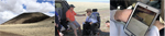 Figure
1
Figure
1
The SP Crater cinder cone that was only accessible to half of the cohort (left), the group that remained
at the base used two-way radios (middle) and a Livestream video broadcast (right) to communicate with
students at the top of the cinder cone.
Technology used: Two-way radios, GoPro video cameras, iPad cameras, and Livestream app.
Accessibility: A physically inaccessible field site where several students remained with
the vehicles at the base of the mountain, while others climbed the mountain via the steep, loose-cinder
front, or a longer path around the back; communication was hindered by loss of line-of-sight and a
significant (1–2 min) delay in the Livestream video relay from the summit.
Western Ireland Field Sites, Year 2
Year 2 focused on field sites in western Ireland, where challenges to field access and participation were
very different from Arizona. Field sites in western Ireland were typically windy, cold, and often rainy.
The field exercises during the second year featured the same cohort of students and expanded on the
experiences of the previous year. Exercises were longer, more involved, and often incorporated different
technological solutions.
1. Kilkee, County Clare
This half-day exercise focused on describing and interpreting sedimentary structures and deformation
features in rocks exposed along seaside cliffs near the town of Kilkee (Fig. 2). Most of the features,
such as ripple marks, cross-beds, and soft-sediment deformation structures (Martinsen et al., 2008) were
viewable by all participants from a paved path along the top of the cliffs. Some smaller-scale features,
such as sand volcanoes and fault surfaces, required descending steps to an eroded cliff platform and
thus were not accessible to everyone. Students used iPad cameras and the Evernote and Skitch apps to
record, sketch, and describe features; remote communications were facilitated with two-way radios. A
full group discussion of the exercise occurred indoors later in the evening.
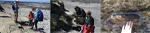 Figure
2
Figure
2
Students at the exposed seaside cliffs near Kilkee (left) using the camera and Skitch application on the
iPads (middle) to record and annotate the sedimentary structures and deformation features (right) to
share with their peers who did not access this location.
Technology used: iPad cameras, Evernote and Skitch apps.
Accessibility: Paved paths did not extend onto cliff exposures, which were only
accessible by stairs. Foot paths were narrow and steep in locations, inaccessible to wheelchair users.
High winds made group communications difficult.
2. Lough Derryclare, Connemara
This three-day exercise focused on bedrock mapping in a boggy field area along the southern shore of
Lough Derryclare in Connemara. Geological features included folded schists and quartzites of the
Connemara Dalradian sequence (Leake and Tanner, 1994). Outcrops along a gravel road were accessible to
all students; other outcrops required traversing boggy fields and were not accessible to students with
mobility disabilities. Cell signals in the area were weak and ineffective, so a local area network (LAN)
was set up to facilitate real-time communications between team members (see Network Connectivity
section). Students recorded field data (lithologic descriptions and orientation measurements) with the
FieldMove app in order to create a collaborative geologic map. Students with mobility disabilities
mapped outcrops along the gravel road, while mobile students mapped outcrops in more distant and less
accessible locations. Students communicated in real time via two-way radios and iPads using the AirBeam
app. Photos were shared in near real time with the PhotoSync app. Videos were recorded asynchronously
with GoPro cameras and shared between team members upon reconvening in common locations.
Technology used: Two-way radios, GoPro cameras, iPad cameras, FieldMove, AirBeam, and
PhotoSync apps, with real-time communications facilitated by a LAN.
Accessibility: Outcrops along the gravel road were accessible to all students; remote
outcrops were not accessible to students with mobility disabilities due to intervening uneven bogs.
Rainy and cold weather negatively impacted all participants.
3. Renvyle Point, County Galway
The coastal bluff at Renvyle Point consists of an ~15 m vertical exposure of glacial till that lies
unconformably on a wave cut platform of Dalradian Schist. The bluffs are not visible from the parking
area and can only be reached after descending an uneven field of beach cobbles and boulders (see
Supplemental Fig. SD2 [see footnote 1]). The half-day exercise focused on examining and interpreting
deformation and fluidized flow features within the glacial till in order to determine the movement of
the glacier. Due to the challenging terrain of the field area and the rainy weather, students with
mobility disabilities remained in the vehicles and collaborated with their peers using two-way radios
and iPads via a LAN.
Technology used: Two-way radios, GoPro cameras, iPad cameras, AirBeam and PhotoSync
apps; real-time communications and data exchange with iPads were facilitated by a LAN.
Accessibility: Exposures of glacial till were only accessible by climbing down large,
wet boulders along the shore. Rainy and windy weather made outdoor audio communications difficult.
Technology to Enhance Field Access and Inclusion
Synchronous and Asynchronous Communication
We used both synchronous (real-time sharing of audio or video) and asynchronous (delayed sharing) methods
of communication while in the field. Synchronous communications were facilitated by a cell network at SP
Crater to broadcast a video stream from the summit to students at the base of the hill. We used the
Livestream web broadcasting app, but the 1–2-minute delay between transmitting and receiving the video
stream made synchronous interactions between team members challenging. Students found the discrepancy
between the faster audio communications and the slower video transmissions awkward. Students ascending
the hill also used two-way radios for audio communications with team members at the base, which had no
time lag as long as line-of-sight was maintained. Two-way radios typically have a strong signal across
distances of 2–3 km and were frequently used by student teams when WiFi was not functional. In
locations where a LAN was available, the AirBeam app was used for synchronous video streaming, and
PhotoSync was used for photo sharing.
In field settings where cell signals or a LAN were not available, data sharing among participants across
field sites was accomplished with asynchronous methods, although real-time communication could still be
accomplished with two-way radios. Participants asynchronously recorded video with GoPro or iPad cameras
and collected field data with a variety of iPad apps. Data were shared when participants were once again
in close proximity. Once a cell or WiFi signal was available, participants uploaded their field data to
Dropbox so that others could view and download it.
Network Connectivity
The level of connectivity between participants distributed across a field site can determine the degree
of synchronicity available for interactions. Typically, cable or fiber connections are not practical in
the field, cell network coverage can be unreliable, and satellite connections are expensive. A more
manageable communications solution is to “bring your own network” to the field in the form of a LAN
using battery-powered outdoor WiFi routers. The local topography, and the distribution and mobility of
students across the site, affects the number of routers required to provide effective connectivity.
Panel and omni-directional antennas are used to target the WiFi signal in a directed beam or over a
local area (respectively) and moved as needed to maintain coverage across the site. The routers are
configured as access points, providing connectivity for local devices, or in a chain of point-to-point
links to connect field site locations (Collins et al., 2010). Some knowledge of computer networking is
required, but once configured, a LAN can be used flexibly in a range of field scenarios.
The LAN was used at the Lough Derryclare and Renvyle Point field sites to stream video between iPads
using the AirBeam app and share photos using the Photosync app. At Lough Derryclare, as students were
distributed across the field site, up to six WiFi routers were used in a network as line-of-sight signal
repeaters to maintain connectivity across the rough and hilly terrain. This configuration provided
network coverage of up to two square kilometers of the field area. At Renvyle Point, access points were
used at the two student locations (the car park and shoreline) connected by a 40-m network cable.
iPad Apps
Fieldwork activities were supported through a range of iPad apps (see Supplemental Table SD1 [see
footnote 1]). Photos and videos were captured asynchronously using iPad or GoPro cameras. Photos were
shared with the PhotoSync app, and synchronous video feeds were attempted with the Livestream and
AirBeam apps. Field notes and students’ reflections were recorded using the Notes, Evernote, or
Notability apps, and photos were annotated with the Skitch app. Orientation measurements were collected
and geologic maps were constructed using the FieldMove app. Two apps were used to construct
stratigraphic sections: StratLogger was used in year one, and Strat Mobile was used at PEFO (see
Atchison et al., 2019b). Dropbox was used to share files among participants and between the iPads when
connected to the Internet. Flyover Country was used on the PEFO field trip to bring geologic maps and
information into the field as reference materials. Many of these field mapping and data collection
applications can now be accomplished with the StraboSpot app and database system (Walker et al., 2019).
However, that was not available to us during the period that we conducted the project exercises.
Discussion
The primary objective of this project was to determine ways to enhance collaboration across instructional
activities in field sites with limited accessibility. Challenging terrain and changing environmental
conditions impacted participation in field activities across a spectrum of physical abilities. We
attempted to mitigate the issues of accessibility in field-based teaching and learning through the
integration of technology and collaborative strategies that promote full inclusion. The sociotechnical
solutions highlighted in this paper resulted from the usability of mobile technologies, levels of social
and academic engagement, and environmental conditions.
Inclusion and Accessibility
Accessibility and inclusion are not synonymous terms but are often used as such (Carabajal and Atchison,
2020). In this project, accessibility and inclusion were both partially addressed through the use of
technology. Participants with disabilities achieved better access to less-accessible field sites through
photo and video imagery from peers and colleagues and imagery from apps such as FieldMove and Flyover
Country. Inclusion, however, deals with the group dynamic, social engagement, and collaborative nature
inherent in most field activities. The use of technology in this sense enables participants to
collaborate through real-time video and photo sharing and two-way radios to share observations and
interpretations with peers and colleagues. The opportunity for the entire learning community to draw
from multiple perspectives of an individual field site (close-up, from a distance, through aerial
imagery), including the ability to discuss disparate observations across distances for the purpose of
developing collective interpretations, strengthened the overall understanding of the entire group (see
Atchison et al., 2019a).
Inclusive Collaboration through Technology
We addressed data collection and communication in the field with both synchronous (real-time
connectivity) and asynchronous (delayed) solutions. In many situations, asynchronous solutions were used
as a backup when real-time solutions were ineffective—such as the time delay (buffering delay) between
broadcast and reception when using the Livestream app at SP Crater, or when a WiFi network was
unavailable (e.g., Kilkee). In the discussion of technology that follows we consider both successful and
less successful solutions, in the hope that others can make use of, and expand on, our experiences.
Geologic Mapping and Data Collection
We used the StratLogger app for the ToT exercise at the Grand Canyon to record lithologic and
stratigraphic data. After an introduction to using the app, students were fairly efficient in recording
data and building their stratigraphic columns. We switched to the Strat Mobile app for the PEFO field
trip after we found that StratLogger did not work with the latest operating system of the iPads. Often,
the most effective software for geoscience fieldwork is developed by tech-savvy geoscientists, but it
can be a challenge for geoscientist developers to keep their software compatible with continuous updates
to operating systems. Commercial software solutions are usually up-to-date with operating systems but
are often less effective for specialized field tasks.
We used the FieldMove app for geologic mapping in the field. FieldMove includes a digital compass that
records orientation measurements and plots them in real time on a basemap of the area (road map, terrain
map, or aerial photo). Alternatively, a hand-held compass can be used to take measurements and entered
manually in FieldMove. Concerns have been expressed about the accuracy and precision of measurements
taken by digital compasses. However, recent analyses suggest that digital compasses, such as those in
FieldMove, can produce results at a similar level of accuracy and precision as analog compasses, as long
as the digital compass is calibrated correctly (Novakova and Pavlis, 2017; Whitmeyer et al., 2019). We
noted an advantage to using the iPads for measurements when several of the students with mobility
disabilities had difficulty getting close enough to utilize a handheld compass on an outcrop surface.
Field geologists who predate the mobile technology revolution are accustomed to using paper field books
for notes and sketches, and often find note-taking apps for mobile devices less intuitive to use.
However, students who are accustomed to using mobile devices for communications and social interactions
easily adapted to using apps like Notability, Evernote, and Skitch to record field observations.
Students appreciated the capability of these apps to import pictures taken with the iPad cameras, making
it easy to associate field photos with text annotations and explanations, and to draw interpretive
sketches on photos.
Another advantage of mobile devices is the ability to preload data and maps on the device for later
asynchronous use. Mapping apps like FieldMove allow users to preload georeferenced aerial photos or
topographic base-maps for fieldwork. Geologic reference data and information can be preloaded on iPads
with an app like Flyover Country. We used this app to load state-level geologic maps and information for
southern and eastern Arizona for our journey from Phoenix to Holbrook during the PEFO field trip. This
provided participants with background geologic and cultural information for reference as they traveled
through a region of interest.
Audio and Video Communications in the Field
We experimented with video broadcasting apps that were less successful (e.g., Livestream), prior to
settling on the AirBeam app for video streaming with a LAN. This facilitated video communications among
team members with a minimal delay (<5 seconds). At both the Lough Derryclare and Renvyle Point field
sites, students with mobility disabilities found that video communications with their partners provided
a level of accessibility to remote outcrops that would not have been possible without the technology. In
some situations, near real-time transfer of photos and still images between team members effectively
substituted for video communications. Where weather or connectivity challenges precluded effective video
links, students used the PhotoSync app to share still images and discussed the geologic features in the
photos using two-way radios.
Even with our attempts to secure robust wireless signals for real-time communications, we still
encountered many situations where asynchronous methods of data collection were necessary. Students
always had the option of taking photos or recording videos using the iPad’s native camera, which could
be shared with their team members at a later time. GoPro wearable video cameras were extensively used to
record traverses across a field area and to highlight important geologic features. Photos and recorded
videos served as important field data that were used to both complete field exercises and to document
field experiences.
Facilitating Connectivity in the Field
As with any field equipment, there is a degree of contingency planning needed when introducing mobile
technology. Most crucial is the time taken to set up equipment in the field or fix problems that could
impact students’ learning experiences. Pre-configuring the LAN (e.g., connecting the routers, testing
them, and packing them ready for deployment) helps minimize the setup time in the field. Knowledge of
the field sites and the activities at each site is crucial to ensure that network coverage is sufficient
(while minimizing redundancy). Revisiting known sites enables the re-use and rapid deployment of
effective technology configurations. Bringing spares of essential components (e.g., batteries, cables)
into the field enables faulty equipment to be easily replaced. Also important is to prepare alternate
resources (e.g., two-way radios) and activities to be used in the case of technology failure.
Effective use of a LAN in larger field areas usually requires the services of a field technology expert.
The expert not only configures the network, but also tests it and deploys it in the field prior to the
arrival of students. Invariably, unforeseen challenges occur during a field session, and it is essential
to have the tech expert available in the field to troubleshoot problems that develop. We often used
two-way radios for communication between participants and the expert in order to resolve issues. Some
technological challenges were not solvable in the field and necessitated the development of new
solutions after returning from the field in order to mitigate future problems.
Student Engagement
This study was initially focused on evaluating learning outcomes related to geoscience field content, but
soon expanded to identify overall collaborative inclusion and engagement of field activities in sites
with limited physical accessibility. Engagement and overall enjoyment were palpable, mostly because a
geoscience field study of this kind, which included multiple students with similar physical
disabilities, was designed specifically to address student needs. All students realized they were part
of a foundational study to enhance access to field learning and were aware that their personal
well-being was considered in the design. The study remained flexible to enable their voices to drive the
direction of the activities, especially when unavoidable changes in environmental conditions (e.g.,
daily weather) caused us to reevaluate our plans. Taken as a whole, students were not used to having an
opportunity that was meant to include them, their strengths and abilities, which undoubtedly impacted
overall engagement and enjoyment. However, not everything was enjoyable and engaging all of the time.
The students without disabilities, who generally had more field experience than their disabled peers,
were often left feeling as if they were only being used to collect data in sites that their colleagues
could not access. Additionally, switching between technologies that were new to most of the students,
and the occasional lag-time between audio communication and photo/video sharing, negatively impacted
engagement and collaborative outcomes overall.
Conclusions and Implications
The integration of mobile communication and data collection technologies can have a positive impact on
teaching and learning in field-based activities. Increased collaborative engagement and social inclusion
in the learning community is achievable, even when students are separated across field sites with
variable accessibility. Real-time communication between groups enables data sharing, shared
observations, and interpretations that are not commonly done when working groups are separated. This
social inclusion and collaboration is important because it gives students ownership in the learning
environment. However, the integration of technology can introduce additional challenges to the student
field experience. Students often have varying levels of field experience, geology content knowledge, and
comfort with using technology to collect data and communicate. Varying levels of confidence in the use
of mobile technologies can amplify anxiety and develop an unwelcome stratified community of learning
within the group.
Not everything we tried was successful, but even the small failures drove the evolution of the project
through a constant attempt to overcome physical barriers to field-based teaching and learning. Outcomes
of the project that demonstrate how technology can be used to enhance access to field sites and increase
collaborative inclusion across all participants during field exercises include:
1. The inherent flexibility of digital tools recognizes diversity and enables personal choice (i.e.,
fieldwork does not have to be restrictive).
2. Specialized field apps are typically the best solutions for geoscience fieldwork but are often
developed by domain specialists and not always well maintained.
3. Always have contingency plans—technologies and strategies can fail for a variety of reasons, so have
back-up equipment and alternate options (e.g., asynchronous can succeed when synchronous fails).
4. Be prepared—preconfigure the technology and ensure that everyone knows how to use it before going into
the field. Know how to get help when things go wrong.
5. Ensure you have adequate resources—fieldwork is unpredictable, so make sure you have the expertise to
adapt (especially when technology is involved).
We have discussed our experiences with this exploratory pilot study, encompassing both successes and
challenges, and some possible strategies for implementing the use of mobile technologies for enhanced
fieldwork. Expanding the scope of our approaches will require a significant change in how most of us
conduct research and education in the field. Doing so would not only provide improved experiences for
students, but also would enhance the pedagogic toolkit available to field instructors. We envision the
next phase of this work as focusing on the geoscience community as a whole, to expand the outcomes of
this work and develop new strategies to make multi-day and residential field experiences accessible and
inclusive of all geoscientists. In addition, now that we have identified the capabilities and potential
of using various mobile technologies to increase access and engagement in a field-based inclusive
learning community, we recognize the need to align the content of inclusive field experiences to typical
field-camp learning objectives (e.g., collecting accurate data in the field, synthesizing data to create
geologic map interpretations, synthesizing field data and interpretations to write a summary of the
geologic history, among others). Evaluation of the effectiveness of the methods discussed in this paper
against student learning outcomes will indicate the utility of these methods.
Acknowledgments
The authors acknowledge helpful reviews by Randy Williams and an anonymous reviewer and comments from
editor Mihai Ducea. The authors would like to acknowledge student and faculty participants, as well as
the members of the project team: Declan De Paor, Eric Pyle, Jennifer Piatek, Susan Eriksson, Martin
Feely, Helen Crompton, Anita Marshall, and Ivan Carabajal. This work was supported by NSF award
#1540652. Any opinion, findings, and conclusions or recommendations expressed in this material are those
of the authors and do not necessarily reflect the views of the National Science Foundation.
References Cited
- Allmendinger, R.W., Siron, C.R., and Scott, C.P., 2017, Structural data collection with mobile
devices: Accuracy, redundancy, and best practices: Journal of Structural Geology, v. 102,
p. 98–112, https://doi.org/10.1016/j.jsg.2017.07.011.
- Atchison, C., Marshall, A., and Collins, T., 2019a, A multiple case study of inclusive learning
communities enabling active participation in geoscience field courses for students with physical
disabilities: Journal of Geoscience Education, v. 67, no. 4, p. 472–486,
https://doi.org/10.1080/10899995.2019.1600962.
- Atchison, C., Parker, W., Riggs, N., Semken, S., and Whitmeyer, S., 2019b, Accessibility and
inclusion in the field: A field guide for central Arizona and Petrified Forest National Park, in
Pearthree, P.A., ed., Geologic Excursions in Southwestern North America: Geological Society of
America Field Guide 55, p. 39–60, https://doi.org/10.1130/2019.0055(02).
- Carabajal, I.G., and Atchison, C.L., 2020, An investigation of accessible and inclusive
instructional field practices in U.S. geoscience departments, in de Jesus Rydin, P.C., Richardson,
K., Karsten, J., and Oguchi, C., eds., Diversity and Equality in the Geosciences, Advances in
Geosciences: European Geophysical Union, v. 1, p. 1–11,
https://doi.org/10.5194/adgeo-1-1-2020.
- Collins, T., 2015, Enhancing outdoor learning through participatory design and development: A case
study of embedding mobile learning at a field study centre: International Journal of Mobile Human
Computer Interaction, v. 7, no. 1, p. 42–58,
https://doi.org/10.4018/ijmhci.2015010103.
- Collins, T., Gaved, M., and Lea, J., 2010, Remote fieldwork: Using portable wireless networks and
backhaul links to participate remotely in fieldwork, in The Proceedings of the 9th World Conference
on Mobile and Contextual Learning (mlearn 2010), 19–22 Oct 2010, Valletta, Malta,
https://core.ac.uk/download/pdf/16852.pdf (accessed 18 June 2020).
- Collins, T., Davies, S.J., and Gaved, M., 2016, Enabling remote activity: Widening participation in
field study courses, in Kennepohl, D., ed., Teaching Science Online: Practical Guidance for
Effective Instruction and Lab Work: Sterling, Virginia, USA, Stylus Publishing, p. 183–195.
- Coughlan, T., Adams, A., Collins, T., Davies, S.J., Lea, J., and Rogers, Y., 2011, Working with
‘mission control’ in scientific fieldwork: Supporting interactions between in situ and distanced
collaborators, in The 2011 ACM Conference on Computer Supported Cooperative Work, 19–23 Mar 2011,
Hangzhou, China, http://oro.open.ac.uk/26139/ (accessed 18 June 2020).
- Dohms, P., 2011, Education and training of geologists; is field camp still relevant?: Professional
Geologist, v. 48, p. 12–14.
- Drummond, C., 2001, Can field camps survive?: Journal of Geoscience Education, v. 49,
no. 4, p. 336.
- Feig, A.D., 2010, Technology, accuracy and scientific thought in field camp: An ethnographic study:
Journal of Geoscience Education, v. 58, no. 4, p. 241–251,
https://doi.org/10.5408/1.3534863.
- France, D., Whalley, W.B., Mauchline, A., Powell, V., Welsh, K., Lerczak, A., Park, J., and Bednarz,
R.S., 2015, Enhancing Fieldwork Learning Using Mobile Technologies: Berlin, Springer, 176 p.,
https://doi.org/10.1007/978-3-319-20967-8.
- Hall, T., Healey, M., and Harrison, M., 2002, Fieldwork and disabled students: Discourses of
exclusion and inclusion: Transactions of the Institute of British Geographers, v. 27,
p. 213–231, https://doi.org/10.1111/1475-5661.00050.
- Healey, M., Jenkins, A., Leach, J., and Roberts, C., 2001, Issues in Providing Learning Support for
Disabled Students Undertaking Fieldwork and Related Activities, in Gravestock, P., and Healey, M.,
eds.: http://gdn.glos.ac.uk/disabil/overview/overview.pdf (accessed 18 June 2020).
- Karlstrom, K., Semken, S., Crossey, L., Perry, D., Gyllenhaal, E.D., Dodick, J., Williams, M.,
Hellmich-Bryan, J., Crow, R., Bueno Watts, N., and Ault, C., 2008, Informal geoscience education on
a grand scale: The Trail of Time exhibition at Grand Canyon: Journal of Geoscience Education,
v. 56, no. 4, p. 354–361, https://doi.org/10.5408/informal_geoscience_education_.
- Kelley, D.F., Sumrall, J.L., and Sumrall, J.B., 2015, Student-designed mapping project as part of a
geology field camp: Journal of Geoscience Education, v. 63, p. 198–209,
https://doi.org/10.5408/14-003.1.
- Kirchner, J.G., 1994, Results of an alumni survey on professional and personal growth at field camp:
Journal of Geological Education, v. 42, no. 2, p. 125–128,
https://doi.org/10.5408/0022-1368-42.2.125.
- Leake, B.E., and Tanner, P.W.G., 1994, The Geology of the Dalradian and Associated Rocks of
Connemara, Western Ireland, Special Publication: Dublin, Ireland, Royal Irish Academy, 96 p., ISBN
1-874045-18-6.
- Maguire, S., 1998, Gender differences in attitudes to undergraduate fieldwork: Area, v. 30,
no. 3, p. 207–214, https://doi.org/10.1111/j.1475-4762.1998.tb00065.x.
- Martinsen, O.J., Sullivan, M., Pulham, A., Haughton, P., Harper, H., and Elliott, T., 2008, Outcrops
Revitalized: Tools, Techniques and Applications: Kilkee, County Clare, Ireland, 22–27 June, SEPM
Research Conference, p. 1–58.
- Maskall, J., and Stokes, A., 2009, Designing Effective Fieldwork for the Environmental and Natural
Sciences: Plymouth, UK, Higher Education Academy Subject Centre for Geography, Earth and
Environmental Sciences,
https://www.advance-he.ac.uk/knowledge-hub/designing-effective-fieldwork-environmental-and-natural-sciences
(accessed 19 June 2020).
- Mogk, D.W., and Goodwin, C., 2012, Learning in the field: Synthesis of research on thinking and
learning in the geosciences, in Kastens, K.A., and Manduca, C.A., eds., Earth and Mind II: A
Synthesis of Research on Thinking and Learning in the Geosciences: Geological Society of America
Special Paper 486, p. 131–163, https://doi.org/10.1130/2012.2486(24).
- Novakova, L., and Pavlis, T.L., 2017, Assessment of the precision of smart phones and tablets for
measurement of planar orientations: A case study: Journal of Structural Geology, v. 97,
p. 93–103, https://doi.org/10.1016/j.jsg.2017.02.015.
- Pavlis, T.L., Langford, R., Hurtado, J., and Serpa, L., 2010, Computer-based data acquisition and
visualization systems in field geology: Results from 12 years of experimentation and future
potential: Geosphere, v. 6, p. 275–294, https://doi.org/10.1130/GES00503.S2.
- Stokes, A., Collins, T., Maskall, J., Lea, J., Lunt, P., and Davies, S.J., 2012, Enabling remote
access to fieldwork: Gaining insight into the pedagogic effectiveness of ‘direct’ and ‘remote’ field
activities: Journal of Geography in Higher Education, v. 36, no. 2, p. 197–222,
https://doi.org/10.1080/03098265.2011.619004.
- Stokes, A., Feig, A.D., Atchison, C.L., and Gilley, B., 2019, Making geoscience fieldwork inclusive
and accessible for students with disabilities: Geosphere, v. 15, no. 6, p. 1809–1825,
https://doi.org/10.1130/GES02006.1.
- Ulrich, G.E., 1987, SP Mountain cinder cone and lava flow, northern Arizona: Geological Society of
America Centennial Field Guide, Rocky Mountain Section, p. 385–388,
https://doi.org/10.1130/0-8137-5402-X.385.
- Walker, J.D., Tikoff, B., Newman, J., Clark, R., Ash, J., Good, J., Bunse, E.G., Moller, A., Kahn,
M., Williams, R.T., Michels, Z., Andrew, J.E., and Rufledt, C., 2019, StraboSpot data system for
structural geology: Geosphere, v. 15, https://doi.org/10.1130/GES02039.1.
- Whitmeyer, S.J., Pyle, E.J., Pavlis, T.L., Swanger, W., and Roberts, L., 2019, Modern approaches to
field data collection and mapping: Digital methods, crowdsourcing, and the future of statistical
analyses: Journal of Structural Geology, v. 125, p. 29–40,
https://doi.org/10.1016/j.jsg.2018.06.023.