Introduction
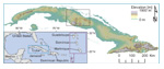
The Republic of Cuba (Fig. 1) has more than 11 million inhabitants, but there has been little
collaboration between U.S. and Cuban scientists for more than half a century although only 160 km
separates the two countries (Feder, 2018). River biogeochemistry data, which are sparse in tropical
regions, are needed to guide sustainable development in Cuba and, by example, in other tropical and
island nations.
 Figure
1
Figure
1
Cuba with elevation as color ramp. Black outline is area mapped in Figure 3. Inset shows location of
Cuba in relation to North America.
Here, we present and interpret extensive new data characterizing river waters in central Cuba, the result
of a bi-national, collaborative field campaign. Biogeochemical analyses allow us to address fundamental
geologic questions, such as the pace of chemical weathering in the tropics, as well as applied
environmental questions related to the quality of river water and human impacts on a landscape where
small-scale, sustainable farming has replaced substantial swaths of industrial agriculture (The
Guardian, 2017).
Background and Methods
Cuba’s wet, warm tropical landscape is dominated by mountains (up to 1917 m above sea level [asl] in the
east, 500–700 m asl elsewhere) running parallel to the north and south coasts (Fig. 1). Mainly forested
uplands descend into farmed rolling plains and mangrove-lined, low-lying coastal estuaries. The climate
is summer-wet and winter-dry with precipitation delivered both by trade-wind showers and by larger
tropical storms.
The diverse geology of Cuba reflects its tectonic setting at the boundary of the North America and
Caribbean plates. Central Cuban basement lithologies include accreted igneous rocks, sediments (clastic,
carbonate, and evaporite) formed along passive margins, obducted ophiolite, and island arc rocks
(Iturralde-Vinent et al., 2016). This basement is unconformably overlain by slightly deformed, younger
marine and terrestrial sedimentary rocks (Iturralde-Vinent, 1994). Where river water has interacted with
these diverse rocks, surface water chemistries should reflect the composition of underlying rock units.
Agriculture has been practiced in Cuba for centuries. Indigenous people cultivated cassava, yucca, and
maize (Cosculluela, 1946). Spanish colonization from 1492 brought slaves, large-scale sugar agriculture,
and cattle farming (Zepeda, 2003). Following Cuba’s independence from Spain in 1898, sugar production in
Cuba quadrupled under U.S. influence (Whitbeck, 1922). When Cuba allied with the Soviet Union in 1959,
industrialization of the sugar industry to increase yields and exports became a central goal
(Pérez-López, 1989). By the 1980s, Cuba boasted the most mechanized agricultural sector in Latin America
(Febles-González et al., 2011); however, the collapse of the Soviet Union in 1991 catalyzed Cuban
adoption of reduced tillage, organic soil amendments, the use of cover crops, and the replacement of
fuel-hungry tractors with domesticated draft animals, including horses and oxen (Gersper et al., 1993).
Surface water biogeochemical monitoring in central Cuba has focused mainly on reservoirs. In central
Cuba, water chemistry data (1986–2005) from four reservoirs, representing two river systems and four
basins with varied geology (Betancourt et al., 2012) showed that the primary control on major ion
concentration is rock weathering upstream; there was no statistically significant difference in water
chemistry between dry and rainy seasons in three of the four basins.
In August 2018 (the wet season), we collected water samples from 25 river basins in central Cuba. We
selected these sites to encompass a range of land uses, underlying upstream rock types, discharges, and
basin sizes, while avoiding rivers that had major dams (Figs. 2 and 3N). See the GSA Data
Repository1 for detailed methods. Our analysis assumes that the concentration of cations and
anions we measured are representative of annual average values (Godsey et al., 2009).
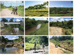 Figure
2
Figure
2
Common Cuban landscapes and example sample sites. (A) Sugarcane and dirt roads are common on the island.
(B) Cattle grazing on cleared fields. (C) Citrus groves on slopes in southern field area. (D) Horses
were frequently in rivers, CU-132. (E) Plane-bed sand and gravel channel with cows in the river, CU-101.
(F) Large point bar flooded during Hurricane Alberto showing dynamic range of river flows over time,
CU-114. (G) Boulder/bedrock channel during conductivity measurement, CU-115. (H) Bedrock channel,
CU-114. (I) Low flow sample site in incised channel, CU-122. Locations identified by letter in Figure
3N.
 Figure
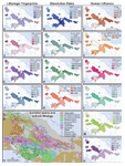
3
Figure
3
Results of river water biogeochemical analyses plotted for 25 sampled basins. (A) Chloride. (B) Mean
annual precipitation. (C) Percent agricultural land use. (D) Sulfate. (E) Conductivity. (F)
E.
coli. (G) Bicarbonate. (H) Total dissolved solids. (I) Total dissolved nitrogen. (J) Silica.
(K) Chemical denudation rate. (L) Orthophosphate as phosphorus. (M) Potassium. (N) Sampled basins
overlain on generalized geological map (French and Schenk, 2004). Letters show location of photos in
Figure 2. Four basins (CU-120, -121, -122, and -132 labeled with red text and points) have distinct
water chemistry. Dots represent sample sites. Stars shows reservoir water samples (Betancourt et al.,
2012). (O) Dissolved organic carbon.
Results
River water samples from central Cuba contain high concentrations of dissolved material (Figs. 3 and 4).
Conductivity and total dissolved load were high (130–1380 μS/cm and 117 to over 780 mg/L, respectively,
Tables S1 and S2 [see footnote 1]); stream water, except that sampled from forested catchments, was
turbid. Sample pH was near neutral to slightly alkaline with high values of bicarbonate alkalinity
(65–400 mg/L). As, Ba, Cr, Mn, Ni, Sr, and U were present in some or all of the Cuban river waters we
analyzed, in all cases at levels below drinking water standards (Table S3 [see footnote 1]). Dissolved
oxygen measured in the field ranged from 59% to 145% (average 97%). Using basin-specific precipitation
(Fig. 3), along with run-off estimates (Beck et al., 2015, 2017) and total dissolved solids (TDS) from
each Cuban water sample, we estimate chemical weathering rates between 42 and 302 t km–2
y–1 with a mean of 161 ± 66 t km–2 y–1.
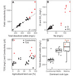 Figure
4
Figure
4
Rock type influences river water chemistry. Red symbols indicate basins with distinct water chemistry
highlighted in Figures 3 and 5. (A) Total dissolved solids (TDS) and field conductivity are well
correlated. (B) Positive correlation of Na with SO
4 and Cl suggests evaporite source of these
solutes. (C) No correlation between percent basin area used for agriculture and total dissolved solids
or conductivity. (D) Basins underlain by marine and mafic rocks have higher river water TDS.
Dissolved organic carbon (DOC) was highly variable, ranging from <1 mg/L to 9 mg/L (Table S4 [see
footnote 1]). Total dissolved nitrogen (TDN) ranged from <0.1–1.5 mg/L (mean = 0.76 mg/L); on average
60% was present as nitrate (range 24%–93%). Nitrate values measured in the field and then in the lab
several weeks later are well correlated. Nitrite was present in all samples, averaging 1.2 mg/L (0.37
mg/L of N). DOC/TDN ratios also vary widely, from 1.3 to 14.8. Anion concentrations decreased in the
order HCO3 > Cl > SO4 > NO3 > HPO4 >
NO2 > Br > F.
The anion orthophosphate (as P) was measured both in the field (0.1–0.8 mg/L) and lab (0.4–0.5 mg/L);
field and lab analyses were positively correlated. Cations decreased on average in the order Ca > Na
> Mg > Si > K.
E. coli bacteria were found in all samples, and most samples (20/24) contained enough bacteria
to be deemed unsafe for recreational use according to World Health Organization criteria (Most Probable
Number (MPN) > 127/100 ml). Genetic microbial source tracing in two samples with MPN/100ml >1000
(CU-107 and 110) did not identify any human-sourced bacteria; rather, the bacteria in sample CU-110 were
identified as being of ungulate origin, and no specific source could be determined for bacteria in
CU-107.
There are numerous correlations between anions and cations in our river water samples (Table S5 [see
footnote 1]). Na and Cl are positively correlated (p < 0.01) as well as Na and HCO3, F,
SO4, NO2, K, Ca, Br, Ti, As, Rb, Sr, Ba, and U (p < 0.05, all positive, Fig.
4). These elements are also correlated to one another positively and significantly. In addition, Mg is
positively correlated to SiO2, V, Cr, and Ni (p < 0.05). NO2 is positively
correlated with conductivity.
Four of the 25 samples (CU-120, -121, -122, and -132), all collected in the northwestern part of the
field area, are geochemically distinct (Figs. 3, 4, and 5). These samples have the highest or nearly
highest Cl, SO4, Br, NO2, and Na concentrations, field conductivity, and TDS (Fig.
4, red symbols) in the sample set. These are four of only five samples to contain low but measurable As
(1.0–1.4 ppb). They plot in a distinct zone of the Piper diagram (Fig. 5) and also have higher Rb, Sr,
Ba, and U concentrations (1.8–4.3 ppb) than other Cuban river water samples. Three of the four samples
contain >115 mg/L Ca and high concentrations of Na, Cl, and SO4. These four samples were
collected near one another and drain the same bedrock map unit (post-Eocene marine sediment). One
(CU-122) drains mostly wetland while the others drain dominantly agricultural catchments.
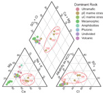 Figure
5
Figure
5
Piper diagram of all data color-coded by mapped lithology (Fig. 3) (French and Schenk, 2004). Numbered
samples are those with distinct water chemistry influenced by evaporite rocks.
Discussion/Interpretation
Bedrock Controls Central Cuban River Water Chemistry
In central Cuba, river water composition and TDS covary with rock types (Figs. 3 and 4D) suggesting a
close connection between river water chemistry and underlying rock units. For example, high
concentrations of Ca, Mg, and alkalinity in most samples are consistent with the mapped presence of
carbonate rocks in most sampled drainage basins (Fig. 3). Distinct anion, cation, and trace metal
compositions of rivers draining four (CU-120, -121, -122, -132) watersheds in the NW quadrant of our
field area and underlain by marine sediments (French and Schenk, 2004) suggest dissolution of evaporite
deposits including those that contain nitrite (Figs. 3, 4, and 5).
The relationship between water chemistry and bedrock type in central Cuba suggests the presence of fresh,
weatherable mineral surfaces along flow paths carrying subsurface flow to Cuban rivers. This inference
is supported by comparison of Cuban river water chemistry with that from Martinique, Guadeloupe, and
Dominica (Rad et al., 2013). The latter three islands are underlain primarily by andesite, and their
surface water contains more Si and K and less Ca and Mg than Cuban rivers (Fig. 6A). The higher
concentration of most other anions and cations in Cuban waters as compared to waters from volcanic
Caribbean islands reflects the influence of readily soluble carbonate and evaporite rocks in Cuba.
Although average TDS for waters from Cuba exceeds that on other, e.g., volcanic, Caribbean islands (Fig.
6A), chemical denudation rates estimated from central Cuban river water samples are similar to other
Caribbean islands (Fig. 6B) because mean annual precipitation and thus runoff in Cuba is lower. All
Caribbean chemical denudation rates are high when compared to global data (Larsen et al., 2014).
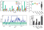 Figure
6
Figure
6
Cuban river water data in context. (A) Cuban waters contain greater dissolved concentrations for most
elements or ions than other Caribbean islands (Rad et al., 2013). (B) Chemical weathering rates
(cations, anions, and Si) in rivers sampled in central Cuba, Dominica, Guadeloupe, and Martinique (Rad
et al., 2013) are high and similar (cf. global from Larsen et al. [2014];
n = 299). Note log
scale. Median is middle line, the 25th and 75th percentiles are the edges, and whiskers extend to
include all samples within 1.5 times the range of the box. (C) Total dissolved nitrogen (TDN) for
Mississippi River at Baton Rouge (water.usgs.gov) compared to central Cuban rivers (this paper). (D)
Cuban fertilizer use (P, K, N) normalized by arable land area is stable and less than other nations.
Data from
https://data.worldbank.org/indicator/, Rawlins et al. (1998), and
https://www.epa.gov/roe/.
Field observations of incised, bedrock-floored river channels and the chemical data that mandate
extensive water/rock interaction similar to that on tectonically active, volcanic Caribbean islands
suggest ongoing bedrock uplift in central Cuba rather than tectonic stability and the development of a
deep tropical weathering mantle. Raised marine terraces along southern and eastern Cuba (Muhs et al.,
2017) are consistent with such uplift, which, along with tectonically induced rock fracturing, is likely
responsible for the continued supply of fresh, easily weatherable rock, and thus high chemical
weathering rates.
Human Activities and Water Quality
High TDS in central Cuban river water as a result of bedrock chemical weathering is not hazardous but
could limit some uses. About 20% of samples we collected have TDS and Na levels above the taste
threshold. High TDS samples may cause CaCO3 scaling on pipes, household cooking implements,
and industrial equipment; scaling could be a health benefit if lead remains in the water distribution
system. High levels of DOC (up to 9 mg/L) in central Cuban river water suggest a potential risk of
trihalomethane formation during chlorination (Engelage et al., 2009), which is the most frequently used
water treatment technique in Cuba (Cueto and De Leon, 2010).
Bacterial contamination of river water in central Cuba is consistent with the nearly ubiquitous presence
of livestock on the landscape, perhaps because animals have in part replaced fossil-fuel–powered
transportation and farm equipment (Fig. 3). We do not know the source of the detected E. coli;
however, the ungulate match in one of two samples we tested is consistent with numerous cows we observed
walking in and around rivers as well as extensive pastures near and upstream of many sampling sites.
High levels of E. coli are found in rivers around the world. Data from other Caribbean islands,
including Martinique, Trinidad, and Puerto Rico, show similarly high E. coli levels in river,
spring, and coastal waters (Bachoon et al., 2010; Pommepuy et al., 2000; Wampler and Sisson, 2011).
E. coli levels above health advisory levels are routinely measured in Vermont river water, a
similarly agricultural state with more than a quarter million cows, only half the stocking density per
area of Cuba (Riera, 1994). Although pigs and chickens were common in central Cuba, we did not see them
near rivers, which may explain why tests for fecal matter from these animals were negative as were those
for human fecal bacteria.
Central Cuban river waters provide evidence that agriculture need not overload rivers, and thus
reservoirs and coastal zones, with nutrients. N and P are present in Cuban river waters, but at lower
concentrations than in the United States, where agriculture is intensive and fertilizer use is heavy
(Fig. 6). Total dissolved nitrogen in central Cuban river water is <50% of the Mississippi River
average and <25% of peak Mississippi River concentrations (Fig. 6C). Cuban waters have only slightly
more TDN than less agricultural Caribbean volcanic islands (Rad et al., 2013).
The history of fertilizer use over time is telling (Fig. 6D). Cuban fertilizer use peaked in 1978 and
then declined, whereas fertilizer use in the United States rose after 1961 and has remained high, more
than twice the area-normalized value as Cuba. Sustainable agricultural initiatives, implemented in Cuba
after the end of Soviet assistance, have resulted in less fertilizer use and better river water quality
(Fig. 6). The result is far less downstream transport and loading of nutrients into coastal waters,
nutrients that can have a profound and negative effect, including the presence of anoxic, marine dead
zones (Obenour et al., 2013).
Implications
Our data provide a comprehensive snapshot of the chemistry of water moving through rivers in central
Cuba. From these data, we calculate high rates of rock weathering and landscape-scale denudation and
thus infer the presence of flow paths through fresh rock or regolith supplying water to rivers we
sampled—perhaps in response to tectonic uplift. Cuba’s transition toward sustainable agriculture (and
its reduced use of fertilizer per acre of crop land) results in much lower river-water nutrient
concentrations in central Cuban rivers than in the Mississippi River—a model for other agricultural
economies. Additional management strategies to reduce manure and sediment loads to rivers (such as
fencing to keep cattle off river banks) could further and rapidly improve central Cuban river water
quality. Reducing sediment and manure loads will have economic benefits, because rivers eventually
discharge into the coastal zone where suspended sediment, and bacteria from agricultural activity,
impact water quality and clarity on coral reefs and beaches frequented by tourists (Rawlins et al.,
1998), a source of income to Cuba (Duffy and Kline, 2018).
Acknowledgments
Support for field and analytic work provided by NSF EAR-1719249 and NSF EAR-1719240 to Bierman and
Schmidt. Cuban researchers supported by the MICATIN and ISOAGRI projects. We thank W. Amidon, P. Ryan,
and J. Smith (Middlebury College) for ICP-MS data and J. Brown UVM for photography. Some field costs and
DNA tests supported by Oberlin College. We thank T. Dunne, B. McDowell, and students in University of
Vermont Geology 351 for feedback on earlier versions of the manuscript.
References Cited
- Bachoon, D.S., Markand, S., Otero, E., Perry, G., and Ramsubhag, A., 2010, Assessment of non-point
sources of fecal pollution in coastal waters of Puerto Rico and Trinidad: Marine Pollution Bulletin,
v. 60, no. 7, p. 1117–1121, https://doi.org/10.1016/j.marpolbul.2010.04.020.
- Beck, H.E., de Roo, A.D., and van Dijk, A.I.J.M., 2015, Global maps of streamflow characteristics
based on observations from several thousand catchments: Journal of Hydrometeorology, v. 16,
no. 4, p. 1478–1501, https://doi.org/10.1175/JHM-D-14-0155.1.
- Beck, H.E., Vergopolan, N., Pan, M., Levizzani, V., van Dijk, A.I.J.M., Weedon, G.P., Brocca, L.,
Pappenberger, F., Huffman, G.J., and Wood, E.F., 2017, Global-scale evaluation of 22 precipitation
datasets using gauge observations and hydrological modeling: Hydrology and Earth System Sciences,
v. 21, p. 6201–6217, https://doi.org/10.5194/hess-21-6201-2017.
- Betancourt, C., Suarez, R., and Jorge, F., 2012, Influence of natural and antropic processes on the
water quality in four Cuban reservoirs: Limnetica, v. 31, p. 193–204.
- Cosculluela, J.A., 1946, Prehistoric Cultures of Cuba: American Antiquity, v. 12, no. 1,
p. 10–18, https://doi.org/10.2307/275809.
- Cueto, J., and De Leon, O., 2010, Evaluation of Cuba’s water and watershed infrastructure: Annual
Meetings of the Association for the Study of the Cuban Economy Miami, Florida, https://www.ascecuba.org/asce_proceedings/appendix-b-evaluation-cubas-water-watershed-infraestructure-student-paper-presented-annual-meeting-not-included-printed-version-proceedings/
(accessed 7 Jan. 2020).
- Duffy, L., and Kline, C., 2018, Complexities of tourism planning and development in Cuba: Tourism
Planning & Development, v. 15, no. 3, p. 211–215, https://doi.org/10.1080/21568316.2018.1440830.
- Engelage, S., Stringfellow, W., and Letain, T., 2009, Disinfection byproduct formation potentials of
wetlands, agricultural drains, and rivers and the effect of biodegradation on trihalomethane
precursors: Journal of Environmental Quality, v. 38, p. 1901–1908, https://doi.org/10.2134/jeq2009.0015.
- Febles-González, J.M., Tolón-Becerra, A., Lastra-Bravo, X., and Acosta-Valdés, X., 2011, Cuban
agricultural policy in the last 25 years: From conventional to organic agriculture: Land Use Policy,
v. 28, p. 723–735, https://doi.org/10.1016/j.landusepol.2010.12.008.
- Feder, T., 2018, Physics in Cuba: Physics Today, v. 71, no. 3, p. 48–54, https://doi.org/10.1063/PT.3.3871.
- French, C.D., and Schenk, C.J., 2004, Map showing geology, oil, and gas fields, and geologic
provinces of the Caribbean Region: U.S. Geological Survey Open-File Report 97-470-K,
https://pubs.usgs.gov/of/1997/ofr-97-470/OF97-470K/ (accessed 7 Jan. 2020).
- Gersper, P.L., Rodríguez-Barbosa, C.S., and Orlando, L.F., 1993, Soil conservation in Cuba: A key to
the new model for agriculture: Agriculture and Human Values, v. 10, no. 3, p. 16–23,
https://doi.org/10.1007/BF02217835.
- Godsey, S.E., Kirchner, J.W., and Clow, D.W., 2009, Concentration-discharge relationships reflect
chemostatic characteristics of US catchments: Hydrological Processes, v. 23, no. 13,
p. 1844–1864, https://doi.org/10.1002/hyp.7315.
- Guardian, The, 2017, Organic or starve: Can Cuba’s new farming model provide food security?: The
Guardian, 28 Oct. 2017, https://www.theguardian
- .com/environment/2017/oct/28/organic-or-starve-can-cubas-new-farming-model-provide-food-security
(accessed 16 Dec. 2019).
- Iturralde-Vinent, M., 1994, Cuban geology: A new plate-tectonic synthesis: Journal of Petroleum
Geology, v. 17, no. 1, p. 39–69, https://doi.org/10.1111/j.1747-5457.1994.tb00113.x.
- Iturralde-Vinent, M., Garcia-Casco, A., Rojas-Agramonte, Y., Proenza, J., Murphy, J.B., and Stern,
B., 2016, The geology of Cuba: A brief overview and synthesis: GSA Today, v. 26, no. 10,
p. 4–10, https://doi.org/10.1130/GSATG296A.1.
- Larsen, I.J., Montgomery, D.R., and Greenberg, H.M., 2014, The contribution of mountains to global
denudation: Geology, v. 42, no. 6, p. 527–530, https://doi.org/10.1130/G35136.1.
- Muhs, D.R., Schweig, E.S., Simmons, K.R., and Halley, R.B., 2017, Late Quaternary uplift along the
North America–Caribbean plate boundary: Evidence from the sea level record of Guantanamo Bay, Cuba:
Quaternary Science Reviews, v. 178, p. 54–76,
https://doi.org/10.1016/j.quascirev.2017.10.024.
- Obenour, D.R., Scavia, D., Rabalais, N.N., Turner, R.E., and Michalak, A.M., 2013, Retrospective
analysis of midsummer hypoxic area and volume in the northern Gulf of Mexico, 1985–2011:
Environmental Science & Technology, v. 47, no. 17, p. 9808–9815, https://doi.org/10.1021/es400983g.
- Pérez-López, J.F., 1989, Sugar and structural change in the Cuban economy: World Development,
v. 17, no. 10, p. 1627–1646, https://doi.org/10.1016/0305-750X(89)90033-8.
- Pommepuy, M., Derrien, A., Le Guyader, F., Menard, D., Caprais, M.P., Dubois, E., and Gourmelon, M.,
2000, Microbial water quality on a Caribbean Island (Martinique): Small Islands, Big Issues,
v. 37, no. v, p. 284–297.
- Rad, S., Rivé, K., Vittecoq, B., Cerdan, O., and Allègre, C.J., 2013, Chemical weathering and
erosion rates in the Lesser Antilles: An overview in Guadeloupe, Martinique and Dominica: Journal of
South American Earth Sciences, v. 45, p. 331–344, https://doi.org/10.1016/j.jsames.2013.03.004.
- Rawlins, B.G., Ferguson, A.J., Chilton, P.J., Arthurton, R.S., Rees, J.G., and Baldock, J.W., 1998,
Review of agricultural pollution in the Caribbean with particular emphasis on small island
developing states: Marine Pollution Bulletin, v. 36, no. 9, p. 658–668, https://doi.org/10.1016/S0025-326X(98)00054-X.
- Riera, A.J., 1994, Cattle: The Forgotten Industry: Miami, Florida, Annual Proceedings of the
Association for the Study of the Cuban Economy, v. 4, abstract #63, http://www.ascecuba.org/publications/annual-proceedings/cuba-in-transition-volume
- -04/ (accessed 7 Jan. 2020).
- Wampler, P., and Sisson, A., 2011, Flow, bacterial contamination, and water resources in rural
Haiti: Environmental Earth Sciences, v. 62, no. 8, p. 1619–1628, https://doi.org/10.1007/s12665-010-0645-9.
- Whitbeck, R.H., 1922, Geographical relations in the development of Cuban agriculture: Geographical
Review, v. 12, no. 2, p. 223–240, https://doi.org/10.2307/208738.
- Zepeda, L., 2003, Cuban agriculture: A green and red revolution: Choices: The Magazine of Food,
Farm, and Resource Issues, v. 18, 4th quarter, 5 p.