Catastrophic Mega-Scale Landslide Failure of Large Volcanic Fields
Conveners
Robert F. Biek, Utah Geological Survey, Salt Lake City, Utah, USA
David B. Hacker, Department of Geology, Kent State University, Kent, Ohio, USA
Peter D. Rowley, Geologic Mapping Inc., New Harmony, Utah, USA
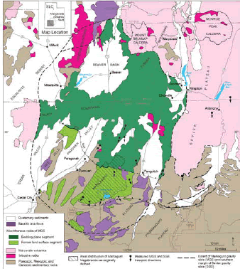 Figure 1. Extent of the Markagunt gravity slide (MGS), which moved as a single, gigantic, catastrophic slide, despite being larger than Rhode Island. The ramp fault is where the slide mass moved southward up and over the former land surface at least 35 km. The Rubys Inn thrust faults resulted from gravitational spreading of the volcanic field prior to MGS emplacement. The southern margin of the newly discovered Sevier gravity slide (SGS, which forms much of the Sevier Plateau), possibly triggered by inflation of the 23 Ma Monroe Peak caldera, is also shown. SLC—Salt lake City.
Description and Objectives
This six-day field forum is designed to investigate the concept of exceptionally large catastrophic collapse of volcanic fields using the distinguishing characteristics and geologic implications of the gigantic Markagunt gravity slide and Marysvale volcanic field, southwest Utah, USA.
Growing evidence of large landslides on volcanic edifices during the past few decades has led to their identification and study at hundreds of volcanoes around the world. Such flank failures and sector collapses are a common form of volcano instability and a significant part of a volcano’s development. However, mega-scale failure of volcanic fields, producing gravity slide structures so large that they blur the boundary between gravitational and tectonic processes, has not been widely recognized.
The newly discovered Miocene Markagunt gravity slide (MGS) in southwestern Utah, USA, provides an ideal setting for investigating the structure and evolution of mega-scale collapse features of volcanic fields. Superb exposures of internal deformation, from source-area breakaway faults to distal debris-avalanche deposits, show that the MGS exhibits the full range of structural features commonly seen in modern landslides, but on a mega-scale. The MGS remained undiscovered for so long precisely because of its gigantic size (>5000 km2, >95 km long, >35 km runout, estimated volume 3000 km3; dimensions revised from Geology, v. 42, no. 11, p. 943–946) and initially confusing mix of extensional, translational, and compressional structures overprinted by post-MGS basin-range tectonism. That features as large as the MGS can remain undetected despite decades of geologic mapping and research in the area suggests to us that other volcanic fields around the world may hold evidence of as-yet-undiscovered, exceptionally large gravity slides. Furthermore, some modern volcanic fields may possess the conditions capable of generating similar large slides. Only the Eocene Heart Mountain gravity slide (HMGS) in Wyoming, USA, is a terrestrial slide of comparable size; it was considered unique until discovery of the MGS.
The MGS represents southward catastrophic failure ca. 22–21 Ma of the southwestern sector of the Oligocene to Miocene Marysvale volcanic field. Recent geologic mapping indicates that the MGS is a large contiguous volcanic sheet of allochthonous andesitic mudflow breccias and lava flows, volcaniclastic rocks, source intrusions, and intertonguing regional ignimbrites. The presence of basal cataclastic breccias, clastic dikes, and pseudotachylyte, the uniformity of kinematic indicators, and the overall geometry of the MGS show that it represents a single catastrophic emplacement event. The MGS preserves the first reported occurrence of landslide-generated pseudotachylyte in North America, among only a handful known throughout the world. Catastrophic failure was preceded by gravitational spreading of the volcanic field, well displayed along the Rubys Inn thrust fault zone in and near Bryce Canyon National Park. Continued late-stage growth of the Marysvale volcanic field, which loaded ever more volcanic rocks on a structurally weak basement of ash-rich volcaniclastic strata, created conditions necessary for gravity sliding. Inflation of the volcanic pile by intrusions above the batholith beneath the heart of the field may have tilted strata on the southern flank gently southward, providing tilted planes for sliding on the underlying weak volcaniclastic strata.
The MGS is significant because it provides a stunning example of gravity-slide structures so large that they may be mistaken for tectonic features. Some low-angle normal faults, including some interpreted as detachment faults, may need reassessment in light of the implications of the MGS. For example, gravitationally driven, unrooted low-angle normal faults that emplace younger rocks on older rocks, called attenuation or denudation faults, are common in the Great Basin. They represent failure of upper parts of ranges along regional shale units following uplift along range-front normal faults and are similar in many respects to the MGS.
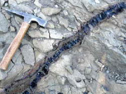
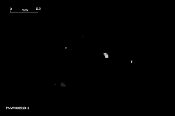
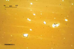
Figure 2. Pseudotachylyte dike sourced from an internal MGS shear surface (A). Photomicrographs of two different samples show (B) isotropic nature of glass with few remaining partially melted plagioclase phenocrysts (crossedpolarized light) and (C) attendant flow structures visible in plain-polarized light. Photos by Bob Biek.
This Thompson Field Forum will Emphasize:
- Different lines of evidence diagnostic of large to small catastrophic gravity slides, using the MGS as an example;
- Cross-disciplinary assessment of extreme deformation processes recorded by basal and lateral breccias and associated clastic dikes, ultracataclasite shear zones, jigsaw-puzzle fracturing of clasts, striations and grooves, riedel shears, breakaway and internal faults, and pseudotachylyte;
- Factors contributing to volcanic landslide initiation and transport;
- The role of magmatic intrusions in inflation of volcanic fields and slope destabilization;
- Gravitational basement spreading of volcanic fields prior to catastrophic failure;
- Comparison of structural features of the MGS with those of low-angle normal faults;
- The use of analog and numerical modeling techniques in simulating the growth of volcanic fields and sector collapse; and
- The possible importance of monitoring radial spreading of modern volcanic fields to aid hazard assessment of potentially catastrophic collapse, not just of individual volcanic cones, but of entire sectors of active volcanic fields.
The subject of large-scale catastrophic failure of volcanic fields will bring together researchers and students—specialists in structural geology, rock mechanics, landslides, volcanology, petrography, tectonics, geochronology, geophysics, sedimentology, and modeling—using different approaches that collectively may yield a better understanding of these rare but complex catastrophic events. The field-based format of this forum will allow for lively discussions, integration of ideas, and development of future research and collaborations. Our goal is to assemble a diverse group willing to look at the MGS from multiple angles. We see significant opportunities for collaborative, cross-disciplinary research not only in our effort to characterize the MGS, but to understand how it relates to other large terrestrial landslides and volcanic provinces throughout the world.
PRELIMINARY AGENDA
The Field Forum will be based out of hotels in Cedar City and Bryce Canyon City, Utah. Some critical outcrops will require
off-trail hiking of 1 or 2 km over locally steep slopes. Elevations are between 1800 and 3400 m.
16 Sept.: Evening ice breaker.
17 Sept., Day 1: Half day of invited and volunteered presentations, then a field introduction to local volcanic stratigraphy.
18 Sept., Day 2: Former land surface segment; age constraints; mechanics of basal breccia formation.
19 Sept., Day 3: MGS breakaway area and western slide margin; ramp fault; catastrophic versus tectonic mechanisms.
20 Sept., Day 4: Bedding-plane segment and features diagnostic of slide margins and catastrophic emplacement.
21 Sept., Day 5: Gravitational spreading of volcanic fields; newly discovered Sevier gravity slide.
22 Sept., Day 6: Wrap-up discussions and plans for future research and collaboration.
ATTENDEES AND ESTIMATED COSTS
The registration fee will cover hotel lodging for six nights (double occupancy), breakfast, lunch, and snacks for six days, handouts, and transportation for the field trip. Airfare is not included and participants must make their own travel arrangements. Registration fees have not been finalized. Please check the GSA website for updates at www.geosociety.org/fieldforums.
APPLICATION & REGISTRATION
Application deadline: 31 Jan. 2017
Registration deadline: 31 March 2017
Participants will have to commit to attending the full six days of the field conference. Group size will be limited to 40 participants. To apply, please contact the conveners through bobbiek@utah.gov with a letter of intent that includes a statement of interests, the relevance of your recent work to the themes of the field conference, the subject of a proposed presentation, and contact information. Interested graduate students and early career faculty are strongly encouraged to apply. Once you have been selected to participate, you will be sent registration information. Please check the conference website for updates.