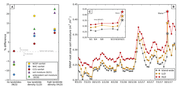
Figure 2.
(A) Deviation from average island-wide rainfall and soil moisture in areas with no, low, and high landslide densities. (B) Soil Moisture Active Passive (SMAP) root zone soil moisture (Reichle et al., 2018) measurements from April 2015–December 2017 (Hurricane Maria shown with stars). (C) Antecedent SMAP root zone soil moisture measurements during the two weeks preceding Hurricane Maria, including the passage of Hurricane Irma. SMAP data were averaged across the entire island and in areas with low landslide density (LLD) and high landslide density (HLD). CCS—PERSIANN-Cloud Classification System; NCEP—National Centers for Environmental Prediction; NHC—National Hurricane Center.