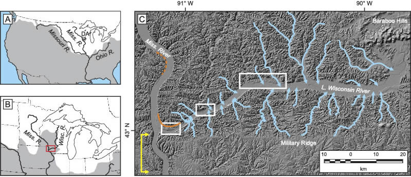
Figure 1.
Location maps of study area. (A) Major tributaries of the Mississippi River system in relation to the maximum extent of all Quaternary glaciations, shown in white. The unglaciated Driftless Area (DA) shown in upper Midwest. (B) Location of the upper Mississippi River and Wisconsin River in relation to the maximum extent of MIS 2 glaciation, shown in white. Area of Figure 1C shown by red box. (C) LiDAR-derived hillshade image of the lower Wisconsin River valley and confluence with the Mississippi River. The three remnant segments of the Bridgeport strath are located within the white boxes, identifying areas of detailed maps in Figure 2. The white circle immediately south of the confluence of the Wisconsin and Mississippi Rivers indicates the location of the town of Wyalusing, Wisconsin, USA. Geomorphological features of the lower Wisconsin River valley that indicate drainage reorganization has occurred: barbed tributaries of the lower Wisconsin River (pale blue arrows); the curved inner valley wall at the confluence of the Wisconsin and Mississippi Rivers (solid orange line) more similar to the inside of a bend on a single river (example identified by dashed orange lines); narrow reach of the Mississippi River immediately downstream its confluence with the Wisconsin River (yellow bracketing arrows).