
Page 4 - gt1607
P. 4
The development and evolution of the William Smith 1815 geological map
from a digital perspective
GSA TODAY | JULY 2016 Peter Wigley, Lynx Geographic Information Systems Ltd, 93-99 distance from one Market Town to another with the exact admea-
Upper Richmond Road, Putney, London SW15 2TG, UK surement prefixed to each from the Metropolis [London]” (Cary,
1796). Cary was aided in this task by material provided by the Post
ABSTRACT Master General, but he also undertook a number of local, detailed
triangulated surveys in order to complete the map. The map was
William Smith’s 1815 geological map of England and Wales produced at a scale of approximately one inch to five miles
is a masterpiece; the map differs from all other contemporaneous (1:316,000) and Cary was to use this map as the basis for the 1815
maps in that Smith applied the principles of stratigraphy to its Smith map.
construction. The maps are extremely rare and therefore not
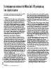
readily available for study and analysis; however, over the past Figure 1 illustrates how the base map was compiled; the three
decade a number of Smith geological maps have been digitally maps are from part of the county of Wiltshire. The top map (A)
scanned and some incorporated into a Geographic Information is from Cary’s 1794 New Map of England and Wales and shows
System (GIS). Early nineteenth-century maps of the United in extraordinary detail roads, canals, rivers, towns, and villages
Kingdom (UK) present a number of difficulties when trying to included by Cary. The middle (B) map is a de-colored Smith
build them into a GIS, mostly related to projection problems and 1815 map and shows how Cary and Smith simplified the road
the fact that many pre-date the “1st Principal Triangulation” of network, reduced the number of towns and villages located (and
the UK. However, once in the GIS, they can be used with great reduced the size and style of the typeface), while at the same
effect to show the evolution of Smith’s maps and also to compare time emphasizing topographic features. Incidentally, Cary, ever
his maps with modern geology. When combined with digital mindful of commercial implications, ensured that the outlines
terrain data, Smith’s maps can be displayed in 3D. of the estates of wealthy landowners were always included. This
map also shows Smith’s engraved geological lines. Map (C) is the
NINETEENTH-CENTURY MAP TECHNOLOGY corresponding part of the 1815 map, which was hand-colored to
show the geology.
William Smith (1769–1839) was an undoubted geological
genius with an amazing eye for the countryside and an ability to Smith’s geological mapping was not limited to the great 1815
think in three dimensions. He was also an expert surveyor, map. Between 1819 and 1824, John Cary published, in six parts,
apprenticed in his youth to Edward Webb (1751–1828) at Stow-on- Smith’s geological maps of 21 English counties. The New
the-Wold, where he learned to measure and value land during the Geological Atlas of England and Wales was used for its base maps.
time of the Enclosure Acts (Torrens, 2001). This skill may have The large county sheets of Cary’s New English Atlas have been
classified him as an artisan in the eyes of the gentlemen of the described as “remarkable for their accuracy and their clear, clean
Geological Society of London and thus precluded his membership print brilliantly engraved, and rank with the Ordnance Survey as
of the Society; however, it was to prove essential in the production the finest maps of the nineteenth century” (Tooley, 1952). Smith
of the great map. Through use of sextant, plane table, and other could not have had a finer set of topographic maps upon which to
surveying instruments (the high-tech of the time), Smith was able draw his geological lines.
to locate outcrops on his field maps. Today with GPS, laser range-
finders, and access to remote-sensing data, the whole process of SMITH’S REPRESENTATION OF GEOLOGY ON THE MAP
map making is very much easier than it was in Smith’s day—yet,
for all that, some eighteenth- and nineteenth-century maps of Smith’s initial problem was how best to show the distribution of
England are remarkably accurate. his strata on maps. Should it be by point locations, lines, or colors?
As we know, Smith chose a combination of both line and color.
It is highly unlikely that Smith’s map would ever have been His colors generally had some lithological significance and indeed
made were it not for the help of John Cary (1755–1835). Cary was are still used today. Smith also used graded tints on his maps, with
a mapmaker, engraver, and publisher; he probably first met Smith the strongest color at the base of the bed at outcrop, lightening
when he engraved his plan of the Somerset Canal in 1793 upward. This is what Smith says in his memoir to the map:
(Torrens, 2007, p. 13). At that time, Cary’s maps were some of the
best available. In 1794, he was commissioned by the Post Office to The Society of Arts very wisely foresaw, in offering their
map towns and roads on his New Map of England and Wales. At premium for a mineralogical map (which I have just had
that time, postal charges were based on distance, and it was there- the honour to obtain), that one of the greatest difficul-
fore important to the Post Office that Cary show “the actual ties in understanding such an extensive branch of
natural history arose from the want of some method of
generalizing the information, which could only be
GSA Today, v. 26, no. 7, doi: 10.1130/GSATG279A.1.
4