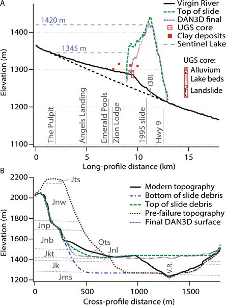
Figure 3.
(A) Long-profile of the Virgin River (V.R.) from The Narrows to the town of Springdale, with extrapolated pre-slide profile (black dashed line). Reconstructed top of rock avalanche deposits is compared to modeled profile. Inset shows simplified schematic of the UGS core. Clay lake bed deposits are projected onto the long-profile. 36× vertical exaggeration. (B) Cross section through the Sentinel rock avalanche deposit showing reconstructed base of slide, top of slide, and original valley profile, compared to model results and modern topography. Qts—sandy talus cone at base of source; Jts—Temple Cap Formation; Jnw—Navajo Sandstone, white; Jnp—Navajo Sandstone, pink; Jnb—Navajo Sandstone, brown; Jkt—Kayenta Formation, Tenney Canyon Tongue; Jnl—Navajo Sandstone, Lamb Point Tongue; Jk—Kayenta Formation; Jms—Moenave Formation, Springdale Sandstone; no vertical exaggeration.