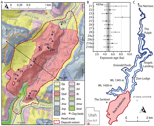
Figure 2.
(A) Geological map of the study area (modified from Doelling et al. [2002] in the landslide area). Units: Qa—Quaternary alluvium; Qt—Quaternary talus (Qts—sandy talus cone at base of source); Qsd—deposits of the Sentinel rock avalanche (in places with >1 m of alluvium or colluvium cover); Jts—Temple Cap Formation; Jnw—Navajo Sandstone, white; Jnp—Navajo Sandstone, pink; Jnb—Navajo Sandstone, brown; Jkt—Kayenta Formation, Tenney Canyon Tongue; Jnl—Navajo Sandstone, Lamb Point Tongue; Jk—Kayenta Formation; Jms—Moenave Formation, Springdale Sandstone; Jmw—Moenave Formation, Whitmore Point Member; Jmd—Moenave Formation, Dinosaur Canyon Member. Orange squares are select exposures of Sentinel Lake clay beds; star shows location of Utah Geological Survey (UGS) core. Circles are cosmogenic exposure age sample locations. Contour interval is 30 m. (B) Results of cosmogenic surface exposure dating showing individual ages and errors, mean age (solid line) of 4.8 ka, and associated standard deviation (gray bar). Samples with open circles were deemed outliers (see text). (C) Estimated extents of Sentinel Lake at its initial high-stand (water level ~1420 m) and later stable level (~1345 m).