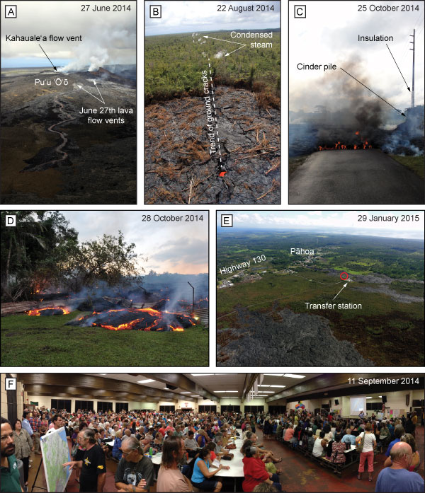
Figure 3.
(A) New vents formed on the NE flank of Pu‘u ‘Ō‘ō cone on 27 June 2014, ~50 m below the elevation of the previously active vent for the Kahauale‘a flows. Aerial view looking WSW. (B) Lava flowed within ground cracks in Aug.–Sept. 2014, with small plumes of condensed steam marking the extent of activity. Aerial view looking ENE along East Rift Zone. (C) Asphalt burns as lava crosses a road on the outskirts of Pāhoa on 25 Oct. 2014. The utility pole at right, surrounded by lava, has been wrapped in insulation and its base covered by cinder. These measures prevented the pole from burning for a time, but after several days, the pole collapsed. (D) Lava crosses through a fence on private land in Pāhoa on 28 Oct. 2014. (E) Several lobes of the lava flow threatened the town of Pāhoa and its highway during late 2014 and early 2015. Aerial view looking south. Damaged transfer station is labeled, and location of house destroyed by lava is noted by red circle. (F) Community meetings in Pāhoa were an effective means of sharing the latest hazards information with the public. During Sept.–Oct. 2014, some individual meetings were attended by more 600 people. Photo locations are indicated by place names and feature labels in Figure 1. All photos by U.S. Geological Survey.